Frontline Test Equipment is now offering the Genos GNSS Simulator, a high-dynamic, flexible signal emulator for testing satellite navigation functionality. It is able to emulate satellite signals visible to GNSS receivers for any location around the world, including GPS, Galileo, GLONASS, Beidou, and SBAS (WAAS and EGNOS) signals.
The simulator helps the user evaluate the performance and characteristics of a GNSS receiver, including time to first fix, acquisition sensitivity, tracking sensitivity, and location accuracy. Also, Genos provides scripting options for creating test configurations that start, stop, raise, and lower attenuation and simulate the various dynamics indicative of cars, airplanes, pedestrians, and other modes of transportation and movement. These customized test configurations can be defined using the Genos user interface or through a script file.
TerraStar GNSS, a supplier of precision positioning services for land and near-shore applications, has established a base at Nottingham University’s GNSS Research and Applications Centre of Excellence (GRACE). GRACE operates operates under the auspices of its Institute of Engineering Surveying & Space Geodesy (IESSG).
TerraStar GNSS maintains and controls a worldwide network of more than 80 GPS and GLONASS DGNSS reference stations and associated control centers on behalf of a diverse range of users. Under the collaborative venture, TerraStar GNSS will contribute and have access to GRACE’s support facilities. These include customized incubation units, project offices, state-of-the-art test equipment, secure research and development laboratories, and dedicated training suites.
Expected projects include joint research and development of new GNSS-type solutions, in addition to provision of support for continued commercial exploitation of academic research endeavors. Also available will be mutual access to general geospatial expertise consistent with TerraStar GNSS’ present capability of providing year-round meter and decimeter-levels of precision for both land and aerial survey applications using software and a series of advanced purpose-designed integrated receivers.
Headed by General Manager Gary Wilcock, TerraStar GNSS’s new base facilities are at Office A03, The Nottingham Geospatial Building, University of Nottingham Innovation Park, Triumph Road, Nottingham NG7 2TU, UK.
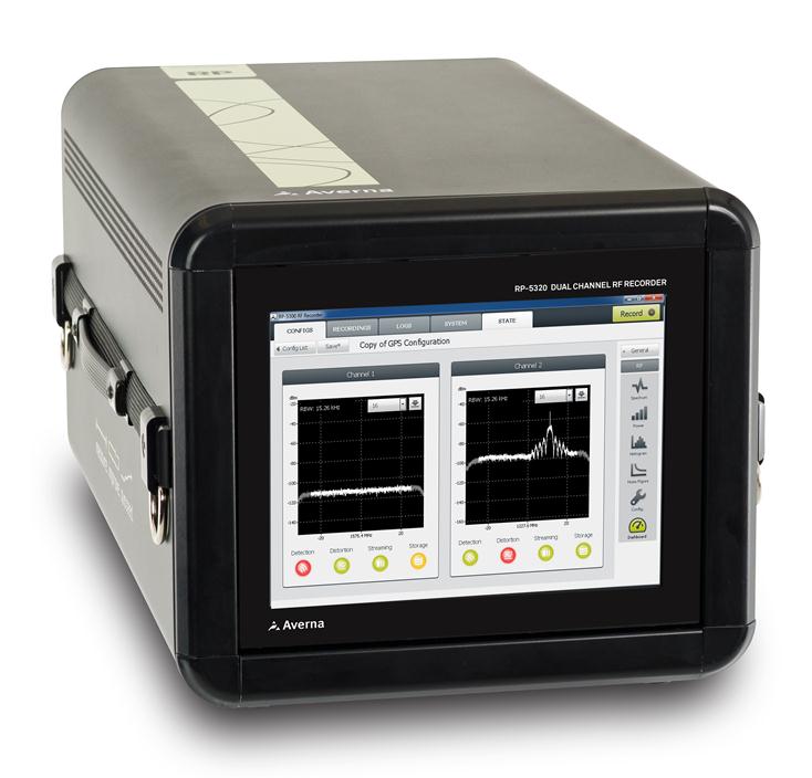
Averna’s Record & Playback platform. Photo: Averna
Averna, a developer of test solutions and services for communications and electronics device makers, announced today that Clarion has selected Averna’s Record & Playback solution to validate upcoming in-vehicle entertainment systems and certify that the devices perform well in real-world conditions. Clarion is a global manufacturer and seller of car navigation systems and in-vehicle equipment with a focus on car audio systems.
The R&D Division, Experiment and Evaluation Team at Clarion will use Averna’s R&P platform to record radio signals such as AM, FM, HD Radio, and DAB from key locations around the world and replay them in the Tokyo-based lab where the design team is located.
The R&P platform selected by Clarion features:
RP-5100, a compact 2-channel RF recorder designed to record live RF signals in the field
URT-5000, a software-defined RF Player and Signal Generator
RF Studio, high-performance RF record-and-playback software for RF product designers and researchers to facilitate recording, analysis and storage of RF signals
DriveView plug-in for synchronized recording/viewing of video, audio, and GPS positioning data
The Averna RP-5100 RF Recorder is specifically designed to capture real-world RF signals, with impairments, for navigation as well as broadcast radio and video receiver validation, testing and support. The system has two 20-MHz wide channels that can be tuned on any frequencies from 250 kHz to 2.65 GHz. To address the challenges of validating the RF response with the physical environment, Averna has developed DriveView, a plug-in for the proprietary RF Studio software, offering visual verification by video-recording drive tests.
“Clarion needed a platform to record live RF environments and reproduce them in a repeatable manner in their lab. Our R&P solution allows them to go through all the different use cases without having to go back in the field at each testing phase,” said Etienne Frenette, VP of Sales, Asia for Averna. “As receivers become more complex, it is imperative that real-world signals and conditions be recreated for thorough validation and testing in order to help enhance the user experience.”
“We recognize and appreciate Averna’s unique expertise and advanced solutions in device performance testing,” commented the R&D Division, Experiment and Evaluation Team at Clarion. “Clarion is dedicated to delivering better products reaching the market faster and Averna is helping us achieve this goal.”
Rohde & Schwarz provides developers of satellite-based navigation instruments with a global navigation satellite system (GNSS) simulator, which runs on the R&S SMBV100A vector signal generator. The new R&S SMBV-K101 option allows developers in the automotive and wireless communications industries, for example, to test GNSS receivers for specific effects such as obscuration and multipath propagation. Buildings, tunnels and bridges as well as reflections from concrete and glass surfaces affect the GNSS signal, regardless of whether the receiver is stationary or in motion. This option makes it easy to configure these kinds of scenarios.
If the GNSS receiver of a navigation instrument or smartphone is located inside a vehicle, testing must also take into account the obscuring effect of the vehicle’s metal body. The R&S SMBV-K102 option can simulate this obscuration and, if required, also the additional antenna pattern.
In addition to test scenarios for A-GPS, smartphone developers also have the Assisted Galileo (R&S SMBV-K67) and Assisted GLONASS (R&S SMBV-K95) options at their disposal. (Mobile radio networks transmit location-specific information to wireless devices via A-GNSS so that they can determine the current position faster.)
In many cases, navigation instruments handle signals of digital communications standards other than GNSS. As the first GNSS simulator of its kind on the market, the R&S SMBV100A also supports these standards. Now, manufacturers of mobile phones and car radios with integrated GNSS receivers need just one signal generator to test multiple functionalities. The R&S SMBV100A can also be used to perform interference tests on the DUT.
Users in the aerospace and defense industry can use the R&S SMBV-K103 option to simulate the relative position of a flying object as well as its rotation at a rotation rate of up to 400 Hz. This allows developers to perform lab tests to determine how a flying object’s different positions, the ground reflection of GNSS signals and rotary movements affect reception quality.
The GNSS simulator in the R&S SMBV100A uses up to 24 satellites to generate signals in realtime for GPS with civilian C/A code and military P code as well as for Glonass and Galileo in different constellations. In just a few steps, users can define their own scenarios for testing their GNSS receivers under various conditions. The R&S SMBV100A is the only GNSS simulator on the market that does not require an external PC. As a result, it is easier to automate, and test setup is simple.
The new options for the GNSS simulator in the R&S SMBV100A are now available from Rohde & Schwarz.
Spirent Communications’ new SS6425 multi-frequency GNSS record and playback (RPS) test system provides RF recordings for more constellations (GPS, GLONASS, Galileo, BeiDou, QZSS), more frequencies (L1, L2, L5), wider bandwidth (30MHz) and more features than the company’s previous systems, to support a wide range of positioning and timing test applications.
The test system is self-contained and portable, enabling users to record and playback data in the field without the need for an additional PC or external power. With the GSS6425, it is simple to faithfully capture and replay complex signal conditions, such as urban environments, indoor spaces like airport terminals, and dense forests, Spirent said. Multiple environments can be brought into the lab and replayed in a repeatable and controlled manner, helping developers improve receiver and system performance.
“Customers have told us they want to record multi-GNSS signals simultaneously, for example GPS, GLONASS and BeiDou,” said Rahul Gupta, product manager for Spirent’s positioning division. “They have also told us that capture and playback of other data, such as inertial or vehicle CAN bus is needed. The GSS6425 enables all this in a very capable, yet easy-to-use and self-contained unit.”
Users can select and record three GNSS frequency bands at any one time, each with up to 30MHz bandwidth. If more than three concurrent channels are required, two GSS6425 units can be synchronized in a master and slave configuration. For example, survey-grade receiver developers can capture GPS L1, L2 and L5 signals, GLONASS L1 and L2, plus satellite-based augmentation system (SBAS) signals such as StarFire or OmniSTAR.
The GSS6425 is also capable of recording additional sources including inertial and dead reckoning sensor outputs and vehicle CAN bus data. Data can be time-stamped and stored in the GNSS data file, ensuring synchronized playback. The GSS6425 can also record the GPS receiver 1pps (pulse per second) output for synchronization purposes. These features are particularly useful in developing hybrid receivers such as for automotive and indoor positioning applications, Spirent said.
Key features include:
Multiple constellations and frequencies
GPS, GLONASS, Galileo, Beidou, QZSS
L1, L2, L5
Self-contained portable unit
No PC or external drives required
Control from front panel, webserver or scripts
OCXO used on record and playback for frequency stability
Internal 1TB hard drive with additional removable 1TB hard drive
Synchronization of two units in master/slave configuration to support total of 6 frequencies
Store asynchronous or synchronous external data at the same time as GNSS signals
Recorder features:
Record any three RF grequencies simultaneously
Internal battery (up to 1.5 hr) and vehicle DC power adapter
2-bit quantization
Single-touch record
Event markers
Playback features:
Attenuation control per channel
Browser control over network
Multiple file playback
Start at any point in a file
Scripts allow inclusion in automatic test routines
Rohde & Schwarz and 7Layers have verified and validated the synchronized test approach to determine the Envelope Correlation Coefficient (ECC), a value characterizing the antenna subsystem of multiple-input and multiple-output (MIMO) LTE devices. The Synchronized ECC approach delivers significantly shorter test durations and repeatable results, ultimately resulting in reduced costs. Long term, this collaboration will also help product manufacturers develop devices that achieve greater data speeds over LTE by using highly optimized MIMO antenna configurations, the companies said.
The Synchronized ECC approach involves over-the-air transfer of measured data between the test platform and a mobile device in a synchronized fashion. This method, proposed by a leading U.S. wireless carrier, does not require any overhead or user interaction to calculate the ECC, making it easier and faster to execute test versus other approaches. 7Layers test engineers used the Rohde & Schwarz TS8991 OTA Performance Test System and software option R&S AMS32-K30 as a test platform for validation.
”7Layers is excited to help bring an ecosystem of vendors together to advance testing of LTE enabled devices utilizing MIMO,” commented Mahesh Kodukula, business development manager of 7Layers. ”As an accredited test laboratory, we provided a realistic test environment for our partners.”
”We are pleased to enable this type of testing on our R&S TS8991 OTA test platform and to offer this functionality to a variety of customers that have been waiting for this feature,” said Thorsten Hertel, OTA product specialist at Rohde & Schwarz. ”We strive to meet the industry needs of the leading edge development of LTE devices.”
Visit Rohde & Schwarz at CTIA 2013, May 21 23 at booth 4148 in the Sands Expo and Convention Center, Las Vegas, NV.
RTKLIB, a developer of open source software for standard and precise GNSS positioning, has released its latest RTKLIB software (version 2.4.2), which fully supports NVS Technologies’ BINR proprietary binary protocol and the NV08C GNSS receiver series.
The use of RTKLIB, in conjunction with NVS Technologies’ NV08C GNSS receiver series, including the highly integrated NV08C-CSM surface mount module with geodetic grade raw data output, enables GNSS system designers and OEMs to develop highly accurate, low cost and compact precision-grade positioning and navigation equipment.
RTKLIB features include:
Full compatibility with NVS Technologies’ NV08C Series GNSS Receivers.
A portable program library and several APs.
Standard and precise positioning algorithms using GPS, GLONASS, Galileo, QZSS, BeiDou and SBAS.
Supports various GNSS based positioning modes, both for real-time and post-processing, including: Single, DGPS/DGNSS, Kinematic, Static, Moving-Baseline, Fixed, PPP-Kinematic, PPP-Static and PPP-Fixed.
Positioning mode for real‐time and post‐processing, including Single, SBAS, DGPS, RTK, Static, Moving‐base and PPP.
Supports many standard formats and protocols for GNSS, including RINEX 2 & 3, RTCM 2 & 3, BINEX, NTRIP 1.0, RTCA/DO-229C, NMEA 0183, SP3-c, ANTEX 1.4, IONEX 1.0, NGS PCV and EMS 2.0.
External communication via Serial, TCP/IP, NTRIP, local log file (record and playback) and FTP/HTTP (auto download).
Contact NVS Technologies for specific features compatibility. Visit www.rtklib.com for RTKLIB’s latest (ver. 2.4.2) software package download, release note, information, tutorial, manual and support.
Sponsored by: Hemisphere Broadcast Date: Thursday, May 16, 2013 Moderator:Alan Cameron, Editor & Publisher, GPS World Speakers: Mark Sampson, LabSat Product Manager, RaceLogic; John Fischer, Chief Technology Officer, Spectracom; Markus Lörner, Product Manager, Rohde & Schwarz; Steve Hickling, Lead Product Manager, Spirent Communications; Mark Wilson, Vice President of Sales, IfEN GmbH
Simulation and testing experts offer key technical insights on the intricacies and importance of product and signal testing, whether by simulator, record-and-replay, or in the field, in the increasingly complex environment of multiple modernizing and expanding GNSS signals, from GPS III to BeiDou, with Galileo coming on strong and GLONASS a perennial standby.
It used to be that if you were going to build an RF navigation receiver, you had to also build your own simulation system to test it. I remember working with a couple of “home-built” RF simulation systems myself, way back when. We experience a lot of maintenance and support issues. And, of course, if you build something and also build something to test it, its likely that incorrect assumptions will end up in both systems. Today, there are a number of excellent sources for GNSS simulation equipment and support you can buy on the open market.
The spectrum of today’s providers seems to range from highly sophisticated scientific systems used for development by precision receiver manufacturers, through systems with GNSS and aiding solutions, to specialized systems for both general and specific application developers and also for production test. So this month I’d like to try to summarize (in no particular order) what some of the suppliers of GNSS simulation systems are up to, how they may be positioned in the market and, wherever possible, what we might expect to see from them in the future.
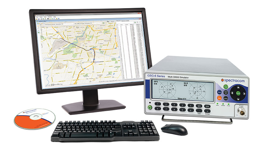
GSG Series 6 GNSS simulator.
Spectracom is a more recent entrant to the GNSS simulation market, though the company has been providing frequency and time synchronization test equipment for about 40 years. Spectracom has integrated GPS into these products for more than ten years, and decided three years ago to use the knowledge it had gained to get into the GNSS simulation business.
The GSG family of simulators is positioned at the “affordable” end of the simulation equipment scale, and is targeted at users and integrators of GNSS, rather than developers of receivers. Spectracom claims to have about 80 percent of the features of the top-end simulations systems, but its more capable (Series 6) systems sell in the $20-30k range. While new to the business, the Spectracom team feels that this allows them to bring the newest technology and innovation to the market.
The Spectracom system is derived from its well-known frequency/time synthesizer equipment — in fact, it has the same look front panel and chassis — and also makes use of the same “easy-to-use” concepts. “It doesn’t take a navigation scientist to operate these simulators,” said John Fischer, chief technology officerat Spectracom. The accompanying Studio View software is reportedly relatively easy to use to generate trajectories and other test scenarios by connecting to Google Maps and uploading them to the simulator.
But with all new firmware and FPGA implementation, 64 channels, and four frequency bands covering both GPS and GLONASS, the GSG family appears to be very well positioned for application developers integrating GNSS. Galileo and Beidou/Compass are in the works and expected this year, and will be supplied as upgrades to existing equipment.
Spectracom anticipates significant growth in its target market for application developers in “anything that moves,” including automotive and airborne, video matching, radar/lidar, and handheld nav devices, including mobile phones. Spectracom has a number of product lines and around 100 people working for them, but the GNSS simulation group is around 12 strong.
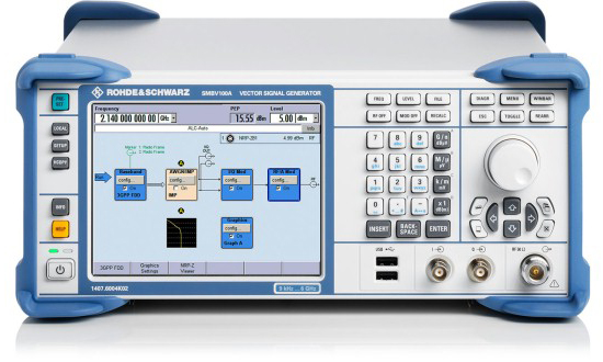
Rohde & Schwarz is another relatively recent GNSS simulation entrant with new products for the market.
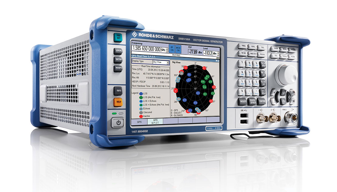
SMBV100A vector signal generator.
Its current offering — the SMBV100A Vector Signal Generator – can simulate 24 dynamic GPS, GLONASS and Galileo satellites. The SMBV 100A has wide bandwidth and high output power levels. Real-time test scenarios can be customized by the user — including a neat facility that allows modeling of satellite masking by downtown buildings, along with anticipated multipath for the same urban scenario.
While somewhat new to GNSS simulation, R&S has been around since the 1930s, and its experience with frequency synthesizers and similar equipment is being carried forward into what the company terms its “cost-effective” GNSS simulation offerings. R&S anticipates significant growth in automotive, aerospace, UAV, and cellular assisted-GNSS application markets.
R&S has had success in the aerospace market for UAVs, and has developed the capability to model antenna patterns and UAV body mask as the vehicle rotates and attitude changes towards visible satellites. Along the same lines, R&S has hooked up its system to flight simulators and provided hardware-in-the-loop testing for clients. R&S also has the ability to run simulation scenarios for long periods of time, and for “very long” periods if the receiver is stationary — this feature makes use of large internal memory storage within the SMBV100A; of course, almanac validity limits just how long this is possible. P-code capability is provided as an option, and there is a roadmap for adding SBAS and Beidou capability later.
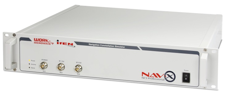
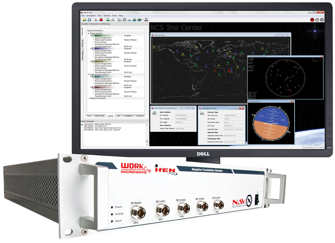
IFEN NavX-NCS Professional
In the meantime, IFEN in Germany is focusing on its NavX-NCS Navigation Constellation Simulator range of multi-GNSS signal simulators.
IFEN emphasizes the flexibility of its design, with a platform scalable from a 12-channel GPS L1 system up to a full multi-GNSS system with 108 channels and 9 frequencies for GPS, GLONASS, Galileo, QZSS and SBAS. With this building-block approach, channels and capabilities can be added as and when additional testing complexity is required.
IFEN claims that the capability to generate all GNSS signals — by combining different modulations with up to nine L-band frequencies — is the only existing solution on the market providing GPS, Galileo, GLONASS, QZSS and SBAS in one chassis at the same time. And, since April 2013, all IFEN NavX-NCS GNSS RF signal simulators are to include BeiDou B1 signal capability in accordance with the official Chinese BeiDou B1 ICD, and are ready for the other B2 and B3 BeiDou signals.
IFEN also founded a subsidiary in the USA in January this year called IFEN, Inc., located in California and operational with Mark Wilson (formerly with Spirent) as VP Sales. In addition, IFEN has formed a partnership with WORK Microwave — a leading European manufacturer of advanced satellite communications and navigation equipment. WORK Microwave is responsible for RF and digital hardware design while IFEN develops the associated software and manages the distribution of the product range.
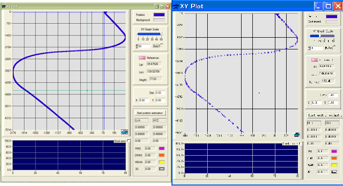
Little-known IP-Solutions in Tokyo, Japan, has been working to develop its ReGen GNSS DIF signal simulator, a software simulator that simulates ionospheric effects, generates digital IF (DIF) signals similar to those recorded by an RF recorder, and comes with an optional capability of simulating integrated inertial navigation.
IP-Solutions’ digital IF baseband signal simulator ReGen has been developed in close cooperation with the Japan Aerospace Exploration Agency (JAXA) to test and validate GNSS signal processing algorithms and methods for use on board aircraft using tight and ultra-tight integration with INS, including specific scintillation models and ionospheric bubble simulation.
Actual recorded flight data (left), ReGen replicated flight data (right).
Various configurations of ReGen can produce multichannel GPS and GLONASS L1 signals and single-channel GPS L1, L2, L5 and GLONASS L1 and L2 signals, as well as simulating noise and interference.
Meanwhile, Spirent, arguably the original market leader in GNSS simulation, has continued along its chosen path of supplying the industry with the greatest capability and most extensive simulation systems.
Spirent has recently released test systems with support for China’s BeiDou Navigation Satellite System in addition to GPS, GLONASS and Galileo.
Spirent started shipping BeiDou-ready systems to its customers in 2012. Now these may be upgraded to full BeiDou capability using the information available in the first full issue of the BeiDou-2 Signal In Space Interface Control Document (ICD).
Also aiming at mobile applications, Spirent’s Hybrid Location Technology Solution (HLTS) integrates Wi-Fi, Assisted Global Navigation Satellite System (A-GNSS), Micro Electro-Mechanical Systems (MEMS) sensor and cellular positioning technologies. HLTS integrates four very different and distinct location technologies and provides repeatable and reliable lab-based characterization of mobile devices supporting hybrid location technologies that will enable “accurate everywhere” location — including indoor user location determination.
Other notable players in the GNSS simulation business include Racelogic, CAST Navigation and Agilent who are each pursuing their chosen niches in this expanding market segment. Racelogic’s LabSat GPS simulator is gaining popularity with a number of leading companies, providing the ability to record and replay real GNSS RF data as well as user-generated scenarios. CAST has an extensive line-up of GPS and GPS/INS simulation systems and support software, and Agilent has added to its impressive electronic testing portfolio with a very capable looking GPS simulation product line.
Several other companies — some based in China and Russia — are also trying to figure out their development and marketing strategies to conquer their chosen GNSS simulation market niche. This is all a very healthy sign that there are many other companies with new embedded GNSS applications that they are bringing to market and who therefore need GNSS simulation/test capability. Overall, this means there is still significant growth underway and far wider applications of GNSS on their way to market. Great news for the GNSS industry!
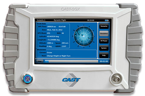
The SGX GPS satellite signal simulator from CAST Navigation provides the user with dynamic, repeatable GPS RF signals for use in the laboratory or in the field for a wide range of GPS applications. The SGX simulator is housed in a portable, lightweight handheld enclosure measuring 7 × 11× 3 inches and weighing just over 4 pounds.
The SGX replaces the CAST-SIMCOM simulator, a 17-inch, 50-pound simulator. The SGX is lightweight, portable, operates on AC or battery power, features 16 channels of L1 C/A- and P-codes, and is extremely accurate and repeatable. It is based on CAST technology that has been developed for use in the company’s larger military products.
The SGX is controlled via an intuitive touchscreen interface that allows the user to select start and stop scenarios, change screen views, and change satellite RF power levels while a scenario is running. Three test scenarios are delivered with the simulator.
XGen Scenario Generation Software. This optional software gives the user the ability to generate custom scenarios for use with the SGX. The software allows for complete control over GPS almanac, ephemeris, and all satellite error sources, including multipath. The user can select from a variety of vehicle types and simulate static or dynamic motion for land, sea, air, and space-based vehicles. The user may also employ antenna gain patterns and vehicle silhouettes.
IFEN Inc., located in California, offers the IFEN NavX-NCS (Navigation Constellation Simulator), a premium-grade RF GNSS simulator. It is available in either the Essential or Professional version, tailored to the customer’s individual test and research needs.
The NavX-NCS Essential simulates dynamic and static GNSS scenarios with up to 42 channels in the upper L-band (such as GPS / SBAS L1, GLONASS G1, Galileo E1, BeiDou B1, and QZSS / IMES L1) and is designed mainly for product testing and system integration.
The NavX-NCS Professional offers up to 108 signal channels in virtually all frequencies and signals. Superior simulation options such as various feared events can be performed by the NavX-NCS Professional.
Both versions of NavX-NCS offer high precision and numerous simulation options. Intuitive, user-friendly software makes test scenarios easy, fast, and clear, whether pre-defined or set up individually.
These IFEN simulators have a unique modular hardware and software architecture, which offers great flexibility when it comes to changes in a company’s strategic test requirements. Every NavX-NCS is fully upgradeable, not only in the number of RF signal channels or available frequencies, but in a possible subsequent supplement of up to four RF outputs.
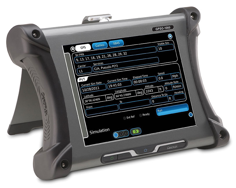
Designed to be a versatile yet affordable satellite simulator, the GPSG-1000 is used by those validating and testing GNSS receivers in a variety of applications in the transportation, consumer electronics, aerospace, and military industry segments, to name a few. The GPSG-1000 is a single carrier, multi-channel GPS/Galileo simulator. Portable and ruggedized, it can be safely and confidently deployed in a variety of outdoor and indoor environments. The unit is available in a 6- or 12-channel configuration, and supports L1, L1C, L2C, L5, E1, E5, E5a, E5b, and SBAS (WAAS and EGNOS) signals.
The GPSG-1000 can be directly connected to a GNSS receiver under test. It can also simulate actual “open sky” situations, whereby the unit can generate its signals through the included antenna coupler system that isolates and transmits to the UUT’s antenna(s). Utilizing an integrated GPS receiver, the GPSG-1000 simulates actual time of day and date as well as the real constellation that would be available for navigation at that specific time. Multiple almanacs and route files can be saved to memory, enabling current and past history dynamic motion, constellation environment creation/recreation, and other troubleshooting capabilities. During any given static or dynamic simulation, space vehicle parametrics and health can be user controlled.
At less than 10 pounds, the GPSG-1000 features a touch-screen user interface that can be remotely hosted via an integrated Ethernet port. The unit uses a rechargeable, lithium-ion battery, enabling hours of untethered use, or can be used while the battery is recharging.
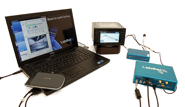
LabSat and LabSat 2 are record and replay multi-constellation GNSS simulators. Designed as lightweight, easy-to-use standalone systems, the LabSat range has the ability to provide and deliver solutions for a wide range of testing requirements. Equipped with pre-recorded test scenarios and the ability to record and replay the user’s specific scenarios, LabSat delivers precise and accurate test results — replicating real-world situations in the lab or testing facility.
The range also has the ability to record and replay data from a wide range of data sources, including vehicle CANbus, inertial sensors — such as gyrometers and wheel speed sensors — and reference receivers. A recent innovation is the LabSat Turntable Solution, which allows for the replay of dead-reckoning turn-rate signals to be played into a navigation device to simulate use through built-up areas and urban canyons. Both LabSat and LabSat 2 can observe all satellites in view; while LabSat observes GPS, Gallileo, and SBAS, LabSat 2 includes GLONASS and BeiDou-2.
Reliability of the gathered data can be assured when used together with SatGen v2, Racelogic’s simulation software. This scenario-generation software enables users to create scenario files based on user-defined trajectories, which can be replayed on LabSat. With SatGen v2, a scenario can be generated anywhere in the world, with position, route, speed, and time defined by the user. This high-performance software allows users to verify that their GNSS equipment performs as required in a variety of locations that maybe geographically remote or unavailable due to hostile environments.
Rohde & Schwarz R&S SMBV100A: GNSS Simulator on Vector Signal Generator
Rohde & Schwarz
R&S SMBV100A: GNSS Simulator on Vector Signal Generator
The GNSS simulator in the vector signal generator R&S SMBV100A is designed for development, verification, and production of GNSS chipsets, modules and receivers. The simulator supports all possible scenarios, from simple setups with individual, static satellites all the way to flexible scenarios generated in real time with up to 24 dynamic GPS, GLONASS, and Galileo satellites.
GNSS simulator with support of GPS L1/L2 (C/A- and P-code), GLONASS L1/L2, and Galileo E1, including hybrid constellations.
Simulation of realistic constellations with up to 24 satellites in real time (no precalculated waveforms).
Flexible scenario generation including moving scenarios (import of NMEA waypoints), multipath, dynamic power control, and atmospheric modeling without the need for additional software tools.
Unlimited simulation time with automatic, on-the-fly exchange of satellites.
User mode in the GNSS simulator for full flexibility to select the satellites and to define the navigation data (import of RINEX files).
Full localization for static and moving receivers with up to eight satellites with GPS P-code plus commercial C/A-code for complete testing of military receivers.
Support of predefined and user-defined A-GPS test scenarios, including generation of assistance data.
Easy way for time synchronous setup with two instruments for L1 and L2 band simulation.
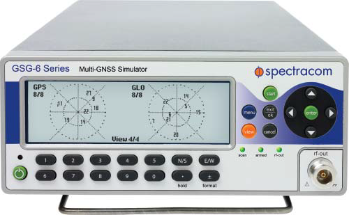
Spectracom’s line of simulators provides fast, comprehensive navigational, position, and timing testing for devices with GPS receivers. Designed for manufacturers and development engineers, Spectracom’s simulators provide complete testing of multi-channel GPS signal performance with high throughput and ease of use without unnecessary complexity or expense. All GSG-5 and GSG-6 series models are portable and fully operational via front-panel, web-based remote control, or SCPI protocol, and they operate with StudioView for easy scenario creation and file management. Most models are software upgradeable so users can easily add features as requirements change.
GSG-5 Series. The GSG-5 series is a GLONASS and GPS constellation simulator that provides the basic set of features for testing GNSS systems. With a base of four channels, upgradable to 8, 16, or more, it provides navigational fix and position testing for in-line product testing or basic engineering and development testing.
Versatile multi-channel GLONASS + GPS signal generator with pre-configured test scenarios.
Includes advanced features such as SBAS (WAAS, EGNOS, MSAS, or GAGAN), white noise generation, and multipath simulation.
GSG-6 Series (pictured). The GSG-Series 6 family offers multiple frequency band operation, multiple GNSS constellation simulation, and expansion to many more channels. Incorporating all of the features of the popular Series 5 family, the Series 6 line expands the capability to simulate all the new, emerging GNSS signals. With a base of 32 channels, upgradable to 48, 64, or more, it provides navigational fix and position testing for engineering and development testing.
GPS standard, new (L2C, L5) GLONASS, Galileo, and Beidou/Compass coming soon.
Simultaneous multi-frequency P-code (unencrypted) and C/A code.
Simultaneous GNSS Constellation P-code and C/A codes.
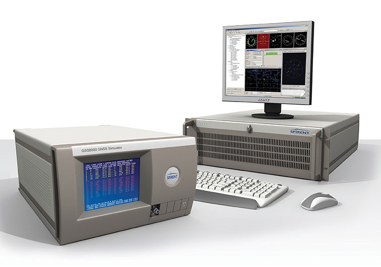
Spirent provides simulators that cover all applications, including research and development, integration/verification, and production testing.
GSS8000 (pictured). Spirent’s flagship simulator, the GSS8000, is fully approved for Y-code, SAASM, AES M-code, and SDS M-code testing. Spirent provides options and configurations for testing GNSS interference effects and interference mitigation techniques, such as integrated GPS/inertial testing, CRPA testing, and jamming/anti-jam simulation.
Spirent has delivered simulators that produce both legacy signals as well as modernized signals such as 2C, L5, and L1C. In addition to GPS, systems can include GLONASS L1/L2, Galileo, and Beidou-2, plus SBAS (WAAS, MSAS, and EGNOS) and Japan’s QZSS.
CRPA Test System. Spirent’s Controlled Reception Pattern Antenna (CRPA) Test System generates both GPS L1/L2 and interference signals; multiple GSS8000 chassis may be combined to coherently control up to seven antenna elements. Null-steering and space/time adaptive CRPA testing are both supported by this comprehensive approach.
GSS7790. Spirent’s GSS7790 Multi-Output Simulation System allows the signal from each satellite to be mapped to a separate RF output. These signals can then be fed to individual transmit antennas, which, when suitably deployed in an anechoic chamber, replicate the spatial diversity of satellite and jammer signals incident on the receiver antenna. Additional flexibility is offered as the signal is further split into its GPS L1 and L2 components, as appropriate.
GNSS is changing. The days of only American GPS satellites providing signals to the civilian population are gone as new constellations are launched. GLONASS was a slow starter, but is now well established, and its signal architecture is now commonly implemented in manufacturers’ chipsets. Galileo is still very much in test phase with global coverage planned for 2019, although position fix using only Galileo satellites has already been demonstrated. The Japanese QZSS system, designed to aid navigation in urban canyons, is partially operational with further launches announced for the near future.
The latest openly documented network to come online is BeiDou-2, or BDS. Formerly known as Compass, the Chinese constellation now provides signals to China and surrounding areas, but plans for global coverage should come to fruition by the end of the decade.
Full control over its own constellation gives a country military, socio-political, and commercial advantages, especially if additional functionality — such as search and rescue services — is introduced alongside the standard navigational broadcast. BDS is unique in its use of a combination of standard-orbit and geo-synchronous satellites, the latter giving it a wider range of signal designed to carry more information.
The populace stands to benefit from a wide variety of localized and global satellite coverage, but only if there are end-user products available that actually make use of the new signals. Any manufacturer wanting a share of the market in China, for instance, will need to get BeiDou-2 integrated into its chipsets quickly, especially if an import levy is placed upon devices that don’t support it (as nearly happened with GLONASS).
How do you go about implementing BDS support in your new GPS product if you’re based in Europe or America? The coverage isn’t global yet; you can’t just go out into the office car park to test, and how are you going to incorporate the signals from the three geostationary satellites without actually being underneath them? Moving to China isn’t very practical, so the solution is a GNSS record-and-replay device.
Manufacturers and other customers will want to seek out simulators from companies that have been highly proactive in ensuring their products provide full support for each constellation, even before they come fully online. The convenience in being able to test new designs, applications, and system integration with reliability and consistency can bring significant savings in development cost and time.
With 14 BDS satellites currently in operation, and the recent release of the Interface Specification, we find more and more companies in the marketplace have been asking for BeiDou functionality. An added benefit for existing users would be flexible hardware capable of taking a simple firmware upgrade in order to record and replay BeiDou as well as GPS and GLONASS.
Icing on the system-testing cake would be a hard drive containing pre-recorded scenarios from China and Europe, with good BDS visibility, so that bench testing can commence immediately. Given that such a device can record raw signals, live recordings can be taken in Asia and then transferred to test facilities around the world.
Mark Sampson is Racelogic’s LabSat product manager. He has more than 15 years of experience in the development of GNSS technology. Working closely with leading businesses such as Bosch, Intel, Samsung, and Telefonica, he provides knowledge and expertise in testing any GNSS device, application, or integration.
GNSS have been with us for more than 30 years, giving rise to a wealth of positioning and navigation technologies for military, civilian, and consumer use. Today, we’re entering a new era of experimentation and innovation in satellite and hybrid positioning. In turn, this drives new test challenges and introduces an ever wider group of engineers to the art and science of GNSS test.
Where Is the Testing Panacea? I am sometimes asked, “What is the best way of testing a GPS receiver?” — as if there existed some laboratory panacea to all GNSS test and characterization woes. Well, there is a saying, “There are horses for courses,” meaning what performs well in one situation may not deliver in another, and nowhere is this more true than in the field of GNSS test. Not only is there a wide range of different test equipment available, but there are no universally applicable test objectives, test methods, or parameter definitions, in exactly the same way as there is not one universally applicable GNSS receiver. Just as the rapid time-to-first-fix of an automotive receiver may be less relevant in a maritime environment, so different test approaches have their place.
A Systematic Approach. If there is one thing, it is this: be systematic in your test design. Consider the purpose of the test, the test conditions, and the measurements you plan to take, and be wary of generic tests that may not achieve your objectives.
Equipment. A wide range of GNSS testing equipment is available, ranging from basic single-constellation RF simulators to highly configurable, multi-GNSS constellation simulators. Single-channel, multi-channel, and record and playback systems all have their place, and to get the best results in the fastest time, it’s essential to choose the kit that’s right for the kind of testing you need to do.
Vulnerability, Fidelity, Integrity, and Time Travel. More and more, receivers need to be tested for their vulnerability to interference, jamming, and spoofing. As GNSS-derived position and time become more ubiquitous, so the motivation for confounding the system grows. This has a double impact on test.
First, performance requirements around vulnerability may be introduced, with tests to match. Second, and perhaps less obvious, is the way in which this concern is reflected in the receiver’s design and potential rejection of the laboratory test signal. Yes, I mean receivers getting more fussy about the signals they lock onto. Anyone who has tested a receiver with an out-of-date recording or simulation scenario will have experienced a receiver refusing to track a satellite showing a time and date prior to its firmware release date. The receiver, discounting time travel, knows there has to be something wrong with a satellite showing a date before it was born. With the risk of spoofing, receivers will only get more picky and likely to reject poorly simulated signals. To avoid such effects, it is important to have very high integrity and fidelity in any simulator system. Getting these details right is not esoteric, but is essential to allow the proper attribution of any problems observed and if test results are to have any meaning.
Conclusion. Be systematic in your approach to test; beware the universal and generic; “good enough,” it rarely is.
Steve Hickling is lead product manager for Spirent’s GNSS simulator business and is based at the factory in Paignton, England. Previously he held a variety of marketing, technical, and management roles in the telecoms and optical components industries. He holds a bachelor of science degree in physics and electronic engineering from Birmingham University, an MBA from Open University Business School, and a post-graduate diploma from the Chartered Institute of Marketing.
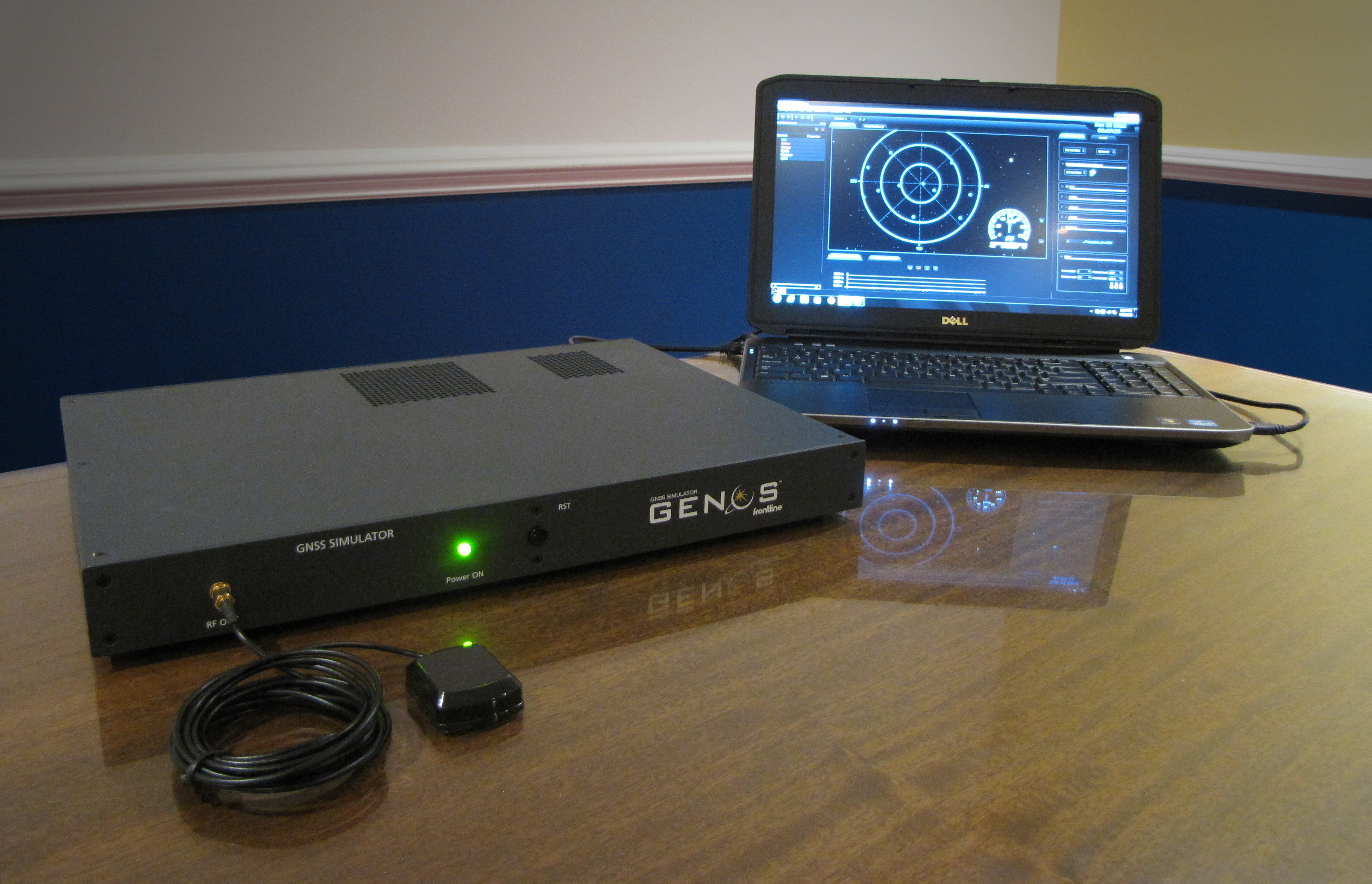 Frontline Test Equipment is now offering the Genos GNSS Simulator, a high-dynamic, flexible signal emulator for testing satellite navigation functionality. It is able to emulate satellite signals visible to GNSS receivers for any location around the world, including GPS, Galileo, GLONASS, Beidou, and SBAS (WAAS and EGNOS) signals.