On Feb. 12, President Donald Trump signed an Executive Order establishing a comprehensive national policy to promote the responsible use of positioning, navigation and timing (PNT) services by the federal government.
The order directs federal agencies to take steps to reduce disruption of critical infrastructure that relies on PNT, including GPS. It also directs critical infrastructure owners and operators to strengthen their systems’ resilience.
Markets affected include including the electrical power grid, communications infrastructure and mobile devices, all modes of transportation, precision agriculture, weather forecasting and emergency response.
The federal government will engage both the public and private sectors to identify and promote responsible use of PNT services, with the goal of ensuring that “critical infrastructure can withstand disruption or manipulation of PNT services.”
“Because of the widespread adoption of PNT services, the disruption or manipulation of these services has the potential to adversely affect the national and economic security of the United States,” the order states. “To strengthen national resilience, the Federal Government must foster the responsible use of PNT services by critical infrastructure owners and operators,” the order reads.
PNT Profiles
The Commerce Department is tasked with developing PNT profiles, due a year from today, for PNT-dependent systems, networks and assets. The profiles will be developed through consultation with the private sector.
The profiles will also:
identify appropriate PNT services;
detect the disruption and manipulation of PNT services; and
manage the associated risks to the systems, networks and assets dependent on PNT services.
The profiles will be reviewed and updated every two years.
Reaction to the Order
Reacting to the Executive Order on PNT, J. David Grossman, executive director of the GPS Innovation Alliance (GPSIA), stated:
“The GPS Innovation Alliance (GPSIA) welcomes today’s Executive Order recognizing the critical economic and societal benefits of GPS and other Global Navigation Satellite Systems (GNSS). Resiliency is among the core attributes that have made GPS the gold standard for delivering positioning, navigation, and timing (PNT) functions to our military as well as a wide range of other sectors, including transportation, agriculture, electricity, and finance. Today’s Executive Order represents a crucial next step in ongoing efforts to maintain the security, robustness, and redundancy of PNT capabilities, including GPS, that millions of Americans rely on every day. GPSIA looks forward to working with key government stakeholders to support the implementation of this effort.”
The Department of Transportation stated,
“Our challenge is to enable increased resilience across our transportation systems and ensure the traveling public and freight transporters experience an increased level of safety and efficiency without the possibility of interference caused by loss or manipulation of PNT.
Department of Homeland Security Acting Secretary Chad F. Wolf said,
“From mobile phone applications to automobile navigation, our digital, interconnected society is dependent every day on PNT services.That is why it’s critically important that PNT services remain properly functioning as a major component of the nation’s critical infrastructure. By adopting responsible use of PNT services, the federal government and owners and operators of critical infrastructure can contribute meaningfully to national resilience and ensure the continuous, uninterrupted delivery of services to the nation.”
The MQ-9 Reaper drone. (Photo: U.S. Air Force/Paul Ridgeway)
A small aircraft’s encounter with a likely military drone near Edwards Air Force Base resulted in navigation failure, according to a report filed with NASA’s Aviation Safety Reporting System.
In October 2019, a single engine Piper P-46 Malibu was flying at 24,000 feet 36 miles north of Los Angeles en route San Diego.
Defense drone overhead
The pilot reported, “I saw a DOD drone (inverted V tail) pass overhead approximately 1,000 [feet] above. At the same time, my PFD [primary flight display] indicated that I had a large magnetic variation error, and in turn … indicated that I was now flying to a new way point (TCH VOR) located in Utah, well off my flight plan.”
Later, the navigation system indicated that the aircraft was on its way to a spot in Montana.
Interestingly, the flight plan displayed by another cockpit instrument, the Multi-Function Display, was not affected.
The aircraft had been operating under an Instrument Flight Plan. Federal Aviation Administration rules for light aircraft allow such operation with GPS as the sole navigation sensor.
With the primary flight display not operating properly, the aircraft was no longer able to fly a safe instrument approach to landing. Fortunately, the weather was such that it could proceed and land using Visual Flight Rules.
In the pilot’s words, “Had it not been a VMC [visual meteorological conditions] day allowing me to fly a visual approach, I would have had to [advise Air Traffic Control] – and find a way to land without any reliable approach capability.”
A combination of factors
The general consensus among experts is that this incident was inadvertent and likely arose from a combination of factors. Most significant were that the drone flew above the light aircraft, temporarily blocking some GPS signals, and emitting electromagnetic radiation from one or more of its on-board systems.
It is not possible to say what those systems and radiation may have been. It is unlikely they were intended to interfere with GPS reception, as that would pose serious safety-of-flight concerns in the nearby congested Los Angeles airspace.
GPS signals are infamously easy to disrupt, though. It is probable that the close proximity of the drone resulted in some radiation from its systems “spilling over” into GPS frequencies and causing the problem.
Of greater concern is that the light aircraft’s systems did not quickly reset and recover once the drone had moved off and the interference ceased. Had the aircraft been flying in the clouds or bad weather, the loss of its only radionavigation source could have been quite serious.
While not clear from the report, it is likely that the navigation system only recovered after a complete shutdown and restart. From the report in the NASA database:
“The system has since been checked and is operating correctly, but it seems pretty clear this was some type of interference / jamming arising from the DOD drone. Clearly, this is a significant risk to all aircraft, and because if [sic] occurred within the LA airspace it is a serious threat to safe flights.”
The need to address interference
Shortly before this incident, the International Civil Aviation Organization identified addressing interference with satellite navigation system signals an “urgent priority.” This was in response to concerns from several member countries and organizations citing safety of flight issues. One example cited was the near loss of a passenger aircraft flying in the mountains during a period of GPS disruption.
The October 2019 report of interference from the drone is number ACN 1696794 in the NASA Aviation Safety Reporting System. It can be accessed by searching here.
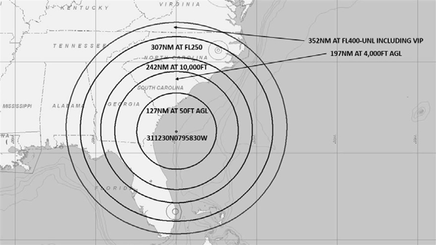
A U.S. Navy exercise in the southeastern United States will involve GPS interference testing that could make aircraft navigation unreliable or unavailable on Aug. 30 and Sept. 5.
The Federal Aviation Administration issued an advisory about the testing, which will be centered in the Atlantic off the coast of Savannah, Georgia, on the SAV VOR 139-degree radial at 84 nautical miles.
It could affect GPS reliability — including WAAS, GBAS and ADS-B — centered at 311230N 0795830W (SAV139084):
within a 352-nautical-mile radius at Flight Level 400
within 307 nautical miles at Flight Level 250
within 242 nautical miles at 10,000 feet
within 197 nautical miles at 4,000 feet above ground level
within a 127-nautical-mile radius at 50 feet above ground level.
The tests are scheduled for 1800 Zulu to 2200 Zulu on Aug. 30, and 1600 Zulu to 2000 Zulu on Sept. 5.
The FAA advisory states that GPS interference notices to airmen may change with little or no notice, and encourages pilots to check regularly for updates. NOTAMs will be published at least 24 hours in advance of any GPS tests.
Ships sailing through the Strait of Hormuz and the Persian Gulf have been experiencing GPS interference that U.S. officials suspect is the work of the Iranians, according to CNN.
The U.S. Department of Transportation’s Maritime Administration issued an advisory on Aug. 7 to ships traveling in the Persian Gulf, Strait of Hormuz, Gulf of Oman, Arabian Sea and Red Sea. Ships have reported GPS interference, bridge-to-bridge communications spoofing and jamming, and other problems.
Iran’s goal is for ships and aircraft to wander into Iranian waters or airspace, justifying a seizure, a U.S. defense official told CNN. He said Iran has placed GPS jammers on Iran-controlled Abu Musa Island, which lies in the Persian Gulf close to the entrance of the Strait of Hormuz.
“Heightened military activity and increased political tensions in this region continue to pose serious threats to commercial vessels,” reads the advisory. “Associated with these threats is a potential for miscalculation or misidentification that could lead to aggressive actions. Vessels operating in the Persian Gulf, Strait of Hormuz, and Gulf of Oman may also encounter GPS interference, bridge-to-bridge communications spoofing, and/or other communications jamming with little to no warning.”
In at least two incidents, vessels reported GPS interference. One vessel reportedly shut off its Automatic Identification System (AIS) before it was seized, complicating response efforts.
Vessels have also reported spoofed bridge-to-bridge communications from unknown entities falsely claiming to be U.S. or coalition warships.
Since May 2019, the following maritime incidents have occurred in this region:
Six attacks against commercial vessels.
Shoot-down of U.S. Navy remotely piloted aircraft over international waters
Attempted at-sea interdiction of Isle of Man-flagged M/V British Heritage (oil tanker)
Seizure of ex-Panama-flagged M/V Riah (oil tanker)
Seizure of U.K.-flagged M/V Stena Impero (oil/chemical tanker)
Detention and subsequent release of Liberian-flagged M/V Mesdar (oil tanker).
On Aug. 10, the National Space-Based Positioning, Navigation, and Timing (PNT) Advisory Board, the government’s GPS expert board, sent a letter to the National Executive Committee for Space-Based PNT (a multi-agency body that steers GPS policy) that concluded, “We strongly recommend your opposition to the Ligado proposal.”
The letter sprang from a unanimous vote five days earlier to oppose allowing Ligado Networks to use spectrum neighboring the GPS band for terrestrial communications.
Ligado possesses licenses to broadcast on two satellite bands located adjacent to the GPS frequencies. The company has been seeking permission from the Federal Communications Commission (FCC) to repurpose these licenses from satellite-based use to ground-based use from powerful tower transmitters.
Ligado said in May it would lower the power in its proposal for the 1526–1536 MHz band to 9.98 dBW to avoid interference with certified aviation receivers. However, the PNT Advisory Board reiterated its opposition, saying that even if the transmissions’ power was lowered to just under 10 watts, it “will create totally unacceptable interference for a great number of GPS users in the United States.”
From the Letter: “This risk is far too great, and far too many questions remain, for Ligado’s proposal to be approved. While there are many broadband alternatives (Ligado would be a very small percentage of this national asset), there is only one GPS. Any impairment to current and future uses is clearly contrary to the national interest. Therefore, implementation of their recently proposed ~10-watt operating scheme will create totally unacceptable interference for a great number of GPS users in the United States. In fact, despite power limits in their current amended application, it is probable they could still be allowed to increase this power over time. This would be even more destructive to GPS users.
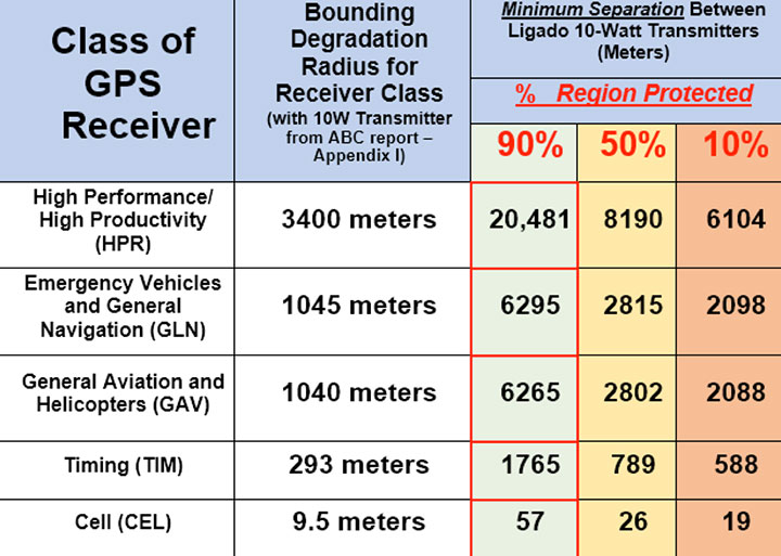
“We believe avoiding degradation over at least 90 percent of the region near Ligado transmitters is the absolute minimum protection for GPS receivers in each class. This would be a hypothetical 90 percent Protection Evaluation. This is not an endorsement of this level since, of course, all users would prefer 100 percent protection. The Department of Transportation (DOT) Adjacent Band Compatibility (ABC) study is the only validated test to verify degradation at various received power levels.
“Those results inform that to insure degradation not exceed 10 percent of the Region (90 percent Protection) for High Performance receivers, either:
Ligado maximum power can be no more than .0036 watts at the 400-meter spacing they had earlier planned. Tolerable power would be 3/10ths of 1 percent of their proposed ~10 watts. Or
the closest spacing of Ligado transmitters is 20,000 meters (over 12 miles) for their proposed ~10 watt power level (see Figure 1).”
Figure 1. The PNTAB strongly believes that 90 percent is the minimum Area Protection Criterion (maximum 10 percent degradation). (Chart: PNT Advisory Board)
The U.S. Defense Advanced Research Projects Agency (DARPA) Microsystems Technology Office is soliciting research proposals for the development of a new class of atom-based systems using integrated photonics and trapped atoms to enable high-performance, robust, portable clocks and gyroscopes.
The military researchers are asking industry to develop relatively simple portable photonic integrated circuits (PICs) for high-performance position, navigation and timing (PNT) devices as an alternative to GPS for when satnav signals are not available.
A PIC or integrated optical circuit, similar to an electronic integrated circuit, integrates multiple photonic (having to do with light) functions, providing capabilities for information signals imposed on optical wavelengths, typically in the visible spectrum or near-infrared, 850–1650 nanometers.
A-PhI Program
The Atomic-Photonic Integration (A-PhI) program seeks to develop trapped-atom based, high-performance PNT devices, reducing the complexity of these atomic systems by using PICs. According to the DARPA document, the PICs will replace the optical assembly behind devices such as sensitive and accurate angle sensors and clocks, while still enabling the necessary trapping, cooling, manipulation and interrogation of atoms.
A-PhI aims to demonstrate that compact PICs can replace the optical bench of conventional free-space optics for high-performance trapped-atom gyroscopes and trapped-atom clocks without degrading the performance of the underlying physics package.
Physics
Atomic systems using trapped atoms have the potential to be made portable while maintaining their accuracy due to the atomic trap’s small size and the inherent isolation a trap offers an atomic system from the environment, especially from acceleration.
Currently, these systems are bulky, heavy, and not notably portable, because of the complexity of the optical systems used to create the trap.
In the past, efforts to miniaturize the hundreds to thousands of optical components in such benchtop systems have relied on removing optical elements, miniaturizing the remaining elements, and tightly integrating them in a small package.
The products deliver degraded performance with the need to maintain very tight optical alignment, causing both poor environmental robustness and poor tolerance to design errors. Effective miniaturized atomic systems cannot be achieved at a reasonable cost with this approach.
Recent developments in PIC research suggest that on-chip optical frequency combs based on microresonators, optical frequency synthesis, novel on-/off-chip coupling, wavelength demultiplexers, and on-chip phased arrays for dynamic manipulation of light fields can replace optical systems with readily manufacturable, low-cost chips without the alignment sensitivity of conventional free-space optics.
Gyroscopes
A-PhI also seeks to develop proof-of-concept trapped atom gyroscopes, a matter-wave analog of the interferometric fiberoptic gyroscope. Such a miniaturization effort could generate an order of magnitude improvement in angular sensitivity and dynamic range over current free-space products.
A-PhI hopes to develop portable, high-performance, navigation and timing systems: the miniaturization of the optics of atomic systems without a decrease in performance. Subsequent work, the RFP asserts, will be required to incorporate the necessary compact and robust lasers and electronics to achieve a fully functioning, high-performance, portable PNT system.
Ligado’s proposed broadband service continues to pose a significant risk of harmful interference to GPS, several key signatories wrote in a July 18 letter to U.S. Federal Communications Commission (FCC) Chairman Ajit Pai.
The interference would occur despite Ligado’s May 31 amendments to its license modification applications, the letter states. “The proposed Ligado operations, even after the recently proposed amendments, will harmfully impact a wide range of GPS receivers and thus should not be permitted.”
Key signatories include representatives of Iridium Communications, the International Air Transport Association, Lockheed Martin, Rockwell Collins and Satelles.
The letter urges the FCC to deny Ligado’s pending license modification application unless Ligado can show it has addressed the substantive GPS interference concerns. Also encompassed in the letter are concerns over interference with satellite communications (SATCOM) and weather data.
“The record, augmented by recent government reports, makes clear that the interference will be particularly impactful to the countless government and commercial entities that rely on GPS and SATCOM services for aviation safety and other critical services,” the signatories wrote.
“A number of data points underscore the flaws in the way in which Ligado has attempted to measure interference to GPS from its proposed terrestrial operations.”
Ligado recently acknowledged that its license modification request as originally filed is insufficient to protect certified aviation GPS receivers, but offered no changes to its proposal to address interference to uncertified GPS systems, SATCOM services (also important for aviation safety), or concerns of the weather data community.
“Evaluating Ligado’s recent amendment to ensure protection of uncertified GPS receivers and protection of GPS receivers from aggregate interference will be necessary,” the letter states.
1-dB Criterion. One issue is the 1-dB degradation interference protection criterion, which Ligado has suggested is “neither accurate nor reliable.” That criterion was used in the U.S. Department of Transportation’s Adjacent Band Compatibility assessment issued in April, which examined the maximum transmitted power levels of adjacent band systems that can be tolerated by GPS receivers. The study endorsed and strictly applied the 1-dB criterion, and termed it the “accepted, worldwide standard for PNT and many other radio communication applications.”
“Each of these government efforts supports one conclusion — the proposed Ligado operations, even after the recently proposed amendments, will harmfully impact a wide range of GPS receivers and thus should not be permitted…
“We urge the Commission to deny Ligado’s pending license modification application as proposed unless Ligado can show it has addressed the substantive GPS, aviation, SATCOM, and weather data interference concerns still outstanding in the record,” the letter concludes.
By Bradford Parkinson Vice-chair, U.S. PNT Advisory Board
In the coming months, the U.S. Federal Communications Commission (FCC) may allow high-powered, ground-based, communication transmitters to broadcast at a frequency near GPS L1. U.S. Department of Transportation (DOT) tests have shown that such transmitters effectively become jammers for many existing GPS receivers.
I believe that this possibility is the greatest current threat to the position, navigation and timing (PNT) community.
L1 is the primary band for GPS as well as for similar GNSS. For example, the international signal called L1C is to be centered at L1, albeit with wider spreading than the current L1 civil signal, C/A.
Why is this of critical importance? An economics study that only considered a small subset of benefits concluded that the U.S. alone realized $65 billion per year in direct economic value. A more complete recent study for the UK, extrapolated to the U.S., estimated the total impact of the loss of GPS to be over $3 billion per day for a five-day outage — a far greater rate. Virtually all GPS applications rely on the signals at L1. Thus, any threat to GPS is not simply an inconvenience, it would have great potential to do economic harm.
The PNT Advisory Board (PNTAB)has been trying to protect PNT, particularly GPS, and at the same time accommodate Ligado, a company that has requested repurposing of nearby spectrum. At our November meeting, we reviewed the Ligado proposal and framed a response that will be made public in due time. Meanwhile, these observations and conclusions are my own.
History
In 2011, LightSquared proposed that existing restrictions on its existing frequency authorization in the Mobile Satellite Service (MSS) band (a faint signal, satellite-to-ground) be waived so that the band is effectively repurposed to allow for high-power terrestrial transmissions.
The company has two space-to-ground authorizations in the 1525–1559 MHz band (1526–1536 MHz and 1545–1555 MHz) very close to the GPS primary frequency (L1 at 1575MHz). Initially it requested repurposing to ground transmission of 42 dBW (15.8 kW).
Faced with tests and analysis that showed this would be very destructive to GPS, it proposed to abandon the closer band and reduce power in the further band to 32 dBW, or 1580 Watts.
Ligado filings suggest a spacing of approximately ¼ mile between transmitters. A GPS receiver would find even these weaker signals 5 billion times the power of GPS at the maximum range of ¼ mile.
Most PNT users would be much closer.
International criterion
To ensure ranging accuracy, the international standard for interference to GPS is a 1-dB increase in noise levels. In conventional terms, this max allowable 1 dB is a 25.8% increase in background noise. The power of the weak GPS signal is only about 1% of the background radio noise. Sophisticated signal processing algorithms allow the signal to be reconstructed.
The result: the international 1-dB standard is equivalent to a 25% reduction in GPS radiated power.
Two additional points
The 1 dB is not simply to protect signal lock, it is to protect ranging accuracy. Most GPS receivers will stay locked for higher levels of interference but lose high precision. This is particularly a problem for high-precision receivers, which need relative timing to sub-nanosecond accuracies.
These measurements are equivalent to the time it takes light to travel ¼ inch. Protecting such accuracies is of paramount importance to PNT users and applications.
Allowing such maximum degradation from a single source is not the whole picture. There are many other potential sources of interference and attenuations of the GPS signal. For example, foliage may reduce the GPS signal.
A receiver must cope with all of these difficulties. Allowing a single cause, such as the Ligado repurposing, the 25.8% equivalent reduction might be considered quite generous, but it is the accepted International Standard.
Ligado has specifically rejected this criterion, largely because testing has shown that the Ligado repurposing would then be unacceptable for many PNT user classes.
To support its rejection of the International Standard, Ligado has repeatedly alleged that five of the major manufacturers are in complete agreement regarding its repurposing. This is a substantial distortion. The record was set straight by Brian Ramsay of MITRE at the November PNTAB meeting: “Four of the five parties that reached agreements with Ligado (except for Topcon Positioning) support the 1-dB Interference Protection Criterion (IPC) in comments filed in response to this Public Notice.”
Further support was highlighted by Captain Robyn Anderson: “In June 2017, the Air Force produced a white paper on the 1-dB IPC that explained the relationship between harmful interference (levels that affect GPS receiver performance) and the 1-dB IPC (keeps interference below a level that would cause harmful interference).”
Lightsquared’s motivation in 2011 was clear: a $10 billion windfall profit (estimated increased value of the spectrum on open-market auction). The FCC did not confirm Lightsquared’s modified request, and in 2012 the company went into bankruptcy.
Reorganizing as Ligado and emerging in December 2015, it continued to pursue repurposing of its spectrum, sponsoring tests by Roberson and Associates, and tests at National Institute of Standards and Technology (NIST)/National Advanced Spectrum and Communications Test Network (NASCTN) to establish test procedures.
Both groups of tests were carefully reviewed by our PNTAB who found serious flaws. In general, Ligado rejected the 1-dB criterion and did not accept the need to protect all classes of users, particularly high-precision receivers. In addition, it did not consider the new GPS L1 signals (L1C and L1M), nor did it check the impacts on the international GNSS. The PNTAB assembled a 14-point summary of deficiencies and requested updates and corrections for the flaws.
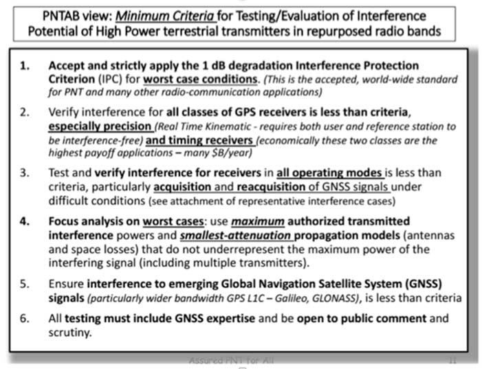
NASCTN’S response did not really address the points, or claimed that there were no funds to correct the problems. The PNTAB then developed a Six-Point Criteria for acceptable interference testing,summarized as:
Accept and strictly apply the 1-dB criterion.
Verify interference for all classes of receivers.
Test and verify for all operating modes.
Focus analysis on worst cases.
Include the new GNSS signals.
Include GNSS expertise and openly publish results.
Image: PNTAB
We believe it is a very reasonable set that aims to protect PNT users and our economic benefits. In its sponsored tests, and in representations to the FCC, Ligado has consistently overlooked a basic facet of radio ranging: it is ranging accuracy, not simply locking onto a signal, that is the fundamental objective for PNT.
Both Ligado test sets clearly failed on all six points.
DOT ABC tests
While the Ligado-sponsored tests were neither independent nor adequate, the Department of Transportation, led by Karen VanDyke, sponsored a very complete set of independent tests; these are the most credible estimates of harmful interference. The ABC results have been made public. The PNTAB’s six points were published after DOT testing had begun, but DOT expanded and modified their effort to satisfy the criteria. The DOT conclusions, based on modeling real-world antennas and propagation patterns, are shown in Table 1.
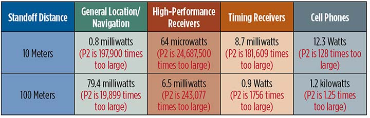
TABLE 1. DOT ABC test results. Maximum tolerable effective radiated power (EIRP) for classes of the most susceptible GPS receivers for modified Ligado proposal (P2) of 1.58 kilowatts. In red are the factors that Ligado P2 exceeds the maximum tolerable radiated power. (Chart: GPS World)
At 100 meters, all classes of receivers tested had results that would exceed the 1-dB threshold, even for the reduced power level (P2, 1580 Watts) that has been the most recent filing. The shaded square is particularly troublesome. It shows that, for the most susceptible high-precision receivers, the Ligado proposed power exceeds the 1-dB threshold by over 200,000. This result is particularly damning for the proposed repurposing, because it is this class that produced the highest payoff in the recent Department of Commerce Study — over $30 billion per year.
PNT operations at risk
These are examples of unintended and potentially hazardous consequences of repurposing.
UAVs. Unmanned aerial vehicles (drones) will fly very close to the dense array of transmitters that Ligado would deploy. They usually require GPS for flight control. Even more important, if we are to monitor them and keep them from collisions, GPS offers the only viable techniques with 3D accuracy and almost 100% availability.
Precision survey. This is routinely used in urban areas for building construction and is a major source of productivity gains. These survey receivers are all high precision and routinely make measurements to better than ¼ inch.
Helicopters. These are found in urban area at all altitudes. They are used for law enforcement, rescue and passenger transportation. GPS is mainly used for general navigation.
Public safety vehicles. Fire, police and ambulances use GPS for both navigation and dispatch tracking. In a city, they would drive in and out of susceptible high-interference zones.
The PNTAB believes the DOT results are representative, accurate and credible. The National Coordinating Office for PNT also sponsored an evaluation of all testing to date. A summary report is now in coordination, as a combined Department of Defense (DOD) and DOT effort.
The DoD, which uses GPS in the national airspace for routine flight, testing, training, guiding rocket launches, and for humanitarian rescue missions, has opposed repurposing. The Air Force reported, “Results from the DOD ABC Assessment support the conclusions drawn from Department of Transportation’s ABC Assessment.”
November PNTAB meeting
At our November meeting, the board invited Ligado to make a presentation on its repurposing proposal. The invitation said: “Specifically describe your implementation plan, with a corresponding test plan addressing the issues we have openly raised. We request you specifically focus on those regarding the potential for interfering with any GPS/GNSS services that operate in the protected space-to-Earth L-band (1559–1610 MHz). Included should be all modes of operation and the use of all current and future GNSS signals.”
Valerie Green, executive vice president and chief legal officer of Ligado Networks, represented Ligado. In the run-up to the meeting, the Six-Point Criteria had been sent to Ligado. Green did not address the six points at all.
She did offer to reduce initial power to “the safe power level in the 1526–1536 MHz channel ranges from 9 to 13 dBW EIRP nationwide,not just near airports.”
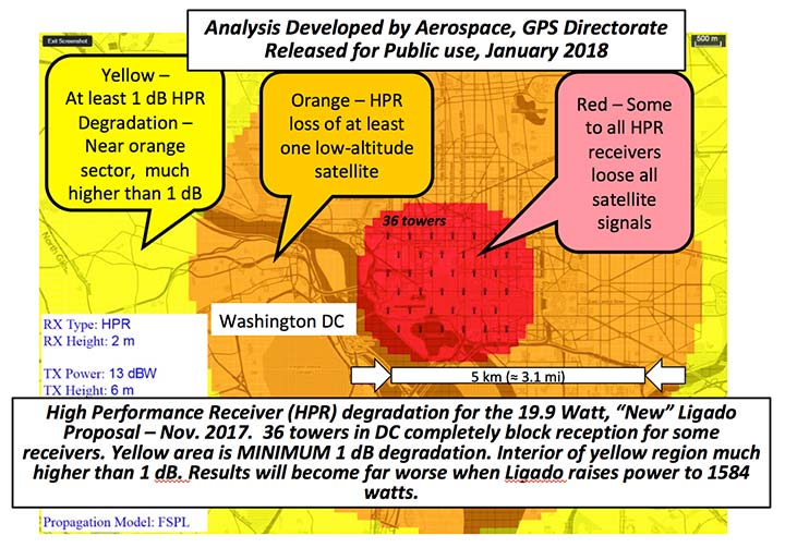
FIGURE 1. Potential impacts on high-performance receivers. Red: loss of lock of all satellites. Yellow: loss of lock of low-elevation satellites. Green: 1-dB degradation. (Chart: PNTAB)
The 13 dBW corresponds to initial power levels of 19.95 W. However, Ligado has made clear in its FCC filings that it ultimately still wants a full 32 dBW base-station transmit power level, consistent with typical 4G/LTE networks.
The initial reduced power sounds like a major move in the right direction, but further questioning revealed two major issues:
Tower Spacing. Green was very evasive on the spacing of transmitter towers. Clearly, at the reduced power level, greater density would be needed to carry the original data bandwidth. At about 1/100th the power, density would have to increase by a factor of 100, and the spacing would have to decrease to 1/10th for the same data output rate.
Green referred us to an earlier filing which specified 0.25 mile, but did not clearly state that this was the plan; she claimed the details were proprietary. If this fundamental parameter, spacing, is not specified, it is hard to see the basis for the FCC evaluation of any new proposal. If the transmitter spacing is reduced to less than 1/10th of a mile, the sources of potential harm would be multiplied in a very worrisome way.
Future power constraint.A public presentation does not ensure that Ligado will actually file and agree to abide by those power constraints indefinitely. Board members pressed Green on the permanence of the power constraint.
She suggested it would be tied to the RTCA Minimum Operational Performance Standard. Revising the MOPS takes many years, if not decades, both to formulate and to implement. Retrofitting the commercial aircraft fleet is very expensive and time-consuming.
Further, her statement focuses only on commercial aircraft, ignoring the high-precision classes as well as future signals.
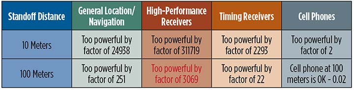
A modified summary chart (Table 2) for the lower power, based on the DOT ABC test results, shows that even at the lower power, the threshold for high-precision receivers is exceeded by a factor of over 3,000 at 100 meters. In fact, only cell phones, which are relatively inaccurate, could operate at 100 meters without exceeding the threshold.
TABLE 2. Results of DOT ABC test with Ligado transmitters constrained to 19.95 Watts (13 dBW). This illustrates that the International Interference Limit is exceeded many times over at 100 meters for certain high-precision receivers, highlighted in red. (Table: GPS World)
With these expectations and uncertainties, the PNTAB did not find the new revision acceptable to the PNT community.
Three fundamental issues
Ligado has steadfastly not accepted the realities of non-interference.
1 dB. Acceptance of the 1-dB (25.8% noise increase) International Interference standard is fundamental to protecting GPS applications throughout the country.
All current and future uses. Users of great concern are emergency services, helicopter and general aviation, UAVs, and precision survey and machine control. For example, many of the underground utilities in the U.S. have been mapped with precision, GPS-based, geographic information receivers. This application requires sub-meter accuracy and operates in both rural and urban environments.
Ligado has tended to simply focus on certified aviation, claiming that protecting that class of user is enough. The PNT community rejects that view. All current and future PNT users must be protected.
Worst–case interference. The recent round of testing was largely in a laboratory. Extrapolating to the real world must examine the situations with greatest interference. For example:
Number of simultaneous interfering transmitters. A single transmitter situation is not typical; three or more are apt to be in range. The additive power must be considered.
Propagation models. Propagation models for communications differ from those for evaluating potential interference to a navigation signal. For assured communication, a typical model assumes transmitted signal fall-off a little faster than 1/(distance squared). Ligado would naturally prefer to use this model, which is far from worst-case for interference. The early round of tests in Las Vegas verified the communications model would vastly underestimate interference levels, by factors of 10 or more. A more realistic model must be used.
Degradation Radius. This is the size of the circle within which the International Standard is violated for receivers in a specified class. If the spacing of transmitters is 400 meters, and the degradation radius is 200 meters, virtually all receivers are in the degradation zone. Ligado suggested an appropriate degradation radius is 250 feet for aviation (approximately 100 meters). Thus, they claim the PNT community should tolerate violation of the standard when closer than 100 meters to their transmitters. At 400 meters spacing, 25% of the area would be in violation.
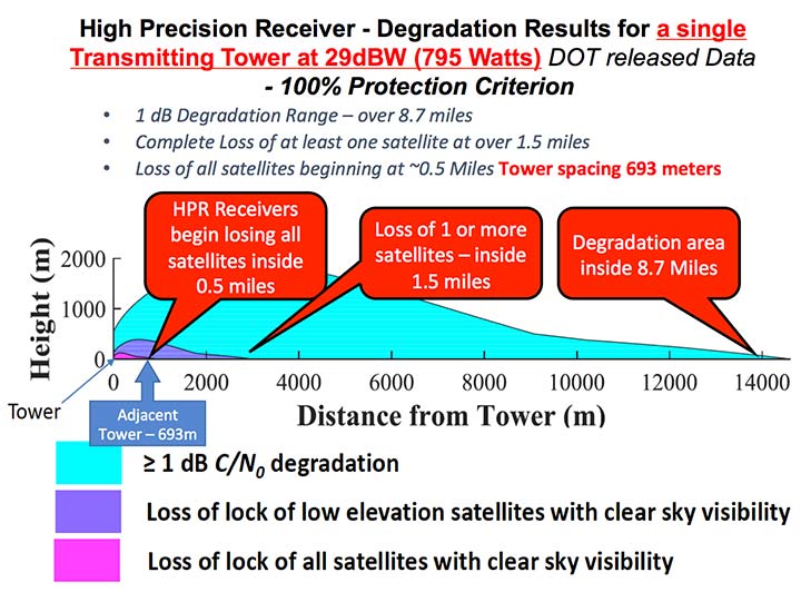
But the ABC test results reveal a much graver situation. They show that, for the current Ligado proposal (1580 watts), the degradation radius is over 14 kilometers for high-precision receivers. See Figure 2.
The 1-dB criterion is the correct, accepted and somewhat generous allocation of interference that can be accepted by the PNT community. We would hope that the FCC would continue to insist on this standard.
PNT users must, yet again, defend the spectrum vigorously. Most of us are scientific and technical people. We are not used to discussions that deliberately avoid the technical issue or deny scientific evidence. We reject arguments that violate the fundamental laws of physics.
The currently filed proposal, 1580 Watts at spacing of ¼ mile, is unacceptable. It will do grave harm to many important PNT applications
We must be very leery of the new proposal by Ligado of 9–13 dBW. It still would violate the 1-dB criterion at 100 meters for many PNT users.
Moreover, the company history has been to bait and switch; it has an authorization for MSS Ancillary Terrestrial Component (MSS ATC) stations to fill the gaps in satellite coverage with ground transmitters. These must operate in conjunction with the space-to-ground link that made them effectively self-limiting. However, in 2011, it almost succeeded in switching this to a ground-only system, which would have achieved a huge financial windfall.
Open-air verification
If the FCC continues to consider this proposal, there is one step that it should take before granting it. It should require Ligado to deploy an array of transmitters in its advocated configuration, and run real-world, open-sky testing to assess the harm that may result, particularly to high-precision accuracy.
Such testing was done when the issue was first raised in 2011 and conclusively demonstrated unacceptable interference. Nothing has really changed from the baseline that was tested and found unacceptable then.
The company should carry the full financial burden of such a verification, under PNT supervision. The government, having already spent millions of dollars to defend the spectrum, should not bear the cost of such retesting.
Without this confirmation, it is hard to conceive of putting GPS and PNT at significant risk to satisfy investors who want to flip a company, after gaining “rezoning” permission for their spectrum.
From 20,000 feet altitude
If we examine the situation without the technical details, we have this: Fundamentally Ligado wants to provide service using its allocated frequency band for an unlimited number of Internet-of-Things installations.
It is not proposing a small, fixed number of transmitting towers located in isolated regions, but rather an accelerating deployment of private networks, many of which will be close to commercial and essential infrastructure where GPS use is critical.
It seems unrealistic that Ligado can or will reliably guarantee that these widespread installations will be continually adjusted and monitored to avoid GPS interference.
I believe the concept of allowing the installation of transmitting towers that, by design, will interfere with normal GPS use at some distance away opens the door to tacit approval of short-range (or not-so-short-range) GPS jammers.
While I can commend the entrepreneurial spirit, the Ligado proposal seems very reckless indeed. The incremental value of an additional broadband transmitting system when there are at least five already in existence seems trivial compared to the potential damage done to the modern utility named GPS.
I sincerely hope the FCC can find a spectrum swap or deny outright the current Ligado application.
Ligado Networks will appear and present at the National Space-Based Positioning, Navigation and Timing Advisory Board’s (PNTAB) meeting on Nov. 15 in Southern California.
Ligado and its predecessors have sought to install high-powered ground transmitters that have been shown to harm and overwhelm GPS signals and receivers in their general vicinity. The controversy has simmered for at least eight years without resolution.
That final resolution will ultimately be taken by the Federal Communications Commission (FCC), although congressional participation is also conceivable, since national infrastructure security is involved.
Meeting Locale. The PNTAB meeting will take place Wednesday, November 15, 2017, 9:00 a.m. to 5:00 p.m.; and Thursday, Nov. 16, 9 a.m. to 1 p.m., at the Crowne Plaza Redondo Beach & Marina Hotel, 300 North Harbor Drive, Redondo Beach, California, approximately a half hour’s drive south of Los Angeles International Airport. The meeting will be open to the public up to the seating capacity of the room. Visitors will be requested to sign a visitor’s register.
From June 28, 2017, PNTAB presentation by Brad Parkinson.
The central issue in this long-running fight is the as-yet unknown — though uniformly predicted by the various rounds of testing over the last eight years — effects of Ligado signals on a huge installed industrial and governmental base of GPS receivers, some of which are essential to the nation’s critical infrastructure.
Ligado Networks, the current-day incarnation of once-bankrupt LightSquared, seeks FCC permission to apply the satellite-based frequency licenses it owns to be broadcast from a ground-based network. This would put a powerful nearby signal immediately adjacent to the much weaker, more distantly emanating GPS signals, and by the way, those from other GNSS as well. Tests in 2011 and further testing in 2016 demonstrated these powerful signals interfering with GPS receivers.
Brad Parkinson
The Ligado appearance comes in response to an open letter, posted on Oct. 10 by PNTAB First Vice-Chair Brad Parkinson, inviting Ligado CEO Doug Smith to speak to the Advisory Board. That invitation itself emerged after a season of what have been termed “attack” statements issued in various forums by Ligado, which were in turn stimulated by two early-summer letters:
1. A June 27 letter from the American Geophysical Union, Aerospace Industries Association, American Meteorological Society, Aircraft Owners and Pilot s Association, Airlines for America, General Aviation Manufacturers Association, International Air Transport Association, Iridium Communications, Thales USA and other organizations (totaling 22) to the FCC opposing Ligado’s request.
“The undersigned organizations . . . write to reiterate that the threat of harmful interference from Ligado’s proposed ancillary terrestrial component (“ATC”) service remain real and persistent. Contra ry to the assertions in Ligado’s FCC advocacy and recent media blitz, its proposed terrestrial operations continue to pose a significant interference risk to numerous parties . . . . The risks to these critical services are very real and, consistent with the public interest, cannot be brushed aside.
That letter further notes that “Ligado seeks the ability to sell its spectrum to the highest bidder, underscoring the uncertainty of any prospective value of the services it has on previous occasions suggested it may provide. There is a clear effort by Ligado to downplay the significance of the technical concerns it continues to receive from numerous directions.”
2. A July 5 letter from the PNT Advisory Board to Deputy Secretary of Defense Robert O. Work and Deputy Secretary of Transportation Jeffrey A. Rosen, the co-chairs of the National Executive Committee for Space‐based Positioning, strongly opposing the Ligado proposal.
From June 28, 2017, PNTAB presentation by Brad Parkinson.
“The revised [Ligado] proposal to the FCC is fundamentally unchanged from a previous proposal reviewed in 2011. Extensive government testing in 2011 and in 2016, clearly shows that both proposals cause definitive harmful interference to many classes of GPS receivers.”
“All GPS stakeholders should be wary of any incremental approaches to deploying mobile broadband services in the mobile satellite systems (MSS) band. For example, initial services could operate at reduced power levels on a temporary basis to protect only a subset of GPS users, before moving to full — power levels that will cause widespread interference to many other classes of GPS users. Regulatory decisions must be based on the ultimate end-state of any systems proposed for operation in the bands adjacent to GPS, and must protect all classes of GPS users. Unfortunately, the latest industry proposal does not acknowledge the legitimacy of, and the need to protect, dozens of precise applications of great national importance.”
From June 28, 2017, PNTAB presentation by Brad Parkinson.
Round Two. The struggle has been a prolonged one, with many twists and turns, however coalescing into two main periods of activity:
2011-12, when the first round of tests showed then-LightSquared’s proposed network would overload the vast majority of GPS receivers. The Federal Communications Commission (FCC) tabled the proposal, and the company, holding spectrum licenses whose value could range far into the billions of dollars, filed for bankruptcy.
2016–18. LightSquared emerged from Chapter 11 in 2015 as Ligado Networks, positing a modified network plan, but one whose organizing concept remains unchanged, causing deep and continued alarm over GPS interference. 2017 tests, conducted by a firm and a government organization hired by Ligado, essentially reconfirmed the 2011 results. The tests found that the proposed ground towers would significantly interfere with GPS receivers as far away as 4 to 5 kilometers, “killing them dead” in the words of one expert who reviewed the test data.
Parkinson’s October 10 letter invites Ligado CEO Doug Scott “to provide the committee with clear up-to-date design information. . . . How might the system as now envisioned be deployed? How many ground terminals are needed, for example, and where would they be?”
Previous LightSquared and Ligado presentations have been long on promise but short on details. In fact, sound technical underpinning has not been communicated.
From June 28, 2017, PNTAB presentation by Brad Parkinson.
Parkinson writes “we would therefore encourage you to specifically describe your implementation plan , with a corresponding test plan address ing the issues we have openly raised . We request you specifically focus on those regarding the potential for interfering with any GPS /GNSS services that operate in the protected Space – to – Earth L band (1559 – 1610 MHz) . Included should be all modes of operation and the use of all current and future GNSS sign als. Without these specific technical details and corresponding evaluations, we can only conjecture as to what you are really proposing .”
Later, he affirms “our focus is to provide advice based on deep engineering and related expertise . As you know, interference to GPS/GNSS can adversely affect numerous safety – of – life systems , other vital national assets, and applications comprising over $60 billion of annual U.S. productivity benefits .”
Parkinson and the PNTAB have had better luck securing a Ligado appearance than did GPS World magazine. In August of this year, Ligado’s senior vice president and chief engineer for radio access technologies thrice declined an invitation to give a brief Expert Opinion for the September issue on the question: How can the safety, security, and full utility of GNSS applications be ensured while evolving best, most efficient use of limited, very valuable electromagnetic spectrum?
Just a Refresher. The PNTAB meeting will be held Wednesday, November 15, 2017, 9:00 a.m. to 5:00 p.m.; and Thursday, November 16, 2017, 9:00 a.m. to 1:00 p.m., at the Crowne Plaza Redondo Beach & Marina Hotel, 300 North Harbor Drive, Redondo Beach, CA, approximately a half hour’s drive south of Los Angeles International Airport. The meeting will be open to the public up to the seating capacity of the room. Visitors will be requested to sign a visitor’s register.
Ligado is by no means the only item on the Committee’s docket, but is very likely to be the pièce de résistance. The full agenda for the meeting includes:
Update on U.S. Space-Based Positioning, Navigation and Timing (PNT) Policy and Global Positioning System (GPS) modernization.
Prioritize current and planned GPS capabilities and services while assessing future PNT architecture alternatives with a focus on affordability.
Examine methods in which to Protect, Toughen, and Augment (PTA) access to GPS/Global Navigation Satellite Systems (GNSS) services in key domains for multiple user sectors.
Assess economic impacts of GPS/GNSS on the United States and in select international regions, with a consideration towards effects of potential PNT service disruptions if radio spectrum interference is introduced.
Review the potential benefits, perceived vulnerabilities, and any proposed regulatory constraints to accessing foreign Radio Navigation Satellite Service (RNSS) signals in the United States and subsequent impacts on multi-GNSS receiver markets.
Explore opportunities for enhancing the interoperability of GPS with other emerging international GNSS.
Examine emerging trends and requirements for PNT services in U.S. and international fora through PNT Board technical assessments, including back-up services for terrestrial, maritime, aviation, and space users.
The U.S. Coast Guard issued a safety alert on Jan. 16, warning mariners of the potential detrimental impact to navigation caused by GPS interference or jamming. The warning emphasizes the importance of understanding how vessel equipment could be impacted by the loss of a GPS signal.
The Coast Guard states that this past summer, multiple outbound vessels from a non-U.S. port suddenly lost GPS signal reception. The net effect was various alarms and a loss of GPS input to the ship’s surface search radar, gyro units and ECDIS, resulting in no GPS data for position fixing, radar over ground speed inputs, gyro speed input and loss of collision avoidance capabilities on the radar display.
Fortunately, the vessels were able to safely continue theirvoyage using radar in heads up display, magnetic compass and terrestrial navigation. Approximately six nautical miles later, the vessels’ GPS units resumed operation. Although the vessels had back-up systems to allow a safe transit, the consequences could have been severe, warns the Coast Guard.
Full content of the alert appears below.
Global Navigation Satellite Systems – Trust, But Verify Report Disruptions Immediately
Do you know what equipment relies upon the U.S. Global Positioning System (GPS) signal? How would you respond if you lost the signal? This past summer, multiple outbound vessels from a non-U.S. port suddenly lost GPS signal reception. The net effect was various alarms and a loss of GPS input to the ship’s surface search radar, gyro units and Electronic Chart Display & Information System (ECDIS), resulting in no GPS data for position fixing, radar over ground speed inputs, gyro speed input and loss of collision avoidance capabilities on the radar display. Fortunately, the vessels were able to safely continue their voyage using radar in heads up display, magnetic compass and terrestrial navigation. Approximately 6nm later, the vessels’ GPS units resumed operation. Although the vessels had back-up systems to allow a safe transit, the consequences could have been severe. These types of events highlight the potential detrimental impact to navigation caused by GPS interference or jamming and the importance in understanding how your vessel’s or facility’s equipment could be impacted by a loss of GPS signal.
Whether walking through the city, driving across town or navigating the world, Global Navigation Satellite Systems (GNSS) have become an integral part of everyday life. However, at times, the positioning signals may be impacted by interference from both natural and human-made sources. The most common types of interference are reception issues, usually due to bad installations, poor antenna positioning or faulty equipment. Jamming devices, while illegal in the U.S. and a threat to safety, have been used for nefarious or deceptive purposes. Interference can also be unintentionally caused when operating GNSS in close proximity to other radiating devices, such as amplified TV antennas (see our Safety Alert 11-02). Therefore, it is important to remember to use all available means for navigation and maintain proficiency so you can still navigate should your primary GPS fail.
Indicators of positioning systems interference include an intermittent signal, no signal, or an incorrect signal. Suspected or suspicious disruptions should be reported immediately. Critical information to take note of during a disruption event includes location, time, and period of outage.
Commercial operators are reminded, should your navigation or other equipment onboard (e.g. AIS) be impaired as a result of a disruption or interference, this should be reported to the nearest U.S. Coast Guard Captain of the Port, District Commander or Vessel Traffic Center as soon as possible; and, await further directions (per 33 CFR 164.53).
All operators should be aware, vigilant, and immediately report GPS disruptions to the U.S. Coast Guard Navigation Center (NAVCEN). The report will be disseminated to the U.S. Air Force GPS Operations Center and the Federal Aviation Administration in an attempt to identify the problem and correlate with any other GPS incidents in the same general geographic location. Depending on the severity of the report, NAVCEN may refer it to law enforcement and/or other federal agencies for further investigation.
Reporting a disruption — or other navigation hazards or aids to navigation outages — is simple, and can be done electronically (http://www.navcen.uscg.gov, the preferred method) or via phone call to the NAVCEN (703- 313-5900), 24 hours a day.
Wavelet Packet Decomposition (WPD) shows promise as an anti-jamming tool.
The WPD is derived from the wavelet transform, which provides a representation of the signal components in a domain spanned by a set of functions that can be seen as band-pass filters with a bandwidth decreasing as their central frequency increases, thus granting a uniform resolution in the decomposition of the signal under analysis.
A paper by Luciano Musumeci and Fabio Dovis of Politecnico di Torino and James T. Curran of the Joint European Commission’s Research Center, titled “A Comparative Analysis of Adaptive Notch Filtering and Wavelet Mitigation against Jammers Interference,” won the Best Paper in Session award in GNSS Vulnerabilities and Anti-Jamming at the ION-GNSS+ 2015 conference.
The paper compares two interference mitigation techniques at the digital signal processing level for jamming signal removal.
The authors compare the traditional adaptive notch filtering scheme, widely discussed in scientific literature, with a new technique based on the use of the WPD. Both techniques are implemented in software, and their performance has been assessed via the use of a fully software GNSS receiver. Both techniques are first applied to a set of simulated GNSS jammed scenarios.
Preliminary results demonstrate that a significant improvement is achieved at both acquisition and tracking level when the WPD algorithm is employed with respect to the application of the classical adaptive notch filtering. In fact, using the adaptive notch filtering, the effective range of the jamming can be reduced from approximately 474 meters up to 127 meters, while when using the WPD-based algorithm, such a range can be further reduced up to approximately 10 meters. These results are also confirmed by successive test campaigns where performance comparison of both software implemented techniques is assessed considering simulated GNSS data.
The WPD-based technique is characterized by a higher computational complexity with respect to the implementation of notch filtering. This is mainly caused by the several filtering operations needed for the time-scale representation computation. Therefore, the number of decomposition stages and the filter length need to be carefully traded off with the jamming detection and removal capability of such a technique.
However, the availability of a high-performing processor together with a jamming detection based on spectral estimation can potentially lead to a faster WPD computation for future real-time applications.
The Defense Advanced Research Projects Agency (DARPA) is holding a Proposers Day on Feb. 1 to inform potential contractors about the Atomic Clock with Enhanced Stability (ACES) program.
ACES is a potential $50 million program that seeks to develop battery-powered atomic clocks that work to provide warfighters with synchronization and precision timing capabilities during navigation, communications, electronic warfare and reconnaissance missions in the event of a GPS shutdown.
The registration deadline for the Proposers Day is 5 p.m. EST on Jan. 25. The Proposers Day will be held Feb. 1 from 9:30 a.m. to 5 p.m. EST at the DARPA Conference Center, 675 N. Randolph Street, Arlington, Virginia 22203.
The host is Robert Lutwak, ACES program manager at DARPA. In 2012, GPS World awarded Lutwak its Leadership Award for Products.
The meeting will provide information and promote additional discussion on the ACES program, address questions from potential proposers, and provide an opportunity for potential proposers to share their capabilities and ideas for teaming arrangements.
The ACES Proposers Day will include overview presentations by government personnel, technical presentations by potential proposers and collaborators, and an open poster session to facilitate interaction and teaming.
According to the Department of Defense (DoD), “Precision timing and synchronization is essential to DoD communications, navigation, reconnaissance, and electronic warfare systems. The requirements for timing precision and stability have grown increasingly demanding as DoD systems have evolved towards distributed engagement and surveillance architectures, and this trend is expected to continue for the foreseeable future.
“The ACES program aims to develop portable, battery‐powered atomic clocks with stability, repeatability, and environmental sensitivity approaching that of laboratory‐grade cesium beam frequency standards. This will be accomplished through research, development and integration of reduced SWaP components and technologies for advanced atomic physics interrogation techniques. These include, but are not limited to, laser‐cooled and magneto‐optically trapped atomic samples, and RF‐trapped ion samples, as well as interrogation of less environmentally‐sensitive microwave and optical transitions.”
eLoran Antenna Park of 13, 200-meter masts at Anthorn, UK.
Readers of GPS World, its e-newsletters, website — and all interested PNT parties — are invited to register their opinion in the current poll at gpsworld.com/janpoll.
Should the U.S. government install a full eLoran network of broadcast stations to back up GPS in case of jamming, interference or other emergencies?
Yes.
No.
More study is needed before answering this question.
Don’t know.
Voters may enter their name in a drawing to receive a $50 gift card. Vote by Jan. 11, 2016.
Results will be published in the February issue of GPS World magazine.