Tag: GPS interference

  • Helpful techniques to mitigate the effect of GPS jamming and spoofing

    Helpful techniques to mitigate the effect of GPS jamming and spoofing

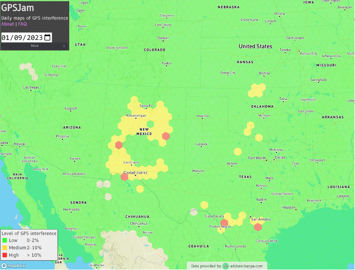
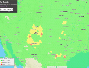
    U.S. Department of Transportation (DOT) figures show incidences of GPS signal interference, such as jamming and spoofing, have increased significantly in both North America and much of Western Europe. Both commercial and military operations are affected, and ADS-B reports from Zurich University of Applied Sciences (ZHAW) cite up to 700 global GPS spoofing and jamming incidents taking place daily.

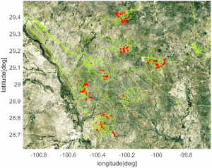
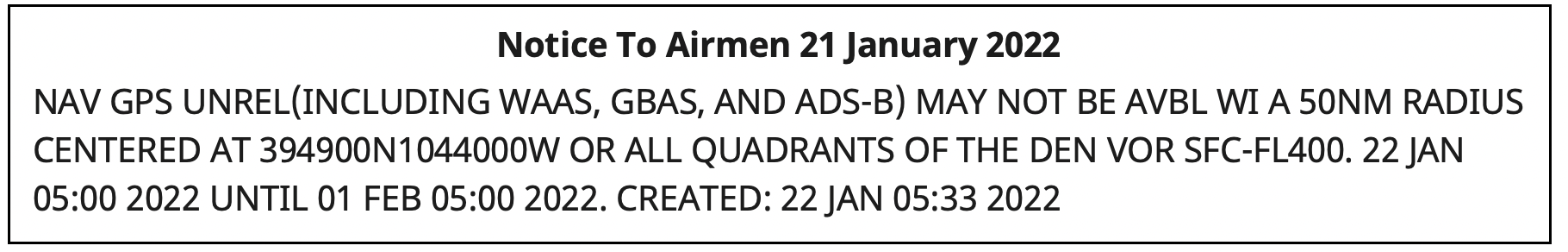
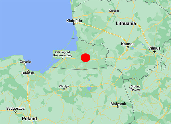
    Events are particularly concentrated around war zones, with Lithuanian airspace alone recording more than 300 cases of GPS interference in March. The consequences have ranged from emergency diversions of civilian aircraft to, in at least one case, the downing of an aircraft. Other sectors reliant on precise timing and geolocation, such as communications and emergency services, also are being impacted.

    Of course, it’s not just navigation; and a swath of industries rely on PNT signals. This includes secure and regulatory-compliant financial transactions, power grid synchronization, asset tracking, ensuring data integrity and coordinating workloads across global telecommunications and artificial intelligence (AI) servers.

    How can PNT systems be made more resilient to this interference? What emerging technologies enable PNT systems to maintain operational capability in GPS/GNSS-denied, degraded or disrupted space operational environments (D3SOE)?

    Interference Techniques

    GPS interference comes in a wide variety of forms, and systems are susceptible because the signals from the satellites are faint by the time they reach the Earth.

    Jamming is a brute force denial of service (DoS) attack, with a device transmitting a signal on the same L1 (1575 MHz), L2 (1227 MHz) or other relevant bands as the PNT satellites. Being nearer and stronger, these signals drown out the GPS information and prevent the ability to calculate a position, simply making GPS services unavailable.

    Conversely, spoofing is a more sophisticated technique that mimics the structure of an authentic satellite signal but transmits falsified timing and positioning data. Similar to jamming, this relies on the spoofed signal being closer and more powerful than the legitimate PNT transmission and can either trick the navigation system into believing it is suddenly in a different position, or alter it slowly over time causing, for example, a ship or aircraft to deviate into an unsafe location.

    These DoS and deception techniques are the major classes, but in addition to natural and accidental man-made sources, there also are multiple variations on spoofing techniques and methodologies:

    Meaconing: Rebroadcasting of an authentic signal with a delay and shift in position to affect navigation systems.

    Replay attacks: Like meaconing, but more targeted to financial transactions, fooling GPS-based time-stamping systems into accepting fraudulent transactions.

    Data-level manipulation: Where false orbital data, clock corrections and GPS time is given in addition to the location data. These tend to be harder to detect and cause slow changes. They also can be applied to systems that rely on precise timing, such as financial networks and power grids.

    PNT Resilience

    PNT resilience standards are set out in the draft IEEE P1952 standard, which specifies technical requirements and expected behaviors for resilient PNT user equipment.

    End users can test five behavior levels, which are defined within this standard to enable users to select a level that is appropriate based on their risk tolerance, budget and application criticality.

    Photo: PNT Resilience Levels
    Photo: PNT Resilience Levels

    Level 1 represents a basic ability to detect interference such as jamming, spoofing, or other disruptions, and alert users. Level 2 enables equipment to automatically recover to normal operation when the disruption is no longer present. In level 3, the equipment can maintain acceptable performance during the disruption. This capability is fortified in level 4 by leveraging multiple diverse sources or advanced mitigation techniques. Finally, level 5 enables the equipment to verify that the time or PNT information received is accurate.

    Here in the U.S., the NIST 8323.1 Cybersecurity Framework for PNT also offers a comprehensive approach to assessing and mitigating PNT-specific cybersecurity risks. The DHS’ Resilient PNT Conformance Framework and CISA Federal PNT Services Acquisition Guidance are additionally important.

    Countering Jamming

    Traditional PNT systems are struggling to keep pace and meeting IEEE P1952 to tackle GPS interference requires a sophisticated, multi-source zero-trust architecture that never trusts, always verifies and authenticates, and goes beyond simple signal reception. For mission-critical systems, not only do threats need to be detected, but incoming data need to be validated and alternative sources for PNT incorporated, all within an intelligent sensor fusion system.

    If we look first at the DoS jamming technique, here the issue is an inability to detect the medium-Earth orbit (MEO) GPS/GNSS signal in the presence of another more powerful signal.

    It is possible, however, to reinforce L-band communications from GPS satellites, and look to stronger signals, notably from low-Earth orbit (LEO) satellites. While these have less accuracy for timing (GPS/GNSS: <15 ns vs 80 ns for LEO), they are significantly stronger (the Iridium LEO STL signal is 1000x stronger than GNSS) and are more resistant to jamming.

    Countering Spoofing

    In spoofing, the use of encrypted signals is vital.

    GPS signals are open, unencrypted and should not be trusted blindly, and the use of alternative cryptographically secured alternatives is essential to ensure the signal’s origin is legitimate. For example, this is implemented on both the Inmarsat GEO and Iridium LEO satellites used in VIAVI’s SecurePNT and SecureTime services.

    Sensor fusion also should be implemented to combine PNT data with information coming from onboard sensors such as inertial measurement units (IMUs) to identify inconsistencies — not just sudden large jumps but continual slight deviations.

    Beyond these, navigation message authentication can be implemented, using a public key to verify the satellite-broadcast signature and prove the location, clock corrections and status being transmitted. This is already implemented by Europe’s Galileo Open Service Navigation Message Authentication (OSNMA) and makes it very difficult to data-level spoof these satellites.

    While using receiver autonomous integrity monitoring (RAIM) techniques, calculate position with redundant satellites, excluding one satellite each time to check for consistency of results. ARAIM (advanced RAIM) uses the same technique, but applies it to multiple constellations, for example, GPS and Galileo.

    Signal liveliness/consistency checks can be particularly effective against meaconing and replay attacks. These techniques examine the Doppler shift of the signal, with satellites having predictable and specific profiles that will differ significantly when compared to a ground-transmitted signal, which will have a near-zero Doppler shift.

    Operating Under D3SOE

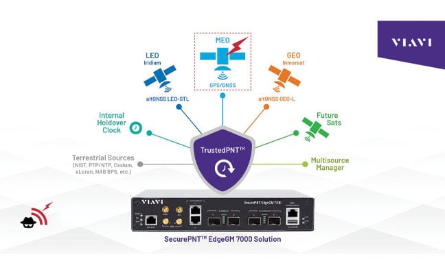
    The above is a summary of the types of techniques that underpin VIAVI’s SecurePNT and SecureTime services.

    SecureTime eGNSS GEO uses an encrypted L-band signal, transmitted from Inmarsat’s GEO satellites to create an enhanced timing service with GNSS authentication and anti-spoofing capabilities and provides sub-5 ns timing accuracy when installed on SecurePNT products.

    Conversely, the SecurePNT systems implement multi-source receivers for GNSS backup and multi-band GNSS with GEO-L for outdoor antennas. The PTP grandmaster uses the latest sub-microsecond accuracy PTP protocol and the traditional millisecond range accuracy Network Time Protocol (NTP) to be compatible with virtually all standard IT equipment — also implementing high-speed 25G PTP Ethernet for connection to high-performance AI data center and AI-RAN networks and financial exchanges without creating bottlenecks.

    Terrestrial sources, such as a network PTP feed and an optional atomic caesium clock, also can be used for synchronization to increase resilience in the event of a prolonged GPS outage. Nino De Falcis is an experienced business development leader with a strong background in the Global PNT market. Currently serving as the senior director of Global PNT Business Development at VIAVI Solutions since January 2024, he focuses on accelerating global business development and identifying growth opportunities.

  • Royal Navy trials quantum navigation systems with University of Sussex

    Royal Navy trials quantum navigation systems with University of Sussex

    The UK Royal Navy‘s Disruptive Capabilities and Technologies Office (DCTO) recently teamed up with scientists from the University of Sussex to test new navigation sensors developed to reduce reliance on GPS navigation.

    The ultra-sensitive quantum sensors measure tiny variations in the Earth’s magnetic field, offering a new way to pinpoint locations when satellite signals are jammed or unavailable.

    “We are excited and pleased to have supported this first sea trial with the University of Sussex and its quantum magnetometer technology,” said Commander Matt Steele, from DCTO. “We are also grateful to our colleagues in the Hydrographic Exploitation Group for providing one of its vessels and crew to provide a test platform.

    “To ensure it can resiliently operate in GNSS-denied and degraded environments, the Royal Navy continues to explore and accelerate the development of alternative means of navigation, such as this magnetic sensor, while positioning itself as a pioneer ‘quantum-enhanced navy’.”

    “GPS or GNSS signals are highly vulnerable to disruption: they can be jammed or spoofed, and they fail entirely underground, underwater, or in heavily obstructed environments,” said Tom Coussens, Research Fellow in Quantum Science and Technology at the University of Sussex. “This vulnerability has serious economic and operational consequences. While alternative systems such as inertial navigation and visual recognition exist, none simultaneously meet all critical requirements: long-term positional accuracy, weather independence, and resistance to jamming.”

    In the trials, a team from the university worked with the Royal Navy’s Hydrographic Exploitation Group who survey waters, recording details of depth, seabed objects and composition. The university used its Optically Pumped Magnetometers in open waters, with the trials taking place from His Majesty’s Naval Base Portsmouth.

    In addition to navigation, they also successfully mapped surrounding magnetic signatures, pointing to new methods for detecting vessels, undersea features, and potential hazards.

  • One GPS Mystery Solved, Another Remains

    One GPS Mystery Solved, Another Remains

    Ever since it came on-line in February 2022, the website GPSJam.org has shown what appears to be regular interference with GPS signals in Texas near San Antonio and Del Rio, and locations north and south of Oklahoma City, Oklahoma.

    Only on normal workdays, however. Not on weekends or holidays. Furthermore, whatever was happening also took time off between the Christmas and New Year holidays GPSJam.org also shows similar, though less regular, activity in New Mexico. Experts say this is easily explained as White Sands Missile Range is often the site of electronic warfare training and tests. These are always announced in advance in FAA Notices to Air Missions (NOTAMs) when any interference with GPS reception is anticipated.

    The regular patterns observed in Texas and Oklahoma and the lack of NOTAMs led some experts to speculate the source could be inadvertent interference from a commercial or government activity. Said one former official, “It’s just the kind of pattern you see from large organizations. They are off every weekend, federal holidays, and around Christmas.”

    Aerobatic-capable Military Training aircraft reporting low NIC values (Image: Stanford University)
    Aerobatic-capable Military Training aircraft reporting low NIC values (Image: Stanford University)

    GPSJam.org is the brainchild of aviation analyst John Wiseman. The site uses crowdsourced ADS-B reports gathered by the ADS-B Exchange and displays it on a world map. Areas in yellow indicate that between two and ten percent of ADS-B reports for the day had low navigation accuracy. Areas in red had ten percent or more.

    Information from the site has proved useful in identifying patterns of regular GPS jamming and spoofing in Russia and other conflict areas around the globe.
    The workday patterns in Texas and Oklahoma have appeared on GPSJam.org displays since the site went live in February 2022.

    GPS Interference and Aviation

    Minor interference with GPS signals is fairly common. GPS jamming devices, while illegal to use, are inexpensive and easy to obtain from vendors on the internet.

    Truck drivers wanting to defeat their company’s fleet tracking system, people concerned about being tracked by the government or others, even ministers trying to keep parishioners from texting during sermons – all have been known to use such devices.

    Most GPS interference is unintentional. A two-year European Union study found hundreds of thousands of potentially harmful signals, but judged only about ten percent to be intentional. The rest were the inadvertent byproduct of poorly tuned electrical and electronic equipment.

    ADS-B tracks of training aircraft performing aerobatics. Red indicates low NIC value reported. (Image: Stanford University)
    ADS-B tracks of training aircraft performing aerobatics. Red indicates low NIC value reported. (Image: Stanford University)

    While most GPS interference is unintentional and localized, spurious signals powerful enough to noticeably impact airborne operations are not unknown.

    In two separate incidents last year strong interference near the Denver and Dallas airports impacted air traffic, each for more than a day. The Denver incident lasted for 33 hours before authorities found the source and shut it down. Air traffic was disrupted at Dallas for 44 hours according to government sources, though researchers found the actual interference only lasted for 24 hours. The source of the disruption was never identified.

    In 2019 a passenger aircraft was almost lost due to GPS interference while on approach to Sun Valley, Idaho’s Friedman Memorial Airport. As the aircraft flew a GPS-based approach in smoke and haze, the interfering signal was just strong enough to lure it off course and toward a mountain. Fortunately, a sharp-eyed radar controller hundreds of miles away spotted the problem and intervened in time. The source of the interference was never identified.

    As a result of the Sun Valley incident and input from numerous aviation groups, the International Civil Aviation Organization told its members there was an “urgent need to address harmful interferences” to satnav signals.

    Texas and Oklahoma Mystery Solved

    A researcher at Stanford University finally solved the puzzle of the strange recurring sequence of reports from Texas and Oklahoma.

    While investigating last October’s GPS interference event near the Dallas airport, PhD candidate Zixi Liu noticed aircraft outside the main area of effect also reporting low Navigation Integrity Category (NIC) values. This began before and continued after complaints from commercial airlines about GPS not being available at Dallas-Fort Worth. These aircraft were in the same general area of Texas, but far enough away that there were large areas between them and Dallas that did not contain any reports with low NIC values.

    Low navigation accuracy reports displayed at GPSJam.org. in New Mexico reports were due to GPS interference from military testing. In Texas and Oklahoma, military aerobatics training likely caused reports of low navigation accuracy. (Image: GPSJam.org)
    Low navigation accuracy reports displayed at GPSJam.org. in New Mexico reports were due to GPS interference from military testing. In Texas and Oklahoma, military aerobatics training likely caused reports of low navigation accuracy. (Image: GPSJam.org)

    At the same time MS Liu was also investigating anomalous ADS-B reports near San Antonio and Del Rio, Texas. She discovered in all three cases the reports of low NIC values were coming from military training aircraft regularly used for aerobatics. Other aircraft nearby reported good NIC values and showed no evidence interference.

    In a recent presentation to the Institute of Navigation, she postulated that Interference with GPS signals was not the cause of the low navigation integrity reports. Rather, the rapid maneuvers and unusual aircraft attitudes of aerobatics caused the airplanes’ navigation receivers to intermittently lose lock on signals from GPS satellites. This caused their ADS-B equipment to report low navigation integrity.

    Having solved that mystery, Ms. Liu continues to work on her original question – identifying the source of October’s 24-hour GPS disruption near the Dallas-Fort Worth airport.

    Mr. Dana A. Goward is the President of the Resilient Navigation and Timing Foundation and a former US Coast Guard helicopter pilot.

  • GPS interference harms the economy, national security and everyday people

    GPS interference harms the economy, national security and everyday people

    GPS relies on faint radio signals from satellites about 12,000 miles away, requiring a quiet spectrum neighborhood to operate. (Photo: NASA)
    GPS relies on faint radio signals from satellites about 12,000 miles away, requiring a quiet spectrum neighborhood to operate. (Photo: NASA)

    By Alex Damato
    Acting Executive Director
    GPS Innovation Alliance

    From its humble beginnings in the 1970s to its expanded use in the present day, GPS technology has been vital for nearly every industry from defense and aviation to farming and construction. GPS devices are designed to receive faint GPS signals transmitted from satellites about 12,000 miles away. Acknowledging this reality, regulators have historically maintained for GPS, which relies on such faint radio signals and sensitive equipment, an appropriately quiet spectrum neighborhood—populated by similar users.


    With the NASEM report’s confirmation of harmful interference, the deficiencies of the FCC’s April 2020 decision are even more striking


    Although these GPS signals and equipment have benefitted from decades of optimization, it is impractical to place highly sensitive GPS receivers designed to capture faint signals from remote transmission facilities immediately next to high-power communications equipment. Unlike those from communications systems, GPS signals are below the thermal noise floor when they are received. As a result, increases in that noise floor often decrease the availability of GPS services, which in turn places at risk high-consequence and safety-of-life services that rely on GPS.

    Alex Damato
    Alex Damato

    Why does this matter? In April 2020, the FCC approved a plan to deploy a terrestrial network in spectrum adjacent to the frequency bands used by GPS — operating communications signals that would be around two billion times more powerful than GPS signals at the same location.

    This past September, the National Academies of Sciences, Engineering, and Medicine (NASEM) released a report detailing the harmful effects of a terrestrial communications network that would operate in a frequency band close to that of GPS.

    Expert concern within 14 federal agencies and departments, a broad coalition in Congress, and the GPS industry resulted in a congressional mandate that NASEM conduct an independent technical review of potential interference to GPS. After a thorough review of the materials, NASEM concluded that the proposed terrestrial network would result in harmful interference to a substantial number of GPS receivers.

    In particular, the report noted that high precision GPS devices, which are used in the most economically significant GPS applications, are the most vulnerable receiver class and likely to be affected by interference. The potential for any interference with GPS, especially with devices used by the Department of Defense, poses a threat to national security, the economy, and our daily lives.

    With the NASEM report’s confirmation of harmful interference, the deficiencies of the FCC’s April 2020 decision are even more striking: potentially millions of farmers, pilots, construction companies, and first responders may be required to repair or replace GPS equipment at their own cost. Although the FCC assumed that this equipment could be repaired through upgrades or filters, some devices cannot be filtered without significant financial and performance costs, and some devices simply cannot be filtered at all.

    GPS is estimated to provide up to $300 billion annually in benefits to the economy. Any disruption in GPS accuracy and usage would have detrimental effects on productivity and economic growth. Moreover, the year before the FCC’s flawed decision, another key report revealed that the loss of GPS service would have an average impact of $1 billion per-day on the nation.

    The GPS Innovation Alliance will continue to work with all federal and industry stakeholders to maintain open channels of communication to connect, listen, and learn from all those involved in the discussion. As technological innovation continues, these debates on harmful interference are not going away, and GPSIA is looking forward to engaging further.

  • The Ligado saga continues

    The Ligado saga continues

    Matteo Luccio
    Matteo Luccio

    The LightSquared/Ligado Networks saga, now in its second decade, continues. On Sept. 9, the Committee to Review FCC Order 20-48 Authorizing Operation of a Terrestrial Radio Network Near the GPS Frequency Bands of the National Academies of Sciences, Engineering and Medicine (NASEM) released its consensus study. Both sides claim the report supports their position.

    A summary of the report and reactions from various stakeholders can be found here.

    According to Ligado, the report confirms the FCC’s finding that the company’s operations “can co-exist with GPS.” It cited the report’s conclusion that “the technology to enable compatibility has been in use for over a decade, and most consumer equipment, commercial general navigation, timing, cellular and aviation receivers will not experience harmful interference from Ligado’s operations.”

    The NASEM report also confirmed, the company said, the FCC’s finding that “[a] small percentage of very old and poorly designed GPS devices may require upgrading.” Ligado reaffirmed its commitment to “upgrade or replace” federal equipment negatively impacted by its operations and expressed its hope that now the Department of Defense (DOD) and the National Telecommunications and Information Administration “will stop blocking Ligado’s license authority and focus instead on working with Ligado to resolve potential impacts relating to all DOD systems.”

    By contrast, the GPS Innovation Alliance applauded the NASEM’s “reaffirmation that Ligado’s terrestrial operations would have a harmful, real-world impact on the millions of federal and commercial users that rely on GPS, satellite communications, and weather forecasting services every single day.” It further stated that the report “demonstrates that Ligado would pose an unacceptable risk to services critical to safety-of-life operations, our national security, and our economy” and urged “government action to address the imminent, but preventable, harm that would result from Ligado’s deployment.”

    According to the DOD, the NASEM study “confirms that Ligado’s system will interfere with DOD GPS receivers, which include high-precision GPS receivers.” The study also concludes, DOD says, that the FCC’s proposed mitigation and replacement measures “are impractical, cost prohibitive, and possibly ineffective.”

    The NASEM committee pointed out repeatedly in its report that matters are more nuanced than represented by either side and that test results and harmful interference depend on many factors — including the receiver’s signal processing architecture, the amount of SNR loss, the use case, and the relevant failure modes. “The determination of harmful interference is dependent on the particulars,” it said.

    The committee also bemoaned “a lack of a quantifiable definition of harmful interference” and “the lack of common receiver assumptions” and called for “more definitive receiver standards.” It also pointed out that “many spectrum conflicts could be avoided if receivers were better designed and implemented.”

    The GPS user base is in the billions. Therefore, even if “most” receivers will not be harmed by Ligado’s operations, as the committee reported, tens of millions of devices will be. I highly recommend reading the full report.

  • What happened to GPS in Denver?

    What happened to GPS in Denver?

    Photo: YayaErnst/iStock/Getty Images Plus/Getty Images
    Photo: YayaErnst/iStock/Getty Images Plus/Getty Images

    Something big happened to GPS service in the Denver area on Jan. 21.
    Photo:
    On that day, Air Traffic Control issued a notice advising pilots of problems with GPS reception spanning about 8,000 square miles in the Denver area.

    The advisory, posted at 10:33 p.m. Denver time, said GPS was unreliable within a 50-nautical-mile radius of the Denver International Airport. Interference was likely to be experienced by aircraft on the ground and as high as 40,000 feet above sea level.

    The advisory also said the Wide Area Augmentation System (WAAS) and Ground-Based Augmentation System (GBAS), both designed to make navigation with GPS more precise, as well as the ADS-B collision avoidance and traffic management system, would be unreliable.

    Pilots reported other systems affected such as transponders that help radar controllers keep track of aircraft, traffic alert and collision avoidance (TCAS) equipment, autopilots, electronic flight bags and terrain warning systems.

    Pilots trying to land at Denver International and the much small Centennial Airport 20 miles to the south reported a variety of problems.

    From the social media platform Reddit:

    I flew in there (Centennial Airport) last night and I’m about to fly out. One second everything was fine, and then next second we completely lost GPS for the rest of the flight, probably coming through ~14,000 [feet] on the arrival from the northwest.

    In addition to verbal reports to air traffic controllers, formal reports were filed with NASA’s Aviation Safety Reporting System (ASRS) by pilots flying into Denver International. (Note that ASRS only lists the month reports were submitted, not the day, to preserve anonymity.) Nineteen ASRS reports about GPS in Denver during January match well with comments on Reddit and an Airliners.net forum for the 21st and 22nd of the month.

    The ASRS reports tended to focus on problems during approaches to the airport and landings. The most minor included distracting cockpit alerts and warnings.

    Cleared ECAM (Electronic Centralized Aircraft Monitor) and emergency cancelled the repetitive nuisance messages. Additionally, received a GPS Lost message on FMC [Flight Management Computer].

    More concerning were incidents that could more directly impact safety of flight.

    One aircraft’s collision avoidance system, which normally reports issues as they develop, abruptly directed action to avoid another aircraft.

    …we received a “LEVEL OFF” TCAS RA with no prior notification. The offending target was to our 2-3 o’clock and climbing…

    Two aircraft reported confusing navigation displays on final approach to the airport. One pilot flying in limited visibility (instrument conditions) was sufficiently concerned that they aborted a landing attempt at the last minute.

    We were about 1000 AGL [1,000 ft above ground level] – not sure about the exact altitude – and our RA [anti-collision warning] turned into an amber color… We were about 300 – 200 AGL and our autopilot failed… It was very unexpected… I called the go-around.

    So, what happened to GPS?

    At first, Air Traffic Control told pilots 5G telecommunications systems were causing the interference. That stopped at some point, though, according to an online comment:

    As a [air traffic] controller… they haven’t told us anything. I was at work when it all started yesterday and they told us to make broadcasts about 5G interference. Today, they said it wasn’t 5G and not to make those broadcasts, but they still haven’t said what the issue is. There’s obviously rumors and speculation, but at this point, nothing concrete.

    The first mention of the incident in traditional media seems to have been in an August 2022 journal article by a group of researchers at Stanford University. It focused on using the aviation ADS-B system to geo-locate GPS interference. The U.S. Department of Transportation provided the exact location and signal strength of Denver’s interfering transmitter to assist the Stanford study.

    Requests in August and early September to the departments of Transportation, Homeland Security and Defense for more information on the incident went unanswered.

    The picture became a bit clearer, though, on the second day of the Civil GPS Service Interface Committee (CGSIC) held (coincidentally) in Denver.

    Mike Roskind from the Department of Homeland Security (DHS) provided some information and promised a formal report would be forthcoming. He said:

    • the incident lasted for 33.5 hours
    • impacts varied across infrastructures and applications; some users who were physically shielded from the interference source were able to maintain service
    • wireline and cellular providers had timing backup systems and were unaffected
    • a radio system with no backups suffered, as did a simulcast radio system that used rubidium backup clocks; the clocks drifted away from each other over the course of the outage and caused towers to isolate.

    Responding to a question about the source of the interference, Roskind confirmed that 5G telecommunication was not the cause, but refused to say more.

    He also declined to identify other systems, applications and infrastructure impacted by the disruption. He said that the department is very concerned about protecting the identity of affected users cooperating with the government analysis.

    More information will be provided in a DHS report on the incident titled “GPS Interference Happens.” The report is in final review now, according to Roskind, and is expected to be released in October.

  • As launch looms, threat from Ligado returns

    As launch looms, threat from Ligado returns

    Matteo Luccio
    Luccio

    “The new LightSquared business plan and the new FCC rules significantly expand the terrestrial transmission increasing the potential for interference to GPS receivers,” the U.S. departments of Defense and Transportation (DOD and DOT) wrote to the Federal Communications Commission in 2011 after the FCC granted the company permission to offer broadband via its satellite and base station networks to a wide variety of mobile broadband partners. The move — heralded by supporters as hastening the advent of 4G services across the country, especially in underserved communities — sent shockwaves across the GNSS/PNT community, which opposed the plan forcefully for the threat it posed to GPS.

    Reborn in December 2015 as Ligado Networks, the company obtained the FCC’s unanimous approval in April 2020 for the use of spectrum near the L-bands used by GPS for its 5G network. It is scheduled to launch its first deployment at the end of September.

    Nearly all the federal government, including DOD and DOT, as well as most manufacturers of GNSS receivers, are very strongly opposed. On September 9, the National Academies of Science, Engineering and Medicine’s Committee to Review FCC Order 20-48 will release its independent evaluation of the issue, as mandated by the 2021 National Defense Authorization Act.

    The study, begun in May 2021, considered three issues:

    1. Which of two prevailing proposed approaches for evaluating harmful interference is most effective to mitigate the risk of harm.

    2. The potential for harmful interference from Ligado to mobile satellite services — such as Iridium.

    3. The feasibility and practicality of the remedies proposed by the FCC.

    A summary of the report can be found here.

    Welcome Penny Axelrad

    I am very pleased to announce that Prof. Penina “Penny” Axelrad has joined GPS World’s Editorial Advisory Board.
    Penny is a University of Colorado (CU) Distinguished Professor in the Ann and HJ Smead Department of Aerospace Engineering Sciences. She received her B.S. and M.S. degrees in Aeronautical and Astronautical Engineering from MIT and her Ph.D. in Aeronautics and Astronautics from Stanford University. She has been a member of the faculty at CU since 1992, serving as primary advisor for 25 Ph.D. graduates and many M.S. and undergraduate research students.

    Penny has been active in research on GPS and PNT technology and applications for aircraft, spacecraft and remote sensing, as well as estimation of satellite orbits and attitude, since 1985, co-authoring more than 60 journal papers and 130 conference papers. She has served as principal investigator or co-investigator on grants and contracts totaling $17 million. She is a Fellow of the Institute of Navigation and the American Institute of Aeronautics and Astronautics, and a member of the National Academy of Engineering. Since 2013 she has served as a member of the National Space-Based Positioning, Navigation and Timing (PNT) Advisory Board.

    I overlapped with Penny at MIT in the mid-1980s. Now, nearly 40 years later, I look forward to her contributions to this magazine.

  • BAE unveils advanced M-code receiver at ION Joint Navigation Conference

    BAE unveils advanced M-code receiver at ION Joint Navigation Conference

    New M-code GPS receiver enables precision strike capabilities in contested environments

    Image: BAE Systems
    Image: BAE Systems

    BAE Systems unveiled its newest advanced M-Code GPS receiver for guided weapons and other small applications at the ION Joint Navigation Conference, taking place this week in San Diego.

    The Strategic Anti-jam Beamforming Receiver – M-Code (SABR-M) enables precise geolocation and strike capabilities in highly contested battlespaces. It delivers accurate position, velocity, altitude and timing data, as well as strong protection against GPS signal jamming and spoofing – critical capabilities for unmanned aerial vehicles (UAVs), precision-guided munitions (PGMs), and missiles in threat environments.

    SABR-M integrates receiver technology with advanced antenna electronics in a small, hardened package designed to meet challenging performance requirements, such as weapons applications. It is the most capable integrated anti-jam GPS receiver and the first integrated M-Code receiver available for weapon systems, according to BAE Systems.

    “We’re making our full portfolio of military GPS solutions M-code-compatible to meet warfighters’ need for reliable positioning, navigation, and timing data to achieve their missions,” said Doug Lloyd, director of weapon systems GPS at BAE Systems. “SABR-M enables small platforms with challenging environmental conditions to get where they’re going despite interference.”

    The compact (4.5 x 6 x 1 inch) SABR-M meets size, weight, power, cost (SWaP-C) and thermal requirements for space-constrained military applications. It uses advanced beamforming technology to improve GPS signal reception and counter threat signals. SABR-M is form-compatible with previous generations of the field-proven SABR receiver, which are integrated on low-cost precision weapon systems and long-range cruise strike missiles.

    SABR-M will be fully qualified for production by the end of 2022. Production will take place at BAE Systems’ modern facility in Cedar Rapids, Iowa, which is in the final stages of construction. The purpose-built 278,000-square-foot factory and research center will be home to 700 military GPS experts in BAE Systems’ Navigation and Sensor Systems business.

  • Septentrio showcases solutions for GPS jamming and spoofing

    Septentrio showcases solutions for GPS jamming and spoofing

    Septentrio will demonstrate how simple it is to spoof or jam unprotected GPS receivers at the upcoming ION Joint Navigation Conference, which takes place June 6-9 in San Diego. The company will showcase how its resilient technology makes a difference for overall security and availability of positioning, navigation and timing (PNT) .

    Photo: Septentrio
    The AsteRx-U3 receiver. (Photo: Septentrio)

    Septentrio will hold a GPS spoofing demonstration, as well as a detailed comparison of jamming solutions from various high-end receivers. The integration of the latest anti-spoofing authentication mechanism, Galileo’s Open Service Navigation Message Authentication (OSNMA), will also be shown.

    “With our growing dependence on GPS technology, resilience of PNT is an important point of attention, especially for mission-critical applications, tactical ground or aerial vehicles as well as autonomous systems,” said Gustavo Lopez, market access manager, Septentrio. “Since the number of malicious jamming and spoofing attacks is on the rise, it is crucial to understand how various GPS receivers can be affected. We are pleased to explain and display this with specific examples at JNC this year.”

    Advance Interference Mitigation (AIM+) is an interconnected set of sophisticated anti-jamming and anti-spoofing technology components, securing GPS/GNSS receivers against various forms of interference.

    AIM+ is an interconnected set of anti-jamming and anti-spoofing technology components comprising a robust defense system against various forms of GPS/GNSS interference. Such resilience to jamming combined with anti-spoofing measures ensures the safety of autonomous machines, improves the security of GNSS-based infrastructure, and increases efficiency with extended PNT availability.

    OSNMA anti-spoofing authentication from Galileo is available on Septentrio receivers such as the mosaic module as well as the recently released AsteRx-U3 boxed receiver. Other products such as AsteRx-SBi3 also add inertial sensors for increased protection against spoofing.

    Septentrio will be at booth 220 in the ION JNC exhibit hall.

  • HawkEye 360 tech reveals early GPS interference in Ukraine

    HawkEye 360 tech reveals early GPS interference in Ukraine

    Technology from HawkEye 360 Inc. has detected and geolocated extensive GPS interference over Ukraine, starting months before the Russian invasion. HawkEye 360 uses satellites to monitor radio-frequency signals that might threaten military and civil navigation applications.

    The capability was tested in 2021 in a variety of exercises and is available as part of HawkEye 360’s RFGeo signal product catalog.

    When HawkEye 360 analysts examined Ukraine over the past five months, they discovered continued and increased GPS interference across the region. The data showed extensive GPS interference in November 2021 along the boundary of the pro-Russian separatist-controlled regions in Luhansk and Donetsk.

    Open-source information confirmed unmanned aerial vehicles (UAVs) operating in the area were disrupted because of lost GPS connections.

    In February 2022, HawkEye 360 detected GPS interference along the border between Ukraine and Belarus, shortly before the Russian invasion started. This February activity occurred north of Chernobyl within the Chernobyl Exclusion Zone, demonstrating the integration of electronic warfare tactics into Russian military operation to further degrade Ukraine’s ability for self-defense.

    “GPS is a fundamental ‘global commons’ service that all modern economies depend upon. GPS signal interference has the potential to significantly disrupt air travel, logistics, finance, transportation, communication and many other basic services,” said John Serafini, CEO of HawkEye 360.

    “Whether unintentional or deliberate, interference that prevents people, vehicles, ships, and planes from determining accurate locations can be devastating to government and commercial activities alike,” Serafini said. “Since HawkEye 360 can monitor hundreds of millions of square kilometers daily, we are able to notify clients when and where GPS interference occurs, so they can respond quickly to mitigate the impacts.”

    Interference can be inadvertent by equipment operating too close to GPS frequency bands. However, deliberate interference has spiked across the globe due to the low cost, ease of deployment, and general availability of GPS jamming technology.

    Military forces use GPS jammers to obscure and protect critical troops, facilities and equipment from attack and can be a leading indicator of future military activity. Drug cartels use GPS jammers to deter surveillance from overhead drones. Use of jammers is illegal in most developed nations.

    HawkEye 360’s detection product offers a valuable capability to monitor for illicit and unintentional GPS interference that can significantly disrupt critical location services, representing the company’s global commitment to make the world a safer place, the company said.

    Image: Hawkeye 360
    Image: HawkEye 360

  • Finnish airline finds GPS interference near Russian border

    Finnish airline finds GPS interference near Russian border

    Photo: william87/ iStock editorial/Getty Images Plus/Getty Images
    Photo: william87/ iStock editorial/Getty Images Plus/Getty Images

    Finnair planes flying close to the Russian border near and south of Finland are reporting unusual activity with their GPS receivers in the last few days.

    No cause for the abnormalities has been determined, but the vicinity to the Russian border during the Ukraine war seems to indicate intentional interference. In particular, interference occurs near the Russian province of Kaliningrad situated between Lithuania and Poland, both NATO members.


    An aircraft operated by Lithuanian carrier Transaviabaltika has been unable to fly from Tallinn to Savonlinna for three days.


    Traficom, the Finnish Transport and Communications Agency, has received numerous occurrence reports regarding GPS signal interference observed by aircraft. The interference began during the weekend and is still continuing.

    On Tuesday, several aircraft reported GPS signal interference in the region around Mikkeli, Jyväskylä and Kuopio. An aircraft operated by Lithuanian carrier Transaviabaltika has been unable to fly from Tallinn to Savonlinna for three days.

    Kaliningrad is the capital of the Russian province of the same name, sandwiched between Poland and Lithuania along the Baltic Coast. (Map: Google)
    Kaliningrad is the capital of the Russian province of the same name, sandwiched between Poland and Lithuania along the Baltic Coast. (Map: Google)

    After receiving reports about GPS interference, Traficom on Monday requested Fintraffic Air Navigation Services Ltd (Fintraffic ANS) to issue a Notice to Airmen for pilots flying in the area.

    “Flying is still safe. Airlines have procedures they follow if the GPS signal is lost,” said Director Jari Pöntinen. “Aircraft can use other systems to navigate and land safely. Air traffic control supports aircraft pilots with the help of other landing systems.” For final approach, traditional approach systems do not require a GPS signal.

    Airlines make their own decisions on whether they can operate in an area where there is known to be interference to the GPS signal.

    Traficom does not know what is causing the interference, but stated it will continue to monitor the situation and gather more information on the matter.

  • US agencies tangle on possible C-band interference

    US agencies tangle on possible C-band interference

    Photo: guvendemir/E+/Getty Images
    Radio altimeters are critical in aircraft landing systems. (Getty image). (Photo: guvendemir/E+/Getty Images)

    As most GNSS industry insiders already know, the Federal Communications Commission (FCC) has licensed adjacent GNSS L1 protection frequencies to Ligado Networks (formerly Lightsquared) for its nationwide 4G-LTE network.

    Many objections emerged as expected this second time around from government agencies, industries and U.S. forces — yet the roll-out is still underway, pending actual interference occurring. This all in an attempt to find communications bandwidth for many emerging commercial radio applications.

    Now, as 5G C-Band 3.7–3.98 GHz wireless phone networks begin their FCC approved roll-out, the Federal Aviation Administration (FAA) has apparently lodged an unanticipated objection on the grounds that cross-interference could compromise aircraft radar altimeter and wireless communications that operate at 4.2 to 4.4 GHz in the C-band.

    While 5G wireless has already been operating in many parts of the world without reports of interference with aircraft systems, the FAA appears to be taking a more conservative approach to how aviation in the United States should co-exist with the new 5G phone wireless system. The FAA has proposed imposing an exclusion zone around airports for 5G wireless networks — which apparently have already been operating with reduced power in these areas — until cooperative operation has been proven.

    Now along comes a new C-band wireless network (SkyLink) aimed at providing high-integrity unmanned aircraft systems (UAS) command and control (C2). The SkyLink company uAvionix has also developed a C-band Control & Non-Payload Communications (CNPC) radio for UAS applications.

    Together with Thales, uAvionics recently tested its radio with its SkyLink radio network. The network has been qualified in accordance with the RTCA DO-377 standard for a network management system that monitors network and radio link health, and the radio has been developed to the draft FAA Technical Standard Order (TSO) C-213A to support critical UAS operations.

    The network uses new DO-362A-compliant SkyLink C-band radios, integrates certifiable aviation-grade hardware and software, uses frequency agility, and provides critical fault monitoring and control capability. The objective is to obviate the loss of the C2 link with the vehicle, and thereby enable beyond-visual-line-of-sight (BVLOS) operations without an FAA waiver.


    It’s unclear whether the emergence of the C-band network — approved by both the FAA and FCC — will play a role in the current phone network interoperability issue. However, uAvionix reports that several sites in the United States and offshore are either rolling out C-band SkyLink networks or evaluating doing so.

    • North Dakota already has an ISM-band SkyLink network at its UAS test site that will shortly transition to C-band.
    • The Choctaw Nation in Oklahoma under an FAA program seeks to enable BVLOS operations through a C-band C2 network.
    • New Mexico State University will use a Skylink C2 network around Las Cruces airport for small UAS (sUAS) operations and testing to overcome anticipated interference from nearby Air Force and Space Force operations.
    • The Tillamook UAS test range in Oregon has already installed the first ground site of a SkyLink network.
    • The University of Alaska at the Fairbanks UAS test site will use uAvionics radios for testing large, heavy UAS operations.
    • In Canada near the Jonesburg airport, a Skylink C2 network will support the safety case for BVLOS pipeline inspection operations for the oil industry.

    While many of these new networks are not yet fully online, the use of frequency hopping, safety-monitored C-band, and certifiable transmissions for UAS command and control appears to be moving forward rapidly. Because the FAA is supporting this testing phase, it seems inevitable that large-scale C-band network rollout for UAS C2 will happen eventually.

    5G phone networks, wireless UAS command and control, and aircraft safety systems essential for landing will need to find a way to co-exist and provide reliable, sustained service to their respective customer bases. Look for much more to develop in this ongoing tussle between industry groups and agencies who appear to have little in common, other than grudgingly sharing a crowded radio spectrum.

    Tony Murfin
    GNSS Aerospace