Rx Networks, Inc., a mobile location technology and services company, today announced a new z-axis determination capability called Zed. This new solution, comprised of a client software library and associated cloud-based data services, is targeted at chipset vendors, device OEMs and application developers seeking to integrate reliable floor-level detection. The announcement came at ION GNSS 2013 in Nashville, Tennessee.
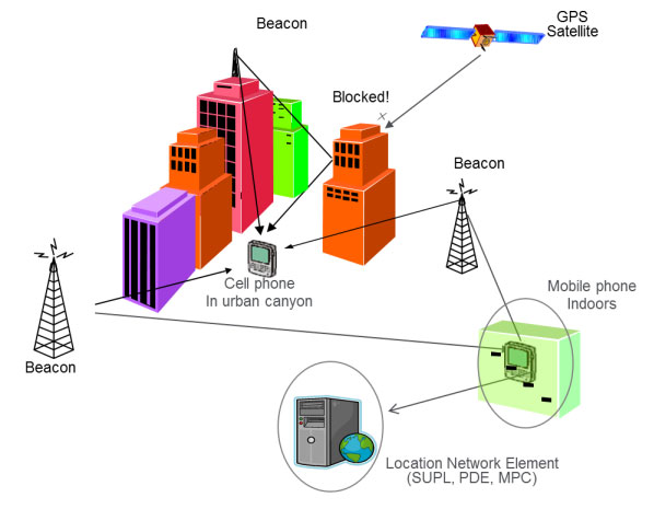
Whether for emergency or consumer applications, the determination of a mobile device’s vertical position while indoors presents unique challenges. Given the environment, even when a GNSS receiver attains a fix, a mobile device cannot reliably use the reported altitude. Beacon-based techniques, such as those derived from Wi-Fi or Bluetooth, remain challenging as they often rely on GNSS-based crowd sourcing or costly venue characterization. The built-in barometric pressure sensors in recent smartphones bring a new ability to estimate altitude, but they have unique and variable characteristics that prevent floor-level accuracy without further assistance.
Rx Networks’ new Zed solution combines accurate geo-reference barometric pressure data (from Custom Weather, a global provider of real-time weather information), automatic device characterization, and pressure crowdsourcing along with existing location services to determine a device’s altitude within 1 to 3 meters.
The Zed solution will be commercially available at the start of 2014 and will be available either on its own, or as an optional feature alongside Rx Networks’ GPStream Assisted-GNSS and XYBRID hybrid location solutions.
For more information a demonstration of Zed, visit Rx Networks booth at ION GNSS+ 2013.
Loctronix Corporation, a provider of unified positioning solutions for GNSS-challenged environments, is making available its new software-defined radio (SDR) module, the ASR-2300, for developing high-performance positioning, navigation and timing, and communication applications.
The ASR-2300 will be on display September 16-19 at the Institute of Navigation annual meeting, ION GNSS+ 2013, in Nashville, Tennessee.
“The ASR-2300 delivers advanced SDR capabilities in a small, mobile form-factor enabling developers to readily create and field complex SDR-based solutions. The module moves SDR out of the lab and into production, providing the critical piece for tapping advanced, multi-sensor/signals of opportunity for high-performance PNT,” stated Michael Mathews, Loctronix’ CEO and founder.
According to Mathews, “The ASR-2300 is unique amongst the growing number of SDRs, having multiple, fully-integrated RF paths supporting reception of GNSS, cellular, ISM band, and UHF signals of opportunity. The ASR-2300 will benefit SDR developers working on demanding scientific, military, aerospace and commercial/industrial applications.”
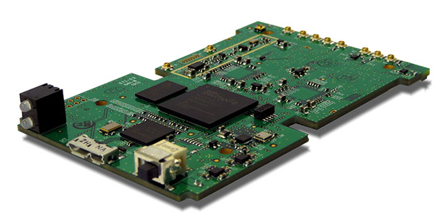
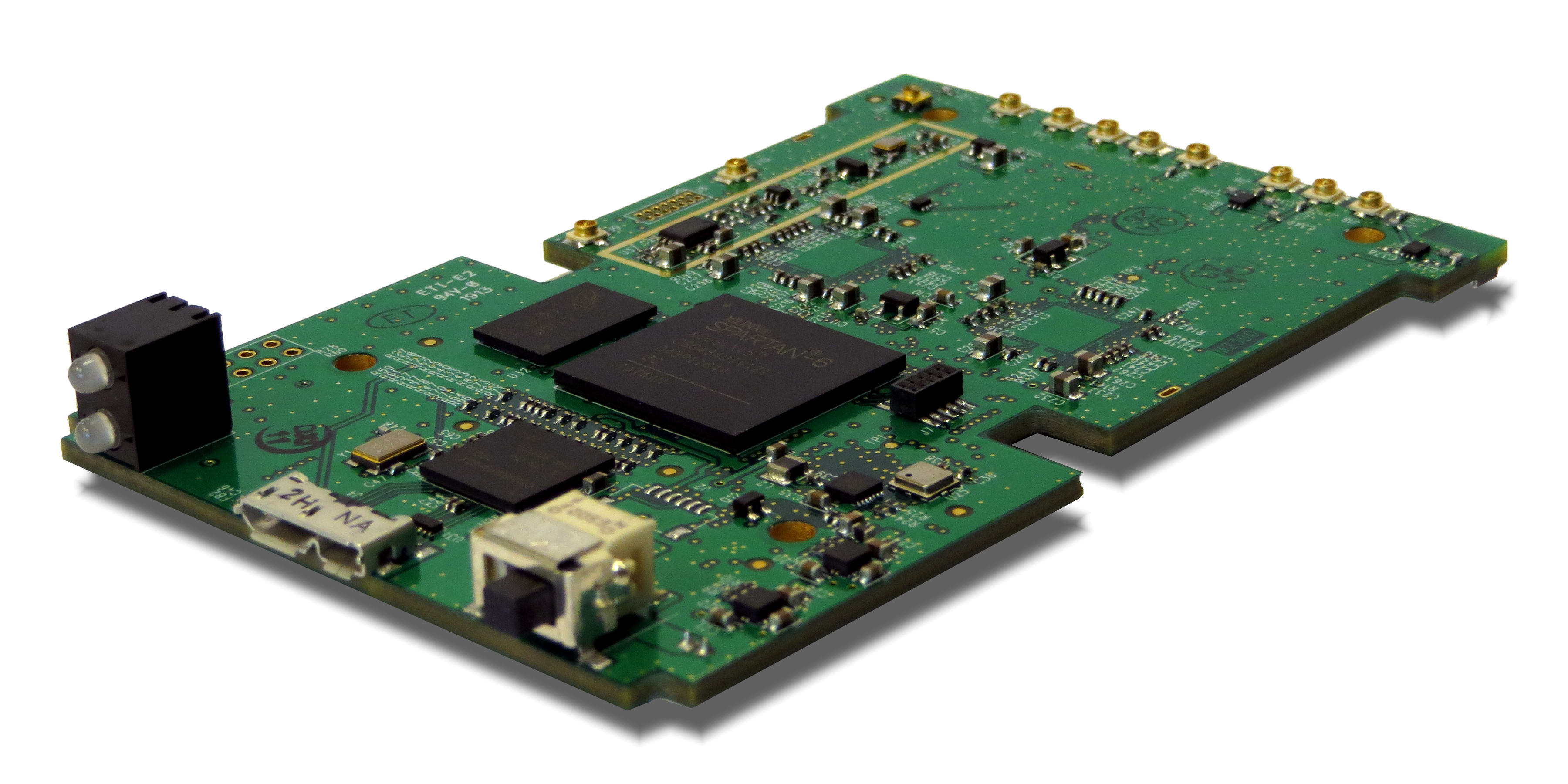
The ASR-2300 is a multiple-input and multiple-output (MIMO) transceiver module incorporating two wideband Field Programmable RF (FPRF) transceivers (300 MHz to 3.8 GHz) from Lime Microsystems, 10-axis accelerometer/gyro/compass/barometer sensors, and a large programmable FPGA capable of over 300 MiB/sec sustained communications with a host processor via USB 3.0 interface. The module’s nine integrated RF path options and low size, weight, and power characteristics contribute to ease of integration and portability. Accommodating both internal 1 PPM TCXO or external frequency reference, multiple ASR-2300s can be inter-connected via an expansion port and/or UART interface, supporting real-time reception / transmission of 4, 6, 8 or more signals without the need for significant additional hardware.
With on-board flash for storing developer customizable firmware and FPGA logic, the ASR-2300 can be configured to operate in a variety of different power profiles, maximizing battery life without requiring a host processor. The modules will be factory-programmed with only the RF receiver capabilities enabled. Developers can enable transmit functionality by modifying the firmware and waveforms.
The A2300 Open Source Project at Myriad RF
To encourage innovation in PNT and communications applications, Loctronix has partnered with Lime Microsystems to provide the source materials for the ASR-2300 module under open source licensing at the Myriad RF project.
“The broad utility of the ASR-2300 makes it an ideal platform for prototyping and developing advanced applications in the communications and PNT markets. Developers can make their own boards using the documents and design database contained in the A2300 project and/or purchase hardware, development kits, support services, and licensed waveforms directly from Loctronix,” Mathews said.
“Encouraging collaboration between the open source community and industry is a natural way to promote innovation and accelerate growth of SDR technology. We are delighted to partner with Loctronix to make their innovative ASR-2300 SDR design available to open source developers for creating advanced SDR applications,” said Lime Microsystems CEO Ebrahim Bushehri, Ph.D.
The open-source software package includes basic drivers for Linux and Windows environments enabling both GNU Radio and embedded C/C++ developers to interface with the ASR-2300 module. Developers can obtain source code and design documents for modifying the ASR-2300 to suit their own applications.
The ASR-2300 will be available from Loctronix this November. Adaptors, antennas, and a housing kit will also be available that provide a variety of configuration options supporting bench-top testing to wearable, battery-operated field demonstrations.
In recent years, there has been a substantial demand for indoor positioning and navigation equipment in the marketplace across verticals. Research and Markets has released a new report that indicates that there are multiple factors shaping the future of the indoor location market.
One such factor is the increasing number of applications that are addressing the expressed market need. Another is that the need to deploy cost control measures is being fulfilled by the indoor location apps. Even though the adoption of this technology is relatively slow, due to indoor environment challenges and performance requirements, these solutions are expected to grow steadily and shall have a pervasive existence across all the major verticals. Improved customer experience, on a real-time basis, will be the major pull factor, according to the report.
The indoor location research report analyzes global adoption trends, drivers and evolving platforms in this rapidly emerging market. The report aims at identifying and evaluating the current market size and the future market opportunities. Some of the major vendors of indoor location are Apple Inc., Google, Microsoft, Broadcom and Cisco. Many small innovative companies have also surfaced and are forthcoming as the solution providers for the indoor location market.
The research report, “Indoor Location Market: Global Advancements, Market Forecasts and Analysis (2013 – 2018),” categorizes the global market for indoor location into the following sub-markets:
Hardware devices: This segment shows the hardware technological trend and its inevitable effect on indoor location market.
Handheld devices: This segment gives unit shipments for smartphones, 3D enabled smartphone, tablets and 3D enabled tablets in this segment.
Network devices: This segment covers Wi-Fi integrated chips and Bluetooth integrated chips with their expected unit shipments over the period.
Proximity devices: In this segment, we cover expected global unit shipments for sensors.
Software: This segment refers to indoor maps and navigation software packages which can be downloaded into the hand-held devices for indoor location purposes. It also covers indoor location-based analytical tools to monitor patterns of pedestrian/ customers at various venues. Revenue generated from proximity engine is also included in this segment.
Apple’s acquisition of WiFiSLAM has brought smartphone indoor location technologies to the fore. With more than 1 billion new smartphones forecast to use indoor location technologies in 2018, there are still significant opportunities for companies with the right technologies and strategies, according to a report by ABI Research.
In ABI Research’s latest Location Technology report, “Smartphone Indoor Location Technologies,” it has forecast the adoption of different indoor location technologies, and the companies that are best placed to be successful. “We see a significant trend towards hybridization, with Wi-Fi, BLE and sensor fusion vital,” said senior analyst, Patrick Connolly. “By 2014, hybrid solutions will have already surpassed standalone indoor location technologies on smartphones, with Wi-Fi and sensor fusion hybrid solutions reaching over 900 million units in 2018. Longer term, technologies around optical light, object recognition and LTE-direct are all forecast to offer differentiation.”
“We are already seeing start-ups pivot out of this space, but there is still huge opportunity for partnerships and acquisitions with major Android handset vendors, carriers and large application developers,” said practice director Dominique Bonte. “Clearly Google is developing its own Wi-Fi indoor location solution; however, it may well open up its indoor location framework, enabling the market to expand much more rapidly. For IC vendors, with access to the hardware abstraction layer, indoor location innovation is vital for future socket wins.”
These findings are part of ABI Research’s Location Technologies Research Service, which includes research analyses, market data, insights, and competitive assessments focused on the indoor location market.
Satelles, a division of iKare Corporation, has entered into a patent and technology license agreement with The Boeing Company. This license allows Satelles to provide timing and location solutions to commercial markets delivered over the Iridium constellation of 66 low-Earth-orbiting satellites.
The timing and location signals are available anywhere on Earth, without the need for local infrastructure, making the system perfect for augmenting GPS and other location-based technologies, Satelles said. Unlike standard GPS, the high-power signals can reach into many building structures. The signal-in-space provides a location-specific signature that can reliably prove (or authenticate) the location of a mobile device or other equipment, while being virtually impervious to spoofing and other attacks, Satelles said.
Gregory Gutt, CEO of iKare Corporation, stated, “After working closely with Boeing for years to create a global indoor-positioning solution, we are thrilled to be entering this license agreement, which includes over 30 issued and pending patents.”
Michael O’Connor, CEO of the Satelles business, agreed. “We see tremendous dual use potential for the technology going forward. Indoor location is an exciting area, and we are seeing keen commercial interest in a solution that delivers trusted location for secure network communication or network transaction security.”
Satelles is headquartered in Silicon Valley, in Redwood City, California, with an office in Ashburn, Virginia.
The Insurance Institute for Highway Safety (IIHS) has contracted Locata to provide local, ground-based precision positioning signals for vehicle testing in a new $30-million expansion at the famous Vehicle Research Center, focused on vehicle automation testing. A novel indoor section of the expansion will allow replication of parking garages and urban canyons — where GPS will be largely masked — and will enable evaluation of technologies such as forward collision-avoidance systems in adverse conditions.
Used to be that changes to equipment in and on cars took decades to enter production. As an example, just how long did it take to get headrests/restraints into most vehicles? Restraint patents were originally filed in 1921, and people started to get interested in putting them in cars in the 1950s, but they didn’t start to show up in vehicles until the 1960s and weren’t mandated until 1969 in the U.S. Since then, the rate of technology adoption by the automakers has accelerated.
Now, it seems that almost every new car has Internet, Bluetooth phone, GPS navigation, rain-sensing wipers, touchscreen, automatic foot sensing/hand waving/touch sensitive lift-gate/door-locks/touchscreens, and even massaging seats and automatic seat positioning… And safety devices galore, including multiple air-bags and anti-lock braking systems, rear-view cameras, intelligent speed adaptation, and now even lane-departure and forward collision mitigation/collision avoidance systems.
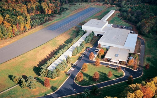
Safety has finally become a major selling feature on almost every make and every model, thanks in large part to organizations like the Insurance Institute for Highway Safety (IIHS) and the Vehicle Research Center (VRC) near Washington, D.C. The VRC is the principle location for U.S. vehicle crash testing that we see regularly on TV and YouTube videos with crash-test dummies being bashed around in all sorts of simulated vehicle accidents. These tests have led to significantly enhanced safety features in today’s vehicles.
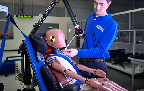
Instrumented crash dummy preparation. Photo: IIHS
Automation in vehicles, particularly automation of safety devices, is seen as the next most promising phase of vehicle safety improvement. And as these safety devices become more complex, they need to be verified in realistic conditions. Hence, the VRC is now undertaking a major expansion of its testing capabilities with the addition of a continuous vehicle test track that transverses not only open-air roadway areas, but also includes a 300-foot by 700-foot fully covered testing area.
Covered test track section expansion. Photo: IIHSExterior test track links new VRC facilities. Photo: IIHS
The $30 million upgrade will include a Locata supplied LocataNet, which will provide the VRC with high-precision positioning to enable rigorous, consistent and repeatable scientific evaluation of new vehicle crash avoidance systems. Along with the cm-level positioning provided by the Locata network, VRC is also working on state-of-the-art robotics to enable the required level of testing precision. The LocataNet will furnish the IIHS with a locally controlled positioning system that is seamless over all the VRC test areas, including extremely accurate and consistent automated positioning of vehicles.
In the covered enclosure, VRC intends to set up collision avoidance testing for areas such as parking garages and urban canyons — areas where GPS is either not available, or is degraded to a level where positioning is intermittent or isn’t available. Locata will provide a consistent level of accuracy and reliability that the VRC requires for these GPS-degraded scenarios.
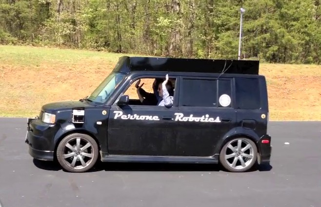
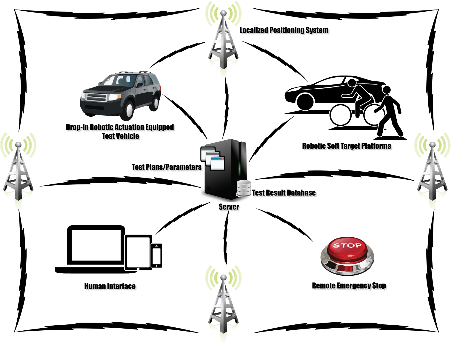
The VRC site currently looks very much like a construction site with the track extensions under way and the under-cover area just starting to be built. The VRC facility will come online in two stages — the outdoor track before the end of the year and the indoor around early Q2 next year. Locata engineers have been working with Perrone Robotics on very early integration testing. Perrone is contracted to deliver a system for testing vehicle safety systems in the test vehicles that IIHS is testing. For the first phase, the system includes a robot target vehicle with the footprint of a car, but only 4 inches high and 1 inch of ground clearance. If the vehicle being tested fails to prevent a collision with the robot target vehicle, the test vehicle runs over the robot target vehicle, dislodging a soft target, but avoiding damage to the test vehicle, robot target vehicle, or soft target.
(For a feature article on the Perrone Robotics soft-target unmanned ground vehicle and drop-in actuator kit, see the upcoming August issue of GPS World magazine.)
To ensure that the test vehicle drives repeatedly, the system also includes a drop-in actuator kit that can be installed into any test vehicle in 30 minutes or less. The system is designed to allow a human driver to sit comfortably in the vehicle and drive, but is also capable of controlling the throttle, brake and steering to drive test profiles. Perrone is using Locata as the positioning system. In addition to alleviating concerns about GPS outages or dead/weak signal spots, it also allows the system to be operated on the new, covered IIHS test track currently under construction.
DARPA Urban Challenge Peronne Robotics car. Photo: IIHSVRC robotic system using Locata positioning. Photo: IIHS
The Locata network has been running from ground-based tripods scattered around the track wherever construction will allow. IIHS will construct 30-foot masts on which to place Locata antennas, but even that is still several months away.
Locata’s autonomous positioning technology uses terrestrial networks that function as a “local ground-based replica” of GPS-style positioning. Locata works with GPS, but can also operate independently when GPS is not robust or is completely unavailable. Instead of orbiting satellites, Locata utilizes a network of small, ground-based transmitters that blanket a chosen area with strong radio-positioning signals. Because it is terrestrially based and provides relatively high power signals, Locata works in any internal or external environment.
A fundamental requirement for radio-positioning systems is nano-second-level synchronization of all transmitters in the positioning network. In the past, multiple atomic clocks were used to achieve this level of synchronization. Instead, Locata’s technology relies on a patented synchronization method called TimeLoc, which allows Locata to replicate GPS in a ground network.
Locata’s technology encompasses both the transmit and receive sides of the positioning network, allowing the system to be configured to meet specific, localized demand for availability, accuracy and reliability. This flexibility ensures that signal integrity can be guaranteed in even the most demanding environments — especially indoors, like the covered test track section of the expanded VRC.
Locata has also made significant progress in North America with the recent award of a contract to instrument the White Sands Missile Range to Locata’s partner TMC Design.The 746th Test Squadron’s new non-GPS-based positioning system is expected to be operational by Q3 2013, with a network that covers 2,500 square miles (6,500 square kilometers).Locata technology will provide the USAF’s “gold standard GPS truth system,” supplying continuous centimeter-level, independent positioning when GPS is completely jammed. This award followed several months of U.S. Air Force testing and evaluation of an initial LocataNet installation at the White Sands facility.
So, following the recent IIHS endorsement of the Locata technology for use at the VRC, Locata appears to be well on the way to acceptance as a reliable truth system for use alongside GPS. Along with other mining-related installations elsewhere in the world, it would seem that we are no longer in evaluation mode; rather, we should anticipate other future Locata production installations.
On June 6, the FCC, following a unanimous vote of the commission, issued an order enabling NextNav, LLC to begin commercial operation of its advanced positioning network, which is designed to support 911 emergency first responders. NextNav is deploying its nationwide network using Part 90 Multilateration Location and Monitoring Service licenses that are held by its affiliate, Progeny LMS, LLC. NextNav has been operating a fully-deployed location network for trial, testing and other non-commercial purposes in the San Francisco Bay Area for more than three years.
“We are pleased that the Commission has unanimously approved our ability to enter into commercial service,” said Gary Parsons, CEO of NextNav. “The commission conducted an extremely thoughtful review of the technical characteristics of our innovative system, and this order will allow us to offer location services that have the potential to significantly enhance 911 and public safety applications.”
NextNav’s high-performance terrestrial positioning network is designed to complement GPS in urban areas and inside structures, places where GPS is significantly degraded or denied due to blockage of the fainter, satellite-based GPS signal. The FCC-chartered Communications Security, Reliability and Interoperability Council Working Group III found that NextNav’s system delivered 90 percent smaller search rings then existing technologies in challenging indoor urban environments, and was the only technology tested capable of providing floor-level height accuracy.
The operation of this system is significantly enhanced by its use of Part 90 M-LMS spectrum licenses, which are designated for the location of mobile devices. The spectrum licenses used by NextNav cover nearly all major U.S. urban centers and over 93 percent of the U.S. population.
Indoor location research and fielded developments currently focus on consumer-level applications, mostly using mobile phone handsets, but this work will hopefully also benefit professional and high-precision uses of GNSS. Indoor location technologies could be of particular interest in machine control for warehousing, industrial assembly, indoor and even underground mapping, underground mining, in forestry where dense canopy virtually cuts out GNSS, construction, and other areas where sky-view is limited or negligible.
Tune in to Indoor Nav Webinar Thursday
Tune in to GPS World’s webinar, “Indoor Positioning and Navigation: Results of the FCC’s CSRIC Bay Area Trials,” on Thursday, April 18. Speakers include Khaled Dessouky (Technocom); Ganesh Pattabiraman (NextNav); Norm Shaw (Polaris Wireless); and Greg Turetzky (CSR). Registration is free.
Professional users will want to keep abreast of developments in the E-911 area, and be aware as achievable accuracies begin to approach what could be possible for precision applications. Right now, that’s maybe a pretty big stretch, but taking a look periodically is a good idea. A recent round of landmark tests by the Federal Communications Commission (FCC) provides just such an occasion for a look-in.
The U.S., E-911 legislation put in place back in 2001 required that both landlines and cellphones should provide the location of callers to within specific accuracy levels. Location information was to be sent transparently to Public Safety Answering Points (PSAPs) which would allow fire/rescue/police personnel to be dispatched to the location of the 911 call. For mobile phones, cellphone manufacturers and network providers forged ahead and implemented a number of location strategies using differing technologies — all require being outdoors where a clear sky-view is available.
GPS and augmented GPS technologies were only part of the cellphone solution. Other implementations included use of the cell-signal itself, along with an extensive database that can contain, amongst other things, signal attributes and network asset locations. Turns out that, today, around 60 percent of mobile phone calls are made within buildings, so the FCC started to investigate how to bring E-911 capability to indoor calls.
In 2011, the FCC commissioned a group called the Communications Security, Reliability and Interoperability Council (CSRIC), and Working Group 3 (WG-3) is the one currently investigating what can be done for indoor E-911 location. Drawn from interested industry participants, the WG-3 Location-Based Services (LBS) sub-group set about finding what technologies exist, how well they work, and how they could be applied to E-911. Now, there are a lot of people trying to crack this problem and many, many ways that it’s been tackled — all of which are at different stages of development and with differing levels of capability. In order to make definitive progress, WG-3 LBS decided that a test-bed was the best way to evaluate and compare what’s currently available.
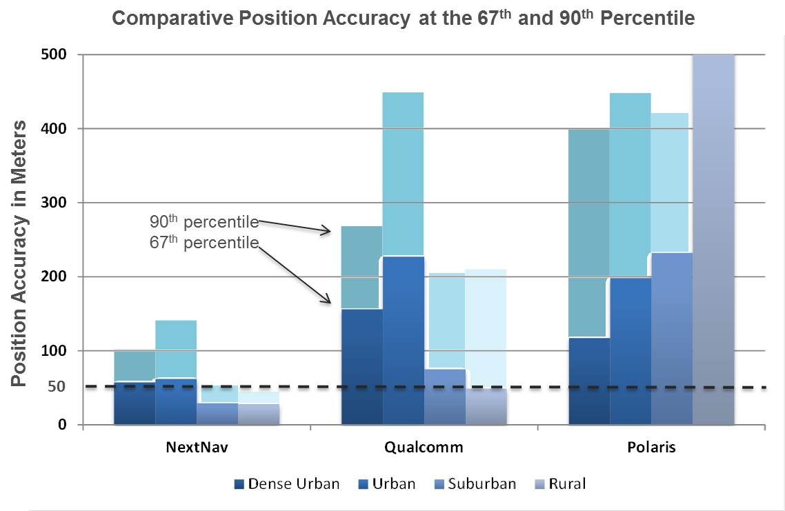
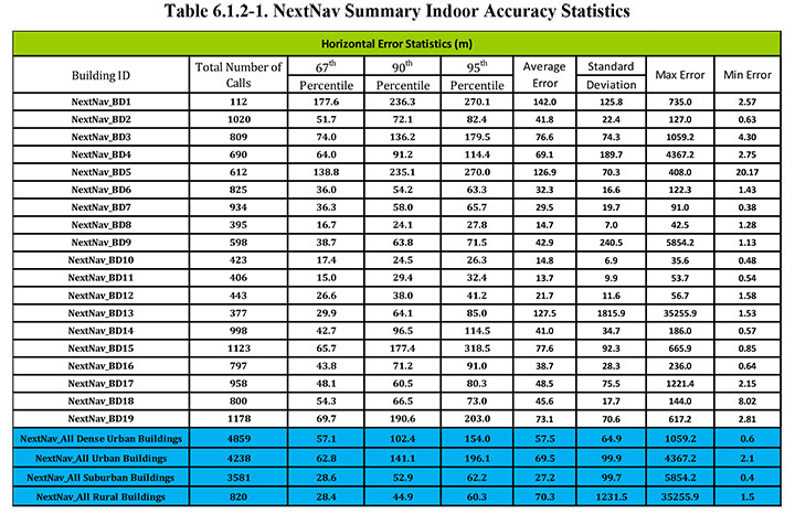
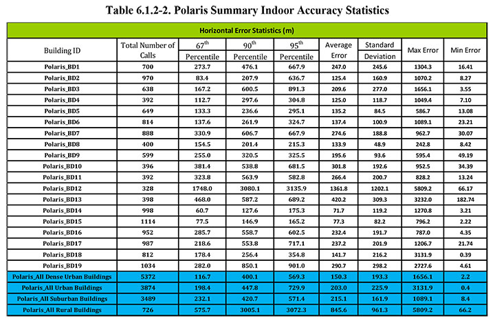
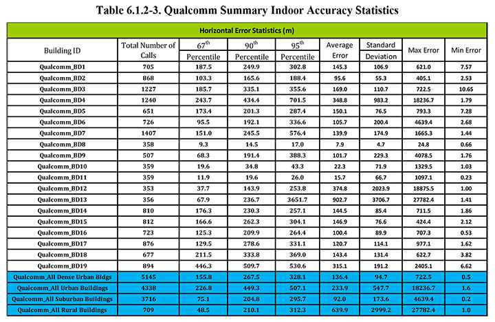
Seven vendors signed up initially, but only three — NextNav, Polaris Wireless, and Qualcomm — completed the rigorous testing, which set out to basically establish horizontal and vertical accuracy, speed of location, and reliability and consistency of results for each system. The trial tested the performance of location systems across urban, suburban and rural areas in the San Francisco Bay Area. More than 13,000 test calls were placed from various tested technologies in 75 different indoor locations selected by participating public safety organizations from around the U.S. Click here for the full report.
In the tests, Polaris Wireless used an RF pattern matching/fingerprinting technique, Qualcomm used a hybrid Assisted-GPS (A-GPS)/Advanced Forward Link Trilateration (AFLT) system, and NextNav used wireless beacon technology. NextNav came out on top, and largely within the magical 50-meter “search ring” requirement, and was the only vendor to provide vertical location capability.
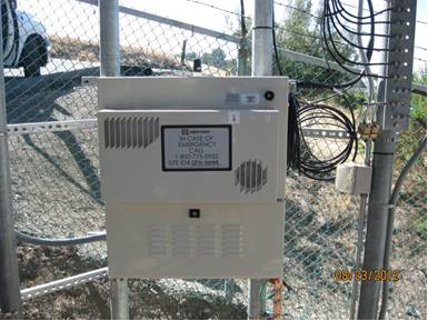
NextNav uses pressure transducers in its beacons and in the handheld units to accurately measure calibrated altitude — within about 2 meters — so it can actually report the floor where the handheld is located; it’s the only system tested that was able to do so. Apparently the use of MEMS pressure sensors in cellphones is forecast to increase to 681 million units in 2016, so this could be the right approach.
NextNav is focusing on the San Francisco market, where the company has fielded a significant number of beacons, but it has also placed beacons in another 40 metropolitan locations across the U.S. NextNav has acquired appropriate spectrum rights to transmit a 900-MHz “GPS-like” signal that’s synchronized to GPS. This enables good penetration into most urban buildings — both high-rise and those with fewer floors.
To support adoption of its solution, NextNav is working with a chipset manufacturer to incorporate processing of its location signal within an upcoming spin of an embedded cellphone chipset. While other solutions have adopted Wi-Fi and cell-signal solutions, NextNav contends that its approach is the most cost effective, as beacon deployment is geographically less dense and can be amortized over so many users.
NextNav Beacon.
Other solutions also apparently rely on the use of databases that store signal characteristics and a number of other parameters – the CSRIC report highlights the complexity this brings to database management and maintenance. NextNav also has a database, but this is basically to store records of location, cable configurations and calibration data. This is only used to ensure consistent performance of their system; it’s not required for network operation or location.
Higher precision applications would also benefit from this type of augmentation in the same way that WAAS users achieve higher accuracies, except this system uses local beacons, and there could be the potential for even higher precision with known fixed beacon locations within urban environments. As commercial UAV applications grow, it’s not impossible that there will be higher precision flight applications within cities, for geo-location surveying, building and outside appliance inspections, signal mapping, traffic mapping, road-work repair monitoring — in fact, many of the monitoring activities we see daily in towns and cities where a view of the sky can be particularly restricted.
The CSRIC participants are not the only ones pursuing the holy grail of indoor location. As mentioned, seven different location vendors/technologies began the process to demonstrate their performance indoors through the common test bed, but only three completed the process. The others remain highly motivated and involved, however, and at work tuning their varied solutions. The WG3 report states, “The following location vendors showed initial interest in having their technologies tested and highlighted through the test bed process, but ended up not participating in the Stage 1 test bed, for a variety of reasons.
LEO Iridium Satellite-based Positioning (BoeingBTL).”
Meanwhile, promising indoor location research goes on at a number of commercial and academic institutions, such as the University of Calgary PLAN group, which has focused on integration of Wi-Fi and GPS. An upcoming paper reports that Wi-Fi, using the 802.11 standards, can be employed in several different ways as a complementary positioning technology for GPS/GNSS navigation, and the two can be used in an integrated framework to provide a continuous and robust positioning service.
Another promising component for indoor location could be the recent release of a software application by Baseband Technologies, which can provide rapid ephemeris for up to 28 days, between ephemeris downloads from GPS directly or over cellphones from the Internet. But indoor location warrants much more extensive treatment than these few random comments — what’s summarized here are only some recent developments in E-911.
There will likely be another round of E-911 test-bed activities if funding and management issues are resolved. See CSRIC WG-3 LBS Subgroup member Greg Turetzky’s “Expert Advice” column from GPS World for perspective and a forward look. We can anticipate even wider participation by differing technologies and even greater levels of performance in future. Longer term progression towards higher precision professional applications seems to be inevitable.
The FCC released in March results of intensive indoor location trials of various technology solutions to this most difficult of PNT problems — yet the one that will unlock the greatest remaining untapped potential. The results will shape FCC-mandated position-reporting requirements for cell phones, and will drive future development of all indoor positioning applications. This story gives a top-level view of the results. For in-depth exploration, tune in to the free webinar this Thursday to hear critical information, insight, and perspective on this groundbreaking study from four key participants.
The April 18 webinar is free, but you must register beforehand. A downloadable file of the webinar will be available roughly one week afterwards, in case you miss the live presentation. Speakers include Khaled Dessouky from TechnoCom Corporation, a company that supervised the trials; Ganesh Pattabiraman from NextNav and Norm Shaw from Polaris Wireless, two companies whose technologies underwent rigorous testing in the trials; and Greg Turetzky from CSR, a company closely involved in the process.
Testing Overview
Conducted by the Communications Security, Reliability, and Interoperability Council (CSRIC) of the Federal Communications Commission (FCC), Working Group 3 (WG3), the tests trialled thousands of attempted location fixes in four representative morphologies (dense urban, urban, suburban, rural) and various building types.
The massive R&D movement focus on consumer-level applications, that is, cell phones, but this work will also ultimately affect professional and high-precision uses of GNSS. Those involved in machine control for warehousing, industrial assembly, indoor and even underground mapping, construction both above- and underground, underground mining, utility work, and even forestry will find this of particular interest — any activity in areas where sky-view is limited or negligible.
Today, well more than half of mobile phone calls are made inside buildings. The number of emergency calls roughly parallels that, and both figures are only projected to rise. The FCC has a clear mandate to bring E-911 capability to indoor calls.
The 2001 regulations governing such emergency calls required that both landlines and cellphones should provide the location of callers to within specific accuracy levels. Location information was to be sent transparently to public safety answering points (PSAPs), to dispatch fire/rescue/police personnel to the source the 911 call, and not just to the right street address, but to the right floor of a multi-storied building. That’s the driver for all this.
Widespread application of successful technology/ies meeting the indoor requirement, once determined, is the key to significant revenue for many parties, not least of them GNSS manufacturers and location-based services (LBS) providers.
GPS and augmented GPS technologies were only part of the cellphone solution, and other implementations included use of the cell signal itself along with an extensive database which can contain amongst other things signal attributes and network asset locations.
The WG-3 Locations Based Services (LBS) sub-group set about finding what technologies exist, how well they work and how they could be applied to E-911. Click here for the full report.
In the tests, Polaris Wireless used an RF pattern-matching/fingerprinting technique, Qualcomm used a hybrid assisted-GPS (A-GPS)/advanced forward link trilateration (AFLT) system, and NextNav used wireless beacon technology.
WG3 selected the San Francisco Bay Area for the Stage-1 Indoor Test Bed. The methodology centered on indoor testing in sample buildings within the most common wireless use environments, called morphologies: dense urban, urban, suburban, and rural.
Dense urban: Bldg. 2: One Front Street, San Francisco, California.Urban: Bldg. 18: Super 8 Motel on O’Farrell St., San Francisco, California.Rural: Bldg. 13: Gilroy Gaits, Beige Stable Building, Hollister, California.
Polygons surrounding areas containing 19 buildings were selected; the distribution of buildings tested was 6 dense urban, 5 urban, 6 suburban and 2 rural. 75 test points were selected by TechnoCom within these 19 buildings. Statistically significant samples of stationary test calls were placed from each test point using multiple test devices for each of the 3 location technologies under test by NextNav, Polaris Wireless, and Qualcomm.
More than 13,000 valid test calls were collected across the test points for each of the three technologies. Broad, representative wireless industry participation in the test bed meant that Polaris’ results were aggregated over AT&T’s and T-Mobile’s networks; Qualcomm’s results were aggregated over Sprint’s and Verizon’s networks; and NextNav operated essentially as a standalone overlay location network.
A certified land surveyor provided indoor ground-truth accuracy to compare test-call locations. The certified accuracy was +/-1 cm horizontal and +/-2 cm vertical.
The test results show the location-performance attributes under test: horizontal location accuracy, vertical accuracy, yield, time to first fix (TTFF), and reported uncertainty.
Satellite signals (in this instance, GPS) have, of course, significant challenges in penetrating large buildings. Consequently, AGPS fall-back modes, such as AFLT, were experienced frequently. Accuracy degraded as expected when GPS fixes were not attained. While a surprising proportion of hybrid fixes were experienced, even at test points where one would not expect a satellite signal to penetrate, the quality of the hybrid fixes was in general significantly degraded compared to GPS fixes.
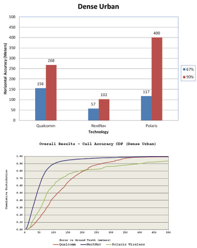
RF finger-printing experienced its best performance in the dense urban setting. This is probably a combination of a confined environment that could be extensively calibrated and many RF cell sites and handoff boundaries that could be leveraged in creating a good RF fingerprint map of the dense urban center.
The best observed performance in the dense urban setting was that of the dedicated terrestrial (beacon) location system — a new infrastructure. However, due to multipath, location fixes that may be relatively close in absolute distance (for example, 40 meters away) are often located in a building across the street, in a neighboring building, or even across a few blocks from the test point.
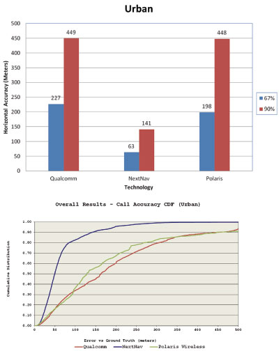
Urban Environment
Each individual test building in the urban morphology produced different challenges, and the three technologies under test met them in varying degrees.
A major-league baseball stadium created a situation where AGPS fallback fixes could be very far away due to the exposed RF propagation outside the structure in which the test points were located. Stadium structure created challenges to RF fingerprinting at some test points.
A convention center created in some cases an environment that was deep indoors but with very strong cellular signal from cell sites inside the building. This made the beacon-based location system perform poorer than in most other test points, since attenuation to different directions in the outside world was particularly strong in those scenarios. AGPS and RF fingerprinting relied on the cell sites inside the structure to create adequate location fixes.
An older building of comparatively heavy construction, with a large atrium in its middle, produced widely varying results based on distance from windows or the atrium. Again, the phenomenon of apparent location in a building across the street was seen for both NextNav and Qualcomm. RF fingerprinting fixes appeared to cluster about the larger reflectors in this urban corner of San Francisco, which happened to be mostly across the streets from the target building.
A motel building demonstrated the unique challenge with indoor location: absolute distances (like 50 or 150 meters) which may have meant much in assessing outdoor performance mean less for the indoors, since emergency dispatch to the wrong building or even the wrong block could be easily encountered at those distances. A location across the street is certainly better than one a few or many blocks away but it may still leave some human expectations unmet.
A tall condominium building in a (non-dense) urban downtown San Jose created relatively poor AGPS performance, uneven beacon system performance, and RF fingerprinting performance that degraded with the height of the test point. All of the above factors related to each of the urban buildings, combined with a generally lower cell site density for fall back (than in dense urban), resulted ultimately in an aggregate urban performance that is slightly worse than the dense urban performance.
Suburban Environment
The effect of smaller buildings with lighter construction and more spacing between buildings quickly became evident. Outstanding GPS performance, almost as good as outdoors, can be achieved inside single-story homes. Similarly outstanding performance is achieved on average by the beacon-based location technology under similar circumstances. RF fingerprinting appears to suffer from performance degradation compared to more dense morphologies in the city.
The AGPS performance predictably changes as the suburban buildings become bigger and higher. The terrestrial beacon-based network continues to perform well in the larger suburban. RF finger-printing shows some enhancement relative to the smaller suburban buildings, but still shows most of the location fixes along the roads, highways or reflecting buildings.
Rural Environment
Large one-story structures with metal roofs limited the available number of satellite signals available for trilateration. In these cases more hybrid fixes were experienced with a concomitant increase in the spread of the location fixes about the true location. The performance of the beacon-based network was less impacted by the metallic roof (since that roof had more impact on sky visibility rather than on side visibility towards terrestrial beacons). Consequently the performance was somewhat better than for AGPS. The performance of the beacon-based network would of course depend on the density of its deployed beacons covering the rural area, which was sufficient in the case of the rural test polygon.
RF finger-printing showed reduced performance relative to the suburban environment due to the large spacing between surveyed roads (where calibration is done) and the rural structures as well as the lower density of cell sites.
Conclusion
Finally, the report concludes: “Stage-1 of the test bed contained in the end only three technologies to test. With the complexity of the task at hand, this created a good learning opportunity for both CSRIC WG3 members and the test house. However, there are a number of technologies that are either in use for location based services (LBS) or that are emerging which should be evaluated for their potential to contribute to the improvement of indoor wireless E911.
“Indoor wireless E911 is a critical public safety issue that will only increase.”
One key factor that the report does not at all address is relative cost of implementing these respective solutions. The same can be said for timeline. While some observers have concluded that “NextNav came out on top,” this solution in particular can be presumed to face much greater challenges for full or nationwide implementation than the other two, which rely largely on already existing infrastructures.
Another round of E-911 test-bed activities will ensue once funding and management issues are resolved. See CSRIC WG 3 LBS Subgroup member Greg Turetzky’s “Expert Advice” column from GPS World for perspective and a forward look.
Once again, for an up-close and personal look at the CSRIC Bay Area indoor tests, register beforehand here for Thursday’s webinar, April 18. A downloadable file of the webinar will be available roughly two weeks afterwards, in case you miss the live presentation.
The long awaited results from the independent field trial of indoor wireless location technologies are here. TheFCC-chartered Communications Security, Reliability and Interoperability Council (CSRIC) tested NextNav, Qualcomm and Polaris. NextNav bested the others.
Speakers from NextNav and Polaris, as well as test adminstrator Technocom, will take part in a GPS World webinar on April 18. Registration is free.
Also, there is a guessing game in town and stakes are high. Who will President Obama nominate to replace FCC Chief Julius Genachowski? Tom Wheeler, popular in the telecom community, has been a front runner, but the tide may be turning against him with some charging that he is too snug with our industry.
Developers will be even more enticed to utilize indoor location now that Apple has signaled its market intents with the purchase of indoor-GPS company WifiSLAM. Safety and security mandates around the world are spurring a wave of telematics offerings by automotive OEMs. For more, read on.
Who Will Be the New FCC Chief? A coalition of public interest groups sent a letter to Obama warning that Wheeler is too close to the industry that he would be regulating. “You can’t have an objective chairman of the FCC that’s got 20 years of his life invested in being the head lobbyist for industry,” Sascha Meinrath of the New America Foundation said in an interview. In his past life, Wheeler was an industry lobbyist and also served as head of both CTIA and the National Cable and Telecommunications Association.
Adding to Wheeler’s woes, 37 Democratic senators have signed a letter supporting FCC Commissioner Jessica Rosenworcel. Since she already sits on the commission, Rosenworcel would not need Senate confirmation to ascend to the chairmanship. That could be appealing to Obama, who has faced GOP opposition to many of his second-term nominees.
However, it could also put Obama in a sticky spot, as he would have to jump over the FCC senior Democrat, Commissioner Mignon Clyburn, the daughter of Rep. James Clyburn, a member of the House Democratic leadership who has strong African-American support. Obama has been criticized for low minority leadership appointments in his second term.
Genachowski’s term was a disappointment to people on many sides of the fence, but not the all-out disaster of his predecessor, Kevin Martin. Genachowski will be remember for the introduction of the National Broadband Plan, as well as plans for a complete overhaul of the Universal Service Fund. During his time as chairman, Genachowski took the lead on killing AT&T’s proposed $39 billion acquisition of T-Mobile. The next FCC chair will need to navigate hefty issues including media ownership, Internet rules, universal and affordable broadband, and locking of phones.
How Good Is It Indoors? The FCC chartered CSRIC to test the indoor performance of location systems across urban, suburban and rural areas in the San Francisco Bay Area. TechnoCom, an independent agent, conducted the trial with more than 13,000 test calls placed from different technologies in 75 unique indoor locations. Three vendors submitted technologies for evaluation: Qualcomm, NextNav and Polaris. They were scored for horizontal and vertical accuracy, speed of location, and reliability and consistency of results. NextNav stood out for its performance on height and horizontal accuracy. The full report is available from the FCC.
To hear from the experts involved, tune in to GPS World’s webinar, “Indoor Positioning & Navigation: Results of the FCC’s CSRIC Bay Area Trials,” on Thursday, April 18. Speakers include Khaled Dessouky (Technocom); Ganesh Pattabiraman (NextNav); Norm Shaw (Polaris Wireless); and Greg Turetzky (CSR). Registration is free.
Apple Goes Inside. Apple has acquired indoor-GPS company WifiSLAM, a sign that the indoor mobile location market will be heating up. Apple’s involvement is a significant move that will ignite the developer community to rush to create more innovative apps and solutions based on indoor location. WiFiSlam is a two-year-old start-up that detects a phone user’s indoor location by analyzing the strengths and IDs of Wi-Fi signals in its vicinity. WiFiSlam has been offering the technology to developers for indoor mapping and new types of retail and social networking apps. Retail has been the first adopter of indoor technology.
Interactive Voice Ads Leverage Location. Nuance Communications unveiled Voice Ads, a new mobile ad format that enables consumers to interact directly with ad campaigns by speaking (or perhaps, yelling) into their smartphones. Voice Ads expands on voice and natural language technologies and leverages capabilities like location to deliver ads that prompt the user to ask questions. In a YouTube video, Mike McSherry of Nuance demonstrates a virtual Magic 8-Ball campaign that answers users’ verbal queries to promote a fictional deodorant brand. “Mobile has a monetization challenge,” McSherry told AllThingsD. “By introducing voice you can transcend the small screen size.”
Telematics Boom. The telematics market is about to ride a wave of growth. Vehicle OEMS are rolling out safety telematics in advance of safety and security mandates throughout the world including Europe (eCall, 2015), Russia (ERA GLONASS, 2013) and Brazil (Contran, 2013). ABI predicts that the OEM and aftermarket safety/security telematics vendors will see the number of users rise from 72 million at year-end to more than 300 million in 2018.
GPS Ankle Monitors Not Working. In 2012 the state of California started conducting tests on the GPS ankle devices that monitor more than 4,000 high-risk sex offenders and gang members. Officials discovered that the batteries died early and reported locations were off by as much as three miles. Tampering alerts failed and offenders could cover the devices with foil or use GPS jammers to go undetected. Many of California’s ankle monitors were replaced with devices from a different vendor, but test results of the new system were not made public.
CrowdOptic, a maker of crowd-powered mobile applications for live events, and the Location Based Marketing Association (LBMA) have joined forces to develop and promote new focus-aware mobile technology for fans at live events.
Part of LBMA’s mandate is to foster research, innovation and pilot projects that push the boundaries of place-based marketing. Through this initiative, LBMA has partnered with several top-tier global brands carefully selected from among LBMA’s large network of marketing affiliates to introduce the new technology to consumers. The technology will be introduced in a series of test launches at major entertainment events throughout the summer, before making it widely to marketers in the fall, the association said.
Focus awareness combines traditional GPS-location awareness with data on where mobile users are aiming their smartphones. Focus-based technology enables new kinds of apps in which users aim their phones to engage with one another as they watch events simultaneously — for example to connect, chat or vote on the shared subject of focus. Focus-awareness also allows marketers to chart the shifting momentum in crowds.
The partnership comes as demand grows among LBMA’s network for mechanisms to enhance context-awareness in mobile. Marketers want to know how many phones are engaged with their apps as events are happening (heat), who those users are, where they are looking, and how the crowd’s engagement is dynamically changing moment to moment — all capabilities of CrowdOptic’s technology.
“Our vision of the future is new apps that dynamically adapt based on knowing what activities people in a crowd are watching and engaging in, as well as joining people with shared interests together, right there in the moment,” said Asif Khan, founder and president of LBMA.
“Focus is an emerging mobile category that will play a significant role in the next generation of location services,” said Brent Iadarola, Global Research Director of Mobile & Wireless Communications at Frost & Sullivan. “In contrast to augmented reality, which combines location and mobile Internet search to provide information on landmarks in static environments, focus-based services enable the tracking and tagging of objects (or individuals) in moving or dynamic environments. By enabling mobile users to point their phones at moving objects or people to access real-time information about their subject of interest, this area of technology in which CrowdOptic is a pioneer clearly presents some very unique and lucrative avenues for hyper-targeted marketing promotions, advertising, and mobile coupons.”
CrowdOptic is in use around the world in apps that enable users to “aim their phone” to act or interact — whether to discuss, report or discover other people based on their shared focus. The company powers a range of applications which vary from finding friends in a crowd, to aiming a phone to vote, to aiming to alternate views of a live broadcast, to aiming to connect with athletes and celebrities at live events. The technology works both through an app and anytime without an app, by historically mining the standard metadata tags embedded in shared photo images. The mechanisms used to acquire context beyond location include continuous streams of GPS, compass and triangulation algorithms illuminating common points of focus between mobile users.
The LBMA will begin to introduce these projects which leverage the CrowdOptic platform for top global brands beginning in the summer of 2013.
About LBMA – http://thelbma.com/
The Location Based Marketing Association is an international group dedicated to fostering research, education and collaborative innovation at the intersection of people, places, and media. Our goal is simple: To educate, share best practices, establish guidelines for growth and to promote the services of member companies to brands and other content-related providers. The over 600 members of the LBMA include retailers, restaurant chains, agencies, advertisers, media buyers, software and services providers, and wireless companies.
Communications Security, Reliability, and Interoperability Council (CSRIC) Update
By Greg Turetsky
Many of us remember way back in 2001 when the FCC first announced E911 position reporting requirements for cell phones. That was a long time ago in many significant ways. Everyone had 2G phones and anxiously anticipated the arrival of 3G, and with it, data. Most people still had a landline at home, and used their mobile sparingly lest they overrun their monthly minutes. Roaming was very expensive and nearly impossible overseas. Very few phones had GPS, and people only turned it on when needed, as it significantly reduced battery life.
Now, in 2013, all of the technology has changed, but — not unexpectedly — the regulations have not. This is one of the reasons the U.S. Federal Communications Commission (FCC) created CSRIC.
The Communications Security, Reliability, and Interoperability Council’s mission is to provide recommendations to the FCC to ensure, among other things, optimal security and reliability of communications systems, including telecommunications, media, and public safety. The current council, CSRIC III, was born on March 19, 2011, and ended on March 18, 2013. Working Group 3 (WG-3), the E911 Location Accuracy group, has looked into both outdoor and indoor location accuracy issues to help the FCC shape new guidelines. I don’t think any of us would argue that given the current patterns of cell phone usage, the ability to provide a location indoors to a public safety answering point (PSAP) is something that is now needed, has significant value to the public, and would seem to lie within our grasp technically.
Working Group 3 is a fairly large group of experts from a wide variety of backgrounds. The actual list of participants is publicly available; what’s more interesting is the groups that they represent. Three main constituencies constitute the Working Group: the public safety community, the wireless operators, and the technology vendors. Each group has a slightly different goal, but they all worked well together to produce clear, unbiased reports that represent all the different members’ views in a way that lends more credibility to the overall report.
On March 14, the FCC released two reports created by WG-3: the “Indoor Location Test Bed Report,” and “Leveraging LBS and Emerging Location Technologies for Indoor Wireless E911 Report.” I will not review either document here as they are available publicly, but I will summarize the highlights of the reports from my perspective as a member of the location community and a concerned citizen, and attempt to predict where the process might lead next.
Figure 1. Indoor accuracy in the dense urban environment.
Test Bed Report. In my mind, two key results emerged from the Test Bed Report. The first was very positive: the test bed showed that there are technologies capable of yielding positions indoors, and their performance can be compared analytically. This may seem like a bland statement, but it carries a significant amount of weight with both the public safety community and the FCC. It acknowledges that the technology has evolved sufficiently such that in a test bed setting, we can gather and compare, in an apples-to-apples way, the performance of diverse technologies in terms of yield and accuracy. Similar to the LightSquared reports, this report focuses on ensuring that the data itself is valid. The interpretation of the data is far too politically and economically charged to be agreed on by all parties involved. It is a great accomplishment to concur on a methodology by which testing should be done, and to produce a set of results that can be given to the FCC with the entire council’s approval.
The second highlight from my perspective was less positive. The test bed originally had seven participants, but in the end only three completed the process. This indicates that there are even more candidate technologies for solving the indoor E911 problem — but for a variety of reasons, they were not ready for CSRIC testing at this juncture. Although having three choices is good, seven (or even more) would be better for the FCC to feel confident in its ability to create a new mandate with sufficient flexibility on implementation. There are clearly many ways to skin this cat technically, but we have to ensure that the test bed methodology allows as many as possible viable alternatives to be compared. There is clearly a gap between those technologies that are commercially available and those that can be used for E911.
Leveraging LBS. The Leveraging LBS Technology report also reached some interesting conclusions. The concept of leveraging LBS was actually how I became involved in the CSRIC. The underlying question that the FCC asked me to explore was “Why can a smartphone user can get a dot on a map indoors (usually with an uncertainty circle, no less), but no location information shows up on the PSAP screen if he makes an E911 call?”
As we dug into this problem, it became clear that this was less of a technology problem and more of a business/policy one. Quite a few large companies make money by providing that indoor location for various applications, but there isn’t any real money in E911 — although there are lots of liabilities. Also, many of these solutions are proprietary either to the phone, the operating system, or the application, while an E911 solution would need to be standardized across all of those as well as different carriers.
Figure 2. Indoor accuracy in the urban environment.
Conclusion. The FCC has received two reports with similar conclusions: We have come a long way since 2001, but we might not be there — the indoor E911 promised land —just yet.
There is still more to come, however. Therefore, many participants and observers hope the work of the current CSRIC will lay the foundation for a rational conversation about indoor E911 right now, and still be around to allow for future improvements. We have recommended that the test bed be maintained so future results can be compared with current ones. At issue is the funding source for the test bed. The FCC has announced the coming of a CSRIC IV, but has not released any further details. It is certainly the hope of WG-3 that the work performed to date to establish and validate the test bed will be available for use by future technologies as they mature.
Locating emergency callers indoors is a critical capability that we as society must address — not for the callers’ convenience, but for their safety and or public safety generally. The problem has technical, commercial, regulatory, financial, legal, and public safety facets to it, making it a very complex issue.
I should also note, that although E911 is a U.S. regulation, the problem of indoor location is under scrutiny in nations all over the world. I earnestly hope that all sides can continue working together to find a solution that can be implemented for the benefit of everyone.
Greg Turetzky is senior director, CTO Office, for CSR. He served on the CSRIC Working Group 3 LBS Subgroup. He will participate in a April 16 GPS World Webinar on this topic. Registration is free.