While grapes are being harvested throughout Italy, the Politecnico di Milano is looking to the future of viticulture with an innovative approach that combines mechanics, IT and digital simulation.
A team of researchers from the Departments of Mechanical Engineering and Electronics, Information and Bioengineering at the Politecnico di Milano has developed a system to test and optimize self-driving strategies for agricultural tractors in a virtual environment.
The study, published in AgriEngineering (“Scenario Generation and Autonomous Control for High-Precision Vineyard Operations}, presents a complete methodology for creating realistic vineyard scenarios and evaluating control algorithms for autonomous driving. The goal is not simply to reduce the human presence, but to provide a high-fidelity digital environment in which to develop, verify and safely improve agricultural automation solutions based on sensors and predictive algorithms.
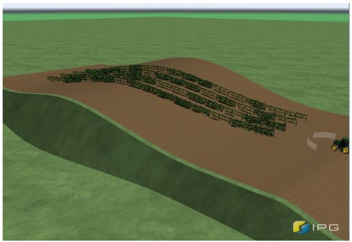
The research has made it possible to create a digital twin of the vineyard, capable of reproducing slopes, soil irregularities and row layout. Tractors equipped with low-cost GNSS and inertial measurement systems (IMS) sensors and guided by advanced algorithms have been tested in this virtual environment, vehicles capable of moving autonomously between rows and of performing off-field turning manoeuvres with the utmost precision.
The study explored new methodologies to simulate and independently control vineyard operations. (Credit: Politecnico di Milano, CC BY-SA).
“Our approach combines terrain modeling, advanced control and realistic sensors in a single simulation environment. This speeds up research and reduces the risks and costs of real field tests,” said Federico Cheli, professor at the Politecnico di Milano, Department of Mechanical Engineering, and project coordinator.
According to the researchers, the use of realistic simulations not only reduces the risks and costs of field tests, but can also become a useful tool for operator training. It can accelerate the adoption of new agricultural technologies.
The project stems from the partnership between researchers at the Politecnico di Milano and the company Soluzioni Ingegneria s.r.l. that develops software for dynamic vehicle simulation. It is part of a broader context of cooperation with industrial companies engaged in research on automation and sustainability in agriculture.
Ruiz Mayo, C.; Cheli, F.; Arrigoni, S.; Paparazzo, F.; Mentasti, S.; Pezzola, M.E. Scenario Generation and Autonomous Control for High-Precision Vineyard Operations. AgriEngineering 2025, 7(2), 46. https://doi.org/10.3390/agriengineering7020046
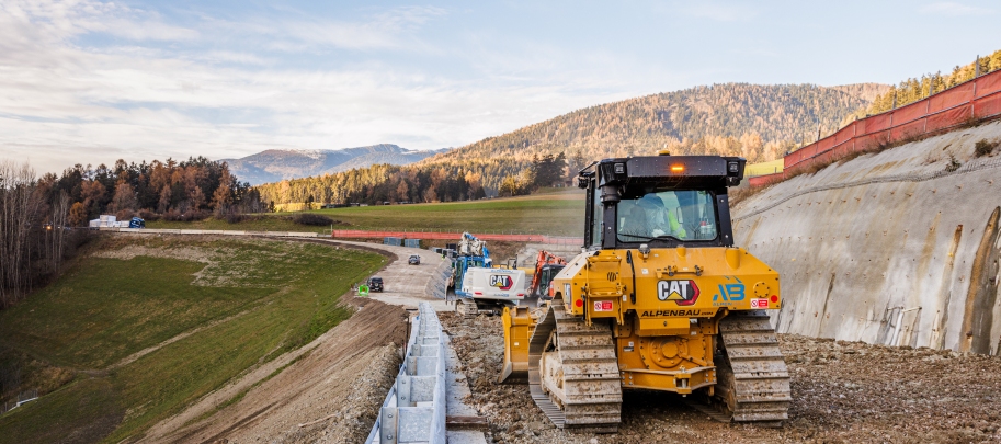
The construction of the Perca Bypass, a critical infrastructure project underway in the Italian Alps, highlights the increasing role of advanced technology in managing complex builds. Located near the village and commune of Perca — a destination known for its tourism trade — the new 632 m tunnel and supporting road network are designed to improve regional connectivity and enhance commuter safety.
The project, which began in 2023 and is expected to take three years to complete, is being delivered through a joint venture between European construction group Strabag and regional specialist Alpenbau. Once finished, the bypass is expected to relieve the flow of up to 26,000 vehicles that pass through Perca daily during peak periods, easing congestion and opening new routes for both tourism and local commerce.
Given the large number of machines, teams, and partners involved, coordinating the work requires effective management and communication tools. Alpenbau, drawing on a long-standing collaboration with Topcon Positioning Systems, the team is now using Topcon’s Aptix Integration Platform, which enables site managers to monitor and oversee progress remotely, offering real-time insights into workflow and project status without leaving their offices.
Acting with Aptix
“Aptix is a very convenient solution for us to manage our construction sites,” said Benjamin Niederkofler, CEO of Alpenbau. “One of the advantages of Aptix is that you can directly load 3D models onto machines that are equipped with machine control systems. This means that you always have the possibility to monitor the site from the office. This is a very important and fundamental tool for us to remotely monitor a construction site.”
Aptix consolidates data from different contractors and machinery, regardless of the manufacturer or operating system, and provides a comprehensive view of project performance. Senior leaders can access essential metrics in real time, such as work progress, fuel consumption, and carbon emissions, improving the ability to make informed decisions.
Control, Collaboration, Clarity
Throughout every stage — from planning and design to actual construction — the platform supports automatic workflows that deliver designs to machines and collect telematics data without manual intervention. This automation reduces the risk of missing information and helps maintain clear communication among stakeholders.
A joint effort of this scale requires constant collaboration among contractors, local authorities and other stakeholders. The Aptix platform helps facilitate transparency in workflows by allowing access to daily productivity reports and construction data, supporting open cooperation and oversight for both project managers and crew.
“Recently it has become increasingly important that we create transparency and co-operation on this construction site and share productivity daily with construction management or even with our customers,” said Niederkofler. “Having this transparency across the entire construction site is a decisive advantage.”
Andrea Marzi, technical director at Strabag Italy, added, “This unique platform allows all parties involved in the project to access all relevant construction information and data.”
Once completed, the Perca Bypass is expected to generate new economic opportunities for the region. Project leaders say that by adopting innovative digital workflows and centralized data management, they are able to direct complex operations more effectively and deliver the project with increased speed and accuracy.
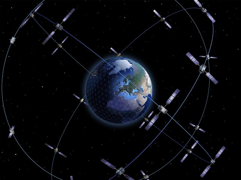
Telespazio, a joint venture between Leonardo and Thales, has been selected by the Italian Space Agency (ASI) to lead the creation of the “National GNSS Competence Centre” in Italy. As the primary contractor, Telespazio will head a team composed of Italian universities, research centers, and industrial companies to establish this new center, which will be headquartered at Telespazio’s offices in Rome.
The center’s primary goal is to develop a laboratory network that utilizes resources distributed throughout Italy to advance capabilities, solutions, and technologies in satellite navigation. The project team includes notable institutions such as the National Institute of Metrology Research (INRiM), the Italian Aerospace Research Centre (CIRA), Qascom and the National Inter-University Consortium for Telecommunications (CNIT), along with research units from the University of Pisa, the Polytechnic of Turin, the University of Padua and the University of Roma Tre.
The center will focus on creating new software tools for monitoring GNSS service performance and testing receivers. A cloud-based collaborative platform will be implemented to facilitate shared software development among all project participants. Additionally, the center seeks to expand its network by involving other academic and industrial partners while establishing itself as a national hub for satellite navigation expertise through workshops and training courses.
Telespazio will focus on developing precise, resilient, and robust navigation systems, particularly for emerging technologies such as autonomous vehicles in the aviation, rail, and automotive industries.
Telespazio operates one of two Galileo control centers at its Fucino Space Centre.
According to Rokubun — a Spanish company that designs accurate and scalable navigation solutions based on GNSS — released a library solution for decoding and processing Galileo Open Service Navigation Message Authentication (OSNMA) for embedded platforms.
The solution is part of the Horizon Europe BANSHEE project, for which Rokubun served as the coordinating, is EU-funded, and is supported by the European Union Agency for the Space Programme (EUSPA). The goal of the project was to develop a hybrid technology that combines Wi-Fi ranging and satellite navigation (including the Galileo OSNMA) to allow for accurate and seamless indoor-outdoor navigation.
The upcoming Galileo OSNMA will provide authenticated navigation data message against data-level spoofing attacks. By delivering data authentication, the free-to-use Galileo OSNMA assures users that the received Galileo navigation message comes from the system itself and has not been modified by, for example, a spoofing attack.
To address this risk, Rokubun’s library enables the Galileo OSNMA in embedded GNSS solutions. The cross-platform, small-footprint library has undergone extensive testing using official EUSPA test vectors, and all OSNMA algorithms have been validated in real conditions at the European Commission’s Galileo testing facilities located at the Joint Research Centre in Ispra, Italy.
The library is organized to be portable, requiring only a working assembler and C compiler that supports ISO C99. To ensure optimal performance and validate user-specific enhancements, such as the utilization of cryptographic accelerators or other system-on-chip/microcontroller specific resources, Rokubun has implemented a hardware-in-the-loop continuous integration/deployment setup.
This setup continuously tests the library against several reference MCU targets, assessing its performance and guaranteeing its reliability.
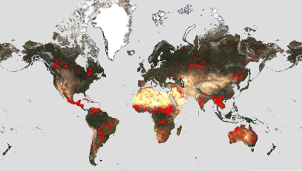
Wildfires have recently spread across Greece, Italy, Spain, Portugal, Algeria, Tunisia and Canada, causing mass environmental and economic damage as well as human casualties. Scientists have warned that wildfires are becoming more frequent and more widespread.
In response, an upgraded version of the World Fire Atlas from the European Space Agency (ESA) is now available. The atlas provides a detailed analysis and map of wildfires across the globe.
Rising global temperatures and the increased extreme weather has led to a surge in the number of wildfires rapidly consuming extensive areas of vegetation and forested lands.
Considering the severe wildfires, ESA has reopened its World Fire Atlas which offers an insight into the distribution of individual fires taking place at a global scale.
Through its interactive dashboard, users can compare the frequency of fires between countries as well as analyze the evolution of each wildfire taking place over time. The atlas was first available in 2019 and it supported both European civil protection agencies and firefighters.
The dashboard uses night-time data from the sea and land surface temperature radiometer (SLSTR) on board the Copernicus Sentinel-3A satellite. Working like a thermometer in the sky, the sensor measures thermal infrared radiation to take the temperature of Earth’s land surfaces which is used to detect the fires.
Data from the Copernicus Sentinel-3B satellite will be added to the atlas in December.
Over the previous seven years, data from the World Fire Atlas show a substantial number of fires detected in Portugal, Italy, Greece, France and Spain.
Data also shows that Canada has experienced 11,598 fires during the first seven months of this year alone. This is a 705% increase compared to fires detected over the same period of the previous six years. Canada is currently battling the country’s worst wildfire season on record, with more than 10 million ha of land burned, which is said to increase in the coming weeks.
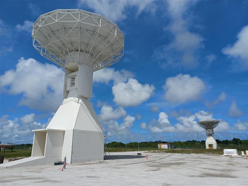
Galileo’s ground segment has gained a new asset, the Telemetry, Tracking and Control (TT&C) facility — a 13.5-m parabola dish mounted on top of a 10-m high building structure of made of steel and concrete. It is based within Europe’s launch site in Kourou, French Guiana, beside TTCF-2.
The TT&C antennas are uncrewed and operate on a fully automated basis from the two Galileo control centers located in Oberpfaffenhofen, Germany, and Fucino, Italy. The TT&C antennas are crucial to regular communication with the Galileo satellites.
This latest antenna will play an important role during the upcoming modernization activities of the earlier TT&C antennas in the station network, which have been in service for several years. TTCF-7 will take over their tasks during the maintenance activities when they need to be taken offline.
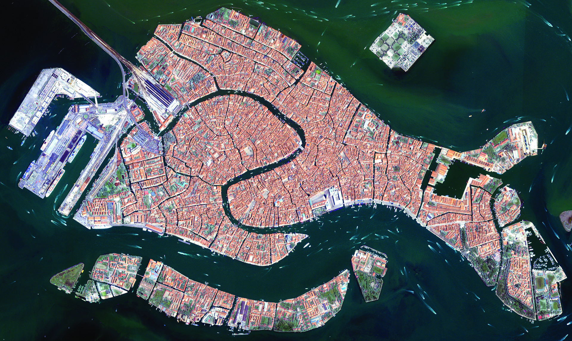
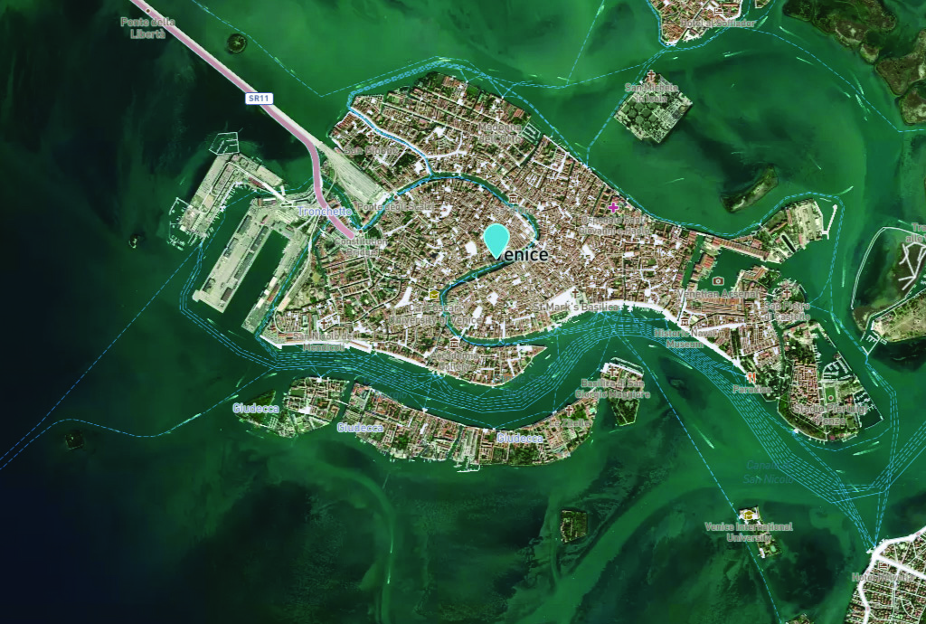
Venice arose after the fall of the Roman Empire. The city holds 450 palaces, more than 400 bridges and is home to the notable St. Mark’s Basilica. It is also known for its many canals, which are full of gondolas the way the streets of other cities are full of taxis or rickshaws. (Image: Freeartist/iStock/Getty Images Plus/Getty Images)
It is hard to believe that Italy’s “floating city” could be underwater soon.
The average rate of relative sea-level rise is 2.5 mm/year, per the European Geosciences Union’s journal Natural Hazards and Earth System Sciences. This photo of Venice from the European Space Agency (ESA) was taken in 2008 by Ikonos-2, a commercial satellite (Image: ESA)
Predictions for the future of the city vary, but most scientists agree that the sea level is rising due to climate change. Natural Hazards and Earth System Sciences, an interdisciplinary journal of the European Geosciences Union, published a report in 2021 suggesting the average sea level could be between 17 cm and 120 cm higher in Venice by 2100.
Venice was built in the middle of a shallow lagoon in the Adriatic Sea. Therefore, it has always been at risk of flooding or “acqua alta,” meaning high water. There is evidence of severe flooding dating back to around the 8th century.
The Venetian lagoon is more than 500 km2 in total, but has an average depth of only 1 m, according to Royal Museums-Greenwich. High tides and severe storms have a devastating impact on the wetland environment on which Venice is built.
Compared to the image of Venice in 2008, this U.S. Geological Survey (USGS) satellite image of Venice from May 2023 shows the rise in sea level within the past 15 years. (Image: USGS)
In November 2019, Venice experienced the second-worst flooding event in almost 100 years. The tide reached 187 cm (6.1 ft) above sea level, covering 80% of the city in water, reported the BBC.
City records show there have been 324 intense high-water events since 1872 and more than half of those have been in the past 30 years. Among the many and vast consequences of human-caused climate change may be the end of one of the world’s most beautiful cities.
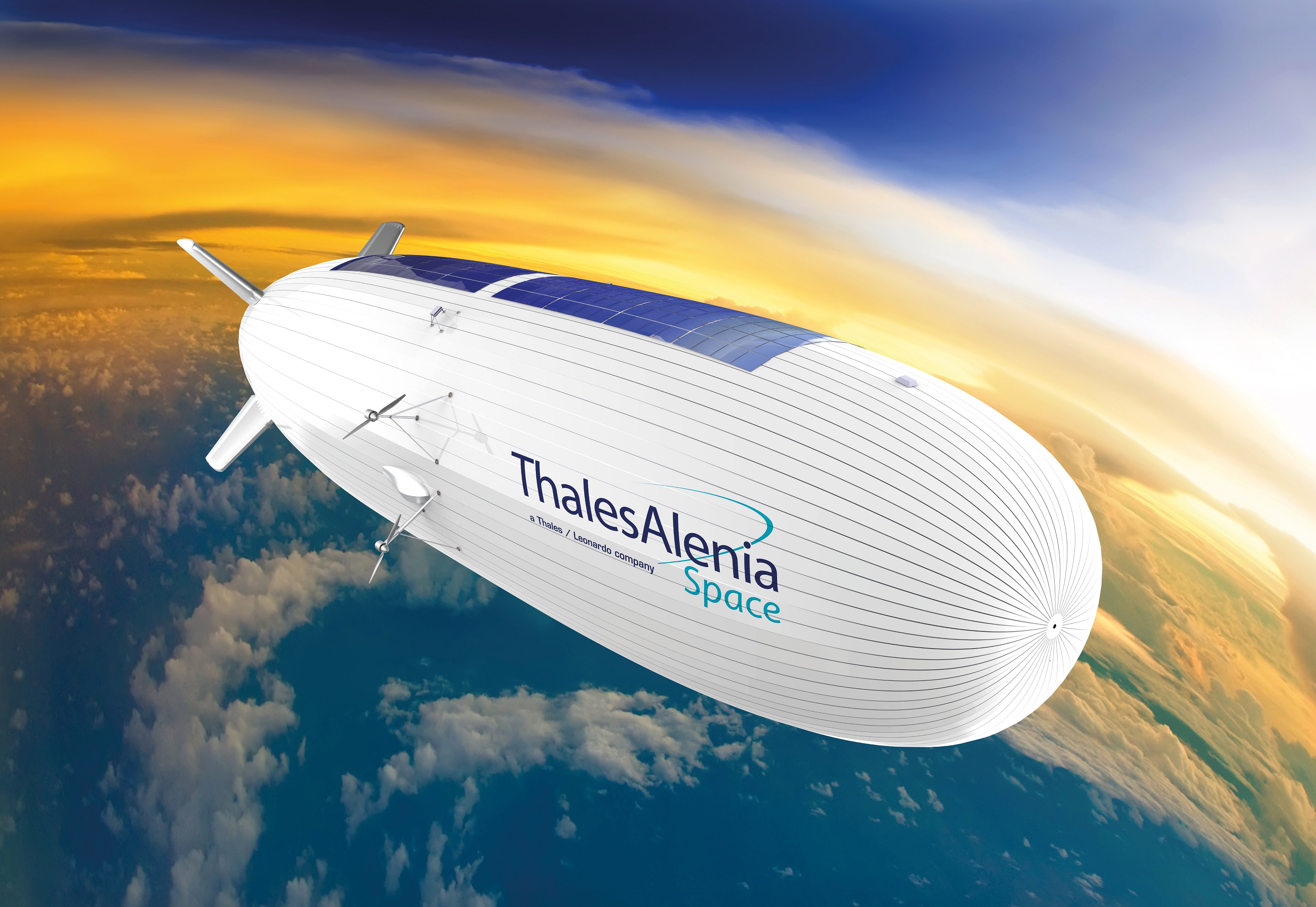
Thales Alenia Space has signed a €43 million contract for the Euro High-Altitude Platform Systems (HAPS) demonstration project. EuroHAPS was selected by the European Commission on July 20, 2022, for collaborative defense research and development projects from the European Defense Fund.
EuroHAPS aims to develop several stratospheric demonstrators for missions designed to improve intelligence, surveillance and reconnaissance and communications capabilities. Project partners include companies from Italy, Spain, Germany and France.
The project will conduct flight demonstrations for three types of complementary stratospheric platforms: A reduced-scale Stratobus from Thales Alenia Space, a solar-powered airship designed for long-endurance missions and offering large payload capacity, Hybrid High Altitude Airship from the Italian Aerospace Research Centre capable of generating extra lift with a wing airfoil, and autonomous stratospheric balloon system from ESG and TAO consisting of a series of three altitude-controllable balloons.
These three types of platforms are complementary and feature different operating times, capacity and operational restrictions. They will give Europe a broad spectrum of solutions to meet a variety of different requirements.
The platforms will test a range of missions, including lidar observation to detect and classify targets at sea or on land and the ability to detect them in environments with vegetation cover. Communications intelligence and electronic intelligence missions will also be tested, as well as a meshed broadband communications network for air and land players.
HAPS offer a new opportunity to complement ground-based, satellite-based or airborne assets with unique capabilities tailored to operational requirements. These flight demonstrations of HAPS will enable demonstrations of different platforms and address the main technical risks associated with these new technologies while refining operational requirements to ultimately enable development of future HAPS systems.
A crucial step toward the development of the Galileo Public Regulated Service (PRS) military user segment took place Monday, Feb. 8, with the kick-off meeting in Brussels of the GEODE (GalilEO for EU DEfence) project, according to a press release from FDC.
GEODE is the biggest Galileo application development project ever launched.
Sponsored by Belgium, Germany, Italy, France and Spain — contributions should exceed 82.7 million euros — GEODE is supported by the EU with a grant of about 44 million euros. The ambitious defence-cooperation project is under the umbrella of the European Defence Industrial Development Programme (EDIDP) of the European Commission.
GEODE will establish the framework for developing the Galileo PRS user segment for defense applications. At kick-off, the project involved 30 companies and organizations from 14 EU Member States: Belgium, Czech Republic, Estonia, Finland, France, Germany, Greece, Italy, the Netherlands, Poland, Portugal, Spain, Sweden and Romania.
The GEODE Roadmap
National defense organizations — in close cooperation with industry — have defined a roadmap for the Galileo PRS military user segment development, beginning with a specification and standardization phase. GEODE will prototype, test and qualify
seven PRS security modules developed from various technologies
nine PRS receivers (including two server-based variants)
four GPS/Galileo PRS-compatible anti-jamming controlled radiation pattern antennas (CRPA).
A common and standardized test environment will be developed as well as a PRS infrastructure to ensure the availability of the security assets for operational testing.
Finally, military operational field testing will be organized on military platforms (naval, land and drones) and timing and synchronization systems in (at least) Belgium, Czech Republic, France, Germany, Greece and Romania.
A PRS solution for spacecraft will also be designed and prototyped.
Beyond paving the way for the equipment of EU Member States defense forces with Galileo PRS, the military user segment that is developed, tested and certified under GEODE is planned to be available for export to other countries that have the necessary PRS security agreements with the EU.
The GEODE project will be completed in 2026.
Plans are for GEODE to
boost EU competitiveness in the highly strategic domain of military positioning, timing and synchronization.
foster the equipment of EU Member States’ military forces with Galileo PRS capability, essential to reinforce their interoperability and autonomy.
facilitate access to complex security-certified technologies and make them affordable through means of standardization and by creating the necessary critical mass.
In brief, the project will bolster EU Member States’ military capability, create business opportunities for the EU industry in the field of military application of satellite navigation, and maximize the benefits of the Galileo programme by energizing the adoption of its PRS service in all EU Member States and beyond.
Background on GEODE
This project has received funding from the European Defence Industrial Development Programme (EDIDP) under grant agreement No 039.
The GEODE industrial consortium is led by FDC and comprises the major industry players of the field: Airbus Defence and Space, Antwerp Space, Cy4gate, Diehl Defence, Elettronica, Fraunhofer Institute for Integrated Circuits IIS, GMV Aerospace and Defense, Indra Sistemas, Safran Electronics and Defense, Leonardo, Siemens Aktiengesellshaft, Orolia, Tecnobit, Telespazio, Thales Alenia Space Italia, Thales AVS France, Thales SIX GTS France, accompanied with 12 other EU companies acting as subcontractors (c.f. picture hereafter).
The GEODE project is developed in the context of the European Radio-navigation Solution (EURAS) project of the Permanent Structure Cooperation (PESCO). The EURAS project aims at promoting the development of EU military positioning, navigation and timing) capabilities and future cooperation taking advantage of Galileo and the PRS.
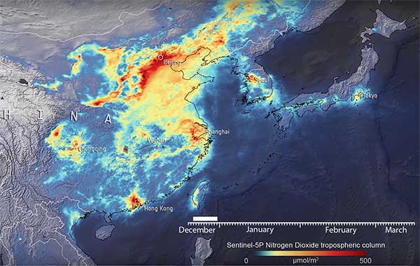
Descartes Labs, a geospatial data analytics company, is using satellite imagery analysis to examine how the coronavirus reduced nitrogen dioxide (NO2) emissions in China.
NO2 is produced by vehicles, power plants and heavy industries such as cement manufacturing, which were shut down during the coronavirus epidemic.
Descartes Labs shared its visualization in a Facebook post. The visualization maps a time series of NO2 levels across Eastern China, Japan and the Korean Peninsula using data from the European Space Agency (ESA) Sentinel-5P satellite.
Plots of NO2 emissions from 2019 compared to 2020 show declines of nearly 60%. Read more on Descartes Lab’s blog.
Copernicus data shared
In a video provided by ESA, a drop in concentrations in late January is visible in China, coinciding with the nationwide quarantine; from the beginning of March, the nitrogen dioxide levels have begun to increase.
Italy reduction
Copernicus data also reveals the decline of air pollution, specifically nitrogen dioxide emissions, over Italy. This reduction is particularly visible in northern Italy, coinciding with its nationwide lockdown to prevent the spread of the coronavirus.
“Satellites offer a unique vantage point to monitor the health of our planet,” said Josef Aschbacher, ESA’s director of Earth Observation Programmes. “Sentinel-5P is one of seven Copernicus satellites in orbit today. It currently provides the most accurate measurements of nitrogen dioxide and other trace gases from space.
“As nitrogen dioxide is primarily produced by traffic and factories, it is a first-level indicator of industrial activity worldwide,” Aschbacher said. “What is clearly visible is a significant reduction of nitrogen dioxide levels over China, caused by reduced activity due to COVID-19 restrictions, but also the Chinese New Year in January. The Copernicus programme is a perfect example of how space serves all European citizens by combining the political strength of the EU with the technical excellence of ESA.”
“We can certainly attribute a part of the nitrogen dioxide concentration reduction to the impact of the coronavirus,” said Claus Zehner, ESA’s Copernicus Sentinel-5P mission manager. “We currently see around a 40% reduction over Chinese cities, however these are just rough estimates, as weather also has an impact on emissions. We are conducting a detailed scientific analysis which will soon provide more insights and quantified results in the following weeks and months.”
The Copernicus Sentinel-5 Precursor mission, also known as Sentinel-5P, is dedicated to monitoring air pollution by measuring a multitude of trace gases as well as aerosols — all of which affect the air we breathe.
By Fabio Dovis, A. Minetto, A. Nardin, Politecnico di Torino Department of Electronics and Telecommunications, E. Falletti, D. Margaria, M. Nicola, M. Vannucchi, LINKS foundation
Following the issue by the Galileo Service Center of the Notice Advisory to Galileo Users (NAGU) reporting Service Outage for all the Galileo satellites, as curious Galileo users our team of researchers of the NavSAS group started an independent investigation of the received signals in space (SISs).
In fact, we observed that a commercial ublox EVK-M8T receiver, forced to use Galileo-only satellites, provided a “no-fix” indication. Three Galileo-enabled smartphones, the Xiaomi MI 8, Huawei P 10 and Samsung Galaxy S8, which use assistance from the cellular network, were also not providing a Galileo-based position solution, considering the Galileo satellites as “not usable.”
However, the investigation started exploiting our in-house developed software receiver NGene, that was used in the past for similar monitoring of the GNSS signals, for example at the time of the transmission of the first IOV Galileo satellites in 2012, and the transmission of anomalous GPS signals from SVN49 in 2009. Monitoring the Galileo SISs, which were usable until the day before, we found that they were still correctly trackable, with normal power levels and Doppler profiles within feasible limits.
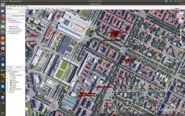
At the time of the first analysis, seven satellites were visible in the sky over Torino, Italy. Figure 1 reports a screenshot of the positions computed by means of NGene between 07:14:54 and 07:24:54 UTC on July 15, plotted on Google Earth. The position estimated using the Galileo-only satellite or hybrid GPS-Galileo solutions (red dots) showed errors on the order of 500 meters or even more. The georeferenced antenna position is depicted by the green pin.
Figure 1. Misplaced Galileo and GPS+Galileo solutions. (Screenshot: Politecnico di Torino and LINKS Foundation)
The monitoring of the status flags taken from the Galileo E1B I/NAV message showed that the SIS was marked as “healthy” for all the visible PRNs apart the number 14, which is known to be “not usable” for a long time. The Signal in Space Accuracy Index (SISA) was set to 109, which is an acceptable prediction of the minimum standard deviation of an overbound of the SIS error.
According to the Galileo Open Service, Service Definition Document (OS SDD, issued 1.1, May 2019), a SIS “Healthy” means that the SIS is expected to meet the Minimum Performance Level and “a navigation solution obtained with Galileo SIS is expected to meet the Minimum Performance Levels reported in the Galileo OS SDD only if receivers comply with the assumptions reported in Section 2.4, including the use of navigation parameters within their broadcast period.”
In fact, the document specifies that “The navigation solution is expected to meet the Minimum Performance Levels only if receivers do not use navigation parameters beyond their broadcast period. The maximum nominal broadcast period of a healthy navigation message data set is currently 4 hours.”
The check of the nominal broadcast period was bypassed in our software receiver, which is indented as a research tool and not a commercial product as the one mentioned above, so that we were still able to obtain a GPS + Galileo PVT solution, since this check looked to be the only discrimination factor to validate and thus exclude the computed solution.
On July 17, the SISA flag was changed to 255: according to the OS SDD, the accuracy status was “No Accuracy Prediction Available (NAPA).” This means that the status of the broadcast SIS must be intended as “Marginal.” In this condition the EVK-M8T restarted to provide Galileo-based fixes, while the Xiaomi Mi8 Pro smartphone still excluded the Galileo satellites from its PVT fix.
The analysis of the decoded Galileo navigation message led to the conclusion that ephemerides and clock correction data were last updated around 19:00 UTC of 1July 16. For example, PRN 3 and 15 changed Issue Of Data (IOD) from 958 to 17 at Galileo Signal Time TOW 241855, which corresponds to 19:01:25.
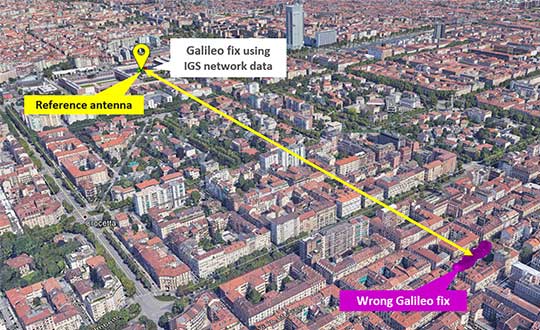
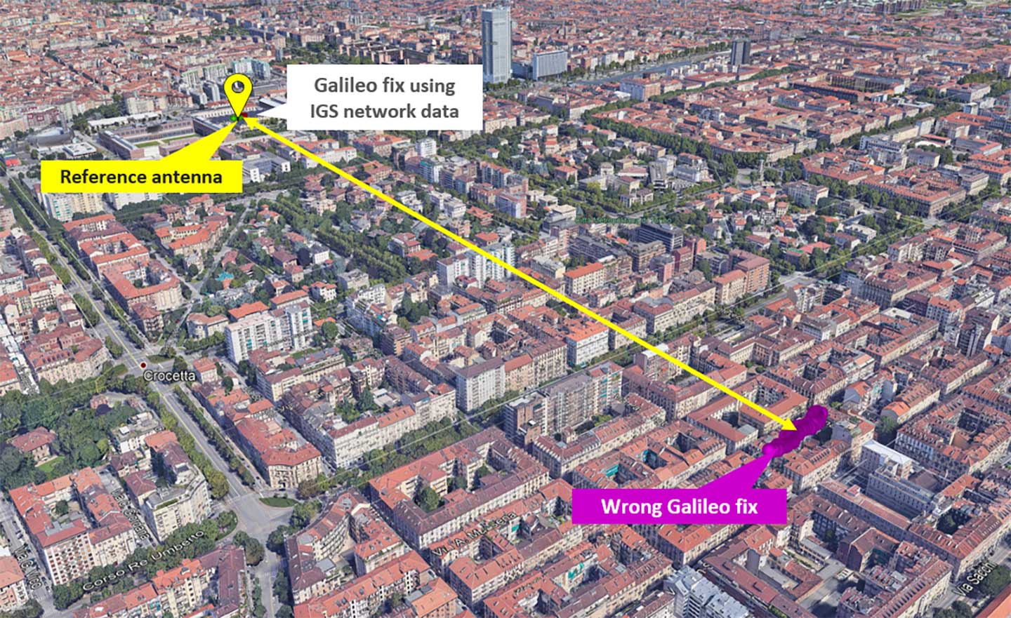
As a final check, we used external ephemerides to process the Galileo signals during the “system outage.” Figure 2 and Figure 3 show different navigation solutions obtained by processing a data collection taken on July 12 at 10.00 UTC (12.00 Local time). The purple dots indicate few fixes obtained by demodulating the navigation message transmitted by the Galileo satellites and show a remarkable bias with regard to the reference antenna location.
Figure 2. Comparison of Galileo-only solutions using Navigation message ephemeris data and IGS ephemeris. (Image: Politecnico di Torino and LINKS Foundation)
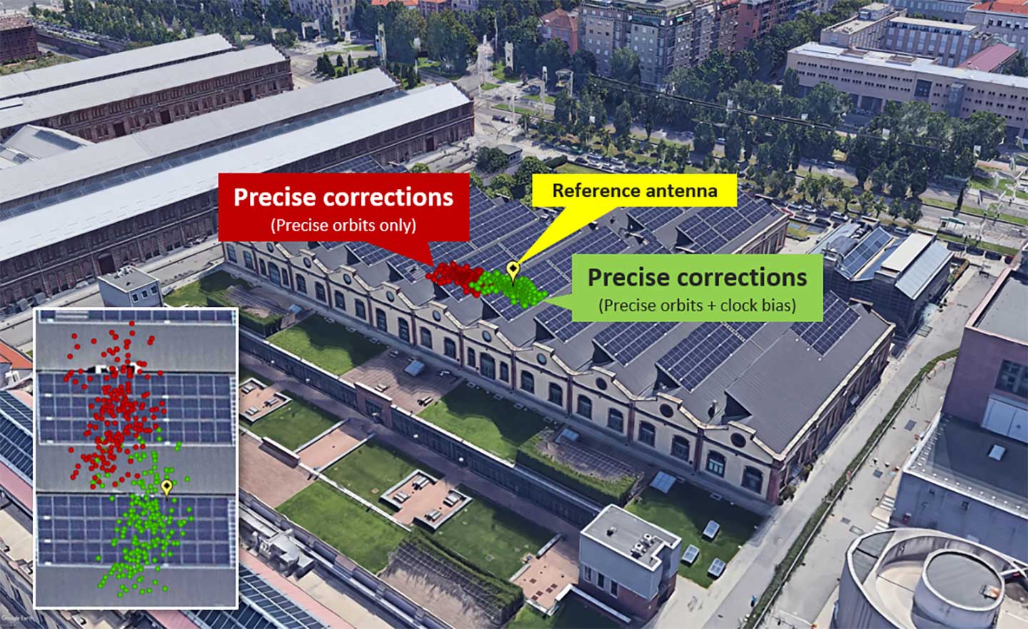
Figure 3. Zoom on the Galileo-only positions obtained by using IGS data.(Image: Politecnico di Torino and LINKS Foundation)
In Figure 3, the green dots are the navigation solution obtained correcting the satellites positions according to precise orbits data and clock drift provided by the IGS network. The fix is a simple code based Least Mean Square solution without smoothing of the pseudoranges.
The two results were obtained by processing the same satellites signals, thus proving that their quality was still sufficient to get an acceptable positioning solution during the Galileo service outage period. This brought us to the conclusion that, during the outage, only the ephemerides updates were affected by problems, while the other SIS components appeared sound and usable.
The European Union (EU) project BLUEGNSS has been developing GNSS applications in selected European airports to increase safety and airport accessibility, according to the European Commission’s Community Research and Development Information Service (CORDIS).
BLUEGNSS’s focus has been on advancing the adoption of the Galileo system in Greece, Italy, Cyprus and Malta. The four countries together form the Blue Med functional airspace block (FAB): airspace in which air traffic is managed irrespective of national boundaries. Blue Med is one of the nine FABs formed in Europe to reduce the fragmentation of the European air traffic network.
Three-dimensional GNSS approaches are being designed for 11 airports in the Blue Med FAB: four each in Greece and Italy, two in Cyprus and one in Malta.
The primary aim is to harmonize the implementation of required navigation performance approaches among the four countries, CORDIS said. This will enable aircraft to fly along precise flight paths with greater accuracy, and will make it possible to pinpoint aircraft position with precision and integrity.
Three new procedures. So far, substantial progress has been made towards safety and airport accessibility in the target countries. Since the beginning of 2018, three new GNSS procedures have been validated for Italian airports Cuneo, Lamezia and Parma, followed by another two for Larnaca and Paphos in Cyprus.
The poor weather conditions under which the Cyprus GNSS approaches were validated served to demonstrate the benefits of GNSS vertical guidance. Since its launch in 2016, BLUEGNSS has designed and validated 14 GNSS procedures.
Augmented performance of Galileo has been achieved through the European Geostationary Navigation Overlay Service (EGNOS). EGNOS is a satellite-based augmentation system that improves GNSS positioning. Its three satellites and network of more than 39 reference stations in 24 countries enable it to provide greater accuracy than Galileo alone.
EGNOS’s safety advantages and lower investment costs greatly benefit small and regional airports, which usually can’t afford the high costs of installing and maintaining ground-based navigation aids.
For this reason, BLUEGNSS has promoted its use in this geographically challenging Mediterranean region.
“The southeast Mediterranean region lacks full EGNOS coverage,” said GNSS expert Patrizio Vanni of ENAV S.p.A., project coordinator and Italy’s air navigation service provider. “To make things even more challenging, each airport involved in the project presents a very different operational environment.”
The project hasn’t only focused on designing and validating GNSS approaches at airports where no such procedures have been available up to now. It has also provided the necessary training and monitoring to support implementation by the Blue Med FAB countries.
Now close to completion, BLUEGNSS (Promoting EGNSS Operational Adoption in Blue Med FAB) is the first project of its kind to be coordinated at FAB level. It may serve as a catalyst to spread required navigation performance approach know-how in the region and beyond, to the whole of Europe.