Tag: Leica Geosystems

  • Leica Geosystems Adds Cloud-Based Imagery with HxIP

    HxIP_in_Leica_Infinity

    Leica Geosystems announced that it is taking the first step toward bringing live-streamed intelligent cloud-based imagery into all field applications, beginning with the launch of the Leica Nova MS60 MultiStation, Leica Nova TS60 Total Station, Leica Viva TS16 Total Station and Leica Zeno 20 handheld.

    Geospatial professionals in the U.S. and Canada who invest in these new solutions can become part of this pioneering effort and add even more intelligence to their dataset with up to one year of introductory free access to georeferenced imagery from the Hexagon Imagery Program (HxIP), the company said.

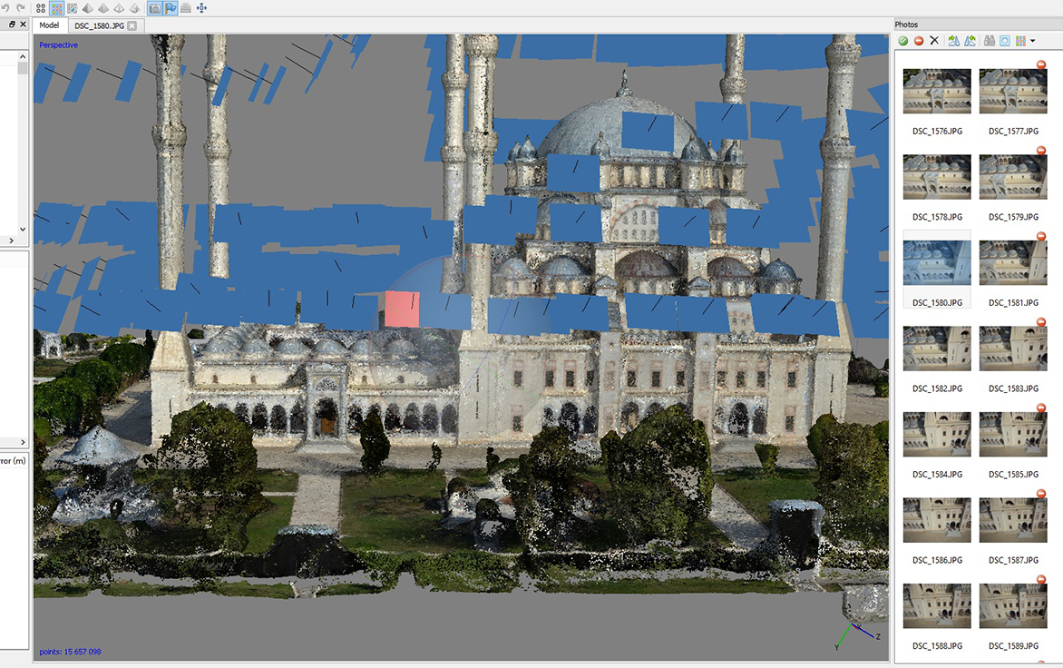
    A high-quality, accurate and professional dataset, HxIP imagery is 30-cm (1-foot) resolution, with set specification and accuracy standards and a regular refresh schedule. The natural color RGB backdrop imagery (tile cache) is fast and easy to access and gives context to survey and construction maps and overlays, Leica Geosystems said. All content is captured using Leica Geosystems airborne sensors for the highest reliability.

    Access to HxIP imagery adds spatial and contextual awareness to surveys, enables better planning and decision-making for more efficient and productive time onsite, and eliminates the need to georeference data to the basemap during post-processing, the company said. Through Leica Infinity software, users can access HxIP imagery to view field measured data and imported design data in the office.

    Users can also prepare job data with the HxIP imagery and then clip and store georeferenced images that can be exported to the new Leica Captivate field software for use as background imagery and basemaps on the newest robotic total stations. The imagery can also be live-streamed to the Leica Zeno 20 handheld.

    The georeferenced HxIP airborne imagery is available to everyone on a subscription basis through the cloud via multiple content service providers, including Esri’s ArcGIS Marketplace, Hexagon Geospatial’s Power Portfolio and Valtus Imagery Services. Complimentary access to live-streamed HxIP image tiles is being offered through June 2016 to customers in the U.S. and Canada that have an active Leica Infinity Customer Care Package (CCP) or that purchase a Leica Zeno 20 handheld.

    “We’re quickly moving toward a world in which every geospatial sensor will have cloud-based access to real-time, high-quality imagery for invaluable survey intelligence,” said Ken Mooyman, president of Hexagon Geosystems NAFTA. “The integration of HxIP with Leica Infinity, Captivate and the Leica Zeno 20 in North America is the first step in bringing that rich, detailed imagery to users where and when it is available so they can be part of leading the way into the future.”

  • Hexagon Geosystems Releases More Airborne Imagery

    Hexagon-imagery

    The Hexagon Imagery Program, or HxIP, has released captured airborne imagery for approximately 25 percent of the U.S. with various regions of Canada and Europe. As more content partners join the HxIP in 2015, program coverage is rapidly increasing with full coverage of the coterminous U.S. expected by the end of the year.

    Launched in June 2014, the HxIP streams valuable geospatial content and delivers professional-grade airborne images captured with Leica Geosystems’ airborne sensors, including enhanced-resolution, four-band orthos, streamable and rasterised point clouds, and stereo imagery, through two service categories:

    • Basemap offers cached background maps of current 30 centimeter orthorectified imagery that will be updated on a regular basis.
    • Multispectral Imagery supports image analysis and exploration activities with 30-centimeter, four-band orthorectified imagery and related digital surface models (DSM).

    Imagery for a full 11 states plus portions of six other states in the U.S. have been provided in the HxIP as part of its airborne imagery offerings from the 2014 flying season. Portions of Canada and Europe are also available in the recent release.

    “We’re pleased to have met our 2014 program goal, providing access to quality and consistent airborne imagery for thousands of clients around the globe,” said John Welter, president of Leica Geosystems Geospatial Solutions Division and director of the HxIP. “We are well on our way of realizing our 2015 goals with collection currently underway in Europe and North America.” 

    The HxIP airborne imagery content is available through the cloud via multiple content service providers:

    Through a distribution partnership with Esri in February, the 2014 collection is now available to even more users on Esri’s ArcGIS Marketplace.   

    “Serving HxIP via Esri’s ArcGIS Marketplace gives geospatial professionals another choice in accessing the most current and accurate geospatial imagery available,” said Juergen Dold, president of Hexagon Geosystems. “The focus of our new partnership is to provide imagery in a simple and efficient way across a wide array of professional consumers.”

    This vision was reinforced by Esri Director of Imagery Lawrie Jordan. “Leica Geosystems is recognized globally as providing the highest quality and most accurate airborne imagery available, and Esri is delighted to offer this content to GIS professionals through our ArcGIS Marketplace,” Jordan said.

  • Leica Offers New ScanStation, Software for 3D Laser Scanning

    Leica-scan-station_p40-p30-p16_07-W

    Leica Geosystems has announced a group of six major new products for terrestrial laser scanning: three new laser scanners and three new point cloud software products. Together, thes products raise the industry’s bar for laser scanning data quality and productivity, both in the field and the office, Leica said.

    Leica ScanStation P40, P30 and P16 Laser Scanners. Leica ScanStations P40, P30 and P16 feature advances in LIDAR and digital imaging as the eighth-generation of Leica Geosystems’ high-performance laser scanners. These new, ultra-high-speed scanners increase field and office productivity, while simultaneously grabbing users’ attention with strikingly sharper, crisper scans and HDR true color images — even under many conditions traditionally difficult for scanning, the company said.

    Users will be able to capture more useful data from a single set-up, which translates into fewer instrument setups and greater productivity. Three models meet different user needs: the Leica ScanStation P40 and P30 add survey functionality, longer range capabilities (to 270m for P40), and advanced scanner controls for additional versatility and productivity while the Leica ScanStation P16 is a short-range introductory model.

    Point Cloud Software. In addition to the major new software releases Leica JetStream and TruView Global products, Leica Geosystems is now offering Leica CloudWorx for Navisworks — a popular design review application from Autodesk — as its newest family member of CloudWorx plug-ins for CAD and VR applications.

    leica-cloudworx

    JetStream is a combined project data vault and high-performance data streaming server that takes Cyclone data and serves it up in a high-performance format that enables a CloudWorx user to be up to 40 percent more productive when working with point clouds. Much of that gain comes from instantaneous loading and navigation of point clouds — eliminating traditional “waiting times” long associated with point cloud office work.

    Lastly, TruView Global greatly increases anyone’s access to TruViews — Leica Geosystems’ application for viewing and measuring scans. Shaking free from prior constraints, TruViews will be accessible within any Internet browser on any mobile device or computer, with no app or plug-in to install.

    Taken together, advances in the new scanners and software elevate laser scanning to a new performance and data quality level, Leica said. The new scanners are all ultra-high speed (up to 1 million points/sec) and can capture more useful data from a scene. In addition, increased user access to TruViews plus good HDR digital images will encourage users to publish TruViews even more frequently.

    All of these factors drive users to create more dense scans and larger data sets. With the complementary Leica JetStream software, users have the ability to handle these larger data sets with astonishing ease.

    The Leica ScanStation P40, P30 and P16 are immediately available. Leica JetStream, Leica TruVeiw Global and Leica CloudWorx for Navisworks are planned for release Q2 2015.

    Photos: Leica Geosystems

  • Topcon, Leica Sponsor REAL 2015 3D Sensor Conference

    REAL 2015: Capture, Compute, Create will be held Feb. 25–26 at Fort Mason Center in San Francisco. REAL is designed to explore the professional 3D sensing, creation, and visualization industries. It includes an executive summit and a world’s fair of cutting-edge 3D demonstrations, and is organized by Autodesk.

    According to organizers, “From drones to autonomous cars, industrial robots to major engineering works, and game consoles to tomorrow’s mobile phones, 3D sensors are suddenly everywhere. And several decades after first grabbing headlines, VR and 3D printing are hot again, attracting billions in investment, and moving beyond early adopters to professionals. But it is the sum total, where sensing meets making, where big change is brewing.”

    Sponsors include Leica Geosystems and Topcon. Two Topcon experts will speak at the event: Jason Hallett, Topcon vice president of global product management, and Eduardo Falcon, executive vice president and general manager of the GeoPositioning Solutions Group.

    “The Topcon line of advanced 3D imaging and mapping technologies are designed for a wide range of geospatial applications providing data-rich results,” Falcon said. “REAL 2015 presents opportunities to explore how our mobile and static scanning solutions can be utilized in forward-thinking ways, as 3D sensing and reality capture continue to permeate traditional and non-traditional industries alike.”


  • Leica Offers DISTO E7500 for Simpler Outdoor Distance Measurement

    The Leica DISTO E7500 laser distance meter.
    The Leica DISTO E7500 laser distance meter.

    Leica Geosystems has released the Leica DISTO E7500 laser distance meter, a tool for anyone who needs easy, precise measurements outdoors. An advanced digital Pointfinder and 4x zoom enables users to take measurements with high accuracy up to a 500-foot range in all light conditions. This capability is a distinct advantage when working outside in sunny weather; even if the red laser point is no longer visible, the target can easily be seen on the tool’s full-color display, Leica said.

    The housing and keypad are sealed against water and dust, and certification to the rigorous IP65 rating allows use in adverse weather conditions. It can also be cleaned under running water.

    A Smart Horizontal Mode enables the DISTO E7500 to provide an accurate result even when encountering obstructions such as walls, hedges or people. One measurement to the target is enough for the required horizontal distance to appear on the display, Leica said.

    Other capabilities include automatic calculation of volumes or areas, two programmable favorites keys, timer delay, a 30-position memory, an offset function, and 15 options for units of measure.

    The Leica DISTO E7500 is certified to ISO Standard 16331-1 for precision and performance in everyday use on the jobsite.

  • The Business — January 2015

    The Business section from the January 2015 issue. Download the PDF.

    Includes:

    • CSR Preparing for Large Indoor Location Market
    • FAA Grants UAS Exemption to Trimble Navigation
    • Leica’s GNSS Unlimited Allows for Upgrades
    • Broadcom Launches Location Hub with Galileo Support for Smartphones
    • SkyTraq GNSS Receiver Module Provides Indoor/Outdoor Positioning
    • Briefs
  • UAV Creates 3D Model of Largest Mosque in Turkey

    UAV Creates 3D Model of Largest Mosque in Turkey

    Turkey-mosque_adana_W
    Photo: Leica

    The Sabancı Merkez Mosque in Adana, Turkey, has been inspected and mapped by an unmanned aircraft system and a detailed 3D model created. The work was carried out by SISTEM A.S. (the Turkish distributor of Leica Geosystems), NRJ Engineering and Aibotix.

    Sabancı Merkez Mosque is the largest in Turkey, with six minarets, four of which are 99 meters high. The largest of its five domes is 32 meters in diameter and 54 meters high, so determining the actual state of the building using conventional methods would be time consuming and costly. Instead, the authorities commissioned a UAV inspection.

    “We needed only three flights to cover all relevant areas and generate comprehensive data,” said SISTEM A.S. employee Bora Yavuz, who has been working with terrestrial laser scanning systems for the past five years. “Compared to laser scanning, collecting the data from the top sections of this huge building by UAV was extremely easy, since nobody had to climb up to the minarets or dangerous places on the domes and wait for the machine to scan. Furthermore, alongside the data registration the generation of point clouds runs automatically.”

    During the flight over the roof of the mosque, the UAV followed a defined route that had been planned on the computer beforehand. The pilot then steered the UAV manually in two more flights around the building.

    The Aibot X6 was carrying a Nikon Coolpix A digital camera and created high-resolution photos with an 80 percent overlap. Using live images from the UAV’s perspective that were sent directly to the screen of a ground station, the pilot could make sure that all relevant areas were captured, and achieve the best possible results by adjusting the camera to the optimum angle during the flight.

    The data was subsequently processed to create an accurate 3D model of the mosque with a precision down to 1-2 centimeters. The high-resolution photos are linked to the model so that damage can be located accurately, with GPS information synchronized with the images for fast post-processing. The images and the model will now be used as the basis for maintenance and repairs.

    Turkey-mosque_adana_2-W Photo: Leica
    Photo: Leica
    Turkey-mosque_adana_3-W
    Photo: Leica
  • Leica’s GNSS Unlimited Allows Upgrades for Reference Receivers

    Leica Geosystems has extended its Spider product family with the new GNSS Unlimited for the Leica GR10 and GR25 GNSS receiver series, allowing receivers to be upgraded to the latest technology standards at any time. Both receivers are designed for Continuously Operating Reference Stations (CORS) infrastructure and monitoring applications, supporting GPS, GLONASS, Galileo, BeiDou and QZSS.

    Also, the classic Leica GRX1200+GNSS has been enhanced to support the Chinese BeiDou navigation system.

    The Leica GR10 and GR25 Unlimited are scalable reference receiver and server solutions designed for permanent and semi-permanent GNSS network installations and monitoring applications such as RTK and static networks, single base stations, field campaigns, structural monitoring, atmospheric and seismic studies and offshore positioning.

    One customer, the Michigan Department of Transportation (MDOT), took advantage of the future proof concept to provide cost-efficient and reliable data products for all its CORS users. MDOT has been working with Leica Geosystems since the beginning of 2000.

    “Leica Geosystems’ customer commitment and promise of future proof hardware guarantee has always ensured our investment remains current,” said Shawn Roy, statewide survey equipment development manager at MDOT. “Their promise has allowed MDOT to upgrade, modernize, and expand our network from the early GRX1200’s (GPS-only) in 2005 to the latest GRX1200+GNSS. The company’s continuous development for hardware and software on our GRX1200 family of devices has helped MDOT over the past 10 years to provide cost-efficient and reliable data products for all the users of the Michigan Spatial Reference Network and other affiliated partners, such as NGS and its data products.”

    GNSS Unlimited. High-precision GNSS users are faced with an ever-changing GNSS space segment, due to its modernization. According to Leica, the GR10 and GR25 receivers provide a safe and long-term investment for CORS operators and fully support the Chinese BeiDou and Japanese QZSS systems, as well as GPS, GLONASS, and Galileo. The GNSS Unlimited series includes an upgrade to more than 500 channels that will serve the users’ needs well beyond 2020.

    Both receivers allow an upgrade of all key hardware parts, such as tracking, memory, power and communications. This enables customers to always keep up with the latest technology advances at minimum cost and only when really needed. The GNSS reference receivers act just like a data center server that satisfies all needs for a reliable operation, such as backup power supplies, redundant data communications, secured access and an easy way to monitor all the servers’ activities.

    GRX1200+GNSS. First introduced a decade ago, the GRX1200 series is an example of Leica’s future-proof design with a newly released option to track the signals of the Chines BeiDou navigation system. Since 2004, customers have relied on the sensor’s innovation, allowing them to maintain and increase the value of their initial investment, Leica said.

  • Leica, Aibotix, and Headwall Offer Airborne Sensor Solution

    The Airbotix X6.
    The Aibotix X6.

    Leica Geosystems, Aibotix and Headwall Photonics are offering an integrated high-performance airborne sensor solution using a hyperspectral imager and the Aibot X6 unmanned aerial vehicle (UAV). The Nano-Hyperspec sensor is optimized for size, weight and power to enable aerial acquisition of all spectral and spatial data within the scene of interest. A UAV with integrated Headwall sensor has been successfully flown and was presented at InterGeo 2014, held last week in Berlin.

    Precision agriculture, forestry, geological research, and environmental monitoring are application areas that can benefit from the airborne hyperspectral imaging solution, the companies said. Equipped with the hyperspectral imager, the Aibot X6 can, for example, take pictures of fields or vineyards to determine the chlorophyll content, plant health, and invasive species, and offer farmers information on the state of the plants and harvest. By means of UAV and hyperspectral imager, farmers can measure before harvest, where the grain is driest or should be mowed first. Or, they can determine where rain has washed away fertilizer and where they must re-fertilize.

    For geological mapping, landfills and open mine sites can be overflown to quickly and efficiently track precious metals or minerals. Environmental monitoring and research to derive contamination of soil or water can be determined spectrally from the air quickly using the Aibotix UAV and Nano-Hyperspec sensor.

    The Nano-Hyperspec sensor measures 76.2 x 76.2 x 119.4 millimeters and weighs less than 0.68 kg. The sensor is integrated with a high-speed data processor and high-capacity flash storage. It collects image data across 640 spatial bands and 270 spectral bands with a Visible-Near-Infrared (VNIR) range of 400-1000 nm. The field of view is exceptionally wide, meaning that flight swath efficiency is maximized to cover as much territory as possible while the UAV is aloft. Further, it delivers crisp image data not only directly underneath the flight path but off to the edges.

    The integrated data storage is 480 GB, which will yield more than two hours at a frame-rate collection rate of about 100 fps, which is matched to the actual performance of the UAV itself. The direct-attached GPS with IMU yields the ability to generate ortho-rectified imagery data products.

    The Nano-Hyperspec comes pre-loaded with an airborne version of its Hyperspec III application software that manages sensor operation, image acquisition, and sensor performance while aloft. Hyperspec III software is designed to work in a complementary fashion with the GPS/IMU as well as incoming LiDAR data to collect spectral data and generate a completely integrated hyperspectral data cube.

  • Icaros to Unveil Versatile Nadir/Oblique Aerial Mapping System at InterGeo

    Icaros, Inc., a provider of aerial remote sensing and 3D visualization solutions, will unveil the IDM 1000 digital oblique mapping system next week at the 2014 InterGeo Conference in Germany. The versatile Icaros Digital Mapper (IDM) 1000 combines a high-accuracy photogrammetric nadir camera with four high-quality oblique sensors in a modular airborne imaging package.

    “Icaros developed the IDM 1000 for mapping organizations that want to maximize their investment in an aerial sensor system,” said Tom Bosanko, CEO of Icaros. “The IDM 1000 can be configured to meet the geospatial application needs of traditional photogrammetric imaging as well as 3D oblique mapping, all in one flexible system.”

    Icaros will display the IDM 1000 in booth #A4.009 Hall 4.1 at the InterGeo Conference and Trade Fair being held in Berlin October 7-9.

    The modular IDM 1000 package is built around the IDM 200 nadir camera with a new mount supporting up to four 45-degree oblique sensors. The standard IDM 1000 configuration includes an 80-megapixel (MP) nadir natural-color (RGB) sensor, four 36-MP oblique RGB sensors, modular mount, embedded GPS/INS, flight planning and management system, and the Icaros Photogrammetric Suite (IPS) of software tools.

    “Clients have the option of purchasing the IDM 1000 as a complete solution,” said Bosanko. “Or they can buy and operate the IDM 200 as a stand-alone unit and add the oblique cameras and mount later as their mapping offerings expand to include 3D modeling and oblique visualization.”

    The IDM camera family offers eight sensor-design alternatives, including near infrared and thermal infrared imaging. Each IDM camera delivers sub-pixel accuracy, high-dynamic range and true-color pixel collection. Depending on altitude, the pixel GSD ranges from 1 cm to 100 cm in nadir or oblique operations. The IDM 1000 can be flown on rotor or fixed wing aircraft and modified for flight on some UAVs.

    Aerial oblique imagery is used extensively in tax appraisal and assessment, and its applications are expanding rapidly into facility management, infrastructure monitoring, building energy audits, public safety and other GIS markets that benefit from creation of accurate 3D models and elevation data sets. The IDM 1000 is considered ideal to serve in the energy, utility, oil & gas, mining, urban development, security and defense markets.

    “The IDM 1000 package includes all of the software needed to process nadir and oblique imagery and perform advanced photogrammetric measurements,” said Bosanko. “The new Icaros Measurement Tool (IMT) is included.”

    The IMT is a universal oblique measurement tool. It enables customers working within Esri’s GIS environment to view and measure structures in oblique aerial imagery captured by any commercial oblique sensor system, including those from Pictometry, Vexcel/Microsoft, IGI, Leica, and Midas. IMT works equally well measuring images captured by oblique sensors mounted on unmanned aerial vehicles (UAVs).

    As GIS users continue the move to 3D, oblique imagery will be critical for constructing accurate image-based realistic 3D models. IMT enables users to manipulate and view oblique imagery while leveraging other geospatial data layers within their GIS environment. This capability allows users to navigate multi-image scenes in three dimensions while zooming and panning.

    The IMT software will also be demonstrated in the Icaros booth at InterGEO.


  • Slideshow: 2014 Esri User Conference

    GPS World is at the 2014 Esri User Conference, being held July 14-18 in San Diego. Check out our slideshow for key photos from the first day of the conference. Follow tweets from GPS World and Geospatial Solutions for live updates from the conference.


  • Pegasus:Two Mobile Mapping Contest Deadline Extended

    Because of overwhelming interest in the Pegasus:Two Mobile Mapping Contest, the Leica Geosystems Mobile Mapping team has announced an extension of the contest deadline. Entrants now have until August 31, 2014, to submit their detailed proposals and project timelines.

    “We are very excited about the interest shown in the Pegasus:Two mobile mapping solution and the resulting enquiries into the contest,” says Stuart Woods, project manager at Leica Geosystems. “Extending the contest deadline provides potential entrants with more time to create and prepare their entries. There are many fantastic ideas developing throughout the world and we’re extremely curious to learn about them.”

    The winner of this contest, who will receive free use of a Leica Geosystems’ Pegasus:Two mobile mapping system for six months plus $10,000 USD to spend on the project, will be announced on September 8.