Livox Technology Company has introduced two high-performance, mass-produced lidar sensors, the Horizon and Tele-15, which feature a new scanning method that offers improved sensing performance at a low cost.
The lidar sensors are aimed at L3/L4 autonomous driving, smart cities, mapping, mobile robotics and more.
“The growth potential of the lidar industry has been hindered for too long by ultra-high costs and slow manufacturing rates,” said Henri Deng, global marketing director at Livox. “Livox seeks to change this by providing access to high-quality lidar systems that are easily integrated into a wide array of different use applications. Through our technology, we hope to be the catalyst for the rapid adoption of lidar in the quickly growing industries of autonomous driving, mobile robotics, mapping, surveying and more.”
The environment scanned by a Livox sensor increases with longer integration time as the laser explores new spaces within its field of view (FOV). A Livox Mid-40 or Mid-100 sensor generates a unique flower-like scanning pattern to create a 3D image of the surrounding environment.
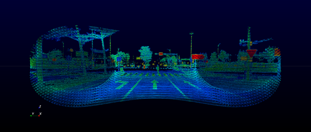
Horizon point cloud sample of crossroads with a pedestrian crossing the street. (Image: Livox)
Image fidelity increases rapidly over time. In comparison, conventional lidar sensors use horizontal linear scanning methods that run the risk of blind spots, causing some objects in their FOV to remain undetected regardless of how long the scan lasts.
The non-repetitive scanning method of the Livox lidar sensors enables nearly 100% FOV coverage with longer integration time.
The Horizon and Tele-15 are high-performance lidar sensors designed for L3/L4 autonomous driving applications. The Horizon has a detection range of up to 260 meters with a horizontal FOV (HFOV) of 81.7° which can cover four road lanes at a distance of 10 meters. Its FOV coverage ratio is comparable with a 64-line mechanical lidar at the integration time of 0.1 sec. Using five Horizon units enable full 360° coverage.
Made for advanced long-distance detection, the Livox Tele-15 offers the compact size, high-precision and durability while vastly extending the real-time mapping range. The Tele-15 can scan 99.8% area within its 15° circular FOV at 0.1s.
The Tele-15 can successfully detect an object up to 500 meters away. As a result, Tele-15’s performance allows autonomous driving systems to detect remote objects well in advance, providing more reaction time even at high speeds.
This image shows the Global Ecosystem Dynamics Investigation Lidar (GEDI) being assembled NASA’s Goddard Space Flight Center. (Photo: NASA)
Under a contract with the University of Maryland, Ecometrica, a sustainability and space data company, will be helping disseminate data from NASA’s latest “Global Ecosystem Dynamics Investigation” (GEDI) lidar instrument.
According to Ecometrica, the Ecometrica Platform will make processed maps more widely available to end users and reduce the need for additional processing of highly technical remote sensing lidar data.
GEDI is led by the University of Maryland, in collaboration with NASA Goddard Spaceflight Center, and deploys a multibeam lidar instrument onboard the International Space Station to measure the forest vertical structure and biomass. Carried from Earth to the International Space Station atop a reusable SpaceX Falcon 9 rocket, it is already providing valuable raw data, which will be crucial in better understanding climate change and the Earth’s ecosystems, Ecometrica said.
“The value of downstream satellite data in managing climate and environmental risks is significant and it is important that this is available and easily accessible to users all over the world,” said Richard Tipper, executive chairman at Ecometrica. “Projects such as Forests 2020, the global forest monitoring initiative that is part of the U.K. Space Agency’s international program, and managed by Ecometrica, are already proving very successful in using data from space to protect ecosystems on Earth. Importantly, this has also helped create an international skills-base and infrastructure across tropical forest countries, which can now benefit from the results of the very latest Earth observation instruments from NASA.”
The lidar instrument is operated by the university, which is working with Ecometrica to make data available globally in a format that is easy to use for environmental monitoring and protection purposes. According to Ecometrica, its platform will display key findings on rapidly updating maps, allowing conservation organizations and government agencies around the world to tap into the findings and use the real-time data to monitor forest canopies and cover.
The partnership is set to continue as part of the latest three-year contract.
This image of Wales is color-coded to show the relative height of the land. (Image: Bluesky)
Aerial mapping company Bluesky International has been awarded a contract by Natural Resources Wales, on behalf of Welsh Government, to capture a high-resolution laser mapped aerial survey of the whole of Wales.
Working alongside Natural Resources Wales and the Welsh government, Bluesky will capture the data at a resolution of 2 points per metre before processing and delivering lidar data for more than 20,000 square kilometers of rural and urban landscapes.
The Bluesky lidar data will be employed in a range of policy areas including flood modeling, forestry management, coastline monitoring, urban planning and archaeological conservation.
In addition to use internally by Welsh Government and Natural Resources Wales, the lidar data will also be made publicly available in due course, via Welsh Government’s Lle Geo-Portal website and Bluesky’s Mapshop.
“Historically, lidar data has been acquired over Wales at various points in time from the 1990s onwards,” said Paul Isaac, project manager at Natural Resources Wales. “However, since these datasets have been collected for different reasons a patchwork of data exists that is inconsistent in terms of capture technology, coverage and resolution. Also, many of the high-altitude, mountainous areas have not been captured at all resulting in key habitats and ecosystems remaining unmapped.”
“This pattern of largely uncoordinated acquisitions would likely have continued with different programmes and projects funded from various sources,” he added. “Therefore, rather than different public sector bodies securing data individually — leading to inefficiencies and discrepancies — Welsh Government proposed to capture one consistent dataset to cover the whole country. A further key driver for the projects is the wider economic benefit as organizations and individuals will no longer have to fund separate data capture.”
Bluesky was awarded the National Lidar for Wales contract following a formal tender process with responses evaluated on technical ability as well as price. All tenders were required to provide a detailed methodology of how they would complete the project to the published specification.
“Bluesky was able to provide evidence that they could provide the required services at a competitive price,” Isaac said. “Bluesky also showed they had extensive experience in this field having successfully delivered a number of related projects.”
“We are delighted to be working with Natural Resources Wales on this nationally significant project,” said Rachel Tidmarsh, managing director of Bluesky International. “As a team, we have great experience delivering large scale projects of this nature to the required specification and timescales.”
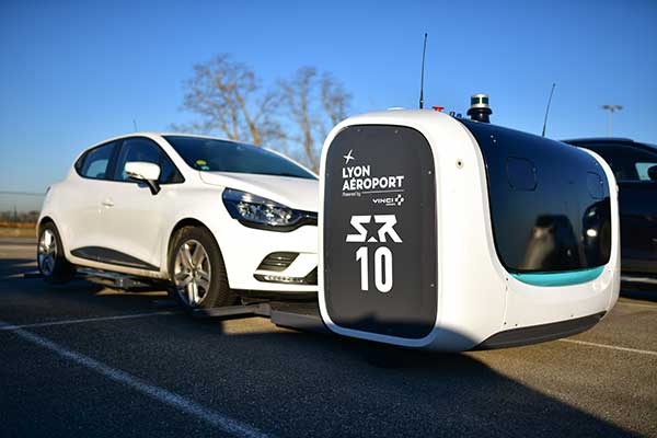
Stan servicing vehicles at the Lyon Airport. (Photo: Stanley Robotics)
Stan incorporates the Trimble BX992 dual-antenna enclosure for accurate, available and reliable localization
The Stanley Robotics team has called on Trimble to equip Stan, its autonomous parking and valet robot, with accurate localization.
To achieve centimeter-level localization, Stanley Robotics needed to combine perception algorithms and intelligent management software with reliable GNSS technology.
“The robot must move fast to handle high traffic flow and precisely to park cars as densely as possible,” said Anthony Troublé, robot team manager at Stanley Robotics. The team selected the Trimble BX992 dual-antenna enclosure and two Trimble AV59 GNSS antennas.
The BX992 is installed inside the robot and the two antennas are mounted on the robot’s head with maximum separation between them. For the robot to attain centimeter-level localization, a Trimble BX992 base and a Trimble Zephyr antenna are installed at the drop-off cabins where customers leave their cars until robots move them to a more permanent location.
The Trimble BX992 base broadcasts real-time kinematic (RTK) corrections over a Wi-Fi link to the robots.
What Stan Does
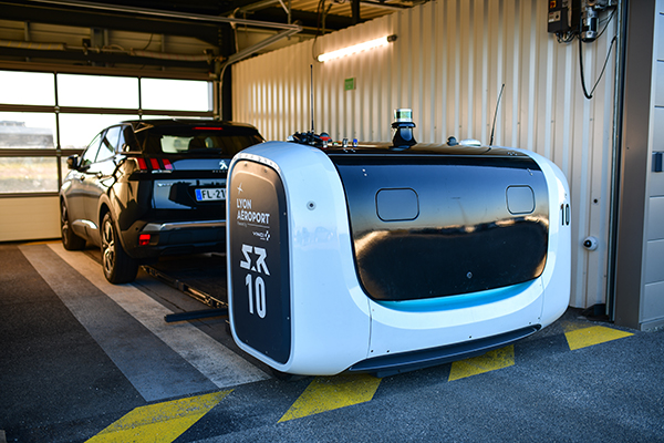
Photo: Stanley Robotics
With the Stan robotic valet, passengers no longer waste time looking for a free space or trying to locate their vehicle, according to Stan’s creators. After booking their parking space in just a few clicks on the Lyon Airport website, passengers drop off their vehicle in dedicated cabins and make their way to the terminals using the shuttle bus located just a few steps away.
The robot takes care of the car, parking it in the secure car park. When they return, passengers pick up their vehicle, which is waiting for them in one of the cabins.
“The service offers security, simplicity and time savings. With this new technology, parking becomes a no-fuss experience that takes only a few minutes of passengers’ time, leaving them free to travel in a relaxed state of mind,” Stanley Robotics said in a press release.
The system also constitutes a new way of arranging vehicles in a car park and makes excellent use of space since cars can be parked in dense blocks.
In addition, the robot uses two lidar scanners and four cameras. Stan relies on lidar-based simultaneous localization and mapping (SLAM) techniques to locate the robot and build a map. The lidar-based SLAM system is always running and is fused with the GNSS localization and odometry.
“The lidar is mostly critical in the cabins where the GNSS availability and reliability is not sufficient,” Troublé said. “The full integration with our localization system, especially the transition from indoor-to-outdoor when the robot enters a cabin was a challenge. We have tuned and improved our localization fusion algorithm to get the best out of each component and deliver a consistent confidence index.”
Stan is equipped with three levels of safety to ensure operational effectiveness.
First, Stanley Robotics continuously monitors the accuracy, availability and consistency of the RTK GNSS, SLAM and odometry localization signals. “If these signals are too inconsistent or if the overall confidence is too low, the robots are stopped and a site supervisor is alerted,” Troublé said.
Further, the site is monitored through lidars and cameras on the robot to prevent any collision with obstacles.
Finally, a trained Stan maintenance worker is assigned to every parking lot. These individuals wear a safety badge. Every robot is equipped with a safe-stop feature that will trigger if the operator gets within a defined proximity to the robot.
The first outdoor car park managed by robots opened to the public in 2018 at Lyon Saint-Exupéry airport. Since testing started in 2017, four Stan robots are now fully operational in the Lyon Saint-Exupéry airport car park, which can accommodate up to 500 vehicles.
Stanley Robotics announced in January 2019 that they will open 2,000 spaces at Lyon in the summer of 2020. The airport is looking to eventually expand this system to up to 6,000 spaces in total.
In 2019, Stanley Robotics signed a contract with Gatwick Airports, the first U.K. airport to use robots that valet park passengers’ cars. The Stanley Robotics team is gearing up to begin work at another airport to be announced soon.
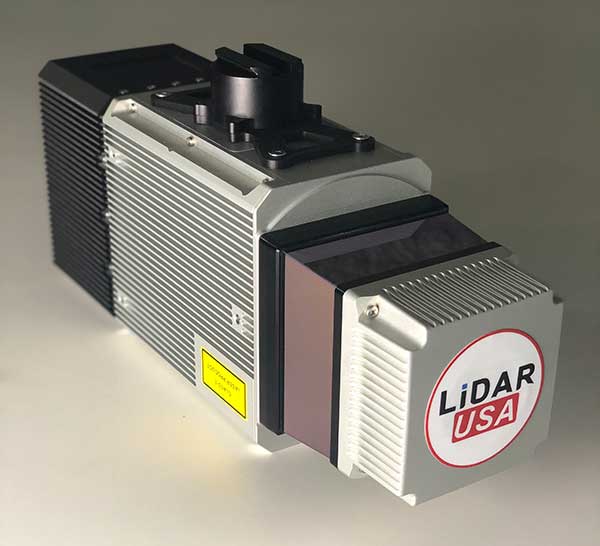
The Snoopy CL-360 lidar scanner. (Photo: Lidar USA)
The Optech CL-360 has joined the ranks of Lidar USA Snoopy systems.
The Snoopy CL-360 has been meticulously designed for integration on backpack, vehicle and UAV applications. Weighing 5 kilograms fully assembled, the Snoopy CL-360 is capable of delivering highly accurate results, up to +/-0.01 feet on paved surfaces from a vehicle.
The system has a scan line rate of 250 Hz with a 500-kHz data rate, giving a uniform result along and across track. The systems are easily configurable with multiple scanners (similar to internet of things applications) to avoid occlusions.
“We are pleased to again partner with LidarUSA in their innovative approach to UAV integration with the addition of our CL-360 to their product portfolio. Featuring true 360-degree scanning without blind spots, CL-360 integrated by LidarUSA will provide an exciting addition to the UAV marketplace,” said Optech Executive Vice President and General Manager Michel Stanier.
Users can also benefit from a UAV deployment, achieving scans with usable data as much as 60 degrees off nadir (widths of more than 1,100 feet while scanning at the 400-foot ceiling). The small beam size of 0.3 mrad allows the CL-series to reliably collect ground points (such as on or near the dirt through vegetation) while also providing better detection of fine linear features such as power lines and railroad tracks.
The integration of the CL-360 into the Snoopy series of systems from Lidar USA is expected to be a huge plus to the mapping community in 2020, according to Lidar USA. Users can expect to see the benefit of decreased field-collection effort and increased product quality resulting in a growing and profitable business.
“As more technologies embrace lidar collection to reduce their field time, we expect to see the CL-series become the ‘go to’ solution for many of them,” said Jeff Fagerman of Lidar USA. “The CL-series provides the accuracy and point density often necessary to meet the client’s every growing demands for more, more, more. By designing the system for car and UAV, as well as multiple configurations (two or more systems running together), our users will greatly benefit where they feel it most — the bank.”
Earlier this year, a drone pilot and two data scientists from PrecisionHawk traveled to the Philippines for a unique mission — to fly drones equipped with lidar sensors over a dense rainforest to map ancient trade paths. The aim was to find buried treasure left by the Japanese during World War II.
PrecisionHawk was approached by the producers of a new History Channel show to help them navigate the Filipino rainforests. Through the combination of air and ground sensors, including a DJI M600 UAV equipped with a Riegl miniVUX lidar sensor and a Sony a6000 camera, PrecisionHawk staff produced a colorized 3D map of the forest.
The History Channel aired the series premiere of “Lost Gold of World War II” on March 19, 2019; all eight episodes are now available for streaming. The second episode features visuals generated by PrecisionHawk, as well as interviews with the drone pilot and data scientists.
How AI and machine learning algorithms redefine the way utility companies manage their infrastructure
By Jaro Uljanovs, Lead AI Developer and Data Scientist, Sharper Shape
Artificial intelligence (AI) boasts a wide range of potential applications, across nearly every industry imaginable — healthcare, automotive, retail, even fast food. But it’s the utility industry where AI and machine learning (ML) are beginning to demonstrate some of their most impactful effects on many aspects of the business. Power companies are increasingly leaning on AI to improve their electricity delivery and prevent potential wildfires, and AI is actually enhancing, rather than eliminating, human jobs.
From data collection and analysis to their presentation of actionable insights, AI and ML algorithms are quickly redefining how utility companies manage their electric infrastructure.
Consolidating and classifying data
Utility companies oversee massive infrastructure networks, comprising poles, conductors, substations and transmission and distribution lines that span thousands of miles. The vegetation surrounding this key infrastructure must also be monitored, as it presents a danger of fire or outage.
Taking a comprehensive snapshot of these assets means utilizing a variety of different sensors for network inspections. These sensors include lidar, color (RGB), hyperspectral and thermal imagery.
This allows the system to capture everything — from vegetation proximity, to infrastructure assets, to individual components (such as insulators on poles) and their operational integrity, to hot spots indicating potential fire risks.
That’s a lot of data to capture, catalog and process. And there are a lot of individual elements within that data — even in just one image — to pinpoint and classify, let alone do so accurately. Classifying billions of data points across all of those images is an impossibly time-consuming task to do manually.
Photo: shaunl/E+/Getty Images
AI and ML tools can accomplish that same work — scanning thousands of images collected across thousands of miles of utility infrastructure — in seconds. Lidar point cloud segmentation can detect conductors (quite a difficult component-type to segment) with an accuracy of over 90%, while hyperspectral image segmentation can identify vegetation species with an accuracy of up to 99%.
More than that, when paired with drone sensors, these algorithms can also improve the upfront collection of images and data. AI and ML tools help to adjust sensor positioning in real time, in the event a signal is lost or the drone veers slightly away from its inspection flight path.
By helping to readjust the sensors’ bearings while in flight, AI not only ensures more accurate data collection, but also that the flight doesn’t need to be done again or prematurely ended because of faulty data collection, saving time and money. AI pinpoints any faults in the sensors or the drone’s flight path while in the air, recalibrating as needed and identifying individual elements within the data as it comes through the sensor’s video feed.
Breaking down silos to create a holistic data approach
Key to all of this is eliminating the silos that tend to naturally build up between different data segments. In the utility inspection space, asset management, vegetation management, different sensors and so on all produce their own disparate, walled-off sets of data.
When data is kept siloed like this, it becomes unnecessarily difficult if not impossible for teams to derive companywide insights or conclusions from the information being collected. And what good is all that data if it can’t be used to check against itself and enhance other sets of data?
Good data management can’t exist in a piecemeal approach. It needs to be holistic, and AI provides the impetus to make that happen. AI provides a central resource for pooling all these data sources together, making it easier to cross-analyze for potential problems — like wildfire-prone vegetation or damaged components. When these issues are collected in one system, it becomes much easier to identify faults and resolve them — and do so far faster than it would be to manually sift through countless images of poles or vegetation maps.
And for all the stereotypical concerns about AI eliminating work for human beings, at utility companies AI actually enhances the role that people have to play in the network inspection process. Because the AI is what analyzes the data, it’s not something that is dependent on the potentially biased expertise of a professional human inspector, nor is it prone to fatigue and the anomalous results that can come from that. But at the same time, AI can’t do everything itself. It’s a tool for presenting clearer, more accurate and more actionable information for the people to then act on with their own judgment.
There’s a lot of easy-to-make assumptions, both good and bad, about AI. But at the end of the day, what AI really means for the utility industry is a more efficient and effective tool for providing the right information about a power company’s infrastructure — its transmission and distributions lines, its poles, and its nearby vegetation — into the hands of its key decision makers.
Autonomous vehicle startup announces availability of driving sensing solutions for purchase to OEMs
DeepRoute has released for sale its autonomous vehicle sensing solution, DeepRoute-Sense. DeepRoute is a CES 2020 Innovation Award Honoree.
Photo: DeepRoute
DeepRoute-Sense is an L4-level self-driving full-stalk solution that aims to enable the autonomous vehicle industry to achieve quicker sensor deployment. It includes a sleek, lightweight set-top box and sensor-fusion calibration service.
The roof box consists of GNSS, eight vehicle cameras, three lidars and a series of other sensors to help correspondence and data synchronization between the controllers.
DeepRoute has independently designed the mechanical structure of the roof box, which has outstanding diversion, heat dissipation and sealing functions. The set-top box is lightweight, small and with high impact resistance. With four tripods, the roof box can be easily mounted to the roof of different vehicle models for sensor deployment.
“The team at DeepRoute has worked hard on the development of DeepRoute-Sense and we are excited to finally share our technology with the industry,” said Shuang Gao, COO of DeepRoute. “By bringing this to the market, we are hoping to fuel progress within the industry and bring full vehicle autonomy to be one step closer to the masses.”
The solution uses a DeepRoute-developed in-vehicle camera that features anti-glare, anti-ghosting and highly reliable signal detection. Compared with industrial cameras, the camera comes at a lower cost, but also offers a higher dynamic range.
The roof box has been developed to accommodate different and extreme weather conditions, whether it be during intense sunlight or nighttime high-beam illumination, and can stably handle the exposure and avoid overexposure.
The set-top box includes a sensor data-processing device, the ADS Synchronous Controller. It is pre-processed and fused with the massive data from GNSS, cameras, lidars and other sensors through high-precision time and space synchronization. The ADS Synchronous Controller also supports DNN and SLAM hardware acceleration, which greatly increases computational efficiency.
Teledyne Optech’s new compact lidar sensor, the CL-90, is available for purchase through its first integration partnership with Lidar USA.
For more than 20 years, Lidar USA has been building UAV sensor systems and has sold thousands of systems worldwide. Its ability to support numerous industries with cutting-edge integration makes them an ideal partner for Teledyne Optech’s compact lidar sensors, Teledyne stated in a press release.
Lidar USA’s products are used for surveying-related tasks ranging from topography work, to highways and land development. They are also used for agricultural work for forestry and plant growth, and have applications in archeology as well.
Teledyne Optech’s CL-90 sensor features exceptional canopy penetration for excellent ground coverage, higher downward point density for superior results in corridor/power line projects, long-range performance for maximum productivity at UAS ceilings and best-in-class data precision for tight-tolerance applications, the company said.
“Our customers face many challenging projects and they need tools that can deliver,” said Lidar USA CEO Jeff Fagerman. “Whether it’s greater range, more accuracy or better penetration of vegetation, using the new Optech CL-90 gives us the means of providing the tool to get the job done.”
Teledyne Optech Executive Vice President and General Manager Michel Stanier believes the partnership will help expand both companies’ global presence.
“Teledyne Optech is pleased to partner with Lidar USA to bring our compact lidar sensors to market,” Stanier said. “Lidar USA is a premier UAV solution provider. As a result, we are confident that their integration expertise and strong global market presence will provide the ideal platform to deploy the CL-90’s rich, unique feature set into the UAV marketplace.”
Lidar USA will be at Intergeo this year and can be found at ICS Foyer Stand 2 featuring a fully integrated CL-90 solution. Teledyne Optech will be featuring some of its new Compact Lidar suite of products this year at Intergeo Booth B3. 042 from September 17-19 in Stuttgart, Germany.
Shanghai-based GNSS technology and solutions company Shanghai Huace Navigation Technology Ltd. — known as CHC Navigation — has opened a North American subsidiary, CHC Navigation USA Corporation, in Scottsdale, Arizona.
CHC Navigation was established in 2003 and was ranked as one of China’s top GNSS and RTK technology and solutions companies in 2017. It has customers in more than 100 countries worldwide and has been providing GNSS and RTK products and solutions to the US marketplace since 2009.
The establishment of a North American head office in Scottsdale illustrates CHC Navigation’s ongoing commitment to expanding its products, services and customer support in the U.S. and North American marketplaces.
CHC USA will warehouse, sell and service from Scottsdale all of its products to its dealer and OEM network of customers across North America. With the new U.S. presence, CHC USA will be able to respond more quickly to its dealer and customer order requests and service requirements.
CHC USA specializes in CORS GNSS base-station infrastructure, deformation monitoring, surveying and mapping. With new 3D lidar scanning and hydrographic unmanned survey vessels launching later this year, CHC USA’s North American office and team members will continue to focus on ensuring a great customer experience.
“On the heels of strong CHC Navigation growth in the US in 2018, the time was right to establish a domestic US sales and service office and warehouse with a local team of positioning industry professionals,” said George Zhao, CEO of CHC Navigation. “Our U.S. and Canadian customers have been very supportive of CHC Navigation over the years and our focus will continue to be on providing industry leading products and services to our valued North American dealers and customers,” added Phil Gabriel, President of CHC Navigation USA.
Blue Marble Geographics has released a new version of the Global Mapper software development kit (SDK), providing software engineers with the means to embed the latest geospatial technology into their custom applications.
Blue Marble’s GIS software has been used by GIS professionals for 25 years. Users come from all industries including software, oil and gas, mining, civil engineering, surveying and technology companies, as well as government departments and academic institutions.
Global Mapper’s GIS application is capable of displaying, converting and analyzing virtually any type of geospatial data. The Global Mapper SDK and accompanying Lidar Module SDK provide software developers with a toolkit for accessing much of this functionality from within an existing or custom-built application.
The SDK also enables the creation of custom toolbars and extensions to enhance the data processing and analysis functionality of the standard version of Global Mapper. This capability allows in-house developers to create a unique version of the application to meet their specific needs or for software companies to build custom products for commercial distribution.
Highlights of the latest version of the SDK include:
A new function to allow querying of elevation from a specific list of elevation layers
Significant speed improvements when working with vector data with attributes
Faster viewshed calculation on computers with multiple cores
Support for downloading vector features from Esri RESTful data sources
S-52 point symbols for S-57 and S-63 marine chart files
Updated SHIFT_LAYER script command to support shifting in the Z (elevation) direction.
Support for several new formats including, OpenFlight and HEC-RAS raster and vector files
The supplementary Lidar Module SDK now offers:
The ability to select points based on their proximity to other lidar points and/or line features
A new option to update the return number/count when deleting multi-return points
“Global Mapper’s reputation as a powerful geospatial data processing and analysis application is well known throughout the world and software engineers are increasingly integrating these tools into a wide variety of development projects,” said Patrick Cunningham, Blue Marble president. “The Global Mapper SDK is unrivaled in its ease of deployment, data format support, affordability, and in its adaptability, allowing it to meet the ever-changing needs of today’s geospatial software development sector.”
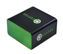
Cepton Technologies Inc., a provider of 3D lidar solutions for automotive, industrial, security and mapping applications, has unveiled its newest lidar scanner, the SORA-P60L.
Part of Cepton’s SORA family of lidar scanners, the new scanner is purpose-built to deliver long-range, high-resolution imaging for unmanned aerial vehicles (UAVs).
The SORA-P60L offers a 400-Hz frame rate, enabling drones to fly faster while maintaining high point-cloud density. With a 550-gram payload, the SORA-P60L prolongs UAV flight time allowing more ground to be covered in a single trip, the company said.
Cepton’s unique Micro-Motion Technology faces all lasers downward at all times, providing a dense, uniform point cloud that, in combination with the high scan rate, makes it suitable for fixed-wing and fast-moving rotary-wing UAVs.
“Cepton’s SORA-P60L leads the lidar industry with its best-in-class point cloud density that provides superior imaging for UAVs,” said Neil Huntingdon, Cepton’s VP of business development. “With the affordable price point, long-range capabilities and high frame rate of SORA-P60L, UAVs can capture data faster and build more accurate maps. SORA-P60L is our first product from the SORA family that we have unveiled this year. We see a lot of opportunities for this unique sensor in other markets and have a number of products in development that will be revealed later this year.”