The rapid growth of autonomous military systems is creating a new challenge for the defense industry, working to keep equipment operating when navigation becomes unreliable.
Across recent conflict zones and contested regions, GNSS disruption is affecting UAVs, loitering munitions, ISR platforms, maritime systems and autonomous ground vehicles.
“InfiniDome is expanding its vision beyond GNSS protection, toward a future of mission continuity and navigation awareness in contested environments,” the company stated.
The statement reflects a broader trend across the defense autonomy sector. While anti-jamming technologies were once treated primarily as protective add-ons, many military programs are now integrating navigation resiliency into wider autonomy architectures. The result is a growing shift in how autonomous systems are evaluated.
Rather than focusing solely on navigation accuracy or platform performance, defense organizations are increasingly asking whether autonomous systems can maintain operational continuity under degraded or denied conditions. Industry observers note that this transition is particularly evident in the loitering munition and tactical UAV sectors, where survivability in contested environments is becoming a baseline operational requirement.
At the same time, low-SWaP anti-jamming capabilities are becoming more common across the market, increasing pressure on companies to differentiate beyond hardware alone. That pressure appears to be accelerating a broader industry movement toward what some describe as “navigation awareness,” the ability not only to withstand interference, but also to understand and react to the electromagnetic environment in real time.
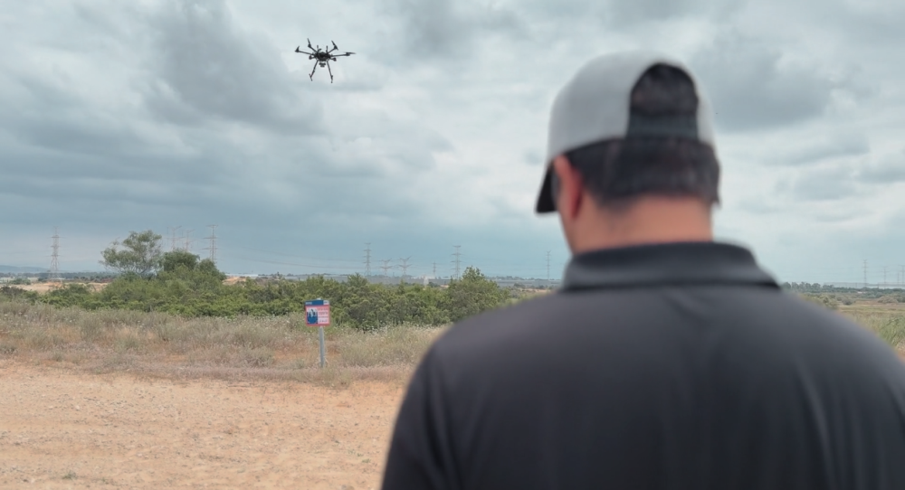
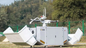
InfiniDome is expected to demonstrate this direction during the exhibition through IroNav, developed jointly with Wonder Robotics. The demonstration will include autonomous operation streamed live from a jammed environment in Israel, showcasing navigation resilience capabilities under active interference conditions.
The live demonstration comes as European defense programs continue increasing investments in autonomy, tactical drones, and resilient battlefield systems amid growing concerns surrounding electronic warfare and GNSS vulnerability.
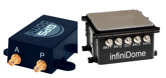
InfiniDome is set to debut its Aura GNSS protection system at XPONENTIAL Europe in Düsseldorf, Germany, March 24-26.
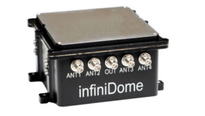
Aura supports two to four antennas and protects two GNSS frequency bands while passing two additional bands. The system can generate up to three nulls per protected band, allowing it to suppress multiple interference sources at once. The product is offered in two configurations: an enclosed version weighing 500 grams and an OEM version at 375 grams, the latter designed for integration into platforms where size and weight are constraints.
The company will also present IroNav, a navigation solution developed jointly with Wonder Robotics that combines InfiniDome’s anti-jamming technology with Wonder Robotics’ visual navigation and autonomy software. The layered architecture is intended to keep autonomous systems navigating when GNSS signals are degraded or unavailable entirely. IroNav is also making its European debut at the show.
InfiniDome recently entered the Indian market through a partnership with Globaz Technologies, which will serve as the company’s official partner in the country. The agreement is aimed at addressing demand for navigation resilience technology in India’s defense and unmanned systems sectors.
XPONENTIAL Europe is scheduled to take place this month in Düsseldorf, Germany.
infiniDome has introduced Aura, a new GNSS protection system built for platforms that cannot afford to lose their way. According to the company, this development comes at a time when GNSS interference incidents have surged by more than 400% across Europe and the Middle East over the past two years, making uninterrupted navigation a strategic necessity.
Developed from years of field-proven operational experience, Aura is designed to redefine navigation resilience with smarter algorithms, faster interference response and a compact, rugged design capable of operating in contested environments.
The system is available in two configurations: Aura, the enclosed version for rapid deployment, and AuraCore, the OEM module for integration. The system brings mission-grade protection to platforms ranging from small UAVs to large autonomous vehicles.
Among several new capabilities, Aura features enhanced null-depth performance, enabling the system to withstand higher jamming power, and a new saving power mode that dynamically reduces energy consumption when no interference is present.
“Aura isn’t just an upgrade; it’s a new philosophy,” said Omer Sharar, CEO of infiniDome. “It takes everything we’ve learned from real-world interference events and transforms it into a smarter, faster and more adaptive layer of defense. With Aura, we’re not just protecting GPS; we’re protecting autonomy itself.”
Engineered for modern battlefields and complex environments, Aura introduces a new level of performance and resilience.
Its adaptive algorithms ensure reliable navigation under evolving jamming conditions, while the optimized C-SWaP design keeps the system lightweight, low-power and mission-ready.
Capable of mitigating interference from up to three directions per frequency simultaneously, Aura delivers protection that is powerful and efficient, tested and validated in live high-power jamming environments across multiple regions.
These results position Aura as one of the most advanced and field-proven GNSS protection systems available.
With Aura, infiniDome said it continues to advance its vision of navigation resiliency, ensuring that operators stay connected, coordinated and in control, even under severe electronic attack.
Aura is available for early access evaluation and OEM integration, with full release scheduled for early 2026.
Security company InfiniDome has partnered with one of Israel’s largest vehicle tracking and fleet management companies to simulate a real-world car theft scenario.
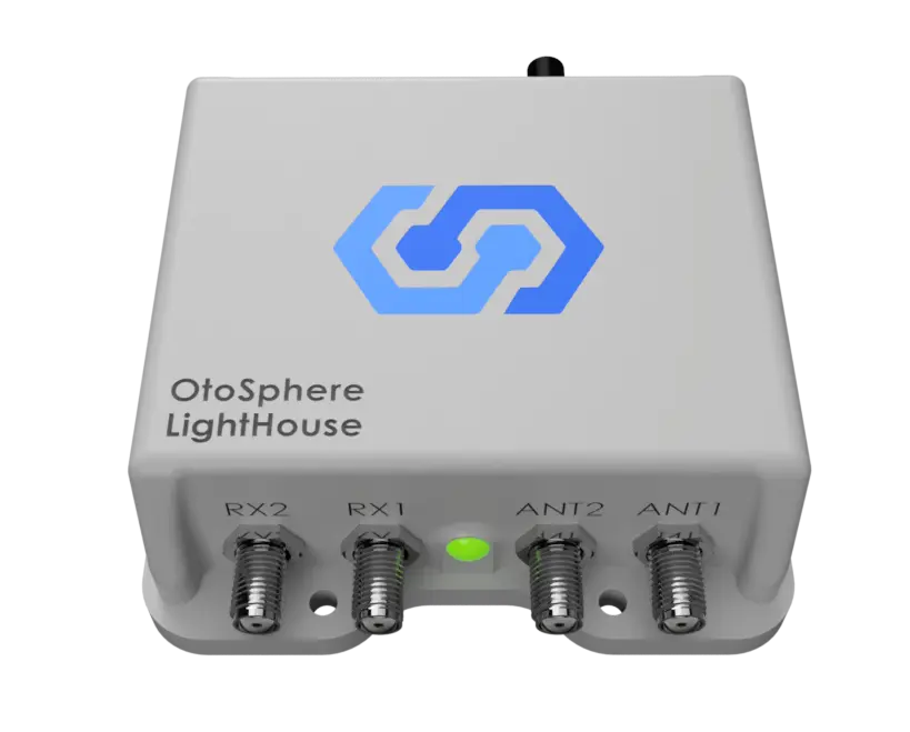
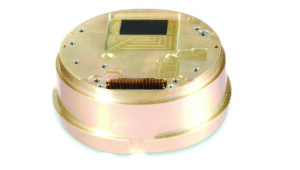
The test recreated a scenario in which criminals deploy in-car GNSS jammers to disable location reporting systems. Two identical tracking units were installed: one protected by OtoSphere-Lighthouse (80×78.5x28mm, 180g), infiniDome’s newest anti-jamming module for commercial use, and one left unprotected.
Credit: InfiniDome
As jamming began inside the vehicle, the unprotected tracker quickly lost GPS signal and failed to transmit location. In contrast, the protected unit maintained full functionality, continuously reporting real-time data throughout the test.
The trial demonstrated the reliability of infiniDome’s technology in commercial environments, the company said. The OtoSphere-LightHouse module was developed to deliver advanced anti-jamming protection for critical applications. As GPS has become essential across industries — from logistics to emergency service — so have the risks.
InfiniDome’s presence at the International Drone Show in Denmark June 18–19, comes at a time when European stakeholders are actively seeking solutions to protect UAVs, maritime, and fleet operations from GNSS disruption — a risk that’s no longer theoretical.
India continues to make significant progress in developing indigenous unmanned aerial vehicles, loitering munitions and autonomous systems. However, many of these platforms face a critical vulnerability: their reliance on unprotected satellite navigation. This threat is no longer theoretical.
Recent escalations with Pakistan, including drone incursions, cyber operations and suspected GPS interference near sensitive border areas, have underscored the growing use of low-cost, easily concealed GNSS jamming tools. Such devices can disrupt UAV operations, sever navigation links and compromise mission success, regardless of how sophisticated the system may be.
Without robust GNSS protection, even the most advanced unmanned systems are at risk of operational failure, loss of control and diminished national security capabilities.
One countermeasure comes from infiniDome, a global provider of GNSS protection technology. The company develops lightweight, easily integrable anti-jamming solutions that are already deployed by leading defense forces to ensure continuous operation in contested electromagnetic environments.
InfiniDome has extensive operational experience in active conflict zones and a strategic focus on compact, cost-effective systems. These solutions are well suited to India’s growing demand for scalable, lightweight UAVs and autonomous platforms, according to the company.
A roundup of recent products in the GNSS and inertial positioning industry from the July 2024 issue of GPS World magazine.
MAPPING
Mobile Mapping System With integrated inertial labs INS/lidar
The Meridian mobile mapping system integrates the Mosaic X camera with Inertial Labs inertial navigation system (INS) and lidar to improve mapping accuracy.
The Meridian system offers panoramas with a 74 MP native resolution and 13.5 K resolution using precisely synchronized camera modules. The design minimizes image overlap to offer clearer and more consistent panoramas. The integrated INS system has a vertical accuracy of 2 cm to 3 cm and a precision of 2 cm to 4 cm.
It features seamless, out-of-the-box operations with fully integrated and calibrated components. The Meridian system is designed for ease of use and requires only minutes of training. In addition, it features a rugged design to ensure performance in challenging environments.
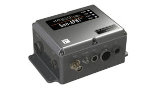
The Geo-APNT serves applications requiring precise navigation data and an accurate time reference. The Geo-APNT combines a versatile GPS master clock with an INS to
offer assured positioning, navigation and timing (PNT) under all circumstances, including temporary loss of GPS signal. It minimizes size, weight and power (SWaP) due to the integration of positioning and timing that are typically achieved by two independent subsystems.
It can be easily integrated into existing systems and supports RTK and PPK positioning and offers support for MEMS, fiber optic gyro and ring laser gyro inertial measurement units (IMUs). The system also includes GPS antenna and cables.
This line of tactical-grade IMUs is engineered to address the evolving needs of unmanned applications and 2 space-based operations.
The IMUs include Iconyx, a high-performance HRG-based IMU that significantly outperforms legacy technologies, the company says. It offers improved accuracy and reliability for demanding navigation needs. It also features a small tactical IMU (STIM) ideal for applications requiring lower size, weight and power (SWaP).
The company is upgrading its Geonyx inertial navigation system (INS), which is based on HRG technology, to incorporate M-Code capability. The fully integrated solution can perform in GPS- denied or spoofing environments, offering reliable navigation in challenging environments.
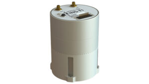
GPS-Aided INS For land, marine and aerial applications
The INS-FI, a GPS-INS, is designed for enhanced performance and reliability across various platforms including land, marine and aerial applications.
The INS-FI is built with tactical-grade fiber optic gyroscope (FOG) technology and an IP67 rating, indicating its robustness and resistance to electromagnetic and environmental interference. This system integrates an IMU that combines fiber optic gyroscopes and MEMS accelerometers, along with an all-constellations GNSS receiver supporting multiple bands.
It offers horizontal and vertical positioning with approximately 0.1% error of distance traveled for land applications and a drift of five nautical miles per hour for aerospace applications without GNSS signal. INS-FI is fully compatible with Inertial Labs’ Air Data Computer (ADC), visual inertial navigation systems (VINS) and a stand-alone magnetic compass (SAMC).
INS-FI incorporates sensor fusion filter technology, navigation and guidance algorithms and calibration software to ensure optimal performance and reliability. The system aims to provide precise horizontal and vertical positions, velocity, and absolute orientation (heading, pitch and roll) for any mounted device, maintaining high accuracy for both stationary and dynamic applications.
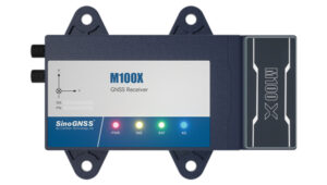
The M100X GNSS receiver is built with the Quantum-III SoC Chip, designed to provide full-constellation and multi-frequency capabilities, specifically engineered for high-accuracy vehicular positioning and heading.
The M100X features GNSS/INS integrated technology to provide real-time high- precision positioning, velocity and heading data, even in challenging environments.
The receiver provides accurate positioning and heading information across various applications, including autonomous mining trucks, intelligent ports, mapping and autonomous buses. It is designed to safeguard vehicles as they pass through areas with poor signal reception, even in obstructed environments such as urban canyons, city overpasses, underground garages, tunnels and parks.
The M100X has a data update rate of up to 100Hz, allowing it to perform well in
very dynamic environments, such as vehicles traveling at high speeds. This rapid update capability enables continuous and real-time tracking of vehicle positions for reliable computation and instant updating of navigation information. It also facilitates quick responses to changes in vehicle dynamics during travel. These features are essential for maintaining seamless operation in high- speed environments and ensuring high levels of safety and performance.
Constructed with aluminum alloy and rated IP67 for water and dust resistance, the receiver is built to withstand harsh operational environments. It also features a shock-resistant design, capable of surviving a drop from 1 m without damage. It can connect to 4G, LAN, Bluetooth and multiple I/O ports for seamless integration with various systems and networks.
The M100X can be used with the Navigation Master software, an Android app for quick device configuration and effective remote management. Using Bluetooth connectivity, users can configure their M100X devices for optimal performance. Additionally, its cloud platform, NaviCloud, offers instant access to projects and data from any location.
Spirent has implemented Xona Space Systems’ PULSAR production signals for seamless integration into the existing SimXona product line. The PULSAR X1 production signal implementation has passed Xona certification and the PULSAR X5 signal verification process is currently underway. It is expected to pass certification during the summer of 2024. Spirent is now accepting orders for SimXona with production signals capability.
Xona is developing PULSAR, a high-performance PNT service built on a backbone of low-Earth orbit (LEO) small satellites. Xona’s smallsat signals will improve PNT resilience and accuracy by augmenting GNSS while operating with an independent navigation and timing system architecture. Xona is fully funded to launch its production class satellite, the In-Orbit Validation mission, in 2025.
Spirent is the leading provider of PNT test solutions and recently launched a sixth-generation simulation system, PNT X. Designed for navigation warfare (NAVWAR) testing, PNT X is an all-in-one solution with native implementation of SimXona.
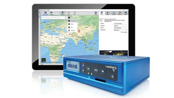
The LabSat 4 GNSS simulator is designed to meet the demands of modern GNSS signal testing. It is equipped with three radio frequency channels, each of which can be configured with up to 12-bit I&Q quantization and a bandwidth of up to 60 MHz. This allows users to precisely control recording parameters and optimize file sizes based on their specific testing requirements. Additionally, synchronized record and replay of external data sources such as CAN, CAN-FD, RS232 and digital event capture are designed to further enhance complex test scenarios.
Users can save custom record settings for efficient setup and repeatability. Additionally, a user-friendly, web-based interface allows for easy configuration and management of the simulation environment.
LabSat 4 offers file management capabilities with 7.6 TB internal storage and robust data transfer options via Gigabit Ethernet and USB 3.0. This technology accommodates the high- volume data needs of modern GNSS testing without sacrificing speed or performance.
It is small, portable and cost-effective, making it suitable for use both in the field and in the laboratory. LabSat 4 is fully compatible with SatGen Simulation Software, which allows users to create GNSS RF I&Q scenario files based on custom trajectories. This integration enables the simulation of scenarios involving multi-stop routes, time zone transitions, leap seconds and more, using any specified time, date and location.
BroadSim Duo is a dual-frequency GNSS simulator designed specifically for testing military receivers in an unclassified environment.
BriadSim Duo integrates dual-frequency capabilities within a single compact GPS military signal testing unit. The simulator has dual-frequency capability, which is essential for testing P-Code and AES-M-Code. It features a new software-defined radio in an M.2 form factor, offering robust and reliable performance. It also seamlessly integrates with the Skydel simulation environment for improved versatility and functionality.
Adtran has released two optical cesium atomic clocks, the OSA 3300 Super High-Performance (OSA 3300 SHP) and the OSA 3350 Super Enhanced Primary Reference Clock+ (OSA 3350 SePRC+). The devices use optical pumping technology to meet evolving demands across applications from scientific research to critical PNT infrastructure.
The OSA 3300 SHP offers stability and accuracy, making it a valuable tool for metrology institutes and scientific research facilities. The OSA 3350 SePRC+ is specifically designed to enhance holdover capabilities for PNT services.
It maintains 100 days of 100-nanosecond precision, providing continuous and accurate timing even in environments where GNSS is compromised or unavailable. This makes it a crucial
component for ensuring the integrity of mission-critical networks and supporting vital infrastructure and defense operations with reliable backup timing.
The Zenith60 Pro GNSS smart antenna is designed for surveyors and construction professionals. It is a real-time kinematics (RTK) rover that features calibrated free tilt compensation to measure otherwise inaccessible points. The antenna is suited for harsh climates, urban areas, dense canopy coverage or other challenging terrains.
This multi-constellation, multi-frequency GNSS receiver features a GNSS board with more than 800 channels and IP68 protection against dust and water. It also connects with GeoMax total stations and X-PAD field software to create an efficient and flexible workflow.
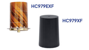
The HC979XF antenna is designed to provide optimal support for the entire GNSS band, including GPS/QZSS L1/L2/L5 (QZSS L6), GLONASS G1/G2/G3, Galileo E1/E5a/b/E6, BeiDou B1/B2a/b/B3, NavIC L5 and L-Band corrections services.
The key new feature of the HC979XF and HC979EXF antennas is the support for Galileo’s Global High Accuracy Service (HAS) and QZSS’s regional Centimeter Level Augmentation Service (CLAS). Both correction services are broadcast in the E6/L6 band (1258- 1300 MHz).
The radio frequency spectrum has become congested worldwide due to the activation of many new LTE bands. Their signals or harmonic frequencies can affect GNSS antennas and receivers.
In North America, the planned Ligado service, which will broadcast in the frequency range of 1526 to 1536 MHz, can affect GNSS antennas that receive space-based L-band correction service signals (1539 – 1559 MHz). New LTE signals in Europe [Band 32 (1452 – 1496 MHz)] and Japan [Bands 11 and 21 (1476 – 1511 MHz)] have also affected GNSS signals. Calian’s XF models are designed to mitigate the effects of these new signals.
The Calian HC979XF housed helical antenna weighs 42 g and is enclosed in a military-grade IP69K plastic enclosure. The embedded HC979EXF helical antenna weighs 8 g. It is easily mounted with an optional embedded helical mounting ring, which traps the outer edge of the antenna circuit board to the host circuit board or any flat surface. An MCX connector is installed in the base of the antenna.
WingtraCLOUD software is designed to simplify data collection and streamline the onboarding of surveyors and pilots.
WingtraCLOUD offers a user-friendly flight planning experience, plus time-saving features including site-based file organization, advanced 3D planning, coordinate system by sites and improved connectivity via cloud syncing in a single environment.
It aims to simplify and streamline site setup and team collaboration. WingtraCLOUD’s features accelerate planning and introduce anew level of transparency among stakeholders with enhanced wireless functionality. Users can now provide insights to regional and global site managers across projects.
WingtraCLOUD allows users to maximize Wingtra aerial data and services, offering UAV program scaling and business advantages across a variety of industries.
FLYC-300 is designed 2 for advanced applications in UAVs, unmanned ground vehicles (UGVs) and autonomous mobile robots. Weighing 297 g, the FLYC-300 features a low size,
weight and power (SWaP) form factor and delivers 100 TOPS AI performance. It supports autonomous navigation, object detection, real-time inference, and SLAM capabilities.
The FLYC-300 is suitable for industries such as inspection, logistics, rescue operations, security, agriculture and environmental monitoring. It supports a variety of sensors and cameras, accommodating RGB, infrared, hyperspectral, HDR and high-resolution cameras. It can seamlessly integrate with flight controllers, vehicles or robots.
The computer can operate with a wide voltage input range from 4S to 14S battery packs or 12 V to 60 V DC input via the XT30 DC-IN connector, making it versatile for different unmanned systems. It also supports 5G or 4G modules for real-time transmission of images, videos and data. The computer is available in two configurations, with or without an enclosure, to meet varying application needs.
The VTOL hangar drone combines the JOUAV JOS-C800 hangar with its new VTOL fixed-wing UAV, CW-15V.
This “drone-in-a-box” solution isdesigned to offer amore efficient and versatile solution for businesses looking to optimize their routine operations through automated aerial technology.
The JOS-C800 hangar system is composed of an automated hangar, a newly developed VTOL fixed-wing drone CW-15V, and the Jocloud management platform. This system enables complete management and monitoring of automated aerial missions through cloud-based remote operations.
Its key features include autonomous takeoff and landing, intelligent flight planning, automatic charging, data management, intelligent data analysis and report generation, enabling fully automated drone operations without the need for on-site personnel.
The JOS-C800 uses AI and AR algorithm integration to classify and identify potential hazards in the collected data, supporting the display and management of these hazards on Jocloud, and generating detailed hazard classification reports. The upgraded algorithms allow for real-time stitching and comparison of video data comparative analysis to identify new or changed hazards.
It supports multi-UAV, multi-hangar operations with staggered takeoffs, allowing for hop-and-fly operations. The CW-15V UAVs can be paired with various payloads such as gimbal cameras, lidar and oblique cameras.
INVOLI, a specialist in cooperative air traffic surveillance solutions, has partnered with MatrixSpace to create a comprehensive air traffic awareness solution through a unified platform.
The partnership combines INVOLI’s cooperative detection technology with MatrixSpace’s advanced non-cooperative detection capabilities, facilitated by miniaturized primary radar technology. This integration allows for complete surveillance of both airborne and ground-based traffic, significantly enhancing UAV detection, counter unmanned aircraft system (CUAS) capabilities and safety for beyond visual line of sight (BVLOS) operations.
The integrated solution is designed to be low in size, weight, power and cost (SWaP-C), and can be deployed quickly without the need for additional infrastructure or specialist training. This makes it suitable for a variety of applications, including surveillance of sensitive sites such as prisons and energy infrastructure, as well as supporting safe and efficient BVLOS UAV operations.
NavStorm-M is a gun-hardened integrated anti-jamming GPS receiver for artillery, bombs, missiles and unmanned systems.
It features a layered protection approach using beamforming, anti-spoofing, resiliency and software assurance. It is an assured positioning, navigation and timing (A-PNT) device featuring M-Code GPS technology. It offers GNSS protection of two bands (L1/E1+L2 or L1 + G1 or L1/E1 + L5) from up to three directions of jamming simultaneously.
NavStorm-M is designed to meet the tight size, weight, power and cost (SWaP-C) requirements of unmanned aircraft systems, loitering munitions, hypersonic platforms and other weapons — especially in gun-hardened applications. NavStorm-M offers precise GPS navigation as a stand-alone system or integrated with an INS.
GPSdome2 is a high-end anti-jamming and fully retrofit solution tailored for defending manned and unmanned ground vehicles and UAVs from jamming attacks. It can be integrated with various GNSS off-the-shelf receivers. Using up to four off-the-shelf active antennas, with dual-band protection — GPS L1+L2 or GPS L1+Glonass G1 — it protects from up to three jamming directions simultaneously in each band. With optional mil-spec compliance, it can serve smaller and lighter platforms.
Atlas is a Group II loitering munition with robust capabilities in air, land and sea tactical scenarios. With a flight duration of more than two hours and a striking distance comparable to larger Group III aircraft, Atlas delivers mission flexibility and performance.
Designed for high-impact scenarios, it supports a range of operations such as intelligence, surveillance, and reconnaissance (ISR)/detect, identify, locate and report (DILR), electronic warfare and direct-action engagements. The munition’s payload includes options for fragmentation or penetration effects, further enhanced by optional ISR capabilities.
Zoe M4 is a portable and foldable quadcopter platform designed to rapidly deploy an overwatch capability for military personnel and units. It is easy to transport and set up, making it ideal for security, ISR (intelligence, surveillance, and reconnaissance), and emergency response applications.
It is equipped with the NextVision Raptor X80, a military-grade EO/IR gimbal that offers stabilized daytime and night-time imagery with 80x zoom and thermal imaging in high resolution. The NDAA-compliant quadcopter features the same rugged capabilities as the base Acecore Zoe model, including a robust carbon fiber construction, an all-weather waterproof design and the ability to survive winds of up to 29 knots.
The Zoe M4 is paired with Acecore’s Signav Ultra ground control station (GCS), a lightweight handheld device based upon the Panasonic FZ-M1 tablet and rated to MIL-STD-810G. It can be factory-configured for compatibility with existing military networks or frequency bands between 1625 to 2510 MHz.
infiniDome, a provider of GPS protection and resilient navigation solutions, has opened infiniDome USA, a new subsidiary designed to enhance service to the United States defense industry.
By establishing infiniDome USA, infiniDome aims to strengthen its relationships with U.S. customers, offering more localized support and ensuring that its innovative GPS protection technologies meet the specific needs and challenges faced by American aerospace and defense sectors.
infiniDome’s anti-jamming technology offers resilience and reliability to critical systems across a variety of sectors including defense, timing systems, aviation, and autonomous vehicles.
According to the company, infiniDome’s expansion to the U.S. comes in response to the critical need for enhanced proportional GPS security measures amidst the growing threats to GPS-dependent technologies. In direct correlation to government and industry projects, calling for small, light, “attritable” UAVs, protection for such platforms also must be proportional in size, weight, and cost.
infiniDome invites industry partners, customers, and media to learn more about infiniDome USA and its advanced GPS protection and navigation resiliency solutions at AUVSI Xponential 2024 in San Diego, which takes place April 22 to 25.
Electronic warfare in the Middle East and Ukraine is affecting air travel far beyond the battlefields, unnerving pilots and revealing unintended consequences of a tactic that experts believe will become more widespread, reportedThe New York Times.
Planes are losing satellite signals, flights have been diverted and pilots have received false location reports or inaccurate warnings that they were flying close to terrain, according to European Union safety regulators and an internal airline memo viewed by The New York Times. The Federal Aviation Administration (FAA) has also warned pilots about GPS jamming in the Middle East.
Following Russia’s invasion of Ukraine in early 2022, radio frequency interference only continues to increase across the Middle East as of autumn 2023. These interferences can involve jamming GNSS signals to obstruct or block them using noise, or mimicking signals to trick GNSS receivers into picking up counterfeit satellite signals, known as spoofing.
Aircraft systems have been unable to detect GPS spoofing and ultimately correct for it. According to Opsgroup, an organization that monitors changes and risks in the aviation industry, one Embraer jet bound for Dubai nearly veered into Iranian airspace in September before the pilots figured out the plane was chasing a false signal.
“We only realized there was an issue because the autopilot started turning to the left and right, so it was obvious that something was wrong,” crew members reported to Opsgroup.
Issues arise
With the rise of electronic warfare, the strain on aviation could be a sign of more serious economic and security issues.
The U.S. government calls GNSS signals “an invisible utility.” Smartphones, cars, stock exchanges, data centers and countless industries rely on them for time, navigation or both. Similar systems exist around the world, such as Galileo in Europe, Glonass in Russia, QZSS in Japan, NavIC in India and BeiDou in China. One study from Britain said a five-day disruption of satellite signals could cost the country $6.3 billion.
Minor interference with GPS signals is fairly common. GPS jamming devices, while illegal to use, are inexpensive and easy to obtain from vendors on the internet. Governments, too, have been more willing to overtly interfere with signals as a tactic in electronic warfare.
It is not always possible to distinguish jamming from spoofing, or to determine who is behind the interference. Israel said in mid-October it had restricted GPS in the region and had warned pilots not to rely on satellite navigation systems for landing.
Russian interference is well-documented. A 2019 report by the Washington-based analytical nonprofit group C4ADS showed extensive spoofing from a Russian-controlled air base in Syria. Reports also indicated that, when Russian President, Vladimir Putin, traveled to remote locations or Russian-occupied Crimea, he was flanked by mobile GPS-spoofing technology.
Jamming is common in conflict zones. Spoofing, until recently, was considered rare.
The interference has been felt up to 190 miles away from battlefields and “appears to go well beyond simple military mission effectiveness,” according to Eurocontrol, Europe’s primary air-traffic-control manager. The worst-affected regions include the aerial space above the Black Sea area from Turkey to Azerbaijan; the Mediterranean Sea extending from Cyprus to Libya; the Baltic Sea near Poland and Latvia; and the Arctic near Finland and Norway.
Airbus said it recorded nearly 50,000 interference events on its aircraft last year, more than four times as many as the year before. This came on top of an over twentyfold jump in radio-interference events from 2017 to 2018, as recorded by a voluntary incident reporting system run by Eurocontrol. Eurocontrol said the increased jamming since 2018 was most likely meant to interfere with battlefield UAVs.
In the Middle East, there have been reports of false signals telling pilots their aircraft were directly above the airport in Tel Aviv despite being far away. Opsgroup said it had received around 50 similar reports. In some cases, onboard equipment showed that planes were approaching airports in Baghdad, Cairo or Beirut, Lebanon, when they were not.
Looking ahead
Spoofing is hard to distinguish because the signal appears legitimate. Only Europe’s Galileo incorporates an authentication system that can verify when a signal is from its satellites. Galileo, which currently is the most accurate and precise navigation satellite system, plans to introduce an even stronger level of authentication, according to the European Commission.
But even Galileo’s authentication cannot protect against one of the most dreaded types of spoofing, known as “meaconing.” In a meaconing attack, a spoofer would record satellite signals, and then rebroadcast them with an amplification or a delay. Experts have not publicly confirmed any meaconing attacks in the Middle East.
Opsgroup said the latest events should prompt manufacturers to re-examine the integration of satellite signals in aircraft electronics, known as avionics, without a safeguard that can identify false signals.
In this environment of intentional GPS jamming and spoofing, Israel has produced a leading anti-jam technology company, InfiniDome, located in Caesarea. According to co-founder Omer Sharar, the company has been working to defend GPS signals for more than seven years and has also seen the rise of devices to jam the GPS L1 frequency that anyone can buy online for $100.
Most readily available jammer electronics only output interference disrupting GPS L1, which is commonly installed for vehicle tracking and UAV guidance. InfiniDome says it has successfully protected trucking, UAV operations and others in Israel and around the world with its Infinidome GPSdome-1 and GPSdome-2 anti-jam products.
It is clear the conflict’s repercussions extend well beyond the battlefield, highlighting the critical need for security assessments or alternative PNT systems to protect civilians. While there is going to be a significant impact on commercial airline travel to and from Israel while hostilities continue, there is hope for a possible long-term solution for the intense jamming that has plagued the region for years.
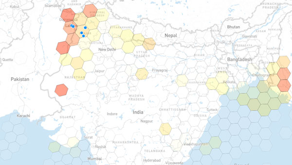
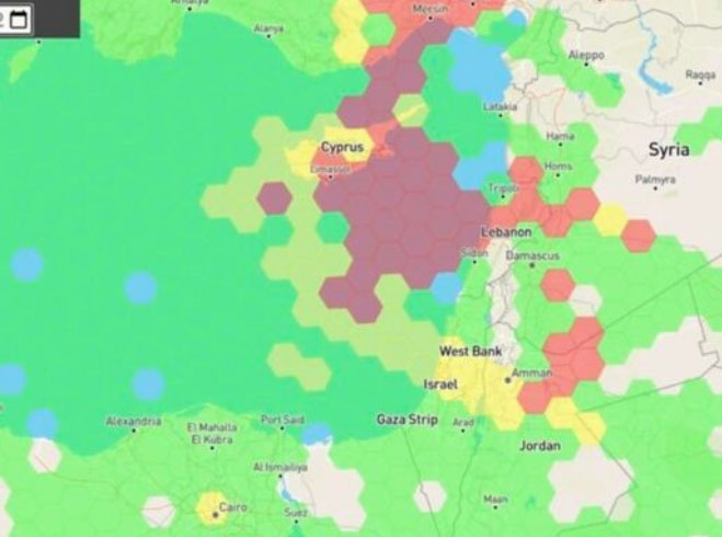
Just as I was beginning to write this article, war broke out between Israel and terrorist forces in Gaza. It would seem that the rockets used by Gaza were aimed rather than carrying on-board guidance, while Israeli airforce bomb/rocket attacks have been carried out with some degree of precision. Nevertheless, jamming in Israel may still be relevant to the ongoing conflict and any on-going commercial aircraft activity. However, it seems from the diagram of jamming below, that the Gaza strip is virtually interference free.
One of the things you can be sure of in the Ukraine-Russia war is that one side or the other is jamming the other’s communications and sat-nav guidance systems. An apparent consequence is that there is likely some “spill-over” to adjacent areas. For Israel, however, it looks like it’s more directed jamming rather than incidental.
Israel GPS jamming. (Image: GPS Jam.org)
In this environment of intentional GPS jamming, it’s not surprising that Israel has produced a leading anti-jam technology company, called InfiniDome, in Caesarea (between Haifa and Tel-Aviv). According to co-founder Omer Sharar, the company has been working to defend GPS signals for more than seven years and has also seen the rise of devices to jam the GPS L1 frequency that anyone can buy online for $100.
Just as Ukraine is throwing explosive cardboard UAVs with little cost at Russian occupying forces, a few carefully placed low-cost jammers could inflict serious damage on a country’s navigation capabilities.
However, a 2019 presentation by Todd Humphreys identified the source of interference and spoofing at that time, a Russian high-power jammer located at a Russian base in Syria.
Humphreys used instrumentation on the International Space Station (ISS) to gather data on the directed interference but concluded that the jamming in Israel could be a consequence of Russia’s efforts to protect its troops in Syria from UAV attacks. The Russian Khmeimim Air Base is on the Mediterranean coast and attacks are thought to come from rebels within Syria.
With the current GPS jamming out of Syria, most commercial aircraft traffic flying into Ben Gurion International Airport is significantly affected as flights cross from over the coast from the Mediterranean. Longer flight tracks deeper southeast into Israel are necessary, probably relying on VOR and DME ground station waypoints before turning back northwest to capture the instrument landing system (ILS) into the airport. This costs time and fuel and causes aircraft to overfly settlements where noise can be a real problem.
Most readily available jammer electronics only output interference disrupting GPS L1, which is most commonly installed for vehicle tracking and UAV guidance. InfiniDome has successfully protected trucking, UAV operations and others in Israel and around the world with its Infinidome GPSdome-1 and GPSdome-2 anti-jam products.
Two antennas 10 cm to 25 cm apart enable GPSDome-1 algorithms to detect and null out a GPS L1 jammer. GPSDome-2 accommodates up to four antennas and can null up to three directional signals on both GPS L1 and L2 or GPS L1 and GLONASS L1.
InfiniDome is currently working with an aerospace company to integrate its anti-jam technology with airborne inertial/GPS and qualify the integrated system for use in civil aviation, with the objective of maintaining max 3% drift when fully jammed. This will introduce certified anti-jam technology into civil aviation use — something that will provide some jamming protection, which airlines desperately need going forward. In addition, other high-end UAV manufacturers are potential customers for this new system.
While the ongoing conflict and the devastating loss of life is forefront as each day of the war passes, these anti-jam solutions may ultimately help solve signal degradation problems. While there is going to be a significant impact on commercial airline travel to and from Israel while hostilities continue, we can maybe see the way to a possible long-term solution for the intense jamming from which the region has suffered for many years.
AUVSI XPONENTIAL 2023 has officially concluded. GPS World had the opportunity to visit several booths during the conference and attend a variety of educational sessions while in the heart of beautiful, downtown Denver.
“Protecting the Homeland: The future of C-UAS” was presented by industry leaders and highlighted capabilities available for detecting, intercepting, and mitigating UAS encroaching or threatening covered facilities, critical infrastructure, and other high-value targets in the National Airspace System.
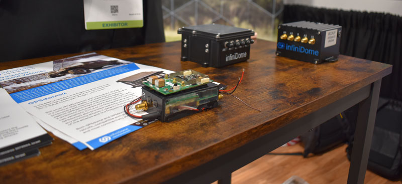
GPS World stopped by infiniDome to hear more about its solutions, including GPSdome.
“Autonomous Exploration and Mapping of Unknown Environments with UAS” dove into the development of simultaneous localization and mapping, world modeling and exploration-based planning algorithms. This session was led by Eric Thorn, manager in the Intelligent Systems Division at Southwest Research Institute.
Honeywell shared the ground station that it is developing.
While CGConnect has already been launched overseas by Advanced Navigation, its first debut in the United States was at XPONENTIAL.
The Association for Uncrewed Vehicle Systems International (AUVSI) has named the winners of the sixth annual AUVSI XCELLENCE Awards.
The awards recognize the accomplishments of companies, organizations and individuals across the uncrewed systems community. The winners were recognized during an awards ceremony at XPONENTIAL 2023 which is being held this week at the Colorado Convention Center in Denver, Colorado. This year’s 50th anniversary event is co-hosted by Messe Düsseldorf North America.
AUVSI’s XCELLENCE Awards honor innovators with a demonstrated commitment to advancing autonomy, leading and promoting safe adoption of uncrewed systems and developing programs that use these technologies to save lives and improve the human condition.
These are the finalists in those categories:
XCELLENCE in Academic Research
First Place: University of Colorado Boulder, 20 Years of UAS Research XCELLENCE
Second Place: Virginia Tech’s Mid-Atlantic Aviation Partnership, Robert Briggs
Third Place: Ocean Alliance, Tagging Whales with Drones
XCELLENCE in Innovation
First Place: Skydio, Skydio Dock, Automated Inspections of Sites with Autonomous, Remote Drone Operations
Second Place: Plus, PlusDrive, An Industry-defining Driver-in, Highly Automated Driving (HAD) Solution
Third Place: Sentera, Eliminating Stitching with the Sentera DGR System
XCELLENCE IN OPERATIONS – Enterprise Application
Advanced Navigation’s Cloud Ground Control featured at XPONENTIAL 2023.
First Place: JobsOhio and the Ohio Department of Transportation, Propelling AAM in Ohio
Second Place: Advanced Navigation, Cloud Ground Control
Third Place: City of Pendleton, Pendleton UAS Range
XCELLENCE IN TECHNOLOGY
Enabling Components & Peripherals
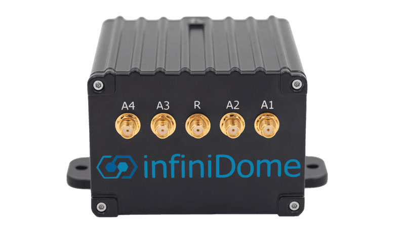
First Place: infiniDome, infiniDome’s GPSdome2
Second Place: Elsight, Elsight Halo
Third Place: MatrixSpace, MatrixSpace Networked Radar
Hardware & Systems Design
First Place: D-Fend Solutions, EnforceAir
Second Place: Advanced Navigation, Hydrus
Third Place: Connect Tech, Anvil Embedded System with NVIDIA Jetson AGX Orin
Software Design and Coding
First Place: BlueSpace.ai, Scalable and Explainable AI for Autonomy, powered by 4D Predictive Perception
Second Place: Skydio, Skydio Scout, Situational Awareness for Moving Convoys
Third Place: AlarisPro, Inc., AlarisPro Safety Ecosystem (ASE) – Advancing UAS Reliability Through Shared Data Across UAS Operators and Manufacturers
The infiniDome booth at XPONENTIAL 2023 showcased their XCELLENCE award.
XCELLENCE in Workforce Development
First Place: Laurel Ridge Community College, Laurels Take Flight
Second Place: DroneUp, with partner, Richard Bland College, Established the First Commercial Drone Workforce Training Program for College Credit
Third Place: Embry-Riddle Aeronautical University Worldwide and Warren College, Better Together: Producing Effective Educational Opportunities for the UAS Workforce
The recipients of the 2023 AUVSI XCELLENCE Humanitarian and Public Safety Awards have established themselves as leaders in the application of uncrewed technology to provide solutions to the world’s most pressing problems. Each awards category recognizes organizations that have made a significant impact using uncrewed systems to serve in humanitarian or public safety efforts. The six organizations will equally divide a $6,000 prize for their humanitarian and public safety efforts.
This year’s recipients are:
XCELLENCE in Mission
Humanitarian Project/Program
First Place: ArroTech, Dr. Stephen Dunnivant
First Place: MissionGO, Inc., Operation Healing Eagle Feather
First Place: The David McAntony Gibson Foundation (GlobalMedic), GlobalMedic RescUAV Response to La Soufrière Volcano in Saint Vincent and the Grenadines
Public Safety
First Place: DRONERESPONDERS, DRONERESPONDERS Public Safety Alliance
First Place: Texas Department of Public Safety, Texas Department of Public Safety
First Place: United States Forest Service, Testing and Scaling New Technologies for Operations and Safer Mixed Airspace Ops
A roundup of recent products in the GNSS and inertial positioning industry from the March 2023 issue of GPS World magazine.
UAV
Image: InfiniDome
Anti-Jamming Device Provides protection from three directions of attack
The GPSdome 2 is tailored to defend small- to medium-sized tactical UAVs as well as manned and unmanned ground vehicles. With a small form factor (500 g, 87 mm x 91 mm x 61.55 mm) and minimal power consumption, GPSdome 2 is suitable for loitering munitions as well as UAVs. Fully retrofit and completely standalone, the system is compatible with almost any off-the-shelf GNSS receiver as well as standard active GNSS antennas, meaning that it can be integrated into existing GPS systems or into new product lines, manned or unmanned. With sophisticated algorithms and a proprietary RFIC, GPSdome 2 analyzes RF interference in the environment and combines multiple antenna patterns to create and dynamically steer three nulls in the direction of any hostile signal. GPSdome 2 provides simultaneous dual-frequency protection (GPS L1 + L2 or GPS L1 + GLONASS G1), creating up to three nulls, protecting from three jamming directions within each band in real time, making it suitable for PNT applications. The GPSdome 2 is a dual-use, non-ITAR device and comes with optional mil-spec compliance. InfiniDome, infinidome.com
Image: uAvionix
Command and Control Designed for easy integration
The SkyLine C2 management platform and muLTElink airborne radio systems (ARS) are designed to integrate, which enables a self-healing command-and-control network capable of both path and link diversity. This eliminates lost-link possibilities over broad terrain and altitude ranges. MuLTElink ARS consists of two models — muLTElink915 and muLTElink5060, the core of the uAvionix C2 system. The muLTElink915 model combines globally licensed aviation LTE, enhanced with frequency hopping 902 MHz – 928 MHz industrial, scientific and medical frequencies capability. The muLTElink5060 model combines global LTE with aviation-protected 5,030 MHz – 5,091 MHz C-band. Each muLTElink model allows up to one external CNPC radio to be optionally connected to allow simultaneous use of all three frequency ranges, higher power C-band operation or future radio integrations. uAvionix, uAvionix.com
Image: Atmos
VTOL UAV With Sony a7R mark III and IV camera
Atmos has integrated the Sony a7R mark III and IV cameras into its vertical take-off and landing (VTOL) fixed-wing UAV, the Marlyn Cobalt. This will increase coverage and accuracy achieved in a single flight for surveyors. Both cameras have an ISO of 32,000, which is expandable to 102,400, and camera sensors with high megapixel count — 42,4 MP for the a7R III and 61 MP for the a7R IV. When combined with Zeiss’ 35 mm and 21 mm lenses, it enables UAV surveyors to achieve ground sample distance levels below one 1 cm. The integration of the two cameras enables Marlyn Cobalt users to map an area of 210 ha with centimeter-level accuracy in a single flight. Atmos, atmosuav.com
Trueview 720. (Image: GeoCue)
TrueView 535. (Image: GeoCue)
Accuracy Star. (Image: GeoCue)
UAV and Lidar Systems Suitable for geospatial professionals
TrueView 535 consists of updated lidar sensors, adding a third return, increasing mapping abilities below canopy. An additional third nadir camera offers another point of view and improves photogrammetry quality. It also includes a longer, usable lidar range to increase flexibility. TrueView 720 is a fourth-generation Riegl VUX-120 with three laser beam orientations. It provides high-point density corridor mapping. Using the Riegl VUX-120 with three laser beam orientations (nadir, +10 degrees forward and –10 degrees backward) and three oblique/nadir cameras enables data collection from more surfaces in one flight path. One application of TrueView 720 is scanning power lines. Users can capture the poles vertically, front and back. The extreme range of this system means it can be integrated with UAVs, airplanes or helicopters. In addition to the two sensor payloads, GeoCue has launched its LP360 software add-on for processing and visualization — the 3D Accuracy and the Accuracy Star hardware.
GeoCue, geocue.com
OEM
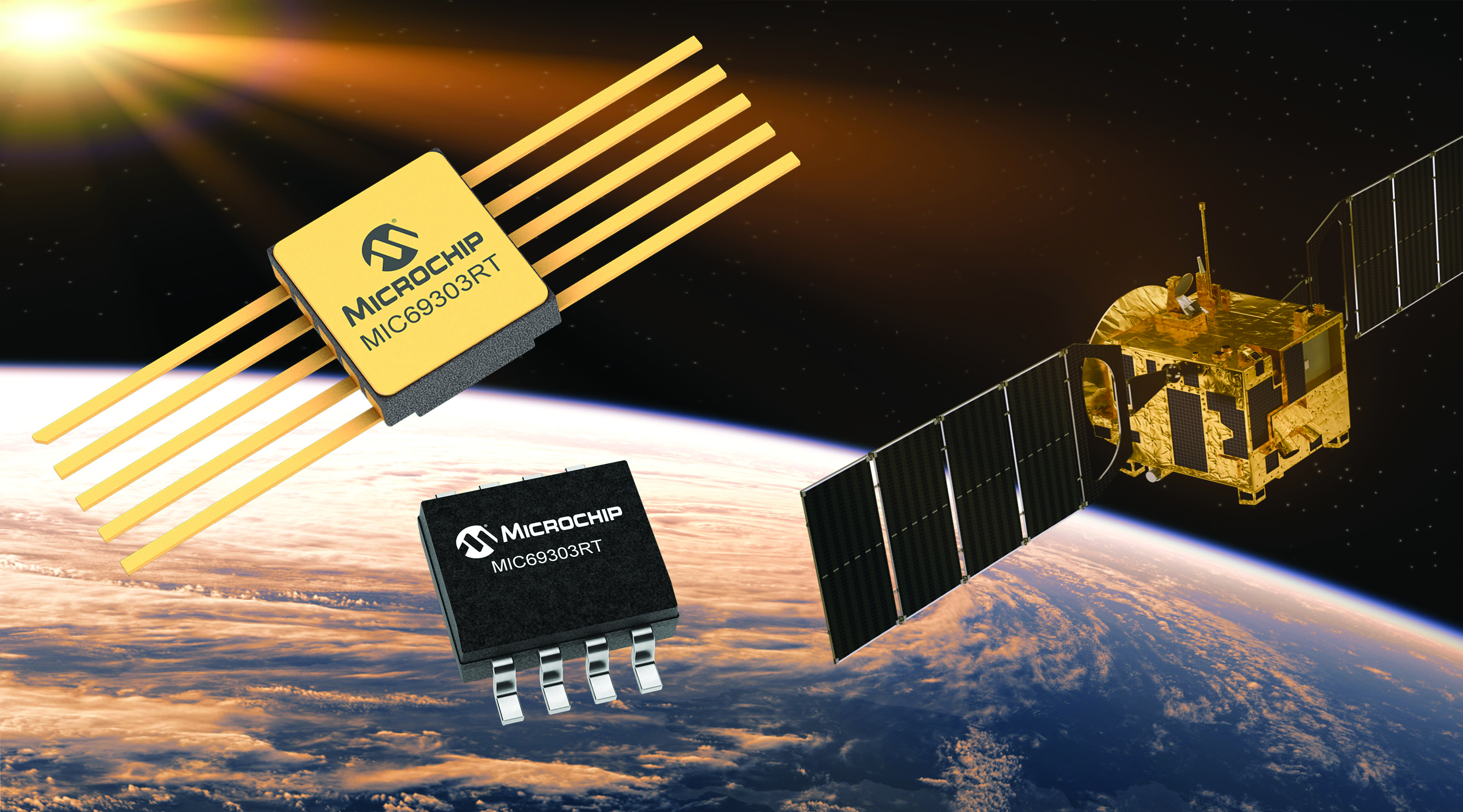
Image: Microchip
Voltage Regulator Device for LEO space application
The MIC69303RT is a radiation-tolerant power management device for space application developers. It is a high-current, low-voltage device targeting low-Earth orbit space applications. The MIC69303RT operates from a single low-voltage supply of 1.65 v to 5.5 v and can supply output voltages as low as 0.5 v at high currents. It offers high-precision and low dropout voltages of 500 mv under extreme conditions. The MIC69303RT is a companion power source solution for microcontrollers, such as the SAM71Q21RT and PolarFire field-programmable gate arrays. MIC69303RT is designed for harsh aerospace applications and remains operational in temperature ranges from -55 C to +125 C. Microchip Technology, microchip.com
Image: Spirent Communications
LEO Satellite Device Designed for GNSS/PNT lab testing
SimORBIT is a low-Earth-orbit (LEO) satellite solution software designed to aid developers in determining LEO orbits more accurately for GNSS/PNT lab testing. The software replicates LEO orbits so that simulations can provide the realistic environment of a LEO satellite, including gravitational and atmospheric impacts the satellite could encounter in space. Developers can create non-ICD signals via I/Q injection, or by the “Flex” feature, generating space-centered PNT signals to be developed in the lab as realistically as possible. Spirent Communications developed SimORBIT in partnership with SpacePNT. Spirent Communications, spirent.com
Image: Sony
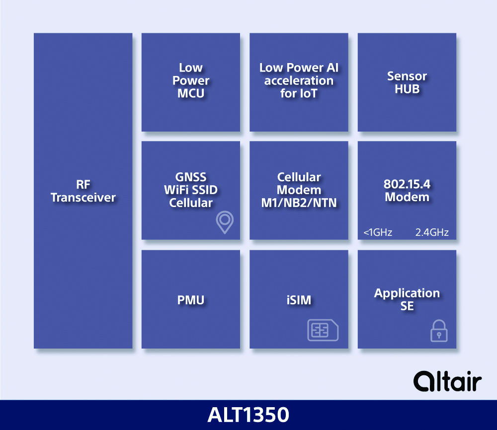
5G Chipset Includes GNSS
The ALT1350 implements GNSS, cellular and Wi-Fi-based location in a single chipset. The cellular LTE-M/NB-IoT chipset is designed to enable additional low-power, wide-area (LPWA) communication protocols; intermittent LTE and GNSS (GPS/GLONASS) navigation for low-cost applications; and concurrent LTE and L1/L5 GNSS for tracking applications. The ALT1350 incorporates a sensor hub to collect data from the sensors while maintaining ultra-low power consumption. It also provides cellular and Wi-Fi-based positioning and is tightly integrated to provide power-optimized concurrent LTE and GNSS to accommodate various tracking applications, which can be demanding with a single chip. The chip is designed to enable deployments for the internet of things (IoT), including location technologies. Sony, altair.sony-semicon.com
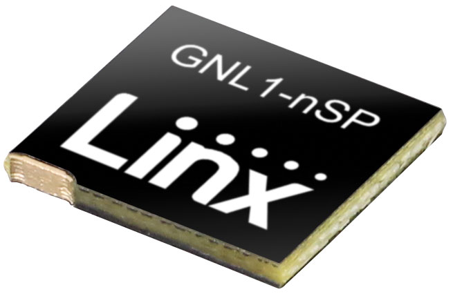
The ANT-GNL1-nSP is a surface-mount embedded GNSS antenna supporting GPS, Galileo, GLONASS, BeiDou and QZSS in the L1/E1/B1 bands. The ANT-GNL1-nSP antenna exhibits high performance in a compact size (10 mm x 8 mm x 1 mm) and features linear polarization and an omnidirectional radiation pattern. The antenna is available in tape and reel packaging and is designed for reflow-solder mounting directly to a printed circuit board for high-volume applications. Linx Technologies, linxtechnologies.com
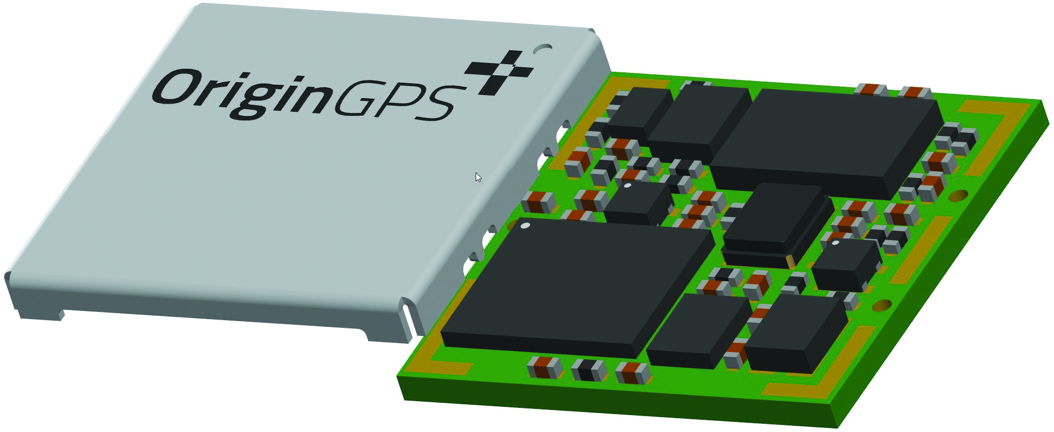
Image: OriginGPS
GNSS Module Based on a MediaTek chipset
The ORG4600-MK01 dual-frequency module provides higher precision than the company’s previous modules. It has sub-1 m precision at a cost lower than that of the company’s first L1+L5 module, the ORG4600-B01, which is based on Broadcom’s chipset. The 10 mm x 10 mm ORG4600-MK01 was designed for applications deployed in challenging environmental conditions. The solution also includes RTCM, a logger and accurate orbit prediction. OriginGPS, origingps.com
MAPPING
Image: Mapbox
Navigation Software Includes enhancements to existing software and more
Navigation software development kit version 2.9 provides pre-built applications compatible with Android and IOS. SDK v2.9 provides the primary navigation components across a workflow using lines of code instead of starting from square one. The drop-in user interface is customizable to reflect a developer’s brand, obviating the need to manually develop a full end-to-end application. Navigation SDK Copilot — a backend analytics tool for CX on navigation applications — collects trace files of navigation sessions and search analytics data from users. Developers can use this data to gather feedback and collective user data to create touch points with users and improve application experience based on their data-drawn conclusions. Matrix API has been updated to support scheduled departure times and provide optimal driving routes, creating a more accurate estimated time of arrival. Mapbox, mapbox.com
Image: Hexagon
Defense Platform For developing Android applications
LuciadCPillar is designed for the development of mobile applications for dismounted soldiers in the field. Developers can build applications with 2D and 3D views. It features military symbology and supports many geospatial data types including vector data, raster data, elevation data, point clouds and 3D meshes. It has the same capabilities found in desktops, in-vehicle and browser applications built with LuciadLightspeed, LuciadCPillar and LuciadRIA. The platform offers capabilities to match high-resolution screens, graphic processing units and multi-core processors including the ability to display 3D data in mobile applications. LuciadCPillar supports ARM processors and an application programming interface, which aligns with the Android developer experience. Impact, a French system integrator, partnered with Hexagon to test LuciadCPillar and will integrate it into its Delta Suite product, which is used by the French Special Operations Command. LuciadCPillar is part of Luciad 2022.1, which is available now globally. Hexagon, hexagon.com
Image: Golden Software
Surface Mapping Designed for 3D surface mapping
The Surfer package is designed for 3D surface mapping and provides robust subsurface visualization and modeling functionality by incorporating many true 3D gridding and visualization tools. With the enhanced functionality, users can now model an additional variable, a C variable, such as a contaminant or chemical concentration, along with the traditional X, Y, Z values. Surfer also includes the ability to create a 2D map of a slice-through 3D grid, which users can move up and down through the grid, illustrating how the C value changes with depth. Part of Surfer’s enhancements is isosurface creation, enabling visualization of the 3D grid in the 3D view as an isosurface, providing another way to see how C data varies with depth or elevation. The new 3D-rendered volume functionality also allows users to visualize the 3D grid in the 3D view as a solid body by assigning colors to different C values, highlighting variations in the data. Golden Software, goldensoftware.com