Anthony Gage from Canon Solutions America details the Océ ColorWave 650 at the 2015 Esri Federal GIS Conference, held Feb. 9-10 in Washington, D.C. The machine can print up to 1,300 square feet per hour in both black and white and color. It can hold up to six media rolls, and prints come out dry and cut to size.
Tag: mapping
-
Lehmann Rolls Out OpsCenter Upgrade, Drops Drone Price

The Lehmann L-A 300 drone is designed for mapping. Lehmann Aviation has rolled out a new version of its OperationCenter, a flight preparation and mission control software program for automatic orthomosaic flights. Also, the company dropped the price for its L-A 300 fully automatic professional drone designed for mapping, because of an uptick in demand and increased production.
The new version of Lehmann OpsCenter, designed for Windows 8.1 tablets and PCs, now includes:
- New mission control functions (holding, auto return, non-flying zone)
- Terrain awareness during mission preparation, for safer flights in mountain areas
- Integration with Google Earth for flight preparation and replay
- New easier upgrade and update procedures directly through the web
- New options to manage new cameras (GoPro, Canon) for orthomosaics and surveying.
Priced at $2,890, the L-A 300 is a professional drone designed for accurate mapping and digital elevation models (DEMs) that works with the GoPro, Canon S110 and multispectral cameras. It flies automatically for 30 to 45 minutes at a trajectory pre-prepared by the user in the OpsCenter (the range is 18.5 miles).
“In 2014 we significantly increased our production volume thanks to numerous orders from all around the world,” said Benjamin Lehmann, founder and CEO of Lehmann Aviation. “This enabled us to reduce the price for our best-sellers, all L-A-series drones. We also made the decision to follow our strategy of offering really high-tech aerial solutions at fair prices.”
-
FAA Grants Two More UAV Exemptions
The eBee Sensefly UAV. Photo: Advanced Aviation Solutions The Federal Aviation Administration (FAA) today granted two more regulatory exemptions for unmanned aircraft systems (UAS) operations for commercial use.
The FAA granted five exemptions to four companies in December.
The two companies are Advanced Aviation Solutions of Spokane, Wash., and Tierra Antiqua Reality of Tuscon, Ariz. Advanced Aviation Solutions plans to fly an eBee senseFly UAV Ag system carrying a georeferenced still camera to conduct photogrammetry and crop scouting in order to perform precision agriculture.
The eBee Ag system consists of a 1.5-pound battery-powered aircraft, a personal computer-based ground control station, and associated communications equipment. The UAV is a fixed-wing aircraft with a wingspan of about 3 feet and 2 feet in overall length, which can operate at a maximum speed of about 50 knots.
Tierra Antiqua Reality plans to operate a Phantom 2 Vision+ UAS, which is comprised of an unmanned aircraft and a transportable ground station. The company plans to attach a small ultra-6 lightweight GoPro 3+ camera to the Phantom and operate it over various areas near Tucson to enhance academic community awareness and augment real estate listing videos.
The Phantom is a 3-pound quadcopter with a maximum airspeed of 30 knots.

The Phantom 2 Vision quadcopter. Photo: Phantom -

FAA Grants UAS Exemption to Trimble Navigation

The Trimble UX5. Photo: Trimble The Federal Aviation Administration (FAA) today granted five regulatory exemptions for unmanned aircraft systems (UAS) operations to four companies representing several industries that promise to benefit from UAS technology, including Trimble Navigation Ltd.
The four companies that received exemptions want to fly UAS to perform operations for aerial surveying, construction site monitoring and oil rig flare stack inspections.
“Unmanned aircraft offer a tremendous opportunity to spur innovation and economic activity by enabling many businesses to develop better products and services for their customers and the American public,” Transportation Secretary Anthony Foxx said. “We want to foster commercial uses of this exciting technology while taking a responsible approach to the safety of America’s airspace.”
The commercial entities that received exemptions today are Trimble Navigation, VDOS Global, Clayco, and Woolpert (two exemptions). The FAA earlier granted exemptions to seven film and video production companies. This is the first exemption granted to a leading GNSS firm.
Secretary Foxx found that the UAS in the proposed operations do not need an FAA-issued certificate of airworthiness because they do not pose a threat to national airspace users or national security. Those findings are permitted under Section 333 of the FAA Modernization and Reform Act of 2012.
The firms also asked the FAA to grant exemptions from regulations that address general flight rules, pilot certificate requirements, manuals, maintenance and equipment mandates. In their petitions, the firms said they will operate UAS weighing less than 55 pounds and keep the UAS within line of sight at all times.
The exemption will allow Trimble to conduct commercial operation of its UX5 Aerial Imaging Solution. The UX5 is an unmanned fixed-wing aircraft targeted at the surveying, agriculture, oil and gas, mining, construction, environmental industries. The system autonomously captures a series of high-resolution images during flight, which is typically up to 50 minutes covering as much as 2.3 square kilometers (approximately 1 square mile) when flying 120 meters (approximately 400 feet) above the ground. Using Trimble Business Center Aerial Photogrammetry software, images are used to easily generate 2D and 3D deliverables such as orthomosaic images, three-dimensional point clouds and contour maps. The Trimble UX5 enables the collection of large amounts of data, often faster than traditional surveying or mapping technologies.
The Trimble UX5 surveys a construction site. Photo: Trimble “We are pleased to be among the first companies to receive an exemption from the FAA authorizing commercial operation of UAS,” said Erik Arvesen, vice president of Trimble’s Geospatial Division. “This decision reflects Trimble’s efforts to responsibly operate its UAS business in the U.S. while the FAA addresses air safety issues in opening the NAS for commercial UAS operations on a broader scale. Trimble will continue its efforts to support the FAA’s decision-making process and to provide opportunities for our customers to safely use the UX5 to capture accurate geospatial data for a wide range of applications such as surveying, oil and gas, mining, construction and many more.”
“In the agriculture market, the FAA exemption moves Trimble one step further with the opportunity to provide a solution for safe and legal UAS operations that can benefit growers, ranchers, water management contractors, agronomists and other ag service providers,” said Joe Denniston, vice president of Trimble’s Agriculture Division. “High-speed aerial imaging is a powerful tool that can quickly and easily capture aerial images for scouting and monitoring crop health, locating cattle and their available forage over large areas, measuring crop height, and generating topographic maps and models for land leveling and drainage applications. As a result, the system can be a powerful data collection tool that can aid with recommendations to improve farming operations.”
In granting the exemptions, the FAA considered the operating environments and required certain conditions and limitations to assure the safe operation of these UAS in the National Airspace System. The agency also will issue Certificates of Waiver or Authorization (COAs) that mandate flight rules and timely reports of any accident or incidents..
“The FAA’s first priority is the safety of our nation’s aviation system,” said FAA Administrator Michael Huerta. “Today’s exemptions are a step toward integrating UAS operations safely.”
As of today, the agency has received 167 requests for exemptions from commercial entities.
You can view the FAA’s exemption grants here. Also, read more about the exemptions in Eric Gakstatter’s Geospatial Solutions column. Below is the Trimble exception document.
-
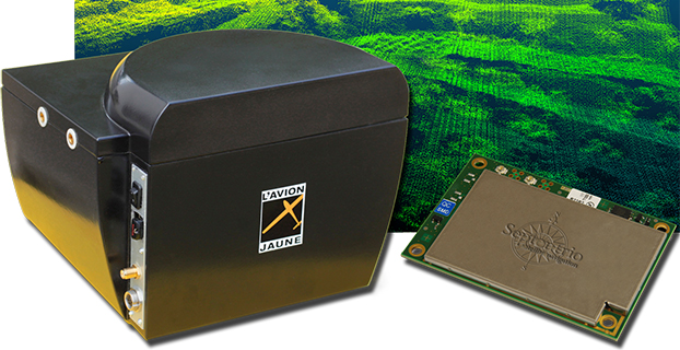
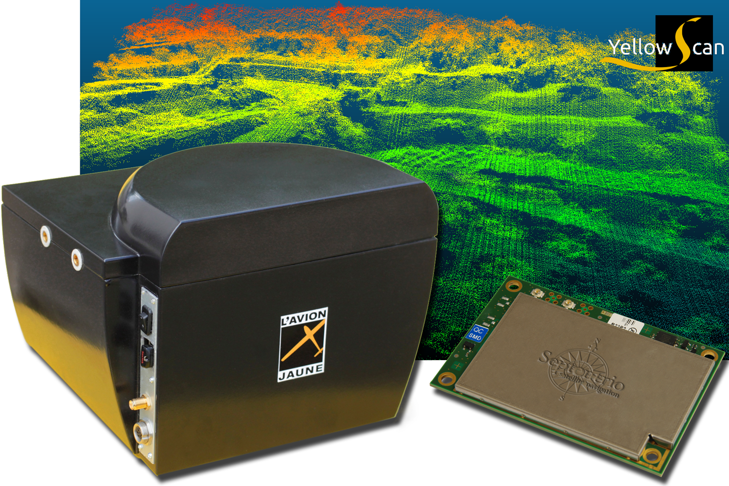
L’Avion Jaune Selects Septentrio’s RTK Technology for UAV Laser Scanner
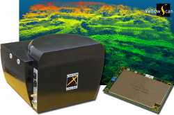
Photo: L’Avion Jaune L’Avion Jaune, a service provider and airborne sensors integrator in the field of aerial surveys, has selected the Septentrio AsteRx-m to equip its YellowScan unmanned aerial system. L’Avion Jaune chose the AsteRx-m for its robustness and low-power consumption, Septentrio said.
YellowScan is the a lightweight all-in-one solution designed to deliver quality aerial surveys carried out using a LiDAR sensor aboard UAVs. The self-contained system integrates into a small package all the necessary equipment for conducting airborne surveys: a 3D laser scanner, an AHRS, a controller, an autonomous power supply module and the AsteRx-m, a high-performance precision GNSS receiver.
The AsteRx-m provides a compact and low-power solution for precise positioning in difficult environments where the tracking of both GLONASS and GPS satellites allows the receiver to improve the availability and robustness of a positioning solution. Septentrio’s newest RTK models optimally adapt to situations where GNSS signals can be distorted by reflective surfaces and feature unique countermeasures to disturbances, maintaining accurate and stable measurements wherever and whenever centimeter-level accuracy is needed, the company said.
“The easy-to-integrate AsteRx-m has proven to deliver the most reliable and stable RTK performance of all, in a compact and exceptionally low-power consumption module,” said Michel Assenbaum, CEO of L’Avion Jaune. “The AsteRx-m allows us to extend the operational range and capabilities of the YellowScan, a fully autonomous surveying solution dedicated to UAVs. We have tested the solution in various environments across the world and have never seen it falter.”
“We are delighted that L’Avion Jaune, a respected expert in designing unmanned-aerial remote sensing solutions, has validated the excellent performance of our ultra-compact GNSS receiver,” said Jan Van Hees, head of business development at Septentrio. “We are impressed to see how much interest YellowScan has drawn since its introduction and we are very proud to be contributing to the success of a best of breed solution in this highly competitive market.”
-
MobileMapper 120, GIS Software Combine for Solution in Turkey

The Geomatics Group, a Spectra Precision distributor and GIS software developer in Turkey, is achieving excellent success marketing the Spectra Precision MobileMapper 120 handheld GIS mapping device running Mobile GIS software developed by the Geomatics Group, according to Spectra Precision.
MobileMapper 120 uses a Windows open platform enabling it to run any Windows mobile application, including Spectra Precision applications for GIS or Survey, as well as third-party solutions that may better meet local regulations or specific customer requirements. The Geomatics Group has taken advantage of the Windows open platform to develop a specific application and integrated it with the MobileMapper 120 to provide a solution for its Turkish customers.
A Geomatics Group spokesperson says that sales of the MobileMapper 120 are particularly strong in three sectors in Turkey: mapping electrical infrastructure, orthophoto survey, and mapping public land and assets. Recently, 150 units of the MobileMapper 120 with the Geomatics Mobile GIS software were sold to the Turkey General Directorate of National Property to assist in public property management. According to the spokesperson, the sub-meter accuracy of the Spectra Precision MobileMapper 120 and the Mobile GIS software’s fast and easy menu access, hierarchical database and easily modified attribute library were important features in tests conducted by the customer. In another MobileMapper 120 sale earlier this year, 48 units were sold to the Provincial Directorates of Urban Environment for use in 48 different cities.
The spokesperson underscored the accuracy of the MobileMapper 120 that has impressed customers by reporting that one electrical grid customer who compared their ProMark 500 GNSS receiver to a MobileMapper 120, into which the Geomatics Group had installed a flying RTK option and using TUSAGA-Aktip (CORS-TR), found only a five-centimeter difference between the two receivers.
-
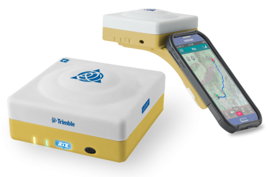
Trimble Takes the Leap with GNSS Bluetooth Device
The Trimble Leap, also shown with a smartphone. Photo: Trimble Trimble is making available the Trimble Leap, a Trimble RTX compatible GNSS Bluetooth device. When enabled with the ViewPoint RTX correction service, Leap delivers submeter accuracy directly to the Terrain Navigator Pro (TNP) Mobile app for iOS and Android devices. The TNP Mobile app allows users to collect markers, tracks and geo-stamped photos in the field, and then sync all the GNSS data into the Terrain Navigator Pro office software.
The TNP Mobile app enables users to:
- Display and navigate routes created in TNP desktop.
- Collect field data such as markers, tracks, photos, videos and audio clips.
- Near real-time sync between phone and TNP map software via WiFi or cellular data connection.
- View data on topo, aerial, and street maps downloaded to phone for offline use. Terrain Navigator Pro offers 1-meter aerial photos for the 48 contiguous United States. The seamless USGS topo graphic maps are based off 1:24K, 1:100K, 1:250K map scales. Alaska is 1:63K and 1:250K.
- Access a compass and other geo-information such as lat/long, elevation, and direction on phone.
- Collect data offline. The TNP mobile app uses the GPS built into the smartphones, so users can collect field data in areas without a cellular or data signal.
Trimble Leap is compact and portable, weighing 9.5 ounces. It snaps to a smartphone or tablet to use as a handheld, can be mounted on a monopole or tripod, or can be magnet mounted to a vehicle. Leap has 16 hours of battery life and uses Bluetooth communication to connect to smart devices for ease of use and flexibility. An onboard micro SD card stores the GNSS observables data for use in the field or the office.
A micro USB port can provide power to Trimble Leap for continuous fixed-mount applications, or it can be used with battery-booster products to extend field work. Trimble Leap is charged by a standard cell phone vehicle accessory charger, a USB connection to a PC, or from a USB AC adapter.
Based on Trimble RTX (Real Time eXtended) technology, ViewPoint RTX delivers better than 1 meter horizontal accuracy 95 percent of the time without the use of a traditional RTK base station or virtual reference station network. ViewPoint RTX is delivered into the TNP Mobile app via cellular data network and is available nearly anywhere in the world.
“Trimble Leap enhances the Terrain Navigator Pro solution by adding a simple way to collect submeter accurate geolocation data with standard Android or iOS devices. Adding accuracy to TNP’s robust field-to-office data collection solution provides a value-add where low-resolution collection is not sufficient. Trimble Leap with TNP Mobile is configured and operational in minutes with little training,” said Larry Fox, business area manager for Terrain Navigator Pro.
Terrain Navigator Pro integrates powerful desktop mapping software, a cloud connected mobile data collection platform (compatible with GPS-enabled iOS and Android devices) and a robust Web portal. TNP users can plan projects in the office, collect data in the field and access projects from the Web—simultaneously. Geo-referenced data such as tracks, waypoints, photographs and video can be shared, updated in near real-time and displayed on the included topographic, aerial/satellite or street base maps.
-
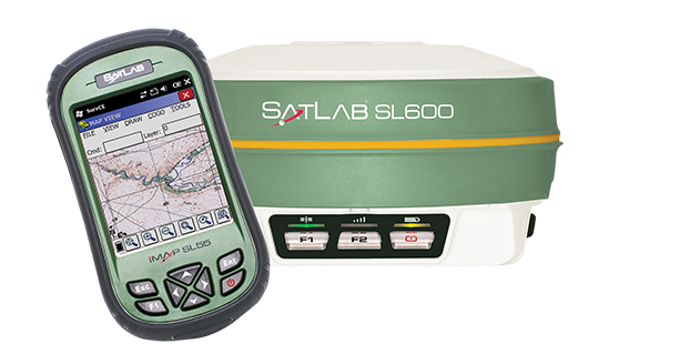
Satlab Launches SL600 on-the-Pole Survey Receiver
The SatLab SL600 GNSS survey receiver. Photo: SatLab Geosolutions AB SatLab Geosolutions AB is now shipping its new SL600 on-the-pole GNSS survey receiver.
SatLab announced the unit earlier this year as the replacement of its SL500 on-the-pole surveying receiver. After a summer of testing and a premiere showing at InterGeo 2014, held in Berlin in October, SatLab is ready to ship the SL600 to its dealer network and customers.
The new receiver is designed to meet the evolving needs of the surveying market, and is designed for general land, marine and construction applications. At the heart of the rugged unit is a 6G GNSS receiver capable of using all six GNSS satellite networks (GPS, GLONASS, BeiDou, Galileo, QZSS and SBAS), providing reliable operation in demanding conditions, SatLab said.
The SL600 is lightweight at 1.2 kg. Its Xenoy housing holds up well to real-world use, according to test results by SatLab, resistant to 3-meter drops and 2 meters of water submersion. The dual hot swappable batteries provide 18-24 hours of continuous field use, depending on the mode of operation.
The SL600 receiver has a new onboard computer running the LINUX operating system, which ensures easy implementation of new functionalities, often a result of customer-specific requirements. Over time, over-the-air firmware updates will be automatically available, adding new features at no additional charge. Users will be notified by the unit to accept the new firmware updates, or refuse them if they wish to keep their units as is.
The SL600 system is available with various communication capabilities. Cellular 3G and Bluetooth as well USB and RS232 connectivity are standard, and an optional internal 2W Pacific Crest XDL radio is also available. Voice notifications notify the user of issues without the need to watch the status LEDs.
The SL600 system kit includes a compact hard carrying case with the SL55 field controller, which can handle large data files with its high-speed processor and expandable memory. Furthermore, the SL55 has an onboard GPS/GLONASS L1 receiver as well as a GSM modem, which makes the unit a good and rugged companion to use in GIS data collection applications.
As part of the close cooperation between Carlson Software and SatLab Geosolutions AB, the SL600 comes with Carlson SurvCE pre-installed and activated. This ensures an “out of the box” experience for the end customer, SatLab said.
-

Trimble RTX Correction Services Now on Geo 7X Handhelds
The Trimble Geo 7 series of rugged, high-accuracy GNSS handhelds will have RTX correction. Photo: Trimble Trimble’s RTX technology-based correction services — Trimble CenterPoint RTX, Trimble RangePoint RTX, and the new Trimble ViewPoint RTX — will be available for Trimble Geo 7X handhelds. Trimble made the announcement at Trimble Dimensions.
Trimble RTX technology provides compatible GNSS receivers with correction services that significantly improve accuracy and reliability in obtaining positions worldwide. Geospatial professionals now have more flexibility to achieve the accuracy required by their highly mobile workflows in real-time, without being tied to a base station or local VRS network, Trimble said.
Available worldwide through an IP connection where cellular communication is available, Trimble RTX offers geospatial professionals flexibility in where and when they are able to work. Operational efficiency and productivity in the field is improved by delivering real-time DGNSS corrections directly to the Trimble Geo 7X handheld. Field challenges, such as obstructed satellites and inaccessible locations, are also minimized with Trimble Floodlight and Trimble Flightwave technology options for the Trimble Geo 7X.
The handheld solution is designed for a variety of industries — such as utility companies, municipalities, and environmental management agencies — in which workers are highly mobile and require a reliable, flexible data-collection and asset management solution.
“We have eliminated the complexities of managing multiple correction sources across a large geographically dispersed project or organization,” said Alain Samaha, business area director of GIS and Software for Trimble’s Geospatial Division. “By offering RTX-based correction services, we simplify their work and deliver the accuracy that our customers require.”
A choice of RTX correction services ranging from 4 centimeters to submeter-level horizontal accuracies is available. Customers can choose the appropriate Geo 7X handheld configuration with the RTX-based correction service that meets the accuracy level and capability required for their job.