Tag: mapping

  • Applanix Brings Trimble CenterPoint RTX Correction Service to Airborne Mapping Products


    Applanix, a mobile mapping and positioning company, is making the Trimble CenterPoint RTX correction service available across its entire airborne mapping portfolio. Applanix is a Trimble Company.

    Using the Trimble CenterPoint RTX correction service, Applanix will be able to deliver these benefits to the aerial survey marketplace:

    • High accuracy — better than 10 cm RMS horizontal after convergence
    • Speed and low cost — no need for setting up base stations, no need to wait for delivery of public-domain ephemeris data
    • Simplicity — deal directly with Trimble (no third-party involvement)
    • More uptime and reliability — use Trimble’s professionally managed, highly maintained private network
    • Ease of use — there is no additional hardware to purchase, integrate or maintain
    • Fast and reliable convergence — 30 minutes or less to full accuracy

    The announcement was made at Trimble’s China Dimensions User Conference. The CenterPoint RTX service for Applanix airborne mapping products is expected to be available in the fourth quarter of 2013.

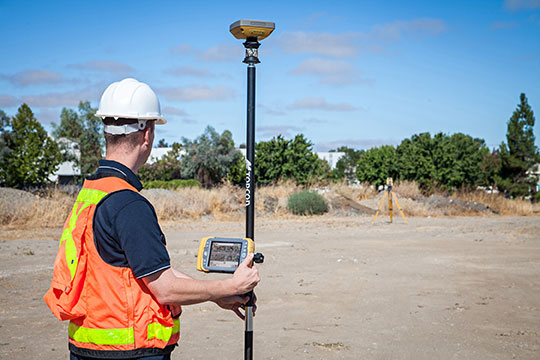
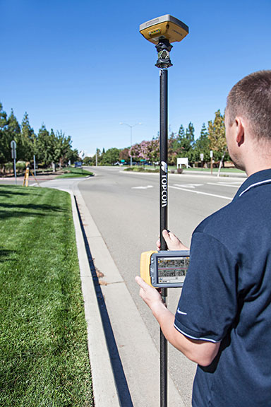
    “The Applanix aerial mapping portfolio is trusted throughout the aerial mapping community to provide highly accurate position and orientation information for directly georeferencing camera and sensor data,” said Joe Hutton, Director of Airborne Products at Applanix. “By integrating the Trimble CenterPoint RTX correction service, we are maintaining our position at the forefront of accuracy, robustness, and high efficiency in airborne mapping.  The CenterPoint RTX correction service gives Applanix products the  ability to achieve accuracy required for many types of mapping projects in real time and post-mission, all without the need for base stations – an industry first.”

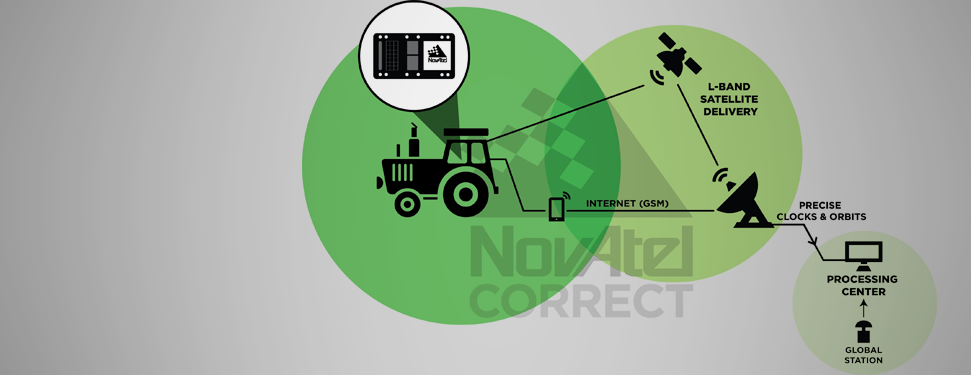
    Trimble CenterPoint RTX correction service is a GPS, GLONASS and QZSS enabled correction service built on Trimble RTX technology.  It provides high-accuracy GNSS positioning without the use of traditional reference station-based differential RTK infrastructure.

    The solution is also compatible with the Applanix POSPac software to achieve the same level of orientation accuracy as when using base stations, all without the need to have an Internet connection or wait for precise ephemeris data to be available.

  • NovAtel Launches Correct OEM Positioning Solution

    NovAtel Launches Correct OEM Positioning Solution

    NovAtel Correct.
    NovAtel Correct.

    NovAtel, Inc., OEM provider of high-precision GNSS positioning products, has launched its NovAtel Correct positioning technology. NovAtel Correct optimally combines data from multiple GNSS satellite constellations with corrections from a variety of sources, to deliver the best position solution possible.

    NovAtel Correct provides integrators with the opportunity to choose pricing and subscription options that best match their OEM business objectives. Delivery of correction data is available via satellite or Internet, depending on the requirements of the application. With NovAtel in control of the entire positioning solution, future innovation including seamless integration with all positioning modes and correction types is assured.

    Designed for NovAtel’s OEM6 high-precision receivers, the NovAtel Correct precise point positioning (PPP) solution delivers decimeter-level accuracy worldwide. L-band delivered PPP corrections from TerraStar are supported by NovAtel Correct without users having to add base-station infrastructure. Developers of land, airborne and near shore applications can purchase subscriptions to TerraStar’s correction service directly through NovAtel.

    “For a number of reasons, many of our customers have been eager for an end-to-end NovAtel OEM positioning service,” said Jason Hamilton, VP, Marketing for NovAtel. “NovAtel Correct rounds out our product and service offering and gives customers one-stop shopping for receivers, antennas and correction services.”

    Satellite and NTRIP-based solutions will be available for OEM6 products in Q1 2014 for all applications requiring decimetre-level positioning.

    NovAtel OEM628 triple-frequency +  L-Band GNSS receiver.
    NovAtel OEM628 triple-frequency + L-Band GNSS receiver.
  • Trimble’s GeoExplorer GNSS Data Collection Adds Remote Positioning Capability

    Trimble’s GeoExplorer GNSS Data Collection Adds Remote Positioning Capability

    Photo: Trimble

    Trimble has introduced the next generation of its Trimble GeoExplorer data collection solution. The new Geo 7X includes an integrated laser rangefinder module, extended GNSS capabilities and improved hardware performance. Together with robust field and office software, the new Trimble Geo 7X handheld can enhance productivity in difficult physical conditions and challenging GNSS environments.

    When faced with either obstructed satellites or inaccessible locations, GIS professionals now have the geospatial data collection tools they need in a single package, Trimble said. For times when occupying a position isn’t possible, users can take advantage of Trimble’s new Flightwave technology. With Flightwave technology, users can capture offset measurements from the Geo 7X’s rangefinder module for direct integration with Trimble data collection software. Users point and shoot to log the position, avoiding dangerous conditions or right-of-way challenges. In addition, Trimble’s field-proven Floodlight technology enhances field productivity when heavy overhead cover obstructs satellite signals.

    Photo: TrimbleThe Geo 7X is compatible with existing and planned GNSS satellite systems — including GPS, GLONASS, Galileo, QZSS and BeiDou — to maximize productivity with additional satellites and ranging signals.

    Featuring a new 1 GHz processor and 4 GB of memory running Microsoft Windows 6.5 Professional operating system, the Geo 7X offers enhanced computing performance. Other standard features include a 4.2 inch sunlight readable LED touch display and a 5 MP camera for geo-tagging assets. For wireless connectivity, the integrated modem allows users to send and receive data via GSM networks as well as Verizon’s CDMA network in the U.S. And with its IP65 rating, the rugged handheld GNSS receiver is sealed against water and dust.

    With the introduction of the Geo 7X, Trimble also delivers updates to its field and office software portfolio to extend Trimble’s end-to-end data collection solutions with new software workflows and compatibility. In addition to the field-proven Trimble TerraSync and Positions software, the Geo 7X now supports the customizable data collection workflows of Trimble TerraFlex software. Consisting of mobile software and Cloud services, TerraFlex offers a fast and efficient way to collect, process and manage data. Field data is automatically synced with a central server to streamline office operations and drive higher productivity.

    ”We believe that true productivity is being able to map assets — the first time, every time and anywhere. We’ve built upon our productivity-enabling Floodlight technology and pushed it forward several steps,” said Alain Samaha, business area director of GIS and geospatial software solutions for Trimble’s Geospatial Division. “Users now can position themselves in the optimal location and accurately measure assets remotely with a single, integrated device together with simple software workflows. The Trimble Geo 7X allows mobile GIS users to be productive wherever they need to work.”

    Photo: TrimbleThe Trimble Geo 7X and supporting software are expected to be available in fourth quarter of 2013 through Trimble’s authorized GIS Distribution Channel.

  • Topcon Adds Vanguard Technology to GRS-1 Receiver

    Photo: Topcon
    Photo: Topcon

    Topcon Positioning Group has added Vanguard technology to the GRS-1 handheld GNSS receiver and field controller.

    “With the addition of Vanguard technology, the GRS-1 fully integrated, dual-constellation, network-enabled receiver and controller optimizes tracking and performance regardless of job site conditions or location,” Scott Langbein, director of product marketing, said.

    Topcon’s 226-channel Vanguard technology with Universal Tracking allows each individual GNSS channel to be fully optimized to track any of the available satellite signals that are supported in today’s GNSS receivers.

    The GRS-1 can be used in various configurations from handheld to network enabled RTK measurement, and grade management. “The system can be configured to perform at various levels of accuracy that fit any budget and application,” Langbein said. Choices include centimeter level, sub-decimeter and sub-meter, with accuracy upgradeability options available.

    Working with Topcon’s Magnet suite of software products, “the GRS-1 streamlines the workflow for surveyors, contractors, engineers and mapping professionals,” Langbein said.

    The GRS-1 with Vanguard has DGPS capability with the internal single frequency antenna for use in GIS and navigation applications. Add the external antenna and connect a GRS-1 rover to a local GNSS network, or Topcon Magnet Relay, for centimeter accuracy RTK performance. Magnet Relay allows a mobile base receiver to host up to 10 rovers through the Magnet Enterprise “cloud.”

    The GRS-1 has an optional 2MP built-in camera, integrated SD memory card slot, and includes an optional internal GSM or CDMA cellular modem and internal GNSS antenna, plus wireless connectivity via wireless LAN or Bluetooth technology.

  • Topcon Announces GR-5 with Vanguard Technology

    Topcon Announces GR-5 with Vanguard Technology

    Topcon GR-5 with Vanguard technology.
    Topcon GR-5 with Vanguard technology.

    Topcon Positioning Group has released the GR-5 receiver with Vanguard technology, designed to optimize tracking and performance.

    “The GR-5 is a next-generation GNSS receiver, built on multi-constellation integrated technology pioneered by Topcon,” said Scott Langbein, director of product marketing.

    “Now with the inclusion of Topcon’s exclusive 226-channel Vanguard technology with Universal Tracking, and the power of full-wave Fence Antenna technology that provides multipath rejection in difficult environment, the GR-5 operates with unsurpassed sensitivity, tracking accuracy and performance.”

    In addition to Universal Tracking, Vanguard technology includes Quartz Lock Loop for signal processing in heavy vibration applications and Intelligent Tracking Optimization to select the best combination of available satellite signals.

    “At any time, end-users can track all available satellite signals and be assured of getting accurate measurements regardless of environmental conditions,” Langbein said.

    Additional features of the GR-5 include:

    • Cellular and radio: The GR-5 has both cellular and radio communications, which allows it to be used in radio-based RTK and network RTK systems;
    • Long-range UHF radio: The top-mounted radio antenna extends the range of RTK radio performance;
    • Operating time: GR-5 hot-swappable batteries are designed for full-day operation;
    • MAGNET Field: MAGNET Field software can be used with the GR-5 RTK system, providing the ability to share data to cloud storage and connect field crews to each other and the office.
  • Spectra Precision Shows off New and Updated Products for Surveying

    Spectra Precision Shows off New and Updated Products for Surveying

    Photo: Spectra Precision
    Photo: Spectra Precision

    Spectra Precision introduced at Intergeo this week new and updated products to expand its portfolio of solutions addressing the needs of the mainstream surveying and construction markets. Intergeo 2013 is a geodesy, geoinformatics and land management trade event being held in Essen, Germany.

    “Earlier this year, we introduced a new reflectorless entry-level total station, the lightweight ProMark 700 RTK Network Rover and the Layout Pro construction layout software suite. With our latest additions, the Spectra Precision portfolio continues to evolve to meet the changing needs of our users,” said François Erceau, general manager of Spectra Precision’s GeoInstruments Business Unit. “Spectra Precision now offers one of the broadest and most complete portfolios of survey and construction products in the industry — from construction lasers and total stations to survey GNSS receivers and GIS handhelds — all from a single supplier that customers can trust.”

    New and updated Spectra Precision products include:

    • Spectra Precision EPOCH 50 firmware 4.81 – now supports RTK positioning using the Chinese BeiDou open service GNSS satellite signals. Adding the BeiDou constellation to the full range of GPS and GLONASS signals already tracked by EPOCH 50 further boosts the capabilities of this GNSS receiver to enable faster initialization and performance, even in conditions where satellite visibility is obstructed due to tree canopy or tall buildings.
    • MobileMapper 120 Decimeter Edition this new kit, based on the MobileMapper 120 handheld GNSS receiver, includes the Flying RTK, GLONASS tracking and NTRIP correction options. With accuracy of 20cm or better, the Decimeter Edition kit is a competitively priced solution for precise Mobile Mapping applications.
      • ProFlex 800 firmware version 1.9 – now supports GLONASS-only mode and tracking of QZSS signals to meet the needs of specific markets (Russia and Japan, respectively). This updated firmware also improves RTK performance in VRS networks, particularly in challenging GNSS environments, through Z-Blade technology enhancements.
    • Layout Pro Field and Office software – a recent release of the Layout Pro field software added support for the FOCUS 30 Robotic Total Station, offering the highest level of productivity and accuracy in a construction layout solution. The Layout Pro version 2.1.1 update now includes language packs for major markets worldwide, in addition to many other minor enhancements. Customers with a current Layout Pro maintenance agreement are eligible to download this update from www.spectraprecision.com.
    • Survey Basic software for total stations – further enhancements to this entry-level software application make for the simplest starting point, with workflows that mirror the familiar Nikon-style FOCUS 6 user interface in a modern full-color touch-screen instrument (FOCUS 8). Further language packs have been added, including Czech, Traditional Chinese, Korean and Polish.
    • Survey Pro Field software version 5.4 –  the latest release of this award-winning survey field software includes many new features and enhancements such as:
      • Updated Digital Terrain Model (DTM) features and interface
      • Support for new GNSS constellations and an improved GNSS workflow
      • Additional Active Map enhancements that make it easier than ever to work directly from the map screen
      • Updated point staking routines and a new interface for building design point lists
      • A new Plane and Vertical Angle Offset routine
      • A new electronic compass display in various map screens
      • Enhanced total station and GNSS setup routines
      • An improved Code/Description entry and display system

    Customers with a current Survey Pro maintenance agreement are eligible for this update and can download the software from .

    • Spectra Precision Survey Office software v3.10 and v2.95 ­– both versions are companions to Survey Pro 5.4 field software and FAST Survey field software, and offer enhanced baseline processing with more reliable outlier detection and improved accuracy statistics. Additionally, version 3.10 features a new customized ribbon UI and is optimized for 64-bit PCs (with notably faster processing).

    These new and updated Spectra Precision products are now available for order through the Spectra Precision global reseller network.

  • Juniper Systems’ New Rugged Handheld Features 4.3-Inch Touchscreen

    Juniper Systems’ New Rugged Handheld Features 4.3-Inch Touchscreen

    Photo: Juniper Systems
    Photo: Juniper Systems

    Juniper Systems has announced the availability of a new rugged handheld, the Archer 2. With radical improvements over the first generation Archer, the Archer 2 promises better overall performance with an astonishingly bright display, an extra-long battery life, enhanced GPS capabilities, and rugged IP68 construction.

    Juniper Systems will be showcasing the Archer 2 at the Intergeo 2013 conference from October 8-10 in Essen, Germany.

    According to the announcement, the latest generation handheld incorporates several new technological advancements. Sporting a custom 4.3-inch Illumiview high-visibility display, the Archer 2’s screen brightness has been well received by reviewers. Its battery features a unique technology inspired by the technology used in hybrid car batteries to prevent excessive battery drainage in low temperatures. Referred to as Overtime Technology, this Archer 2 super battery will last 20 hours and up on one charge.

    The new device is the first Juniper Systems handheld to feature a capacitive touchscreen for improved response and ruggedness. The Archer 2 also includes a glove-friendly numeric keypad for rapid data entry, a feature which many Juniper Systems customers highly value. Like other Juniper Systems handhelds, the Archer 2 is built to very strict standards at its ISO 9001:2008-certified facility, having been tested to MIL-STD-810G and given a top IP68 rating for dust and water.

    Photo: Juniper Systems
    Photo: Juniper Systems

    “We have been looking forward to the release of the Archer 2 for some time,” said Rob Campbell, CEO at Juniper Systems. “We have taken special care in addressing the needs of customers in the design of the Archer 2. It is a product of utmost quality, and the excellent reviews we have received on our Archer 2 beta units have made us very optimistic that the Archer 2 is going to meet our customers’ needs exceptionally well.”

  • Trimble Adds Tilt Compensation to R10 GNSS Surveying System

    The Trimble R10 Surveying System.
    The Trimble R10 Surveying System.

    Trimble announced today several enhancements to the Trimble R10 GNSS Surveying System designed to drive field productivity to a new high. With sophisticated tilt-compensation technology, CenterPoint RTX correction service support, and updated field and office software, the R10 platform demonstrates Trimble’s commitment to driving improved surveying productivity.

    The announcement was made at Intergeo 2013, being held October 8-10 in Essen, Germany.

    “Innovations in techniques such as our tilt compensation technology can have a pervasive impact on the everyday surveying experience,” said Elmar Lenz, business area director of GNSS Solutions for Trimble’s Geospatial Division. “With our innovative approach to total surveying workflow, Trimble is redefining the way surveying work is done.”

    The Trimble R10 is now augmented to further speed GNSS field work. With its new internal tilt-compensation, Trimble SurePoint technology takes field efficiency to the next level. The system will automatically adjust for pole-tilt up to 15 degrees from plumb, saving time and reducing fatigue. With tilt compensation, surveyors can now utilize GNSS in more situations and with 100 percent measurement traceability.

    In addition, Trimble introduced its high-accuracy correction service, CenterPoint RTX, into the geospatial market with support in the Trimble R10. Powered by Trimble RTX technology, CenterPoint RTX is a subscription service that delivers real-time 4 centimeter (1.5 inch) or better corrections via satellite directly to the receiver without requiring the use of a base station, VRS network, or investment in additional hardware.

    Both Trimble Access field software and Trimble Business Center office software have been updated to streamline data flow and automate data processing. Faster in the field and more flexible in the office, Trimble’s premium GNSS surveying system enhances the entire surveying workflow.

    The updates to Trimble R10 GNSS System, CenterPoint RTX service support, Trimble Access version 2013.40 and Trimble Business Center version 3.10 are expected to be available in the fourth quarter of 2013 through Trimble’s Geospatial Division distribution network. For current R10 users, the tilt-compensation feature and CenterPoint RTX support will be available through a free firmware update.

  • Carlson SurveyGNSS for Post Processing Launched at Intergeo

    Carlson SurveyGNSS for Post Processing Launched at Intergeo

    SurveyGNSS-screen-shot
    Carlson SurveyGNSS post-processing program

    Carlson Software Inc. has developed the new Carlson SurveyGNSS post-processing program, which it introduced today at Intergeo 2013, being held in Essen, Germany. The program is designed for surveyors and positioning professionals looking to achieve centimeter accuracy when working on the edge of their RTK infrastructure, perform sub-centimeter positioning, or provide the highest quality assurance to their customers.

    The data post-processing solution is tightly integrated into the Carlson field and office workflow. SurveyGNSS is designed to accept GNSS data from any receiver in RINEX format. Furthermore, it will also accept proprietary GNSS data in an increasing number of manufacturer formats including NovAtel, Hemisphere GNSS, Altus/Septentrio, and Javad. Additional manufacturer formats will be added in concert with manufacturer cooperation and customer demand.

    “The software has been tested extensively on data sets from around the world with very good results and feedback,” says Bruce Carlson, president of Carlson Software. “Many of our business partners are planning to carry SurveyGNSS and have participated in our pre-release testing.”

    Carlson SurveyGNSS will process GNSS observations in traditional static, “stop and go” (static-kinematic), and kinematic (moving) antenna positioning modes. The software provides a straightforward, workflow-oriented user interface, which includes an overview map and the observation files, computed vectors, and positions presented in fully functional spreadsheet-like grids.

    In addition, Carlson SurveyGNSS provides:

    • A highly autonomous “hands-free” baseline processor offering on-the-fly ambiguity resolution, automated cycle slip detection/removal, and more for baselines up to 200km (125 mi).
    • Automated search and retrieval of reference geodetic control and GNSS observations from public data sources such as the National Geodetic Survey and Continuously Operating Reference Station (CORS) networks in the United States.
    • Rigorous least squares adjustment and analysis of all computed vectors.
    • Seamless integration with downstream applications from Carlson Software and other vendors.

    Carlson SurveyGNSS is being developed in partnership with WaSoft of Dresden, Germany, and its line of GNSS software technologies.

    “SurveyGNSS helps make our survey product line the most extensive in the industry, from field data collection through all forms of processing to as-built mapping and plat drafting,” Carlson adds. “Our flexible licensing arrangements allow single users to process the field data of any number of crews using a wide range of GNSS equipment.”

    Announced at Intergeo in Essen, Germany, Carlson SurveyGNSS is slated to be available from your local Carlson representative or dealer by December 1.

  • Trimble Releases CenterPoint RTX Correction Service into Geospatial Markets

    Trimble announced today that its Trimble CenterPoint RTX correction service will be available to survey and land administration professionals around the world. Powered by Trimble RTX technology, the GPS, GLONASS and QZSS enabled correction service can offer better than 4 centimeter (1.5 inch) repeatable horizontal accuracy, without requiring the use of a base station or local VRS network.

    The announcement was made today at Intergeo 2013, being held this week in Essen, Germany.

    In addition to previously announced Agriculture devices, the CenterPoint RTX correction service is now compatible with the Trimble ProXRT for Land Administration and the Trimble R10 GNSS receivers. The worldwide subscription service is expected to be available to geospatial users in the fourth quarter of 2013.

    Delivered via L-band satellite, CenterPoint RTX is designed for geospatial professionals who are not using RTK as the primary correction source. Advantageous in remote areas that lack local infrastructure and/or cellular coverage, the corrections are delivered directly to the GNSS receiver. No additional hardware, including radios, antennas, or even cellular data plans, is required to use the correction service.

    “By combining global coverage, fast initialization times, and high-accuracy correction data, Trimble CenterPoint RTX offers geospatial professionals unprecedented operating freedom,” said Patricia Boothe, general manager of Trimble’s Positioning Services Division. “We are committed to offering field-proven positioning corrections to address a variety of users’ needs across applications and markets, starting with agriculture and now reaching into the geospatial markets.”

  • Carlson Launches Two Handhelds at Intergeo

    Carlson Launches Two Handhelds at Intergeo

    Carlson Software has introduced a new and improved version of its affordable Qmini data collector. The rugged, but lightweight Qmini2 provides fast processing, yet fits comfortably in one hand.

    Carlson also launched the Carlson MINI2 data collector, which is more rugged, fast, and reliable than its predecessor. It comes with a numerical keyboard for easy coding of points.

    Both products were introduced at Intergeo, being held October 8-10 in Essen, Germany.

    Photo: Carlson Software
    Photo: Carlson Software

    The Qmini2. Weighing 11 ounces (315 grams), the Qmini2 includes a 5 megapixel camera and has a 3.7-inch (480 x 640) sunlight-readable display and comes with a stylus for ease of use. Other specifications include:

    • Works on Windows Mobile 6.5 OS with a PXA310 processor 806Mhz, 256 RAM
    • Provides 8GB non-volatile data storage plus a micro SD card slot
    • Comes with Bluetooth (200-250 meter range to CRx with BT handle), WiFi, Internal GPRS module (data and voice) capabilities
    • Has an internal 32-channel GNSS receiver (GPS + GLONASS) with SBAS (WAAS, EGNOS, MSAS) support
    • Rated IP65 waterproof and dustproof

    The Qmini2 comes with two batteries, a U.S. wall charger, and a soft carrying case. It may be purchased with Carlson’s SurvCE data collection software on board, or with Carlson GIS360, which uses both GIS and surveying technology in the field to collect data. For crash or crime reconstruction, The Qmini2 may also be used with Carlson’s CSI Mobile software.

    For more information or to see the Qmini2 in action, stop by the Carlson Stand #3.097, Hall C, or outdoors at #100 at Intergeo, Oct. 8-10 in Essen, Germany.

    The Carlson MINI2.
    The Carlson MINI2.

    The MINI2. Manufactured to Carlson’s exacting specifications by Juniper Systems, the MINI2 has an extra-large 800 × 480 TFT display for easy viewing of survey data and comes with a fast 1.0-GHz processor. It comes with an integrated 3G modem, 5-megapixel camera, and GPS/GNSS module.

    Its scratch-resistant, touchscreen display is highly readable in both low light and glaring sunshine, providing a sharper image together with notable durability in tough conditions. With a dustproof and waterproof rating of IP68, the Carlson MINI2 also meets the MIL-STD-810G military standard.

    The Qmini2 will be available for purchase from your local dealer on November 1.

    Both products can be viewed at Intergeo Stand #3.097, Hall C, or outdoors at #100. at Intergeo.

  • Topcon’s Hybrid Positioning Combines GNSS, Optical Measurement

    Topcon’s Hybrid Positioning Combines GNSS, Optical Measurement

    Photo: Topcon Positioning Group
    Photo: Topcon Positioning Group

    Topcon Positioning Group announces a new technology — Hybrid Positioning — that increases efficiencies and improves productivity on job sites, regardless of conditions, terrain or location. Hybrid Positioning is enabled through the Topcon Magnet software suite, a Topcon enterprise solution for the geomatics industry.

    The new Topcon technology allows precise positioning professionals in the survey, construction, civil engineering and GIS industries to simultaneously connect to GNSS signals and standard robotic measurements on a single rover pole.

    “This extremely clever and unique combination of GNSS and optical measurement is aimed squarely at improving a company’s profitability by allowing the use of GNSS positioning and optical positioning data at the same time,” said Ewout Korpershoek, chief marketing officer of Topcon Positioning Group. “When used with Topcon Magnet software, Hybrid Positioning improves field measurement efficiency at every phase of a project. With Hybrid Positioning technology, the key is versatility. For example, when line-of-sight is blocked, shots can be easily and quickly measured with the GNSS receiver. Now it is so easy to combine a standard Topcon robot and GNSS receiver to guarantee an integrated solution for the highest performance and productivity.

    Photo: Topcon Positioning Group
    Photo: Topcon Positioning Group

    “Combine these two proven solutions, plus advanced Magnet Field software, and you have Hybrid Positioning technology,” Korpershoek said. “By utilizing both GNSS and optical measurement, any project can be completed faster and with unsurpassed accuracy. By adding Magnet cloud-connected data workflow, truly outstanding increases in productivity and cost savings are assured.”

    The new technological breakthrough has four key components: Hybrid Lock, Hybrid Resection, Hybrid Switch and Auto-localization.

    Hybrid Lock allows accurate prism tracking by simply turning the instrument toward the prism location. Hybrid Resection ensures quick job site setup, as well as establishing RTK and geodetic coordinates. Hybrid Switch ensures a quick changeover from GNSS to optical measurement with a single touch. Auto-localization utilizes Bing Maps background, multi-point localization and works with RTK and NMEA positioning.

    “Regardless of job site location or adverse conditions or terrain, Hybrid Positioning systems will perform faster in the field than other instruments and with more versatility than an RTK-only system,” Korpershoek said.