Tag: mapping

  • A Comparison of Free GPS Online Post-Processing Services

    On October 1, the U.S. federal government shut down and furloughed 800,000 non-essential workers. While services considered essential remained active, those considered non-essential services, like the National Geodetic Survey’s Online Positioning User Service (OPUS), were shut down. OPUS is a free, online GPS post-processing service. If you try to access www.ngs.noaa.gov, the following screen will be displayed:

    NGSShutdownScreen

    For those of you who rely on OPUS for GPS post-processing, now is a great time to try one of the other seven online post-processing services available and not subject to the U.S. federal government. Yes! I wrote seven, and the results from those seven are comparable to OPUS. The other seven, free online GPS post-processing services are:

    CSRS-PPP: Canadian Spatial Reference System, Natural Resources Canada

    AUSPOS: Geoscience Australia

    GAPS: University of New Brunswick

    APPS: Jet Propulsion Laboratory

    SCOUT: Scripps Orbit and Permanent Array Center (SOPAC), University of California, San Diego

    magicGNSS: GMV

    CenterPoint RTX: Trimble Navigation

    My colleague Mark Silver, creator of the X90-OPUS receiver I wrote about a few months ago, embarked on an effort to run test data through each of the online post-processing services to demonstrate that there are free, online GPS post-processing services available worldwide that produce results comparable to OPUS. The following report is the result of his efforts:


    A Comparison of Free GPS Online Post-Processing Services

    By Mark Silver

    You are probably familiar with the National Geodetic Survey’s OPUS suite of online post processing tools (OPUS-Static, OPUS-Rapid Static and OPUS-Projects.) These services are capable of producing centimeter-level positioning from static GPS observations. What you may not realize is there are at least six viable alternatives to OPUS.

    All are free, easy to use, provide world-wide coverage, and generate surprisingly similar results.

    Since each uses a unique baseline tool and processing strategies they form an excellent reality check against each other.

    IGS orbits and the IGS permanent CORS arrays are used by many of the services, however some use proprietary equipment arrays and orbit products that provide additional redundancy.

    How comparable are these services? Which one is the best?

    Criteria for Comparing

    Comparing results is a difficult proposition:

    • The true/correct answer for any site is unknown.
    • What grading scale should be used? Should elevation differences be weighted differently than horizontal differences?
    • Should the peak-to-peak range or the standard-deviation be prized?
    • Should comparisons be made on long 24-hour data sets or short 2-hour occupations?
    • Is a single data set sufficient for a meaningful comparison or are multiple data sets preferable?
    • Should a service be ‘thrown out’ of consideration because the solutions are substantially different from the mean?

    The answer to all of these questions is “it depends.” Your evaluation will depend on your specific application.

    For this evaluation, the following rules governed the data set selection:

    • Choose a site known to be stable with a clean EMI environment.
    • Use 24-hour observation sets to enable ‘best case’ processing.
    • Use a sufficiently large data set, 32-consecutive days, to expose trends.
    • Choose a time period, 90-days in the past, so precise orbits are available to reduce ephemeris effects.
    • Only consider GPS data.
    • Use default settings for every option on each processing service.

    Scoring

    This would not be as interesting without a little competition.

    To keep the evaluation simple, the sum of the X, Y and Height range will be the score and the services will be ranked from lowest score to highest score, with the low score being the ‘best.’

    Range was chosen as an indicator of the expected maximum error that might be encountered if only a single 24-hour file was observed.

    The combined range rewards a processing scheme that best estimates delays, interference, clock errors and other sources of change that occurred during the 32-day trial.

    Remember that the every aspect of this ‘competition’ is arbitrary: from the selection of observation sets, to the final scoring system.

    The real take-away from this evaluation is not that one service is better, but how close all of the services are to each other.

    Two services (JPS’s APPS, magicGNSS) won’t be acceptable to the average user and a third (RTX Centerpoint) may not work for some users based on receiver and antenna support. Details of these problems are presented with the service descriptions below.

    The Test Data

    SGU1 in St. George, UT USA was chosen as the observation base. The observations consist of 32 consecutive days (May 3, 2013 through June 3, 2013), 24-hour observation files, 30-second interval, GPS only data. The data files were downloaded from the NGS CORS archive.

    Each of the 32 files were submitted to each of the processing services and the results have been tabulated for X, Y and Ellipsoid Height. All data is presented in IGS08 current epoch framed coordinates. All data has been projected to UTM Meters for these comparisons.
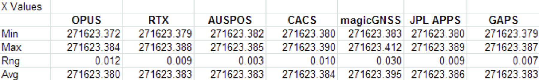
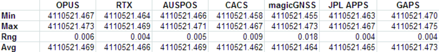
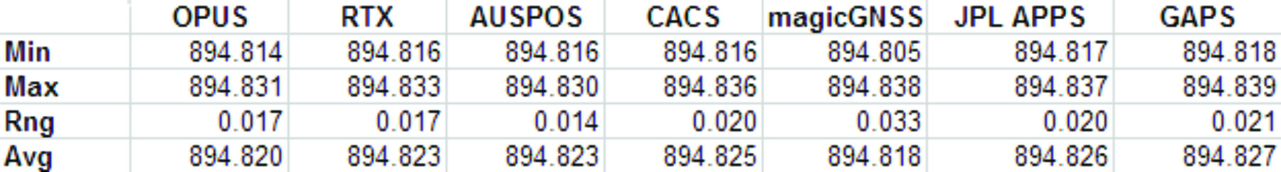
    The Average Values

    Remember, the real story is how close each of these services produce results to one another. Let’s look at the average positions from each service and the difference from OPUS:

    Fig 1: Average Solution Difference from OPUS
    Fig 1: Average Solution Difference from OPUS

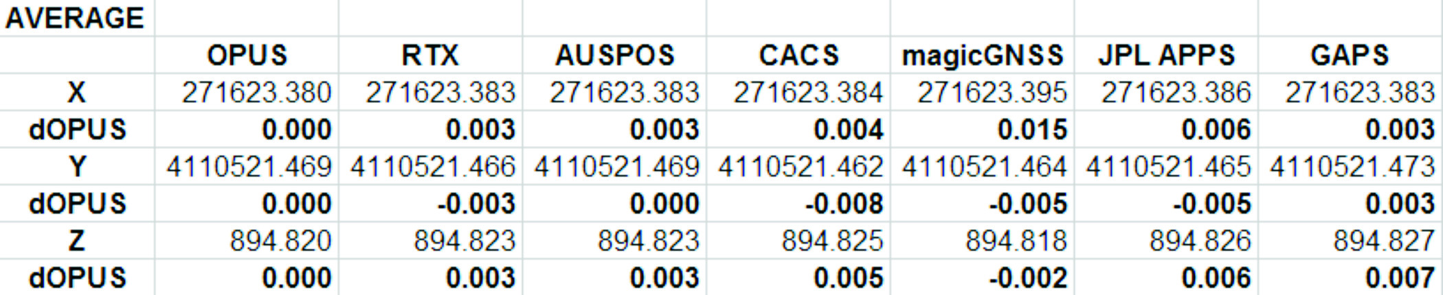
    As you can see in Figure 1 above, the services were generally within 5mm of OPUS in X, Y and Height.

    Position Tracking vs. Time

    Fig 2: Service Results X vs. Time
    Fig 2: Service Results X vs. Time


    Fig 3: Service Results X Range, Average
    Fig 3: Service Results X Range, Average


    Fig 4: Service Results vs. Time
    Fig 4: Service Results vs. Time


    5_YGrid
    Fig 5: Service Results Y Range, Average


    Fig 6: Service Results Z vs. Time
    Fig 6: Service Results Z vs. Time


    Fig 7: Service Results Z vs. Time
    Fig 7: Service Results Z vs. Time


    And the Winner Is…

    Following are the scores, based on the combination of X, Y and Height range:

    Fig 8: The Scores
    Fig 8: The Scores


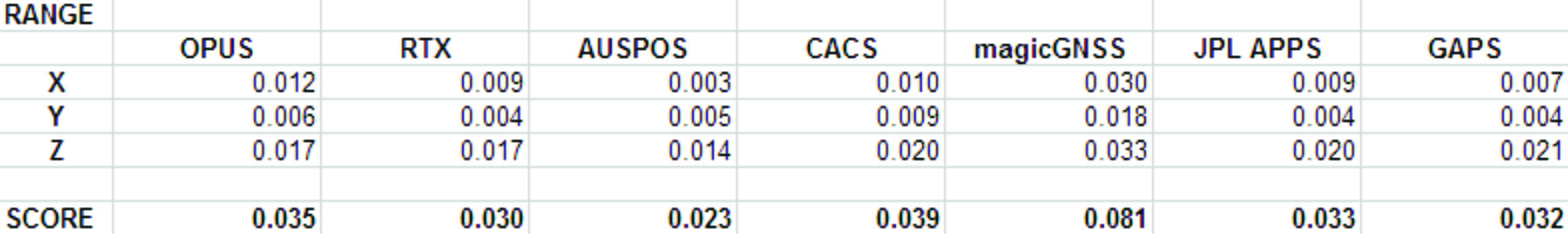
    Score ranking (remember this is just for fun as the services provided remarkably similar results):

    1. AUSPOS
    2. CenterPointRTX
    3. GAPS
    4. APPS
    5. OPUS
    6. CSRS-PPP
    7. magicGNSS

    There is a significant issue in the JPL APPS’s reported output positions, which will keep it from being of any use to most users. magicGNSS’s results are significantly different than the other services. User’s should independently evaluate magicGNSS’s suitability for their purpose. SOPAC’s SCOUT could not be evaluated because it patently does not support either the receiver or antenna that was used at the test site.


    AUSPOS: Geoscience Australia

    Score: 0.023

    Submittal Page: http://www.ga.gov.au/bin/gps.pl

    AUSPOS is a free service from Geoscience Australia. Access is via a simple web interface, the antenna height and type are entered along with a email address for the returned report set. File submission is via FTP or directly from the web interface.

    The returned PDF report is the best looking of the reviewed services and includes a Processing Summary showing a map of the CORS sites that were used in the solution. SINEX files are also available.

    AUSPOS uses the Bernese GNSS Software for processing baselines, IGS orbits and IGS network stations. Solutions are available for anywhere on the earth.

    RINEX files need to be at least 1-hour in length, 6-hour files are recommended. Compact RINEX files are also accepted. Files may be compressed with UNIX, Hatanaka, ZIP, gzip or bzip compression.


    Centerpoint RTX Post Processing: Trimble Navigation Limited

    Score: 0.030

    Submittal Page: http://www.trimblertx.com/UploadForm.aspx

    CenterPoint RTX Post Processing is a free service offered by Trimble.
    It works anywhere in the world and is based on a proprietary Trimble 100+ worldwide CORS network. Accuracy is 2 cm with 1-hour of observation data; 1 cm with 24-hours. Files longer than 24-hours are not accepted.

    RTX uses GPS, GLONASS and QZSS tracked SV’s.

    The reported output frames include ITRF2008 at current epoch and a user selectable frame like NAD83/2011 2010.0. RTX is one of the few services that will directly export NAD83 framed results.
    A single page PDF and a XML result file are returned by RTX. Unfortunately, it is not possible to copy numerical results from the read-only PDF result file to the clipboard.

    RTX supports a limited number of receivers (Trimble) and a relatively small subset of IGS modeled antennas. For this test, TEQC was used to stuff the RINEX headers with a comparable Trimble receiver to the actual Ashtech ProFlex 500 receiver that is in use at SGU1. This was all that was required to spoof an accepted device. If the antenna had not been listed, it would have been necessary to spoof the antenna and adjust the height to reflect the difference in L1 phase center offset.


    GAPS: University of New Brunswick

    Score: 0.032

    Submittal Page: http://gaps.gge.unb.ca/indexv520a.php

    GAPS is an ongoing project at the University of New Brunswick and was developed by the Department of Geodesy and Geomatics Engineering.

    File submission is by a web page and GAPS provides a large number of user inputs and potentially allows the highest level of customization of any of the reviewed services:

    • You may enter a priori coordinates, and a priori constraints
    • GAPS accepts static or kinematic files
    • You can set the elevation mask
    • The Neutral Atmosphere Delay model is selectable
    • Earth Body Tides and Ocean Tidal Loading can be applied or disabled

    GAPS only processes GPS data (no GLONASS.)

    Submitted filenames must adhere to the SSSSDDDh.YYt file format. GAPS accepts RINEX and compact RINEX files, they may optionally be gzip, unix compressed or ZIP compressed.


    APPS: Jet Propulsion Laboratory

    Score: 0.033

    Submittal Page: http://apps.gdgps.net/apps_file_upload.php

    WARNING! APPS only reports the derived position to the nearest decimeter-meter in geographic (lat/lon) coordinates, while reporting ECEF coordinates to a fraction of a millimeter. If you choose to use APPS, you will need to manually convert the ECEF XYZ to geographic coordinates.

    JPL’s APPS is based on GIPSY-OASIS (currently version 5). APPS uses NASA’s 70+ Global GPS Network plus densification from other systems (100+ total receivers distributed globally.) Solutions are typically available with 5 seconds delay from observation.

    APPS is easy to use, you just specify a file to upload and then click on ‘Upload’ it takes only 15 seconds to get a result after the file upload is complete. You can optionally register for a free account and use email or FTP for bulk uploads.

    APPS also has receiver Live Performance Monitoring: (http://www.gdgps.net/monitoring/index.html) which generates a real time graph of three receivers spread through the world.


    OPUS: U.S. National Geodetic Survey

    Score: 0.035

    Submittal Page: http://www.ngs.noaa.gov/OPUS/

    OPUS solutions are the most common PPP Post-Processed solution in the United States. Two flavors of OPUS are available for single points:

    1. OPUS-Static: Available worldwide, requires 2-hours of data
    2. OPUS-Rapid Static: Available with sufficient nearby CORS stations, requires 15-minutes of data

    Long occupations (6+ hours) result in excellent horizontal and GPS-derived ellipsoid heights.

    The new OPUS-Projects service processes multiple receivers through multiple sessions to a final processed network adjustment.


    CSRS-PPP: Natural Resources Canada

    Score: 0.039

    Submittal Page: http://webapp.geod.nrcan.gc.ca/geod/tools-outils/ppp.php

    Before using CSRS-PPP, you will need to register for a free user account.

    CSRS has a fantastic desktop application named PPP-Direct that you can just drag and drop files onto. PPP-Direct automatically submits the file and saves all typing, greatly reducing the chance of error.

    CSRS-PPP uses both GPS and GLONASS (if available) observables. Ocean Title Loading corrections can be overridden.

    CSRS-PPP will accept single frequency files for processing. CSRS will accept RINEX and Compact RINEX, and will decode ZIP, GZIP and unix compression formats.

    CSRS-PPP has a fantastic PDF report, a .csv file detailing results epoch by epoch and a great machine readable summary file.

    The desktop submission tool, coupled with the great output reports made CSRS-PPP my favorite tool.


    magicGNSS: GMV

    Score: 0.081

    Submittal Instructions: http://magicgnss.gmv.com/ppp/

    magicGNSS Blog: http://magicgnss.gmv.com/wordpress/

    magicGNSS accepts emailed files and returns solutions by email. Turnaround time is fast and features a nice PDF report plus SINEX, receiver clock bias files, tropospheric delay, KML trajectory and RINEX CLK clock bias files.

    Static and kinematic files with observations from GPS, GLONASS are processed by magicGNSS and the service reportedly Galileo-ready.

    magicGNSS uses a subset of IGS stations to provide core coverage.


    SCOUT: Scripps Orbit and Permanent Array Center (SOPAC). University of California, San Diego

    Scout accepts RINEX and compact RINEX files, compressed (Z, gz, ZIP) submitted from an FTP site or pushed onto a provided FTP server.

    Files must be generated on a limited subset of receivers and antennas. While the IGS antenna and receiver files are the basis for acceptable devices, not all IGS-listed devices are on the allowable device list. SCOUT documentation specifically warns against spoofing devices and antennas.

    SCOUT uses the GAMIT processing engine.

    Because the test data for this article is from a unsupported receiver and the submittal process requires a FTP host server with anonymous access which most users will not bother with, the output from SCOUT was not evaluated.


    Conclusion

    The similarity of results between all of the services I processed is amazing. That they differ only by millimeters demonstrates the robustness of the algorithms and processes they use.

    The difference between AUSPOS, RTX, GAPS, OPUS and CSRS-PPP solutions are negligible. For important positioning projects, it undoubtedly makes sense to use them all.

    For locations in the United States, OPUS and RTX return NAD83-2011 framed results. Only OPUS returns derived orthometric heights using GEOID12A. While OPUS has more provenance than the other services, it is easy enough to submit important observations to multiple services as a reality check for important positions.

    ###

    As you read from Mark’s report above, even though OPUS is shut down until the U.S. Congress can resolve its differences, don’t let that stop you from processing your GPS static sessions. However, some level of due diligence on your part is needed as requirements vary for each service. For example, static sessions for the OPUS-RS service can be as short as 15 minutes while other services require two hour GPS static sessions. Furthermore, some services process GPS L1 data while others require both GPS L1 and GPS L2 observations.

    See you next month.

    Follow me on Twitter at https://twitter.com/GPSGIS_Eric


  • Nexteq Navigation Launches New Version of NexGeo GIS Software Suite

    Nexteq Navigation Launches New Version of NexGeo GIS Software Suite

    Nexteq's NexGeo Office.
    Nexteq’s NexGeo Office.

    Nexteq Navigation has officially released the next version (V2.0) of its GIS data collection suite, NexGeo. The suite consists of a mobile application for GNSS handhelds to collect and organize GIS data, as well as a desktop application used to customize and organize projects, manage field crews, and integrate with other data formats.

    NexGeo aims to provide a complete solution, from augmenting accuracy to a user-friendly, efficient data-collection tool. An improved user interface provides seamless access to Nexteq’s positioning algorithms, notably in the PPP field, including SBAS-based Freedom algorithm, Internet-based i-PPP global services, and traditional RTK, all available in the field as well as post processed where necessary.

    The latest version of the software contains a slew of improvements and new features, Nexteq Navigation said. NexGeo Mobile on the handheld is redesigned to provide intuitive shortcuts to the software’s main functions directly on the dashboard, simultaneously presenting a panoramic view of working mode, data quality, and handheld status. Improvements of NexGeo Mobile include pausing and resuming features, quick navigation to preset waypoints with compass or map view, offset feature collection using data from a laser rangefinder, and enhanced options of Feature Cloning, Filtering, and Updating.

    When managing projects, post processing the data and tracking the field operation in NexGeo Office, the new interface, including comparison and review tools to customize results, significantly improve the capability of project management and post data analysis. A new coordinate system manager offers an easy way to set up customized coordinate systems.

    Besides all the functional changes made to NexGeo, the software suite has received a complete interface overhaul, as well as improvements to loading times and performance. Experienced users will remain at home with the NexGeo feel, as the backbone of  the software suite has not changed. All existing projects are compatible with the new versions.

    In keeping with Nexteq’s commitment, NexGeo v2.0 is available for free download for all existing authorized clients. For users interested in trying out the NexGeo experience, demonstrations can be provided by contacting [email protected].

  • Geneq Introduces Sub-Meter GNSS Receiver for iPad, iPhone

    Geneq Introduces Sub-Meter GNSS Receiver for iPad, iPhone

    iSXBlueIIGNSS_ensemble_apple.jpg
    The iSXBlue II from Geneq works with the Apple iPad and iPhone.

    Geneq Inc. announces the iSXBlue II GNSS, a sub-meter GNSS receiver that is Bluetooth-compatible with Apple iPads and iPhones.

    Fully authorized and approved by Apple, the iSXBlue II GNSS implements an Apple proprietary Bluetooth authentication feature allowing the NMEA GNSS data to replace the internal GPS location of the iPad or iPhone. A free SDK (software development kit) is available from Geneq to further utilize all the features of the iSXBlue II GNSS.

    The iSXBlue II GNSS uses both GPS and GLONASS with SBAS (WAAS/EGNOS/MSAS/GAGAN) to attain 30-cm/1-foot (RMS) accuracy in real time using free SBAS corrections. In addition to Apple iPads and iPhones, it connects wirelessly to any smartphone, handheld, tablet computer or notebook computer that is Bluetooth- compliant.

    “The iSXBlue II GNSS is the first high-accuracy GNSS receiver in the world for the Apple iPad and iPhone,” said Jean-Yves Lauture, product engineer, “and by implementing both GPS and GLONASS with SBAS, it provides iPad and iPhone users real-time, sub-meter accuracy around the world.”

    The iSXBlue II GNSS builds on the success of the proven SXBlue II GNSS that was designed to optimize SBAS performance under tree canopy and in rugged terrain. With the ability to track 55 satellites (31 operational GPS, 24 operational GLONASS), the SXBlue II GNSS uses between 12 and 19 satellites in view at any time, providing superior performance when working under and around tree canopy, buildings and rugged terrain.

    The next-generation iSXBlue II GNSS is the same, small, palm-sized unit as the SXBlue II GNSS and utilizes a small 2.7” diameter GNSS antenna. The unit is waterproof (submersible), dustproof and ruggedized, with an IP-67 rating. Its Class 2 Bluetooth 2.0 has a typical range of 15 meters, and is Apple-approved. The internal, rechargeable, field replaceable Li-Ion battery has on-board LEDs let the user know how much battery life is left. The operating temperature range of the iSXBlue II GNSS is -40°C (-40°F) to 85°C (185°F).

    In addition to the built-in long-range Bluetooth transceiver, the iSXBlue II GNSS also has a standard DE-9 RS-232 port and a USB Type B port whose outputs are fully programmable up to 10-Hz standard, and a 20-Hz option. Other optional features are L1 RTK for <2-cm real-time accuracy and base-station RTCM output.

    There is no need for post-processing or other sources of differential corrections as the iSXBlue II GNSS uses WAAS (North America), EGNOS (Europe), MSAS (Japan) and GAGAN (India) satellite corrections. Users receive real-time, 30-cm/1-foot positioning all day long.

    The iSXBlue II GNSS is targeted at GPS/GIS mapping professionals in industries such as forestry, utility, agriculture, environmental and other natural resource industries in addition to local, state and federal government users.

  • Hemisphere GNSS Launches GeoMapper Mobile Handhelds and GIS Software

    Hemisphere GNSS Launches GeoMapper Mobile Handhelds and GIS Software

    Photo: Hemisphere GNSS
    Photo: Hemisphere GNSS

    Today, Hemisphere GNSS announced an all-new series of rugged mobile handheld devices with application software options to support survey, GIS, and mapping professionals. GeoMapper handhelds are designed to work in harsh outdoor environments and features an intuitive and scalable software package.

    The GeoMapper family of products (GM100, GM200, GM300, and GM500) offers a variety of features also suitable for forestry, public safety, asset management, utilities, meeting a variety of field data collection requirements. GeoMapper 100, GeoMapper 200, and GeoMapper 300 feature a Windows Mobile operating system. The GeoMapper 500 tablet offers added flexibility and functionality on the Android OS platform. All GeoMapper models provide high-resolution and direct-sunlight-readable display technology for ease of visibility in all situations.

    The GeoMapper 300 has dual cameras and a unique built-in laser range capability for acquiring instant geo-referenced images and target location data. Both GeoMapper 300 and GeoMapper 500 feature Hemisphere’s high-accuracy, multi-GNSS, multi-frequency Eclipse RTK technology as standard. All GeoMapper handhelds are IP65 rating or higher for their enclosures to ensure durability in most outdoor environments.

    All GeoMapper handhelds feature a newly developed, user-friendly, and scalable GeoMapper Mobile software package designed for professional Field Mapping and GIS applications. GeoMapper Mobile and GeoMapper Office products feature optional post-processing and RTK positioning capabilities to meet the needs of the most demanding professionals.

    “Hemisphere has made substantial investments in expanding our Survey and GIS product portfolio, leveraging our unique capabilities of designing GNSS receivers, antennas, and handheld computing technology from our parent company, providing our customers with exceptional value,” said Phil Gabriel, president of Hemisphere GNSS. “Leveraging our 23 years of GNSS development experience with the latest in handheld technology is a natural and exciting next step for us.”

    In February 2013, Hemisphere GPS changed its name to Hemisphere GNSS Inc. after parting ways with the Agriculture business unit (Now AgJunction Inc.). While both Hemisphere names are owned by the company, in order to reflect the company’s support of all Global Navigation Satellite Systems (GNSS) and update the company’s image, Hemisphere GNSS Inc. has adopted the use of a new logo and launched a new website.

    Hemisphere GNSS will be introducing the new GeoMapper series at the annual Intergeo conference in Essen, Germany, October 8-10, 2013 at booth #A3.070.

  • Leica Zeno GG03 SmartAntenna for GIS Asset Collection Earns IP68 Certification

    Leica Zeno GG03 SmartAntenna for GIS Asset Collection Earns IP68 Certification

    Photo: Leica Zeno GG03 SmartAntennaWith its recent Ingress Protection (IP) certification, the Leica Zeno GG03 SmartAntenna is now an IP68-certified SmartAntenna for GIS applications. IP68 represents the top rating for protection against dust, moisture and water. Meeting the tough standards for Ingress Protection (IP) makes the Leica Zeno GG03 a rugged GNSS SmartAntenna for GIS asset collection and management tasks.

    The upgradable Leica Zeno GG03 SmartAntenna is designed for organizations that require a compact and lightweight device for accurate and reliable positioning. The robust design of the Zeno GG03 brings further advantages when collecting GIS assets by offering reliable and rugged operation in extreme environments, even after continued exposure to water and dust.

    “The Leica Zeno GIS series is used all over the world in the most demanding environments,” said Product Manager Johannes Hotz. “The IP68 rating further underlines the quality and robustness of the Leica Zeno GG03. The industry-leading GNSS performance and an unmatched ultra-rugged design is a big win for our customers in the field.”

  • u-blox Releases Improved Sub-Meter GPS Positioning Module NEO-7P

    u-blox Releases Improved Sub-Meter GPS Positioning Module NEO-7P

    NEO-7P
    The NEO-7P sub-meter GPS positioning module with Precise Point Positioning (PPP) and Differential GPS.

    Swiss-based u‑blox has introduced the NEO-7P, an improved, low-power, compact, high-precision GPS module. While remaining backwards compatible with its predecessor NEO-6P, the new module achieves standalone sub-meter precision based on single-frequency precise point positioning (PPP) technology.

    Fully autonomous sub-meter performance can be realized for most outdoor applications within coverage of Satellite Based Augmentation Systems (SBAS) throughout North America (WAAS), Europe (EGNOS), and Japan (MSAS).

    In areas where SBAS is unavailable, the NEO-7P achieves high-accuracy based on Differential GPS (DGPS) positioning as an alternative to PPP. DGPS uses RTCM correction messages (correctional data defined by the Radio Technical Commission for Maritime Services) from a local reference station or aiding network to cancel out measurement error introduced by atmospheric distortion and variances in satellite orbits and clocks.

    “The NEO-7P addresses many requirements for precise positioning used in surveying, mapping, marine, and clear-sky recreational applications,” said Thomas Nigg, VP product marketing at u-blox. “The solution delivers sub-meter positioning performance based on two techniques at a fraction of the cost of other high precision solutions. The solution is compact, requires no external base station, and uses a single frequency receiver.”

    The device comes in u-blox’ compact NEO Leadless Chip Carrier (LCC) module form factor. A UART, USB and I2C interface provide flexible connections to a host processor. It can also communicate directly with u‑blox’ SARA 2G, LISA 3G and TOBY LTE cellular modules.

    The NEO-7P also provides complete GPS satellite raw data allowing further accuracy improvement based on post processing by an external host. Internal Flash memory allows simple firmware upgrades. The NEO-7P also supports Russian GLONASS Japanese QZSS positioning standards.

    The module is suitable for vehicle, industrial and consumer applications.

    Detailed information about the NEO-7P can be found on the u-blox website.


  • Handheld Ships New Version of Algiz 7 Tablet

    Handheld Group has announced the launch of the new version of its popular Algiz 7 rugged tablet computer. The updated Algiz 7 is considerably faster than its predecessor, with better storage capacity, improved security and quicker communication capabilities.

    According to the announcement, the ultra-rugged Algiz 7 tablet PC is small, light and fast, with multiple connectivity options and a wide range of functions, ideal for field workers demanding a super-durable product that is tough and powerful, yet light and easy to work with. The Algiz 7 meets stringent MIL-STD-810G military standards for withstanding humidity, vibrations, drops and extreme temperatures, and with its IP65 rating it keeps dust and water out as well.

    Algiz-7-handheld-tablet-facing-left-newThe new Algiz 7, which started shipping this week, features the following improvements from earlier versions:

    • A fast and powerful N2600 1.6 GHz Dual-Core Intel ATOM processor.
    • More memory, with 4 GB of DDR3 RAM.
    • Better storage, with a 128GB SSD SATA II with recovery partition.
    • Two full mPCIe slots for improved flexibility.
    • Ethernet 10/100/1000 (Gigabit).
    • Added data security with TPM chipset board (chip 1.2).
    • An updated version of the wireless Gobi 3000 technology for higher communications speed.
    • A 5-megapixel camera.
    • Antenna diversity (two antennas) for improved coverage.

    “We’ve made significant improvements to the new Algiz 7,” said Jerker Hellström, CEO of Handheld Group. “Better storage, a much faster processor, improved security, a better camera and better communications are some enhancements – and we’ve kept the price point the same as for the previous version of the Algiz 7. This product should remain the tablet of choice for anyone looking for portable, professional field performance.”

    The Algiz 7 weighs 1.1 kilograms and has a 7-inch widescreen touch display that features the new and unique MaxView technology, providing brightness in outdoor conditions — even direct sunlight. It runs the state-of-the-art Microsoft Windows 7 Ultimate operating system. GPS navigation functionality is fully built in.

    The Algiz 7 is specifically developed for use in tough environments in industries such as mining, geomatics, logistics, forestry, public transportation, construction, utilities, maintenance, military and security.

  • CHC Offers LT400HS GNSS Handheld

    CHC Offers LT400HS GNSS Handheld

    CHC
    The LT400HS GNSS by CHC.

    CHC today announced the availability of the LT400HS, a rugged 120-channel GPS+GLONASS handheld receiver designed to achieve sub-meter SBAS positioning to centimeter accuracy in RTK networks. The LT400HS is designed to be a cost-effective yet powerful GNSS device for survey, construction and GIS professionals.

    The LT400HS is designed for companies that have not yet invested in GNSS technology due to cost or occasional equipment use, such as earth-moving and landscape contractors, real estate developers, construction SMEs, agriculture irrigation companies, and utilities mapping companies.

    “The LT400HS GNSS handheld series is a compact, rugged, accurate and easy-to-use GNSS receiver to perform surveying and precision mapping tasks wherever RTK Network corrections are available,” said George Zhao, CEO of CHC. “The LT400HS offers unrivaled performance, an attractive price point filling the price performance gap that exists in the industry between GIS level collectors and professional RTK rovers such as our recently introduced X+ GNSS Series. ”

    The LT400HS Series features:

    • Professional 120-channel GNSS Engine – L1/L2 GPS + GLONASS supporting RTCM network RTK corrections and industry standard NMEA output.
    • 3.7” daylight readable transflective VGA touch screen.
    • Built-in GSM/GPRS phone with data transmission, Bluetooth and Wi-Fi connectivity.
    • Built-in 5 megapixel autofocus camera to capture assets information.

    It comes bundled with Carlson’s SurvCE software for survey and construction professionals, or DigiTerra Explorer Mobile GIS software  for accurate GIS field data collection and maintenance.

  • Juniper Systems Updates Aspect Field Mapping Software to v1.2

    Juniper Systems Updates Aspect Field Mapping Software to v1.2

    Photo: Juniper Systems

    Juniper Systems has released a new version of its field mapping software, Juniper Aspect 1.2. The release builds upon and adds to its previous strengths as an easy-to-use, versatile mapping tool.

    Juniper Aspect is a field mapping software designed to boost efficiency and productivity, while being simple enough that anyone can quickly learn how to use it, according to Juniper. It places the capabilities of GPS and GIS in the hands of field workers, resulting in more streamlined processes, the company said. Used for any job that requires locating, documenting, and inspecting assets, Juniper Aspect is a flexible solution for many different lines of work.

    Juniper Aspect version 1.2 offers improvements designed to boost worker efficiency and user-friendliness. With a new feature to more extensively filter and organize data, and an ability to more easily import large amounts of data into Excel, Juniper Aspect 1.2 offers greater benefits in time-savings and ease of use, the company said. Furthermore, the software appeals to a  broad audience, as it will now operate on most devices running Windows Mobile 6.0 or higher.

    “At Juniper Systems, our focus is on the customer,” said Jim Benson, Public Works Market Manager at Juniper Systems. “And that’s why we have implemented many of the new changes in Juniper Aspect 1.2—to respond to the requests of our users. This new release is amazingly easy to use, and yet it does more to make jobs easier and workflows run smoother.”

    Current Juniper Aspect customers will automatically receive the new upgrade simply by checking for new updates in their current software version. New customers can contact Juniper Systems to learn more about Juniper Aspect 1.2. They can also download a free preview version of Juniper Aspect.

  • Trimble Launches AP15 GNSS-Inertial Board Set for Positioning

    Trimble Launches AP15 GNSS-Inertial Board Set for Positioning

    AP15Trimble introduced today the Trimble AP15, the latest member of the AP series of OEM GNSS-Inertial board sets. The introduction was made at the AUVSI 2013 Conference and Exhibition, being held in Washington, D.C.

    The AP15 uses a custom Micro Electromechanical Machined (MEMS) based Inertial Measurement Unit (IMU). It is the first product to take advantage of Applanix’ proprietary calibration process — Applanix SmartCal, a new software compensation technology that allows Trimble to achieve exceptional performance from IMUs manufactured specifically for mobile mapping applications.

    The AP15 combines high-precision GNSS positioning with Applanix IN-Fusion GNSS-Inertial integration technology, all running on a powerful, dedicated Inertial Engine (IE) board. AP products provide the performance and functionality of Applanix’ POS systems in an embedded form-factor that is specifically designed for third-party manufacturers and systems integrators, Trimble said. The AP Series is designed for a variety of commercial mobile positioning and orientation applications including airborne, terrestrial and marine mapping and guidance for unmanned vehicles.

    Combined with a wheel-mounted Distance Measurement Instrument (DMI), the AP15 provides a full 6-degrees-of-freedom navigation solution for land vehicles that is capable of providing robust position and orientation information regardless of obstructions to GNSS-only positioning such as multipath or complete signal loss. Applanix IN-Fusion technology produces uninterrupted position, roll, pitch and true heading measurements of moving platforms by combining IMU data with raw GNSS observables and DMI velocity.

    GNSS functionality is provided by a Trimble GNSS module, a dual-antenna, 440 channel, multi-frequency survey-grade GNSS receiver that supports a wide range of satellite signals, including GPS L1/L2/L2C/L5 and GLONASS L1/L2 signals. The module also supports Satellite-Based Augmentation Service (SBAS) corrections, including the U.S. Wide Area Augmentation System (WAAS), European Geostationary Overlay Service (EGNOS), Japan’s Multi-functional Satellite Augmentation System (MSAS) and the OmniStar VBS, HP and XP/G2 corrections.

    “Trimble is a leading provider of technology for positioning and orientation solutions and the introduction of the AP15 module continue this tradition,” said Kevin Andrews, product manager. “The AP15 has been designed as a more compact, lighter unit which can deliver excellent performance at lower cost.”

    The Trimble AP15 is expected to be available in October of 2013 through Applanix’ sales channel.


  • Trimble Expands Rugged Handhelds to Include Enhanced GPS

    Photo: Trimble

    Trimble introduced today new functionality and configuration options for its Juno T41 rugged handheld computer. In addition to a handheld computer and smartphone configuration, the series now includes enhanced, real-time 1-2 meter GPS accuracy and high-speed 1D/2D barcode imaging technology.

    The new configurations are in addition to the capabilities already available in Trimble’s Juno T41 handheld computer. All models are built to meet military-grade standards of ruggedness for drops, temperature, altitude, humidity extremes, vibration, chemical exposure and shock with either an IP65 or IP68 rating for water and dust.

    “The Juno T41 is truly a workhorse,” said Jim Sheldon, general manager of Trimble’s Mobile Computing Solutions Division. “We designed it for today’s worker who needs a functional field computer that is tougher than any consumer-grade device, while providing easy-to-use features and convenience that people have come to expect.”

    All Juno T41 handheld computers feature a 1 GHz processor and 512-MB RAM with either Android 4.1 or Microsoft WEHH 6.5 operating systems. Other standard features include an 8-MP integrated camera, multi-touch capacitive 4.3” sunlight-readable display and 9 PIN Serial and USB ports, all-day battery life and 2-4 meter GPS accuracy capability.

    The Juno T41 X configuration is designed to replace Bring Your Own Device (BYOD) smartphones with SMS text and 3.75 cellular data transfer capabilities on GSM networks worldwide.

    To increase real-time positional accuracy, the Juno T41 G configuration provides enhanced, 1-2 meter GPS acquisition capability and it can be combined with other Juno T41 configurations, including the smartphone or the 1D/2D Imager.

    The Juno T41 G supports the GPS L1 band and offers reliable performance in reduced signal environments. Workers who have to move from place to place to collect remote assets won’t have to waste time waiting for a system warm-up: the Juno T41 G tests at an average cold start of less than 38 seconds, and a warm start of less than 6 seconds. The G configuration handheld collects data in real-time at 1-2 meter accuracy, while also capturing Raw Data Output for post-processing applications. The Juno T41 G is designed to work with Satellite Based Augmentation Systems (SBAS), third-party Real-Time Networks (RTN), and corrections services from Trimble.

    Trimble Scan technology in the Juno T41 S reads a variety of traditional 1D barcodes as well as 2D matrix codes, and captures signatures and images. These features are customizable using the Trimble “Scan Agent” application. Enterprises can also use the Software Development Kit (SDK) to optimize applications to meet specific customer needs. Omni-directional reading capabilities along with high-motion tolerance allow for rapid, accurate scanning from virtually any angle or orientation from the handheld to the barcodes.

    With these additions, the Juno T41 rugged handheld series has a configuration that can meet a wide variety of business needs in a single rugged device, Trimble said. Users can mix and match the capabilities to create the Juno T41 that is right for their specific business needs: combine the X smartphone with barcode imaging in the Juno T41 XS; add enhanced GPS for the XG. Combine barcode imaging with enhanced GPS and smartphone capabilities in the XGS.

  • Trimble Expands Mobile Spatial Imaging Portfolio

    Trimble-MX2-Spatial-Imaging-System[1].jpg Photo: Trimble
    Photo: Trimble
    Trimble has introduced the Trimble MX2 mobile spatial imaging data capture system. The MX2 extends the capabilities of geospatial professionals, allowing them to safely and effectively address complex projects by collecting spatial data from a mobile scanning platform, the company said. The Trimble MX2 provides a versatile and complimentary addition to Trimble’s family of mobile data capture systems.

    Designed for mapping, surveying and engineering environments, the MX2 is rugged, lightweight and portable. It is also easily deployed and redeployed on projects similar to conventional surveying equipment. A precise laser scanner, along with an embedded Trimble-Applanix GNSS/Inertial positioning system, allows geospatial professionals to create the point cloud accuracies necessary for many spatial imaging projects. Accompanied by Trimble Trident software to capture, process and analyze point data, the MX2 offers a ready-to-use workflow for surveyors and professionals in mapping, engineering, planning, oil and gas, utilities, mining, environmental, public safety and more. The system is available in single and dual-laser versions.

    In conjunction with the MX2 system, Trimble also announced new features for its Trident Software 6.0. The software developed for rapid transformation of point clouds and imagery into geospatial intelligence has been significantly enhanced to provide a scalable software suite for a wide range of users. Additions include the incorporation of direct trajectory import and the Trimble Coordinate System Manager. The Trimble Trident software suite is ideal for the analysis of mobile laser scanner data and geo-referenced imagery.

    “The Trimble MX2 provides survey companies with the opportunity to enter the world of mobile scanning at a time when it is becoming a desired service within their solution portfolios,” said Katherine Sandford, general manager of Trimble’s Imaging Division. “The MX2 offers a simple and highly productive mobile data collection capability and a 3D point cloud workflow for a wide range of users.”