AllTerra, a Trimble geospatial dealer, has joined the GeoCue distribution network. AllTerra will provide GeoCue’s full line of TrueView 3D imaging sensors, a UAV, lidar and photogrammetry solution. The technology enables fast, automated generation of true 3D colorized point clouds, oblique imagery and orthophotos from a single UAV flight.
AllTerra is also authorized to sell LP360 lidar and photogrammetry 3D point cloud software. LP360, an advanced desktop lidar software package, simplifies extracting information and generating deliverables in a GIS environment.
The company offers Trimble and Spectra Precision solutions in surveying, MGIS, marine, forensics, mobile mapping and infrastructure. Alltera also offers mobile/airborne lidar and photogrammetry solutions from GeoCue and Microdrones.
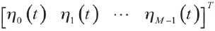
MGISS, a United Kingdom-based geospatial technology company, has launched the Interruption Prevention Alert Service (IPAS) project to help minimize disruptions to gas and water supplies in the UK. The European Space Agency (ESA) has partly funded this project, which will run for two years to test its technical and commercial viability and to develop a go-to-market plan.
As gas and water outages caused by construction are a growing problem in the UK, IPAS will offer a preventative solution. By leveraging satellite data and services, IPAS will automatically detect changes to the built environment and alert utility providers. The IPAS is expected to be a cost-effective solution and help utility providers reduce carbon emissions.
MGISS is collaborating on this project with Geospatial Insight, its data partner, Northumbrian Water Group (NWG) and Northern Gas Networks (NGN), its client partners, and funding partners including the ESA and the UK Space Agency (UKSA).
The launch of the pilot project is the result of a joint workshop with ESA and NWG’s 2020 Innovation Festival, and two years of ongoing collaboration with NWG and NGN.
Image: Vincent Ryan/iStock/Getty Images Plus/Getty Images
“Seen & Heard” is a monthly feature of GPS World magazine, traveling the world to capture interesting and unusual news stories involving the GNSS/PNT industry.
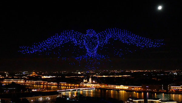
The 10-minute-long drone show included a flying dove with a wingspan of 600 meters, visible from three kilometers away. (Photo: u-blox)
A swarm of bird
A massive swarm of drones created a 10-minute show over Saint Petersburg, Russia, on Sept. 3. The 2,198 miniature UAVs danced for 10 minutes, forming images such as a dove with a wingspan of 600 meters, visible from three kilometers away. Geoscan built and programmed the drones, which use u-blox positioning modules.
Mobile GIS Services (MGISS) is helping the Yorkshire Wildlife Trust (YWT) deploy rugged handhelds to capture highly accurate survey measurements with cloud-based data storage and GIS software. Trust projects include restoring the largest, continuous blanket bog system in England. Blanket bog has been damaged by excessive burning, overgrazing, man-made drainage and extreme weather events. The YWT is using Spectra SP20 handheld GNSS receivers.
Photo: Genni Brookshire/Ceto Marine Research
Drones to the rescue
Seals and sea turtles face threats from humans, such as fishing nets. Marine biologist Genni Brookshire, Ceto Marine Research, and David Thirtyacre, Embry-Riddle Aeronautical University, are researching how drones can improve animal rescue, with help from Skyward, a Verizon Company. Her team is using drones to find and help distressed marine animals. “Using a drone before we respond to an animal to determine the animal’s condition — if it’s entangled, its body condition, if it’s sick — allows us to bring the proper equipment,” Brookshire said. “Using a drone allows us to reduce the stress on the animal, and increase our efficiency in responding to their unique situation.”
Photo: dzphotovideo/E+/Getty Images
Flight mysteries tracked
GNSS tech in a smart altimeter is guiding paragliders, skydivers, wingsuit pilots and other free-flying athletes. Dekunu Technologies’ One SmartAlti body-worn altimeter offers altitude and position information similar to what pilots obtain in their cockpits, increasing safety throughout freefall. Along with a multi-constellation u-blox chip, the device includes Bluetooth, Wi-Fi and USB. A cloud service incorporates 3D visualizations of the user’s jump data.
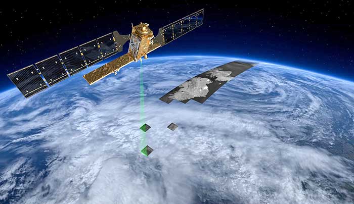
Mobile GIS Services (MGISS) has equipped a team of urban surveyors with new satellite positioning systems to accurately map assets and features such as signage, lighting and landscape features. The technology supplied by MGISS included Leica smart antennas coupled with data management and mapping software.
For this project, MGISS worked with Occam’s Razor Consulting Limited (ORCL), a specialist in data capture for landowners, to achieve centimeter accurate asset mapping for open spaces and park management. ORCL works for local authorities and housing associations and due to the blocking effects of tall buildings and trees, its existing equipment was not capable of achieving the required levels of accuracy, MGISS said.
According to MGISS, ORCL had previously been using the Leica GG03 antennas with Leica rugged tablet computer computers. MGISS then recommended ORCL use the GG04 plus Leica smart antenna. ORCL is now operating its new smart antenna with a Leica controller running Zeno Field (an OEM version of ArcPad 10) software.
According to MGISS, in addition to the ArcPad GIS functionality, Zeno Field provides GNSS raw data logging, easy handling of GNSS configurations, feature accuracy management and an automated workflow between the field and office. ORCL also uses Laser Technology TruPulse rangefinders and Leica Smartnet for its RTK service, all specified and supplied by MGISS. Working with MGISS ORCL will monitor its current workflows as the software develops to support LTI laser rangefinders and will continue to explore new applications, MGISS said.
“We were interested in very high performance equipment capable of achieving centimeter accuracy in difficult urban canyon conditions and under dense tree canopies,” said David Brown, managing director of Occam’s Razor Consulting. “The new MGISS solution has slotted straight into our existing workflows without any issues at all and is a clear improvement on our previous system. The devices track the newer Galileo constellation, as well as the more established American and Russian satellites, reaching centimeter accuracy quickly and holding the signal well overcoming the challenges of tall buildings and trees.”
Mobile GIS Services (MGISS) has been awarded a place on the United Kingdom government’s procurement platform G-Cloud.
Designed to ease the procurement of cloud services by the public sector, the G-Cloud 12 framework makes it easier for customers to find, review and contract MGISS’s advanced geospatial software services through an online digital marketplace. Managed by Crown Commercial Services, it is forecast that successful suppliers, such as MGISS, will receive up to £2 billion in business.
In a parallel achievement, MGISS has also been accredited as a supplier of software, hardware and support services to the utility sector by the supplier assurance company Achilles.
A specialist in mapping and geographic information technology, MGISS also is working alongside organizations such as United Utilities and Northumbrian Water Group and it is hoped that successful qualification under the Achilles UVDB pre-qualification system will help MGISS gain further traction within this sector.
MGISS has also attained the Workplace Wellbeing Charter. Recognizing a commitment to improving the lives of its team members, MGISS received accreditation across a number of facets including leadership, health and safety, mental health and absence management.
“Although recognizing completely different aspects of the business these awards are all significant milestones and accomplishments in their own right and the entire team should be proud of the hard work and commitment they have expended to achieve them,” said MGISS Managing Director and Founder Mike Darracott. “The G-Cloud and Achilles accreditation will put MGISS front and center for the leading players within the public and utility sectors and this will help us capitalise on our work to date with organizations such as Surrey County Council and Wales and West Utilities.
“The Workplace Wellbeing Charter not only recognizes our existing commitment to the health and wellbeing of our team it also gives a benchmark to work from and a toolset to work with to continuously improve,” he continued, “and a happier and healthier workforce will, we hope, make the business even better and stronger.”
Mobile GIS Services (MGISS) is working with the European Space Agency (ESA) to showcase the potential of satellite positioning systems and imagery in tackling some of the environmental and societal challenges being faced by the water industry.
The two organizations joined together to develop multimedia experiences, group exercises and real-world case studies, which will be shared at the Northumbrian Water Innovation Festival, taking place Sept. 15.
The four-day festival, which has attracted more than 6,500 visitors across previous events, will take place virtually from Sept. 14-17.
“Under the theme ‘We Need Space to Innovate,’ we are aiming to explore how we can use satellite services to improve asset management for organizations such as Northumbrian Water, alongside the wider water and critical infrastructure sectors,” said Mike Darracott, MGISS managing director.
A highlight of the organizations’ participation will their Daily Dashes. The Daily Dashes will be rapid, sprint-style workshops that run through all stages of the subject and include music, video, live demonstration and hands-on workshops to explore specific topics relevant to the water industry. According to MGISS and ESA, the Daily Dashes will provide a better understanding of how satellite services can be used to improve asset insight and operational performance.
“Satellite positioning systems are extensively used for asset location, and yet do users really understand the full array of technology on offer or the additional potential that can be derived from earth observation data?” Asked Alan Cross, regional ambassador for ESA. “By working with MGISS, we will demonstrate how improved positioning and asset insight has the potential to deliver benefits for operational resilience, improved safety and higher productivity.”
GPS World’s November 2020 issue will focus on water applications, so stay tuned for that issue.
MGISS, a U.K. geospatial specialist, has released a new version of its web app TopoGrafi that allows for the display of 3D data in real-world models. With enhanced 3D data processing capabilities, TopoGrafi is an end-to-end platform for capturing buried asset data and processing it for augmented reality visualizations.
Aimed at the utility and infrastructure sectors, TopoGrafi is helping organizations in water and highway sectors enhance asset location data, improve on-site safety and reduce construction and maintenance costs.
Designed to be used alongside apps such as Esri Collector for ArcGIS, the TopoGrafi platform uses GNSS data.
It applies near-real-time conversions, transforming the recorded positions to local reference systems and aligning it with high-accuracy mapping including Ordnance Survey MasterMap.
The TopoGrafi toolkit also includes functionality to “snap” 3D features to each other and to other spatially referenced data, in order to create a true 3D model that can then be used to create Augmented Reality visualizations accessible from the desktop or in the field.
The development of augmented reality as a tool to manage and visualize hidden infrastructure assets has taken a major step forward following the announcement of a partnership between two technology companies.
MGISS, a U.K. geospatial specialist, has partnered with Canada-based vGIS to transform traditional GIS, BIM and CAD data into stunning augmented-reality visualizations.
Augmented reality provides an interactive experience of an environment where objects that reside in the real world, such as underground pipes, are displayed and enhanced with additional intelligence such as attribute information and maintenance records.
A specialist in the use of geospatial technology in the utility, infrastructure and environment sectors, MGISS said it understands the demands for improved spatial data quality and the requirement to communicate complex, asset dense, 3D environments in an easy-to-consume way.
Photo: MGISS
By combining authoritative survey-grade positions and associated data with consumer-grade hardware MGISS enables users of vGIS to access augmented reality visualizations from any suitable smart device.
vGIS is the leading augmented and mixed reality visualization technology for GIS data. Using the vGIS system, field personnel can see an augmented view that includes holographic infrastructure objects, improving environmental assessments and increasing situational awareness.
“Initiatives such as digital twinning and the expectation of ‘business as usual’ operations require the capture and representation of increasing complex real-world environments. Asset owners and operators face a number of challenges and opportunities including the need to improve safety, reduce risk and ensure what lies beneath our feet meets future infrastructure needs,” said Mike Darracott, managing director and founder of MGISS.
“vGIS truly understand the needs and the challenges facing these sectors. In fact, vGIS goes further than any other Augmented Reality solution by providing a full range of 3D spatial data capabilities; all within a platform that works with existing enterprise systems and data structures,” added Darracott.
“Value is often hidden deep within the structure of data. By helping people ‘see’ data in more intuitive ways, they gain new insights and can subsequently do more with that information. That’s been the core operating philosophy of vGIS,” said Alec Pestov, founder and CEO of Canada based vGIS. “To achieve this we are building an ecosystem bringing together top experts to work jointly towards a common goal. MGISS possesses deep expertise in the spatial services and solutions sector and we are looking forward to joining forces to deliver augmented and mixed reality visualizations in the UK.”