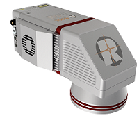
AllTerra, a Trimble geospatial dealer, has joined the GeoCue distribution network. AllTerra will provide GeoCue’s full line of TrueView 3D imaging sensors, a UAV, lidar and photogrammetry solution. The technology enables fast, automated generation of true 3D colorized point clouds, oblique imagery and orthophotos from a single UAV flight.
AllTerra is also authorized to sell LP360 lidar and photogrammetry 3D point cloud software. LP360, an advanced desktop lidar software package, simplifies extracting information and generating deliverables in a GIS environment.
The company offers Trimble and Spectra Precision solutions in surveying, MGIS, marine, forensics, mobile mapping and infrastructure. Alltera also offers mobile/airborne lidar and photogrammetry solutions from GeoCue and Microdrones.
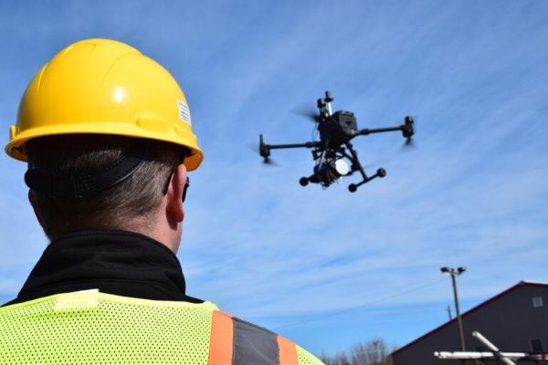
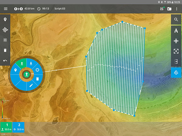
The mdCockpit app from Microdrones was designed for professional drone users to make it easy to plan, monitor, change and control flights from an Android tablet.
The latest updates — in mdCockpit 2021.3 — include new features that improve flight safety and give more options for surveying in an aim to deliver a premier solution for planning, monitoring, adjusting, analyzing and controlling professional drone flight missions right from a tablet. Robert Chrismon, the marketing manager, and Maude Morin, Software Product Owner discuss the updates in the video below.
Key updates for mdCockpit version 2021.3 are in the Flight Editor, Flight Data and Drone Configuration components of the app.
FLIGHT EDITOR
New layers section in Mission Dashboard
KML as a background layer
Optimized entry point on corridors
FLIGHT DATA
Displays last position of the drone
Drop renamed to Descent in Quick Height Change dialog
Telemetry alerts
DRONE CONFIGURATION
New maintenance program fields in drone config
Reminder of the next inspection or service
Read only homing height
Drone pilots can download mdCockpit onto their Android table through the Google Play store.
A roundup of recent products in the GNSS and inertial positioning industry from the April 2021 issue of GPS World magazine.
OEM
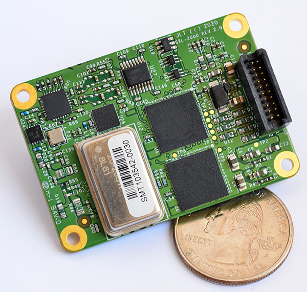
STL receiver
For Satellite Timing and Location service
Photo: JLT
The STL-2600 Satellite Timing and Location (STL) commercial receiver was designed in partnership with Satelles Inc., the STL service provider. The STL-2600 provides a GNSS-independent, low-cost capability to generate UTC nanosecond timing and meters-accurate positioning anywhere in the world. The STL signal has 30-db (1,000 times) higher power compared to GPS signals, allowing the receiver to operate deep indoors independent of any GPS/GNSS signal. It is also useful in marine applications where GNSS signals are regularly denied or manipulated and for stationary high-accuracy timing applications such as 5G. It can be directly connected to JLT’s GPS Transcoder products for glueless retrofit capability of existing customer legacy GPS-only receiver systems to Galileo, GLONASS, BeiDou, QZSS and SBAS as well as adding the STL and optional atomic holdover capability to these legacy systems.
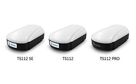
The TS112 family of smart antennas is designed for demanding applications such as agricultural machine autosteering systems that require high positioning accuracy. They offer scalable positioning solutions with increased GNSS availability, reliability and accuracy. Each of the three models embeds Harxon X-Survey four-in-one technology. The high-gain and wide beamwidth multi-constellation GNSS antennas integrate 4G, Bluetooth and Wi-Fi in a compact unit. They feature multi-point feeding technology, ensuring high phase-center stability and real-time kinematic (RTK) centimeter-level positioning accuracy. They integrate a high-precision GNSS module with multi-band GNSS receiver and Harxon’s four-in-one multifunctional GNSS antenna in a compact housing.
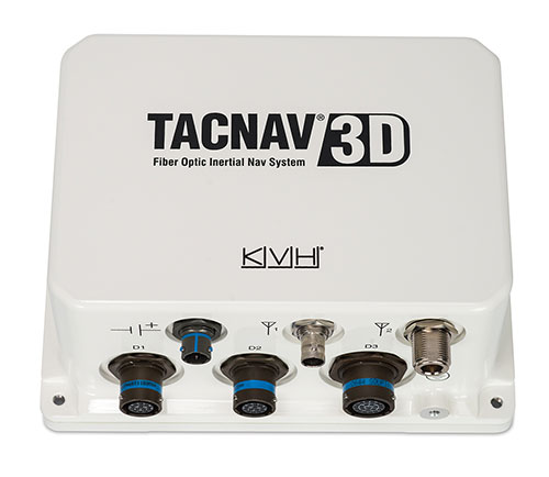
The TACNAV 3D tactical navigation system is now available with the P-1775 inertial measurement unit (IMU) featuring KVH’s new photonic integrated chip (PIC) technology. PIC technology features an integrated planar optical chip that replaces individual fiber-optic components to simplify production while maintaining or improving accuracy and performance. KVH’s IMUs with PIC technology are designed to deliver improved bias stability and greater accuracy. The fiber-optic gyro (FOG)-based TACNAV 3D tactical navigation system provides an assured positioning, navigation and timing (A-PNT) solution with an embedded GNSS and optional chip-scale atomic clock (CSAC).
IoTeX has selected Nordic Semiconductor’s nRF9160 low-power System-in-Package (SiP) with integrated LTE-M/NB-IoT modem and GPS receiver to provide the cellular internet of things (IoT) connectivity for its Pebble Tracker. The Pebble Tracker provides trusted location, environment and motion-tracking data for global asset tracking and industrial supply chain applications. Critical features strengthen security from hacking and data corruption, meeting the demand of applications that require strong data security and integrity protection throughout the supply chain. There are two versions of Pebble Tracker. The first targets blockchain and IoT developers, while a second commercial version is designed for the asset tracking and industrial supply chain markets. The product combines an environmental sensor, a motion sensor (gyroscope and accelerometer), and an ambient light sensor. It enables cellular network connectivity and integrated GPS support in a global version supporting precise, long-range tracking of asset data using established cellular infrastructure.
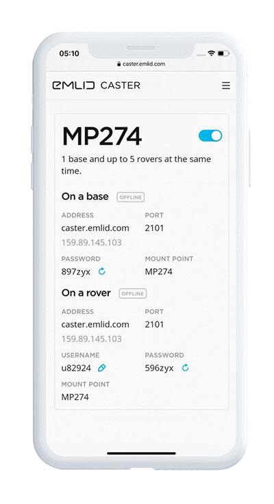
Enables transmission of corrections via the internet
Emlid Caster is an easy way to transmit corrections between real-time kinematic (RTK)-capable devices via the internet. Emlid Caster has a simple interface. Users can create their personal mount point and connect one base and up to five rovers. It works not only with Emlid products but any other device supporting NTRIP. For example, users can pass RTK corrections to the DJI Phantom 4 RTK drone from the Reach RS2 receiver as a base station. Emlid Caster is free and available worldwide. Once signed up, personal NTRIP credentials are generated automatically for a base and a rover.
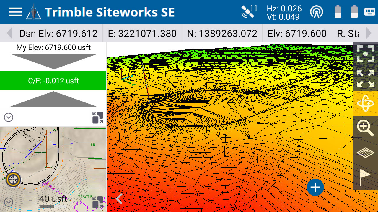
The Trimble Siteworks SE Starter Edition. (Screenshot: Trimble)
The Trimble Siteworks SE Starter Edition is an entry-level construction surveying software program. With the program and a construction GNSS receiver, a supervisor, foreman, grade checker or site engineer can easily check a grade, slope or alignment and navigate the project more accurately and in less time than with traditional survey methods. It also can give more personnel on the jobsite access to survey technology, enabling more productive and efficient field crews. Trimble Siteworks SE Software is a simplified version of Trimble Siteworks Software, intended for users who do not require a full feature set and are interested in a lower-cost version to connect to GNSS only. Contractors can easily upgrade to the full version.
The Leica CityMapper-2L configuration is designed for airborne urban mapping projects at low altitude operation. Lower flying heights can be required by air traffic control (ATC) restrictions and in areas with low cloud cover. It features a 71-mm focal length at nadir, suitable for 5-cm ground sample distance (GSD) data acquisition at flying heights of 940-m above ground level. The new lenses offer similar coverage and productivity for a specific GSD as existing configurations for standard and high-flying heights, while significantly expanding the operation envelope. The CityMapper-2 hybrid airborne sensor combines oblique imaging and a lidar in one system. The sensor efficiently creates digital twins of cities. The system includes two 150 MP nadir cameras (RGB and NIR), four 150 MP oblique cameras and a 2-MHz linear-mode lidar sensor.
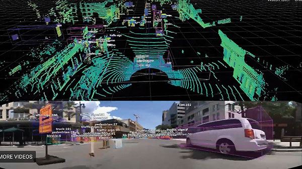
Full-waveform flash data for autonomous vehicle development
Photo: LeddarTech
Leddar PixSet is a publicly available sensor dataset for advanced driver assistance and autonomous driving research and development. The dataset includes full-waveform data from LeddarTech’s Leddar Pixell, a 3D solid-state flash lidar sensor. LeddarTech is offering these datasets free of charge for academic and research purposes. It allows academic and engineering research teams specializing in advanced driver-assistance systems (ADAS) and autonomous driving technology to use existing sets of sensor data to test and develop advanced software and to run simulations without having to assemble new sensor suites and collect their own dataset. An instrumented vehicle was utilized in the development of the dataset. The various scenes were recorded in high-density urban and suburban environments as well as on the highway.
The mdLiDAR1000HR aaS drone lidar survey package is designed for professionals responsible for geospatial data collection, such as corridor mapping, mining (volume calculation), construction site monitoring, recording environmental changes over time, forestry, contour mapping, archaeology and cultural heritage, and more. The drone lidar system has a 90° field of view for both scanned points and imagery. It repeatedly provides a precision of 1.6 cm (.052 feet) when flown at 40 m (130 ft) at a speed of 8 m/s (18 mph). It integrates the Velodyne Puck Lite lidar sensor.
The fixed-wing eBee Ag drone can provide a complete assessment of a farm and crops faster than traditional field scouting. With its dual-purpose Duet M camera, eBee Ag captures accurate RGB and multispectral data that enable farmers to effectively assess crop health and help catch early indicators of pests, diseases and weed infestations that threaten crop yields. It features real-time kinematic (RTK) functionality for greater mapping precision. With its available RTK, the drone can achieve absolute accuracy down to 2.5 cm (1.0 inches) with RGB. Highly accurate index maps allow farmers to understand each acre while managing problematic areas field-wide.
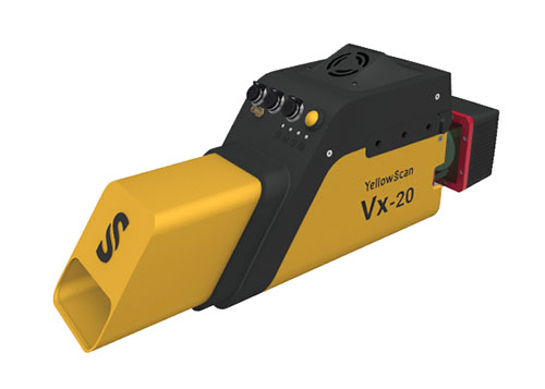
The Vx15-300 and Vx20-300 UAV lidar solutions are new additions to Yellowscan’s Vx product series. A new terrain software module allows users to automatically classify grounds from off-ground, as well as export various digital elevation models. Both integrate the Riegl Mini-VUX 3 airborne laser scanner (1.55 kg / 3.4 lbs), designed specifically for integration with UAVs. The scanner offers a selectable 100-kHz, 200-kHz and 300-kHz laser-pulse repetition rate (PRR). At 300-kHz PRR, the sensor provides up to 100,000 measurements per second at 120° field of view, and thus a dense point pattern on the ground for UAV-based applications that require the acquisition of small objects.
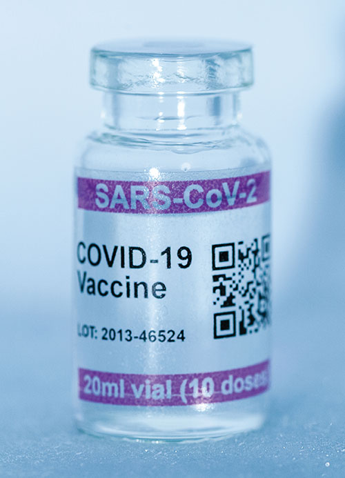
Cryo-Vacc containers use helium — a fraction of the weight of nitrogen — to provide safe transportation of vaccines at the required extremely low temperatures and for periods of up to 30 days, without the need for any power supply. Now in prototype, the containers work with both air and ground transportation. A temperature range of -150°C to 8°C, makes it versatile for a range of vaccines — including those for COVID-19 — that need to be transported for up to 25 days or longer in transit, where access to an external power source is not possible. Combined with cold-chain monitoring and asset tracking technology from Beyond Wireless (a World Health Organization-certified provider), Cryo-Vacc can provide accurate temperature readings of vaccines in transit, as well as GPS-based tracking to ensure the custody chain can be audited.
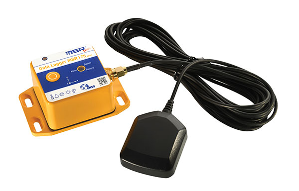
The tamper-proof MSR175plus GPS data logger records potentially damaging shock events as well as the associated ambient conditions with the exact geographic position via its GPS/GNSS receiver. It contains two 3-axis-acceleration sensors (±15 g/±200 g), a temperature sensor (-20 to +65° C), a humidity sensor (0 to 100% relative humidity), air pressure sensing (0 to 2000 mbar), and an ambient light sensor (0 to 65,000 lux). It helps ensure compliance with transport specifications and provides irrefutable data for identifying damage liability for help with insurance claims. An external connector is ready for a cable-connected antenna. The removable, rechargeable 2400 mAh LiPo-battery enables recording for up to 8 weeks (at least one year without GPS-based tracking).
When Trimble sold its Gatewing fixed-wing drone business to Delair in October 2016, its decision was based on several drivers. Trimble had worked with Delair since 2008 and knew their capabilities; the company decided that a dedicated drone company should be better placed than a GNSS manufacturer to find and develop leading-edge drone business. Also, the sale enabled Trimble to better focus on integrated UAS software technology for positioning, remote sensing and photogrammetry. Delair joined up with Microdrones, a supplier of multi-rotor UAVs, to round out the team’s offerings. Both companies are skilled in the application of Trimble UAV software.
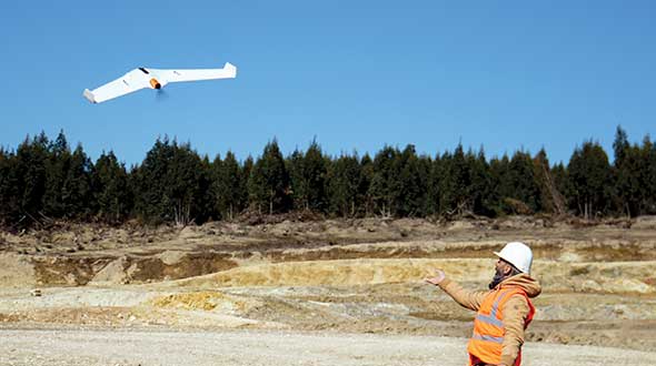
Typical Delair drone applications include rapid data gathering using the UX11 fixed-wing drone, followed by data analysis leading to highly accurate survey-grade results.
For the Johnson Poole and Bloomer (JPB) mine sites, personnel safety was an important driver in moving away from having people on the ground collect data, sometimes in dangerous situations. Time and cost savings have now become the norm for JPB survey operations, particularly for stockpile volume calculations.
With the UX11 flying at 400 feet for 40–45 minutes, up to five times each day, it is possible to collect thousands of photos of many acres — ending with an accuracy of around 1.7 centimeters.
The UX11 drone is equipped with a high-precision Septentrio AsteRx-m2, providing post-processed kinematic (PPK) multi-frequency, four-constellation signal reception. The AsteRx-m2 is also low power and low weight.
Another mining operation using Delair drone survey and analysis tools is Luck Stone in Virginia. With numerous quarries in Maryland and Virginia, Luck Stone produces aggregates and more than 75 crushed stone, sand and gravel products for civil engineering, private construction and environmental projects. Luck Stone also finds that inspection staff safety is significantly improved, as is the time for such inspections, and asset inventories are not only accurate but also can be undertaken quickly and much more often.
Delair has just released a new agriculture system with the fixed-wing Delair UX11 Ag, along with the Delair Aerial Intelligence (delair.ai) processing system. An integrated and easy-to-use workflow has been developed to collect, manage, analyze and share agriculture data for crop health monitoring, field experimentation analysis, automatic machine guidance, precision ag practices and better crop traceability.
The new system makes use of PPK for precise auto-geolocation. The UX11 Ag drone carries a fully integrated high-grade multispectral camera for the data collection and monitoring of plant health.
Delair.ai supports tools that provide visual field maps, identifying plant health by chlorophyll content, green biomass, stoutness/visual health and other plant indicators. The drone enables spray prescription preparation to counter weeds, disease and pest infiltration. UAVs also make it possible to determine the effectiveness of treatment regimes.
In addition, Delair has developed the DT26 fixed-wing series of longer range drones for two-hour lidar survey flights and for surveillance; it can be adapted to carry other customer payloads. The DT26 uses an Applanix/Trimble GNSS receiver.
Delair customers also use their drones for power-line inspections and in the oil and gas industry for site preparation surveys and pipeline inspections. The UX11 was the first drone from a Trimble partner to provide a JXL file for processing UX11 data in the Trimble Business Center.
As part of ongoing global expansion, Microdrones has merged with Schübeler Technologies. Since its founding in 1997, Schübeler has built a global business by providing advanced fan propulsion jets and lightweight composite materials fabrication.
Offering a full product lineup of robust turbo fans, jets, compressors, pumps, electric motors, carbon fiber and aluminum composites, Schübeler products are designed to withstand extreme conditions and demanding field use. These components provide thrust power and lightweight durability to high-tech applications including UAVs, professional motorsports and heavy-duty outdoor equipment.
Microdrones, founded in 2005, has evolved from a manufacturer of commercial-grade unmanned VTOL aircraft to a provider of fully integrated systems for surveying, mapping, lidar and inspection applications. These systems are being put to use worldwide by professionals in the construction, mining, energy, agriculture and infrastructure trades.
“We make life easier for professionals by offering the full solution; it has proven to be a successful strategy,” said Microdrones President Vivien Heriard-Dubreuil. “Perfectly integrated drones, sensors, software, workflow, training and support is what the market needed. Welcoming the Schübeler team, talent and capabilities to Microdrones delivers new aviation technology and capabilities to our customers in the form of next generation unmanned aircraft.”
As the preferred provider of VTOL solutions to Trimble Dealers worldwide, Microdrones adds a global sales force and distribution network as well as technical centers and production sites spanning seven countries and three continents.
“Merging with Microdrones empowers us to develop and deliver systems where we can best support customers locally,” said Daniel Schübeler, founder and CEO of Schübeler Technologies. “This is a happy homecoming for me and the team that we’ve built over the past 20 years.”
Schübeler was an original founding partner in Microdrones and helped develop the pioneering technology that helped Microdrones gain global recognition for professional VTOL UAVs. He adds, “Both of these companies have enjoyed global growth and impressive technological advancements independently. Merging our talents and teams will yield amazing solutions in the years to come.”
“This is a strategic growth initiative,” explained Francois Gerner, SVP of Corporate Affairs at Microdrones. We are adding technology, IP, talent, strong leadership and investment capabilities that are complementary to both brands. This deal brings us to more than 150 highly skilled employees worldwide, which translates to better products, service and support.”
The merged companies will retain the Schübeler Technologies brand, which commands a niche’ audience of serious aeromodeling enthusiasts. Schübeler Technologies will continue to serve these markets as well as tackle large-scale custom R&D projects related to propulsion and materials.
In Halle, Germany, Microdrones worked with construction company Strabag to fly the mdMapper1000DG above Highway A33 to create a point cloud and orthophoto of a 12-kilometer stretch of the Autobahn.
The drone was equipped with special transponders to make it visible to German Air Traffic Control, enabling beyond-visual-line-of-sight (BVLOS) flight. BVLOS allows for longer flights that cover more area and capture more data.
Using the drone for corridor mapping of the Autobahn enables closer inspection and visualization of the highway to find pavement imperfections, road wear and tear, and other potential safety hazards, Microdrones said.
The Commercial UAV Expo takes place Oct. 1-3 at the Westgate in Las Vegas. The expo brings together more than 3,000 professionals, and provides both education and an exhibit floor filled with high-precision UAS technology.
LidarUSA showcases revolutionary tech.LidarUSA will be at Booth 515, discussing its lidar products and the impact of the technology on the UAV industry.
“Whether you’re documenting a road accident scene at night, designing rice field irrigation systems or surveying archeological sites under dense forest canopies, advances in 3D mapping and geospatial data capturing are making these once time-consuming tasks, quicker and more efficient than ever before,” the company explains.
Pilot a WingtraOne. Wingtra, in collaboration with RDO Equipment Co., will be attending Commercial UAV Expo, North America’s trade show and conference for the commercial drone market.
Wingtra will be demonstrating its WingtraOne drone on Wednesday, Oct. 3, at the William Bennet R/C Airfield. The demonstrations begin at 8 a.m., with hotel pick-up provided at 7:30 a.m.
Register here for the demo, or visit Wingtra’s booth is 1404 in the Westgate.
RIEGL exhibits sensors, systems.RIEGL will be exhibiting at Booth 309 during the conference, showcasing its unmanned sensors and systems as well as the miniVUX-1UAV.
The miniVUX-1UAV is integrated onto a DJI-M600 with the RIEGL Integration Kit 600. It is a user-friendly, cost-efficient miniaturized lidar sensor for unmanned laser scanning to acquire survey-grade measurement data through the use of remotely piloted multi-rotor, rotary-wing or fixed-wing UAVs for a variety of applications.
The miniVUX-1DL. (Photo: Riegl)
The miniVUX-1DL is a downward-looking lidar sensor for unmanned laser scanning with a special design tailored to meet the needs of corridor mapping tasks through its downward looking capability, its optimized field of view, and its small size.
Microdrones offers post-show event.Microdrones, which offered a series of workshops during the expo, is providing an in-depth technical symposium following its conclusion. The Key presenter is Mohamed Mostafa, director of mdSolutions at Microdrones.
On Oct. 4, expo attendees are invited to join ASPRS for an additional in-depth technical symposium led by Mostafa. Registration at the Commercial UAV Expo is required and the ASPRS UAS Symposium is an optional add-on event.
The symposium features detailed technical discussions on high-precision mapping by drones including lidar, photogrammetry, GNSS, inertial, datums, post processing, best practices and quality control. Real-world datasets acquired in the U.S. and Canada will be used to demonstrate the concepts and best practice of precision mapping by drones.
Other presenters at the symposium are:
Karen Schuckman, PLS, CP, CMS, Pennsylvania State University
Pergam gas sensor aboard the Microdrones md4-1000 UAV.
The professional aerial methane detector mdTector1000 CH4 from Microdrones makes it easy to detect methane gas via a fully integrated aerial package for professionals responsible for methane gas infrastructure.
The mdTector1000 CH4 has a Pergam gas sensor, mounted and integrated with the Microdrones md4-1000 UAV. In real time, users can see aerial shots of detection with the laser sensor, the company said. The carbon-fiber built UAV goes into dangerous areas unsuitable for workers.
The mdTector1000 CH4 can be used for natural gas line surveys, tank inspections, gas well testing, plant safety and landfill emission monitoring.
The mdCockpit Android App allows users to maintain visualization in flight. A special mdTector app allows users to visualize and present all post-flight data on one map.
Microdrones collaborated last summer with the DLRG Horneburg/Altes Land e.V. (German Lifeguard Association) to simulate a mission to rescue a drowning swimmer, demonstrating the life-saving potential of UAVs.
Crowds watched from the banks of the Elbe River as a UAV flew to the person in distress and dropped a compact rescue device called RESTUBE, which automatically inflated. The swimmer was able to grab onto the RESTUBE and float until he could be reached by a lifeguard and brought to safety.
The UAV used in the rescue was the microdrones md4-1000. The quadcopter drone features specially developed motors, carbon fiber housing, efficient batteries, and an integrated GPS system that allow the UAV to fly and stay in position in strong winds over the water.
For the simulation, the md4-1000 was equipped with an imaging camera that streamed live to the specially trained lifeguard operating the drone, allowing him to easily see the precise location to drop the RESTUBE flotation device.
“An adult drowns in approximately 60 seconds and a child in only 30,” said Christopher Fuhrhop, founder and CEO of RESTUBE. “By combining UAVs and RESTUBE flotation devices, we arE able to buy the drowning person valuable time that could very well mean the difference between life and death.”
Other safety possibilities for quadcopters include locating people using thermal imaging cameras and collecting data on the condition of leaking and burst banks on hard-to-reach embankments.
Strategic alliances with Delair-Tech and Microdrones expand UAS platform options while leveraging Trimble software and data solutions.
Delair-Tech has acquired Trimble’s Belgium-based Gatewing unmanned aircraft system (UAS) engineering and manufacturing business.
Delair-Tech is a provider of long-range, fixed-wing UAS solutions for industrial inspection and asset management applications headquartered in Toulouse, France. Delair-Tech intends to grow the acquired business as part of its portfolio, according to a joint press release with Trimble. Financial terms were not disclosed.
“This transaction is part of our continuing program to tighten our corporate focus,” said Ron Bisio, vice president of Trimble’s Geospatial Division. “Trimble will remain actively engaged in the market by leveraging its brand-agnostic software technology for a broader range of UAS platforms.”
Gatewing has been reported as part of Trimble’s Engineering and Construction segment. The divestiture will not have a material impact on either overall or segment financial results.
Strategic Alliances Expand UAS Options. In addition, Trimble has entered into strategic alliances with Delair-Tech and Microdrones of Siegen, Germany. Microdrones is a provider of multi-rotor UAS solutions.
Under the agreements, Delair-Tech and Microdrones will become preferred providers of both fixed-wing and multi-rotor UAS solutions, with Trimble providing software, data processing and deliverables to UAS operators across multiple vertical markets.
“Trimble chose to partner with Delair-Tech and Microdrones to strengthen our UAS portfolio,” said Bisio. “Working together, Delair-Tech and Microdrones will deliver industry-leading UAS platforms and Trimble will focus on core software technology for UAS that integrates positioning, remote sensing and photogrammetry. The end goal is to deliver a complete solution to transform work processes and efficiency for our customers.”
“We are proud that Trimble selected us to be their fixed-wing UAS solution provider. With the addition of Gatewing to our portfolio, we can provide one of the most innovative and extensive portfolios of long-range, fixed-wing commercial UAS solutions to support Trimble and its distributors,” said Michael Delagarde, CEO of Delair-Tech. “The portfolio will continue to provide dedicated end-to-end solutions, from hardware to fully processed aerial data, which can then be turned into actionable business intelligence.”
“Microdrones complement the Delair-Tech fixed-wing lineup with one of the most resilient and stable Vertical Take-off and Landing (VTOL) aircraft on the market today. This provides a complete product line of tightly integrated solutions for mapping,” said Microdrone’s president, Vivien Heriard Dubreuil. “We’re excited to support Trimble distributors to enable a one-stop shop for UAS mapping solutions and to enable their global customers to produce exceptional results on every job.”