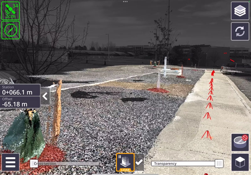
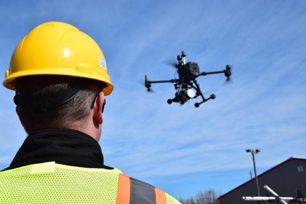
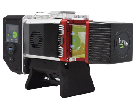
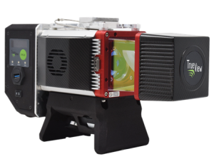
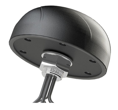
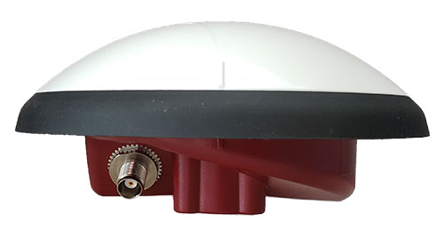
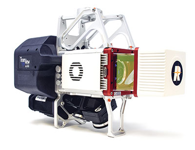
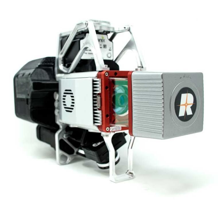
GeoCue has announced the upcoming release of the TrueView GO NEO, a handheld SLAM lidar system that expands the company’s TrueView handheld lidar product lineup.
Unveiled at Geo Week 2026 in Denver, The TrueView GO NEO adds a smaller, lighter, more portable option designed to make handheld mapping easier, more flexible, and more affordable, especially for indoor capture. It pairs with a smartphone, keeping the workflow streamlined and the total cost of ownership low.
Since introducing the original TrueView GO 116S and TrueView GO 132S handheld systems, GeoCue has seen rapid adoption of handheld mapping workflows across surveying, construction, public safety, facility documentation, and more. The new TrueView GO NEO extends that momentum with a rugged design and high performance for teams who need dense data and dependable SLAM in corridors, stairwells, mechanical rooms, and other GNSS-challenged environments.
Indoor mapping
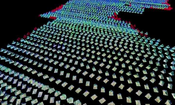
The TrueView GO NEO was designed as a complete, end-to-end workflow, helping teams move quickly from data acquisition to usable results in complex indoor environments. At its core is a new high-rate scanning engine capable of capturing up to 1.15 million points per second, delivering dense detail while improving field efficiency. An ultra-wide field of view (360° × 189°) increases coverage overhead and helps reduce missed areas, so users can capture complete scenes faster without “painting” every surface.
The NEO also introduces Deep INS + SLAM Fusion, pairing SLAM mapping with a high-grade inertial navigation system to improve stability in feature-poor environments where typical consumer-grade navigation can struggle. The result is more reliable trajectories and improved point cloud integrity in challenging scenarios, such as long corridors and multi-floor stairwells, where drift and misalignment can degrade results.
To enhance interpretation and deliverables, the TrueView GO NEO includes HD colorization and advanced image capture to support panoramic imagery and detailed colorization even in low light. Users can also leverage these images to create visual outputs such as mesh models and high-fidelity reality renderings for downstream documentation and visualization workflows.
Paired with LP360 Land
TrueView GO NEO is paired with LP360 Land, GeoCue’s software for handheld lidar processing, QA/QC, visualization and deliverable creation. LP360 Land enables users to generate detailed point clouds from raw data, validate coverage and quality, and produce outputs aligned to project workflows without unnecessary complexity.
The NEO is also designed to keep workflows streamlined, pairing conveniently with a phone and supporting device-to-cloud options through the LP360 Cloud platform. Users can upload captured data over Wi-Fi or hotspot for automated post-processing or use an LTE-based workflow to upload data.
Highlights
Smaller, lighter handheld SLAM lidar designed to “complete the range” of the TrueView GO lineup
High-speed point capture for fast, dense indoor reality capture
Ultra-wide field-of-view scanning to improve coverage and reduce blind zones
Precision IMU for low-drift SLAM, supporting reliable results over longer sessions even in typical SLAM challenging conditions
Integrated HD imaging for spherical capture and high quality colorization
Built-in GNSS for georeferencing workflows when GNSS is available (RTK/PPK capable)
“Smart Handle” integrating the battery with hot-swap battery capability for continuous scanning
Read a roundup of recent products in the GNSS and inertial positioning industry from the March 2025 issue of GPS World magazine.
Surveying and Mapping
Photo: Eos Positioning Systems
New Eco-Friendly Carrying Case For Eos Positioning Systems’ receivers
The Skadi Gold, Skadi 300 and Skadi 200 GNSS receivers will now be shipped in a field-rugged carrying case made entirely from recycled materials. The case is designed to meet the demands of professionals who utilize GNSS technology in challenging environments. Its construction incorporates durable, eco-friendly materials that can withstand various field conditions, from remote wilderness areas to urban construction sites.
A key feature is its composition of 100% post-consumer recycled resin, which significantly reduces waste and promotes environmental sustainability, according to the company. It is specifically engineered to be shock-resistant and weatherproof.The case is provided as a standard inclusion with every purchase of the Skadi Gold, Skadi 300 or Skadi 200 GNSS receivers at no additional cost.
Multibeam Sonar Designed for bathymetric surveying
The Gemini 1200id is built on the same robust platform as the Gemini 720is multibeam sonar. The device features a 120° horizontal field of view, operating at both 720 kHz and 1,200 kHz acoustic frequencies.
The Gemini 1200id incorporates advanced noise reduction technology to significantly improve the attenuation of waterborne electrical noise to enhance imaging performance. An integrated speed-of-sound sensor ensures high positional accuracy of displayed targets, while CHIRP processing technology enhances target separation over extended ranges.
Compatibility with Tritech’s Genesis software package allows users to control multiple Tritech products from a single interface to streamline operations. The company has also made software development kits available for Windows and Linux operating systems to integrate into various platforms. The sonar’s design includes a custom-developed analog front-end solution with fully differential receiver channels, making it ideal for longer-range applications.
HiPer XRa is a GNSS receiver for surveying, mapping and construction applications. It can benefit a wide variety of users, including construction professionals, surveyors, geographic information systems (GIS) professionals, archeologists, engineering firms and more. The HiPer XR supports GPS, GLONASS, Galileo, BeiDou, IRNSS, QZSS and SBAS.
The new receiver has advanced Topcon Integrated Leveling Technology (TILT) compensation, featuring a calibration-free and magnetic interference-immune integrated IMU that provides up to 60° of tilt for precision measurements in challenging positions. It has signal integrity protection, anti-jamming and anti-spoofing capabilities. Through the myTopcon NOW! website, users can access online training materials, firmware updates and additional software resources.
Airborne Lidar System Ideal for coastline and river surveying
CoastalMapper is an airborne bathymetric lidar system for coastline and river surveying. The CoastalMapper can survey coastlines and rivers 250% faster than previous sensor models, according to Leica Geosystems.
It is suitable for various mapping applications, from assessing infrastructure resilience to monitoring river floods and conducting environmental investigations.
It features a high-performance bathymetric lidar module, a Leica TerrainMapper-3 topographic lidar and an imaging sensor, integrated into a compact and lightweight sensor head. This allows the CoastalMapper to capture up to 1 million bathymetric data points and 2 million topographic data points per second while providing high-resolution imagery with a 5-cm ground sampling distance at typical flying heights.
It integrates with Leica Geosystems’ airborne mapping workflows and offers cluster processing capabilities, allowing users to analyze large datasets and reduce the time from data collection to final deliverables. These outputs can include classified point clouds, digital terrain and surface models, and various imaging products.
Surveying Kit Streamlines base station and checkpoint setup
WingtraGROUND, a comprehensive survey kit, streamlines base station and checkpoint setup for on-site post-processing kinematic surveys with the WingtraONE Gen II, a vertical takeoff and landing UAV. The kit combines receivers, checkpoints and tools into a single, portable workflow.
The system integrates hardware components with a Wingtra tablet interface, which can help surveyors confirm correct receiver placement and avoid common errors associated with improper base station setup and inaccurate coordinates.
Wingtra receivers, equipped with Emlid Reach RS3 technology, provide accuracy within 2 cm, meeting high standards for aerial data validation. These receivers can also function independently for terrestrial surveys in real-time kinematic mode, including point collection and stakeout for various applications.
Galileo HAS-Enabled Receiver Offers positioning capabilities with 20 cm accuracy
The Geode GNS3H supports Galileo High Accuracy Service (HAS). It offers positioning capabilities with 20 cm accuracy worldwide without requiring additional infrastructure or subscriptions.
It is built to withstand tough conditions, making it ideal for demanding fieldwork. The device offers various accessories, including the Geode Grip, which combines the Geode with a data collection device of choice into a single handheld solution. A backpack strap kit and survey pole are also available to enhance mobility and flexibility in the field. The GNS3H can be used for surveying, agriculture, construction, forestry, mining and archaeology.
Expanded Mapping Portfolio 3D mapping technologies and more
Topcon Positioning Systems has become an authorized distributor of Pix4D’s photogrammetry software portfolio.
The partnership aims to enhance reality capture solutions across various industries, including surveying, mapping, utilities infrastructure, public safety, forensics, and architecture, engineering and construction.
The agreement streamlines the procurement process for end users by allowing them to access Pix4D’s advanced photogrammetry software solutions through Topcon’s global distribution network.
The GNSS real-time kinematic (RTK) 5 Click — a compact add-on board for high-precision positioning and navigation demands — features the UM980, an all-constellation multifrequency RTK positioning module from Unicore, with the advanced NebulasIV SoC for enhanced performance.
It supports Swift Navigation’s Skylark precise positioning service, multiple GNSS constellations and RTK positioning for centimeter-level accuracy. The board also features JamShield technology for robust performance in challenging environments, USB connectivity for easy configuration and visual status indicators for module status and GNSS signal reception.
It can be used for a variety of applications, including surveying and mapping, precision agriculture, UAVs, autonomous robots and autonomous driving.
Multi-Band GNSS Antenna Can operate in urban environments
Levity Series’ AHP24510 (L1/L2/L-Band) and AHP54510 (L1/L5/L-Band) directional patch antennas are designed to receive signals from GPS, Galileo, GLONASS and BeiDou satellite constellations.
These antennas offer faster and more accurate signal acquisition and lock, specifically in urban environments. The L-Band capability allows compatibility with high-precision GNSS correction services. The multi-band antennas offer integral redundancy to minimize satellite security blind spots and reduce energy consumption due to faster acquisition, requiring less system uptime to save power.
The Levity Series active antennas feature a 45 mm x 45 mm x 10 mm wide-band, dual-stacked patch design with a dual-feed, low noise amplifier, providing 28 dB to 29 dB gain and filtering. They operate with a maximum antenna VSWR of 1-to-1 from 1,207 MHz to 1,603 MHz, and the passive antenna efficiency ranges from 39.93% to 68.51% in the L1 band. These antennas use right-hand circular polarization to mitigate multi-path interference.
The Levity Series includes other multi-band products for high-precision applications, such as the HP24510A and HP54510A stacked-patch passive components, and the TFM.120A surface-mount front-end module, which covers the full multi-band GNSS spectrum including L-band. These antennas are suitable for various applications, including wearables, transportation, robotics, precision agriculture and autonomous vehicles.
The M9PLUS-HCT-A-SMA is an active multi-frequency GNSS antenna designed for high-accuracy applications. It supports L1/L2/L5 GPS, Galileo, Beidou and GLONASS bands, as well as L-band correction services. The antenna utilizes Maxtena’s proprietary Helicore technology, which offers advanced pattern control, polarization purity and efficiency in a compact form factor.
It integrates a pre-filter specifically engineered to mitigate LTE interference. This is crucial for maintaining signal integrity in environments with dense mobile communication networks, where LTE signals can overlap with GNSS frequencies. The pre-filter can effectively block out-of-band LTE signals, reducing intermodulation risks and ensuring clear GNSS signal reception.
The M9PLUS-HCT-A-SMA is built with rugged, IP67 automotive-grade components and includes an integrated SMA connector. It also features an O-ring for enhanced environmental sealing. Weighing only 24 grams, the antenna is ground plane-independent, making it versatile for various installations. It is particularly well-suited for GIS and RTK applications where high accuracy and reliability are crucial.
The MostaTech G321M is a three-axis fiber optic gyroscope (FOG) that offers high-precision navigation and orientation measurement capabilities. This advanced sensor features a data rate of 8 kHz.
Key features of the G321M include an input range of 400° per second, a bias RMS of 1° per hour and an angular random walk of 0.025 °/√h. Additionally, it has a power consumption of 2 W and an initialization time of 1 second. The G321M is designed with a compact form factor, making it suitable for various applications where size and weight are critical factors.
It is ideal for UAVs, robotics, borehole surveys, image stabilization, gimbal stabilization and underwater vehicles.
High-Precision Lidar Designed for precision applications
The TV1 Lite and the TV1 UAV systems are designed for various precision applications, such as mapping and data collection.
The TV1 Lite features TrueNav technology, a Hesai 32-channel laser scanner and a FLIR 5MP global shutter camera with a 90° field of view. It also includes one year of TV1 Lite Annual Processing with support and maintenance.
TV1 offers customization options, allowing users to choose from 26 MP, 45 MP or 61 MP cameras and various Trajectory Correction Service options.
Flight Control System With autopilot functionality
The Prism Supervisor software combines UAV autopilot flight control systems with AI-based observations processed in real time, aiming to enhance UAV operations.
The system provides a programming framework and software development kit for users to create custom mission scenarios. During flight, Prism Supervisor can adapt its autopilot functionality in real time, generating mission segments and flight plans as needed.
The software features a user-friendly graphic interface for mission planning, real-time visualization and execution. It supports Windows, Linux, macOS, iOS and Android.
Remote ID Receiver Enhances airspace awareness and UAV safety
RIDER is designed to enhance situational awareness by providing real-time detection of UAV activity in sensitive areas. It also seeks to provide a clear visibility of surrounding UAV operations to help avoid potential collisions and ensure safer flight experiences.
The device features a built-in industrial chip SIM that provides global coverage through LTE-M and NB-IoT, ensuring connectivity in various environments.
It operates effectively within a temperature range of -20 °C to +60 °C and is rated IP54 for dust and water resistance. The device complies with ASTM F3411-22A and ASD-STAN EN 4709-002 standards, making it suitable for regulatory environments.
The RIDER can detect signals from up to 5 km with its default antennas and up to 10 km when using an optional high-performance antenna. It is equipped with an internal cellular and Bluetooth antenna, along with an integrated GNSS antenna that provides precise positioning and timestamping capabilities. It supports multiple GNSS frequencies and utilizes Bluetooth and Wi-Fi technologies for Remote ID communications.
Streamlined BVLOS Operations For a variety of applications
The Sentaero 6 UAV is designed for advanced over-the-horizon operations beyond visual line of sight (OTH-BVLOS). It features built-in AI and machine learning capabilities for real-time data processing. The system can be used for surveying, mapping, inspection, asset monitoring and more.
Engineered to streamline operations, the Sentaero 6 offers more accurate and up-to-date intelligence on assets. Its onboard computer can processes data mid-flight.
Future developments will include swarm operations, enabling one human to control multiple UAVs simultaneously; fully remote operations and higher safety standards, such as a parachute for urban missions, according to Censys Technologies.
SBG Systems has significantly updated its Ellipse series sensors, incorporating the latest World Magnetic Model (WMM) to enhance accuracy and reliability in navigation applications. This upgrade is available for all Ellipse sensors, including first-generation models.
Designed for unmanned systems such as UAVs, UGVs and marine platforms, the Ellipse series comprises compact, high-precision inertial sensors. These devices feature built-in three-axis magnetometers that measure Earth’s magnetic field, crucial for accurate heading and positioning data.
Updated every five years, the WMM is a globally recognized mathematical representation of Earth’s magnetic field. The latest version, released in December 2024, ensures precise heading and positioning corrections to account for ongoing geomagnetic changes.
NDAA-Compliant UAV Now integrated with ArcGIS Flight
Esri now supports the Astro Max UAV in its ArcGIS Flight application. The Astro Max is the first Blue UAS-cleared and NDAA-compliant UAV to integrate with Esri’s platform.
The Astro Max, developed by Esri partner Freefly Systems, adheres to the security and performance standards set by the National Defense Authorization Act and the Defense Innovation Unit’s Blue UAS initiative. This industrial UAV is designed to enhance the capabilities of government and enterprise users utilizing ArcGIS Flight.
Autonomous Swarm Control Controls various autonomous platforms
The Autonomous Multi-Domain Operations Resiliency Platform for Heterogeneous Unmanned Swarms (AMORPHOUS) software features a single-user interface to operate thousands of autonomous assets simultaneously. Designed with an open architecture, this software enables the U.S. and allied militaries to control a mix of uncrewed platforms, payloads and systems.
AMORPHOUS includes an intuitive and distributed command-and-control interface to give operators the flexibility to conduct a wider array of intricate military missions. This collaborative autonomy at scale will provide warfighters with a decisive overmatch capability.
L3Harris is developing prototypes using the AMORPHOUS architecture on contracts for the U.S. Army and the Defense Innovation Unit. AMORPHOUS has demonstrated flexibility and interoperability by controlling multiple, separate assets across multiple vehicle types operating in different domains during government-managed tests.
AMORPHOUS supports decentralized decision-making, which enables individual, uncrewed assets to perform tasks autonomously and make real-time tactical decisions inside the network.
Advanced Counter-UAV Radar Multi-console radar control and display system
Cambridge Pixel has developed a radar control and display system for Weibel Scientific’s XENTA surveillance radar, which is designed for modern air defense and counter-unmanned aerial systems (C-UAS) applications.
The XENTA radar includes 3D target tracking, continuous target illumination and synthetic receiver beamforming. It is available in two configurations: the XENTA-M for short-range air defense and the XENTA-C for C-UAS operations.
The system is designed to work seamlessly with third-party command-and-control systems, enhancing operational efficiency.
Cambridge Pixel’s library of radar processing software allows users to develop a tailored radar controller specific to the XENTA radar’s requirements. Enhancements were made to existing functionalities, such as improved MIL-STD-2525 overlay graphics and support for dual-redundant operator consoles.
The XENTA radar system can detect small UAVs at distances exceeding 7 km and classify them beyond 5 km. This capability makes it suitable for various applications, including airport security, border control, critical infrastructure protection and event security.
The Pelican 2 agricultural spray UAV has an expanded 300-liter payload capacity and can cover up to 5.3 ha/hr.
It incorporates several technological enhancements designed to meet the demands of agriculture applications. The aircraft features an upgraded four-motor electric propulsion system, a wider 18-m spray swath and advanced lidar and radar systems for fully autonomous day-and-night spraying. These improvements aim to increase efficiency and precision in aerial application while reducing operational costs for farmers.
The Pelican 2’s airframe and structural components are constructed from carbon fiber composites, corrosion-resistant metallic components and 3D-printed assemblies.
A roundup of recent products in the GNSS and inertial positioning industry from the November 2024 issue of GPS World magazine.
OEM
High-Dynamics MEMS Gyro Designed for precision navigation applications
The GYPRO4300 is a high-dynamics MEMS gyro designed for precision navigation applications. It features a ±300 °/s input range, 200 Hz bandwidth and 1 ms latency, making it ideal for dynamic environments. With a bias instability of 0.4 °/h and an angular random walk of 0.07 °/√h, the GYPRO4300 offers high-performance sensing in a compact, digital and low size, weight and power (SWaP) package.
Building on the GYPRO4300, the GYPRO4050 is a specialized north-seeking gyro for low-dynamics applications. This derivative offers 2° azimuth accuracy and is currently in the customer sampling stage. The GYPRO4050 maintains the same miniature package design as its predecessor, ensuring consistency across the product line.
At INTERGEO 2024, TDK showcased a prototype based on an ongoing research and development project. This new development utilizes the same miniature package as the GYPRO4300 and GYPRO4050 but demonstrates ultra-low noise capabilities, achieving an azimuth accuracy of less than 1°. This product is slated for launch in 2025.
This series of anti-jamming antennas comes in two models, PT023 and PT024. The antennas are specifically engineered to operate in challenging environments characterized by complex electromagnetic interference, high-power signals and strong multipath effects.
They are well-suited for scenarios involving low-elevation angle interference, high-power interference sources and radio communication system noise. The PT023 model utilizes multiple array elements combined with amplitude and phase manipulation to achieve spatial radiation shaping. This antenna also incorporates advanced multi-level filtering technology, effectively suppressing out-of-band noise power.
The PT024 model features vertical and horizontal two-dimensional polarization suppressors. This design effectively mitigates the reception of both odd and even LHCP and RHCP signals originating from the rear of the antenna, according to the company. It can also suppress low-elevation multipath signals at the same frequency and out-of-band noise signals. These features seek to enhance the antenna’s performance in complex electromagnetic environments.
Triple-Band RTK Receivers Integrated into ArduSimple’s evaluation boards
The UM980, UM981 and UM982 RTK modules are integrated into the ArduSimple simpleRTK3B series to accelerate high-precision GNSS integration. Supporting Galileo High Accuracy Service (HAS) and fast update rate (50Hz), these devices are suitable for applications that require reliable and precise navigation.
SimpleRTK3B Budget (UM980): The most affordable step into triple-band precision.
SimpleRTK3B Fusion (UM981): Ideal for projects that need GNSS and inertial measurement unit (IMU) sensor fusion or tilt compensation.
SimpleRTK3B Compass (UM982): Designed for setups requiring dual antennas to determine the heading on moving platforms.
ArduSimple has also integrated Unicore UM980, UM981 or UM982 modules into the simpleRTK3B Micro Unicore, part of its compact Micro-format lineup. It is designed for simple PCB integration, which can significantly speed up the development process and the time to market for new products.
The HX-SE402A and HX-SE403A are full-band, full-frequency antennas that integrate GNSS capabilities with a low-profile radio antenna to support 858-878MHz and 902-928MHz frequency bands. This addresses the growing need for devices requiring both navigation and communication functionalities. Harxon’s new low-profile technology achieves the same functionality at 10 mm height, allowing greater versatility in applications that demand precise positioning alongside wireless communication. Additionally, Harxon offers custom tuning services to optimize integration into OEM end-user modules for specific applications.
Advanced Navigation has expanded its Certus product line by introducing the Certus Mini series. This development marks a significant advancement in compact and high-performance navigation technology for field robots, autonomous vehicles and UAVs.
The Certus Mini series comes in three variants:
Certus Mini D: A dual-antenna inertial navigation system (INS).
Certus Mini N: A GNSS-aided INS.
Certus Mini A: An attitude and heading reference system (AHRS).
These lightweight systems, weighing no more than 55 grams (1.9 oz), offer impressive performance and cost-efficiency for their size. The Certus Mini D utilizes dual-antenna GNSS for accurate heading, position and velocity measurements. It operates on L1/L5 multi-constellation GNSS and offers enhanced interference immunity and position accuracy, particularly in challenging urban environments. The Certus Mini series suits various applications, including surveying, agricultural robotics, open-pit mining and asset tracking.
Direct Georeferencing Solution Designed for UAV mapping
The APX RTX portfolio is a new line of direct georeferencing solutions designed for UAV mapping sensors. This system enables high-accuracy mapping across diverse environments, ideal for OEMs and UAV payload integrators. At the core of the APX RTX portfolio is the Trimble CenterPoint RTX technology, which offers both real-time and post-mission direct georeferencing. This capability allows for centimeter-level accuracy without the need for base stations, making it compatible with various sensors, including cameras, lidar and hyperspectral mapping devices.
The DT46 lidar UAV is a fixed-wing system designed for long-distance inspections and the creation of precise digital twins. The DT46 model integrates the YellowScan Voyager lidar with a high-resolution RGB camera. Equipped with a laser scanner with a 100° field of view and an acquisition rate of up to 2400 kHz, the YellowScan Voyager offers optimal point density for demanding projects.
With a flight range of up to 300 km, depending on whether vertical take-off and landing (VTOL) or catapult take-off is employed, the UAV is designed for long-distance operations and can be deployed in under 15 minutes without requiring specialized tools. This autonomous solution offers a seamless end-to-end solution for various industries requiring aerial surveying and inspection capabilities.
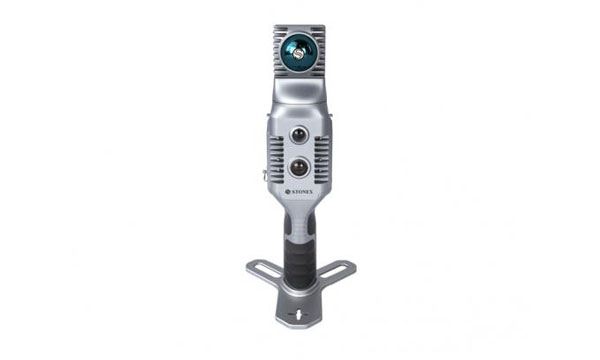
GNSS Receiver Featuring a multi-constellation antenna
The Stonex S900 GNSS receiver features a high-accuracy, multi-constellation antenna, a powerful UHF transmitter and the GSM 4G modem for a fully integrated communications choice, combined with a light and modern design. It tracks signals from GPS, GLONASS, BeiDou, Galileo and QZSS satellites. On the S900, two smart hot-swappable batteries can be inserted simultaneously, ensuring a maximum of 12 hours of operation. The power level can be checked and seen on the controller or directly on an LED bar on the battery.
The HydroBoat 1500 is a versatile unmanned surface vessel (USV) driven by four powerful thrusters and designed to carry out underwater topographic surveys of lakes, rivers, reservoirs and other bodies of water. With a payload capacity of 60 kg, it can be integrated with the SatLab HydroBeam M4 portable multibeam echosounder, as well as a variety of other payloads such as side scan sonars and ADCPs. The vessel is IP67-rated and includes a millimeter-wave radar and 360° omnidirectional camera for accurate obstacle detection and safe navigation. It is also equipped with a dual RF and 4G cellular communications system.
The Jupiter Laser RTK integrates GNSS, auto-IMU (inertial measurement unit), laser and dual-camera systems into a single unit. It incorporates a precise green laser that remains visible even in bright daylight. This feature allows for precise measurements of points in hard-to-reach, signal-blocked or potentially hazardous locations. It also features a night vision camera, allowing users to see feature points even in low-light conditions.
The RTK system’s laser range is up to 50 m, making it suitable for challenging surveying environments. It incorporates visual technology to offer surveyors an immersive experience during surveying and stakeout operations, improving working efficiency and productivity.
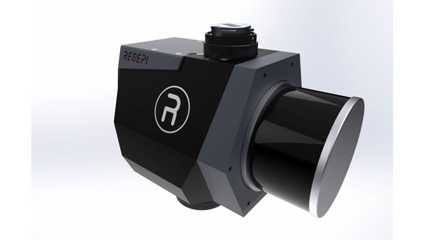
EchoONE combines Teledyne’s lidar and camera technology with Inertial Labs’ remote sensing payload instrument (RESEPI). EchoONE is designed for industries requiring precise aerial surveying and mapping solutions, such as land surveying, electric utility vegetation management, asset modeling, as well as transportation and infrastructure projects. Users can create detailed 3D models for infrastructure and asset management, offering valuable insights for maintenance and planning. EchoONE also generates fully undecimated georeferenced point clouds in real time, which allows for in-field verification. This capability is complemented by rapid post-processing through RESEPI’s “one-click” PC-Master Pro solution.
The i83 Pro is an inertial measurement unit (IMU) real-time kinematic (RTK) GNSS receiver. This receiver combines GNSS capabilities with extensive compatibility options to address the diverse needs of surveying, construction, and mapping professionals. It incorporates CHCNAV’s third-generation GNSS antenna and the latest iStar algorithm, designed to boost GNSS signal tracking efficiency by 30%, according to the company. With 336 channels supporting GPS, GLONASS, BeiDou, Galileo and QZSS constellations, it can achieve centimeter-level precision rapidly, even in challenging environments.
The i83 Pro supports various GNSS surveying modes, such as RTK Networks NTRIP and UHF base-rover configurations. It features an IP68-rated enclosure for dust and water protection, a compact and lightweight design for enhanced portability, a high-resolution color display for clear status information and a 20-hour battery life for continuous operation in rover mode.
LP360 Land is designed to process lidar, GNSS and SLAM data from handheld sensors, particularly the TrueView GO handheld scanner. It features a GIS interface that allows users to combine various geospatial datasets and offers SLAM point cloud processing capabilities. Additionally, LP360 Land includes advanced visualization tools that support multiple synchronized windows for 2D, 3D, profile and immersive views.
Its coordinate system management includes datum and projection transformations. The software also offers quality assurance and control (QA/QC) tools, along with data editing and cleaning functionalities. Users can perform manual and automatic registration of point clouds and utilize an image explorer for contextual analysis by linking point clouds to photos, which allows for the generation of accurate and colorized point clouds even in GPS-denied environments.
A roundup of recent products in the GNSS and inertial positioning industry from the March 2024 issue of GPS World magazine.
SURVEYING & MAPPING
GNSS Receiver Supports tilted measurement
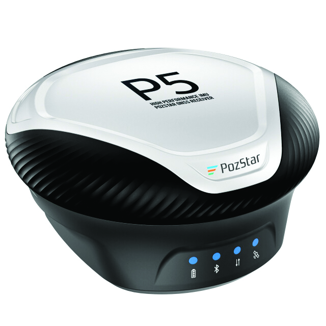
PozStar P5 is a high-precision GNSS receiver. It is powered by a 1,408-channel multi-band GNSS receiver designed to improve surveying in the field. It is equipped with Bluetooth, WiFi and UHF radio. The inertial measuring unit (IMU) supports tilted measurement, which allows users to obtain quick initialization and accurate measurements with an inclination of up to 60°.
The receiver comes with radio connector options used in a frequency range of 410 MHz to 470 MHz and a 5-pin serial port, which allows for external radio system connectivity and NMEA data output. It is also weatherproof, rated IP67.
PozStar P5 can collect control and surveying data for RTK equipment to perform surveying, map input and drawing operations. The receiver can be used with PozPad, an Android-based RTK field software.
PozStar, pozstar.com
Lidar System Designed for aerial surveying
The TrueView 540 lidar system integrates lidar technology with LP360 3D point cloud processing software to enhance survey-grade lidar applications.
The system is designed to provide enhanced data density, accuracy, and precision for aerial surveying. It combines lidar, an accurate positioning and orientation system and a full-frame industrial camera in a compact, lightweight package. It is suitable for a variety of UAVs, including the DJI Matrice 350.
The TrueView 540 features high-precision lidar technology comparable to high-end industry-standard payloads in terms of range, density and accuracy. It will be made available through GeoCue and its authorized distributors. GeoCue, geocue.com
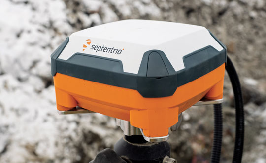
GNSS Solution Combined with Septentrio’s mosaic-X5 module
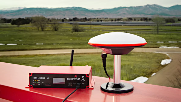
The SparkFun real-time kinematics (RTK) mosaic-X5 uses the multi-constellation, multi-frequency capabilities of the Septentrio mosaic-X5 module, which aims to improve accuracy and reliability in a variety of position applications.
The RTK mosaic-X5 is a 448-channel receiver that supports all four Global Navigation Satellite Systems (GNSS) — GPS, GLONASS, BeiDou and Galileo — and one of the two regional ones, NavIC. It can function as both an RTK base and rover, which allows users to achieve horizontal positioning accuracy down to 6 mm and updates at a rate of 100 Hz.
The device incorporates the Espressif ESP32-WROVER processor, which allows for high-speed processing and a variety of connectivity options. The ESP32 provides the device with USB-C, Ethernet-over-USB and an Ethernet to WiFi Bridge mode to ensure seamless integration into any project setup.
The device also has power flexibility, including USB-C, Power-over-Ethernet, and external DC sources, along with data logging in multiple formats such as RINEX and NMEA. Housed in a custom-designed aluminum case, the RTK mosaic-X5 features a comprehensive web server interface to simplify configuration and monitoring. SparkFun Electronics, sparkfun.com
Hybrid Mobile Mapping Solution Combines mobile scanning with a stationary mode
The X70GO SLAM laser scanner is designed for fast and efficient large-area surveys. It combines mobile scanning with a stationary mode to scan with high resolution to enhance overall surveying capabilities.
X70GO is a real-time 3D model reconstruction device that integrates an inertial navigation module, high-performance computer and storage system. It is equipped with a 360° rotating head, which, combined with the SLAM algorithm, can generate high-precision point cloud data. The built-in 512GB memory disk stores survey results and the dismountable handle has a 1.5-hour battery life.
A 12MP RGB camera offers texture information, while a visual camera aims to enhance the real-time preview with the GOapp. Mapping results can be generated immediately inside the scanner. Users can then color the points and improve their accuracy during post-processing with GOpost software.
The system comes with a hybrid scanning capability. The X-Whizz mode combines the advantages of SLAM mode with the resolution of a static scan, which eliminates the need for multiple scan stations. Users can move around the scene to collect the entire 3D point cloud without time-consuming cloud-to-cloud alignment.
The technology incorporated in the new scanner is designed to provide extended range, a higher number of points per second and advanced onboard processing algorithms. The SLAM laser scanner is well-suited for challenging environments and can be used in a variety of applications, including BIM, industrial sites, real estate, heritage preservation, tunnels and mining.
Users can add an RTK module to set a point cloud in a global coordinate system. This can support adding GNSS information to that from lidar and the inertial measurement unit (IMU) in the SLAM algorithm. In situations with limited GPS connectivity – such as indoors or in challenging environments – the system will rely on lidar and the IMU for positioning purposes. Stonex, stonex.it
Remote Sensing Payload Integrates with UAVs and other platforms
The RESEPI lidar Gen-II remote sensing payload instrument comes in three modes: aerial mode for comprehensive airborne data collection, mobile mode for dynamic vehicular data collection and a versatile handheld/backpack that aims to provide portability and ease of use for ground personnel.
The RESEPI lidar Gen-II has a 175% increase in computing power, designed to speed up processing and enhance efficiency during complex tasks. Its memory capacity has been increased by 700%, which allows for extensive data handling and improved system performance. The system’s 50% increase in storage capacity aims to facilitate longer durations of data collection without frequent offloads.
The Gen-II features seamless integration capabilities with UAVs and other platforms. The system’s sensor-agnostic design allows for external sensors to be easily integrated, including lidar and cameras. It also can compute point clouds, trajectories and solutions in real-time, which is critical in time-sensitive missions. The system can be used in a variety of applications including mapping, inspection, autonomous vehicles, navigation and robotics. Inertial Labs, inertiallabs.com
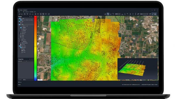
Mapping Software With upgraded cloud capabilities
The Correlator3D mapping software now has upgraded cloud capabilities. With its distributed processing capabilities, Correlator3D allows users to scale their processing to match individual operational needs.
With the upgrade, Correlator3D can process large mapping projects and deliver results from UAV, aircraft and satellite imagery. It features a software package – a patented, end-to-end photogrammetry solution — designed to generate high-quality geospatial data from a variety of sources, including satellite and aerial imagery and UAVs. The upgrade aims to improve the technology’s performance in diverse cloud scenarios.
Correlator3D is designed to provide aerial triangulation (AT) and generate dense digital surface models (DSM), precise digital terrain models (DTM), point clouds, orthomosaics, 3D models and vectorized 3D features. By using GPU technology and multi-core CPUs, Correlator3D offers enhanced processing speed to support the rapid production of large datasets. SimActive, simactive.com
MOBILE
Handheld GNSS Data Collector Ideal for construction surveying
TDC6 is a handheld GNSS data collector designed for high-performance construction surveying. The device allows contractors to work with more complex data sets more effectively in the field, connect to the office for on-the-spot approvals, and quickly communicate changes to field crews.
The small, rugged device offers integrated Wi-Fi and Bluetooth, built-in cameras and 5G compatibility in a lightweight, shock-, dust- and water-resistant package. The device integrates seamlessly with Trimble data collection applications, including Trimble TerraFlex GIS software and Trimble Access survey field software, as well as third-party apps such as Esri ArcGIS Field Maps. Trimble Geospatial, geospatial.trimble.com
Military-Grade Antennas Designed for mission-critical applications
This advanced military-grade antenna product line includes ruggedized GPS, manpack omni and vehicle omni antennas. The products are designed for mission-critical applications such as vehicle navigation, personnel communications, vehicle communications, electronic warfare, and jamming.
The antennas meet MIL-STD-810 to offer durability while adhering to strict quality standards. The antennas also are compliant with the Trade Agreements Act (TAA), which makes them suitable for government and defense applications.
Built to withstand tough conditions, these antennas feature heavy-duty construction and a rugged design for long-lasting performance in challenging environments. They are designed to perform in extreme weather conditions and on rough terrains.
Its robust construction and NATO/U.S. standard mounting options aim to simplify integration into various setups during critical operations. Fairview Microwave, fairviewmicrowave.com
Trimble SiteVision Software 5.0. (Image: Trimble)
Outdoor Augmented Reality System With 3D scanning capabilities
SiteVision Software 5.0 is a high-accuracy outdoor augmented reality system, now with a 3D scan tool. The new 3D scan tool allows users to use lidar sensors available on some Apple Pro devices. The Trimble DA2 GNSS receiver is designed to capture point clouds efficiently and accurately with a single handheld solution.
Users can visualize 3D scan data directly in the field with SiteVision’s augmented reality view. The software allows users to create as-builts of the job site on the go, measure and plan resource allocation, reduce scan times, supplement UAV data and more by combining scanning and precision in a mobile solution. The product aims to facilitate practical and accessible field-to-office workflows for surveyors, contractors and engineers.
Trimble Geospatial, geospatial.trimble.com
OEM
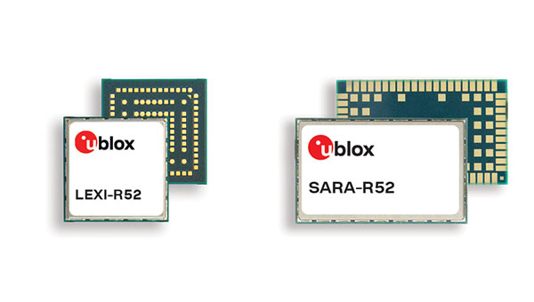
Two LTE Modules With integrated GNSS
The LTE-M cellular module series, the SARA-R52 and LEXI-R52, are designed to meet the needs of industrial applications requiring both positioning and wireless communication capabilities. Based on the u-blox UBX-R52 cellular chip, these modules are designed for a variety of internet of things (IoT) use cases, including both fixed and mobile applications.
The UBX-R52 chip is designed to simplify product design by reducing the need for additional components. It includes SpotNow, a positioning function developed by u-blox, which aims to provide location data with an accuracy of up to 10 m within a few seconds. This function is targeted at applications requiring occasional tracking, such as waste management, personal trackers and industrial machinery.
The chip’s uCPU feature allows the execution of custom software directly on the chip and eliminates the necessity for an external microcontroller unit (MCU). The smart connection manager (uSCM) is a feature designed to manage connectivity automatically, focusing on optimizing performance or minimizing power consumption under varying connection conditions.
The R52 series introduces the SARA-R520M10 combo module, which is equipped with an integrated u-blox M10 GNSS receiver. This module is designed to provide simultaneous GNSS and cellular connectivity, supporting applications that require continuous or periodic tracking with features such as low power consumption, improved time-to-first-fix (TTFF) and increased RF sensitivity.
Unlike many LTE-M modules that typically offer an RF output power of 20-21 dBm, the new R52 series modules offer a higher output power of 23 dBm to improve connectivity in difficult coverage areas. The LEXI-R52 offers the same functionalities as the SARA-R52 but comes in a smaller form factor, making it ideal for applications with space constraints, such as wearable technology.
These additions to u-blox’s LTE-M module portfolio are designed to address the integration of GNSS and wireless communication in industrial IoT applications, offering solutions for a range of use cases that require robust connectivity. u-blox,u-blox.com
UAV
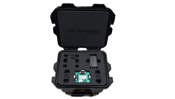
GNSS-Denied Navigation Kit For challenging environments
This GNSS-denied navigation kit is designed to offer navigation capabilities in challenging environments. It combines UAV Navigation’s attitude and heading reference system (AHRS), the POLAR-300, with its Visual Navigation System, the VNS01, to offer advanced dead reckoning navigation capabilities with minimal drift.
The technology has error rates as low as 0% to 1% over covered distances. This is made possible by the kit’s visual-based technology, which allows for precise attitude and position estimation to stabilize flights in challenging conditions. The kit is equipped with advanced algorithms that can detect and counter sophisticated spoofing and jamming techniques to offer reliable and secure navigation, even in the face of potential signal disruptions. The kit can be used in both civil and defense sectors.
UAV Navigation-Grupo Oesía, uavnavigation.com
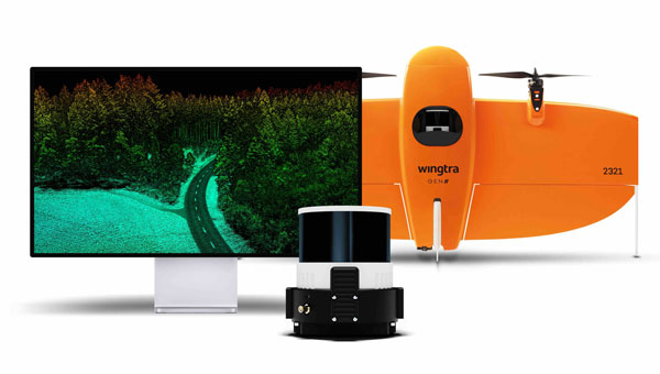
Lidar UAV Solution Offers immediate access to terrain information
The lidar UAV mapping solution combines the WingtraOne GEN II UAV with a newly developed lidar sensor. This integration aims to advance UAV lidar efficiency, increase accuracy and simplify integration.
The solution incorporates a Hesai scanner, Inertial Labs IMU and NovAtel GNSS receiver designed to optimize data acquisition and reduce the need for post-processing strip alignment. This advancement offers immediate access to precise terrain information following each flight and enhances the efficiency of mapping and photogrammetric analysis in various sectors.
One of the key features of the lidar system is its reduced field time, with no calibration needed and a one-minute initialization process. The Wingtra lidar application and the system’s automated features offer a streamlined data capture process, which makes it accessible even to those new to lidar technology.
The solution offers a vertical accuracy of 3 cm from a 60 m flight height, with leading point density in its class. The WingtraOne GEN II’s design and automated flight patterns offer consistent results across different pilots. Wingtra, wingtra.com
MACHINE CONTROL
GNSS Smart Antenna Designed for industrial environments
AntaRx-Si3 is a GNSS/INS smart antenna housed in an ultra-rugged enclosure, designed for straightforward installation on machinery such as agricultural robots. It combines Septentrio’s centimeter-level GNSS positioning with an inertial measurement unit (IMU) within the same enclosure as the GNSS antenna, which uses FUSE+ technology.
The AntaRx-Si3 is designed for challenging industrial environments where GNSS signals are at risk of obstruction, such as under heavy foliage. The antenna’s exterior is crafted from impact-resistant polycarbonate with an IP69K rating and can withstand significant shocks, vibrations, and harsh environmental conditions.
It uses Septentrio’s GNSS+ algorithms to offer advanced multipath mitigation to operate in environments where satellite signals could be reflected off surrounding machinery or structures, such as silos. The antenna delivers high update rates and low latency positioning, which are crucial for the control loops of autonomous movements or rotations. Septentrio, septentrio.com
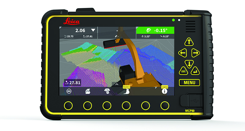
3D Machine Control Software Suitable for construction sites
The Leica MC1 software platform is designed to guide and automate machine control solutions.
Leica MC1 machine control software continues to evolve toward achieving a smart digital reality, with features such as Modify Models and surface logging. It compares the design model to the actual position of the machine’s cutting edge, such as the bucket or blade edge. The technology aims to assist operators in positioning machinery to achieve the planned design while allowing for a live digital representation of the progress. The software automatically controls the position of the machine’s cutting edge.
It is carried by the rugged hardware platform, the Leica MCP80 panel and MDS Series docking station, offering an interchangeable panel between machines on a job site. The MC1 platform is supported by the cloud-based Leica ConX productivity platform to offer more efficient management of heavy construction projects.
Leica Geosystems, part of Hexagon, leica-geosystems.com
AllTerra, a Trimble geospatial dealer, has joined the GeoCue distribution network. AllTerra will provide GeoCue’s full line of TrueView 3D imaging sensors, a UAV, lidar and photogrammetry solution. The technology enables fast, automated generation of true 3D colorized point clouds, oblique imagery and orthophotos from a single UAV flight.
AllTerra is also authorized to sell LP360 lidar and photogrammetry 3D point cloud software. LP360, an advanced desktop lidar software package, simplifies extracting information and generating deliverables in a GIS environment.
The company offers Trimble and Spectra Precision solutions in surveying, MGIS, marine, forensics, mobile mapping and infrastructure. Alltera also offers mobile/airborne lidar and photogrammetry solutions from GeoCue and Microdrones.
A roundup of recent products in the GNSS and inertial positioning industry from the March 2023 issue of GPS World magazine.
UAV
Image: InfiniDome
Anti-Jamming Device Provides protection from three directions of attack
The GPSdome 2 is tailored to defend small- to medium-sized tactical UAVs as well as manned and unmanned ground vehicles. With a small form factor (500 g, 87 mm x 91 mm x 61.55 mm) and minimal power consumption, GPSdome 2 is suitable for loitering munitions as well as UAVs. Fully retrofit and completely standalone, the system is compatible with almost any off-the-shelf GNSS receiver as well as standard active GNSS antennas, meaning that it can be integrated into existing GPS systems or into new product lines, manned or unmanned. With sophisticated algorithms and a proprietary RFIC, GPSdome 2 analyzes RF interference in the environment and combines multiple antenna patterns to create and dynamically steer three nulls in the direction of any hostile signal. GPSdome 2 provides simultaneous dual-frequency protection (GPS L1 + L2 or GPS L1 + GLONASS G1), creating up to three nulls, protecting from three jamming directions within each band in real time, making it suitable for PNT applications. The GPSdome 2 is a dual-use, non-ITAR device and comes with optional mil-spec compliance. InfiniDome, infinidome.com
Image: uAvionix
Command and Control Designed for easy integration
The SkyLine C2 management platform and muLTElink airborne radio systems (ARS) are designed to integrate, which enables a self-healing command-and-control network capable of both path and link diversity. This eliminates lost-link possibilities over broad terrain and altitude ranges. MuLTElink ARS consists of two models — muLTElink915 and muLTElink5060, the core of the uAvionix C2 system. The muLTElink915 model combines globally licensed aviation LTE, enhanced with frequency hopping 902 MHz – 928 MHz industrial, scientific and medical frequencies capability. The muLTElink5060 model combines global LTE with aviation-protected 5,030 MHz – 5,091 MHz C-band. Each muLTElink model allows up to one external CNPC radio to be optionally connected to allow simultaneous use of all three frequency ranges, higher power C-band operation or future radio integrations. uAvionix, uAvionix.com
Image: Atmos
VTOL UAV With Sony a7R mark III and IV camera
Atmos has integrated the Sony a7R mark III and IV cameras into its vertical take-off and landing (VTOL) fixed-wing UAV, the Marlyn Cobalt. This will increase coverage and accuracy achieved in a single flight for surveyors. Both cameras have an ISO of 32,000, which is expandable to 102,400, and camera sensors with high megapixel count — 42,4 MP for the a7R III and 61 MP for the a7R IV. When combined with Zeiss’ 35 mm and 21 mm lenses, it enables UAV surveyors to achieve ground sample distance levels below one 1 cm. The integration of the two cameras enables Marlyn Cobalt users to map an area of 210 ha with centimeter-level accuracy in a single flight. Atmos, atmosuav.com
Trueview 720. (Image: GeoCue)
TrueView 535. (Image: GeoCue)
Accuracy Star. (Image: GeoCue)
UAV and Lidar Systems Suitable for geospatial professionals
TrueView 535 consists of updated lidar sensors, adding a third return, increasing mapping abilities below canopy. An additional third nadir camera offers another point of view and improves photogrammetry quality. It also includes a longer, usable lidar range to increase flexibility. TrueView 720 is a fourth-generation Riegl VUX-120 with three laser beam orientations. It provides high-point density corridor mapping. Using the Riegl VUX-120 with three laser beam orientations (nadir, +10 degrees forward and –10 degrees backward) and three oblique/nadir cameras enables data collection from more surfaces in one flight path. One application of TrueView 720 is scanning power lines. Users can capture the poles vertically, front and back. The extreme range of this system means it can be integrated with UAVs, airplanes or helicopters. In addition to the two sensor payloads, GeoCue has launched its LP360 software add-on for processing and visualization — the 3D Accuracy and the Accuracy Star hardware.
GeoCue, geocue.com
OEM
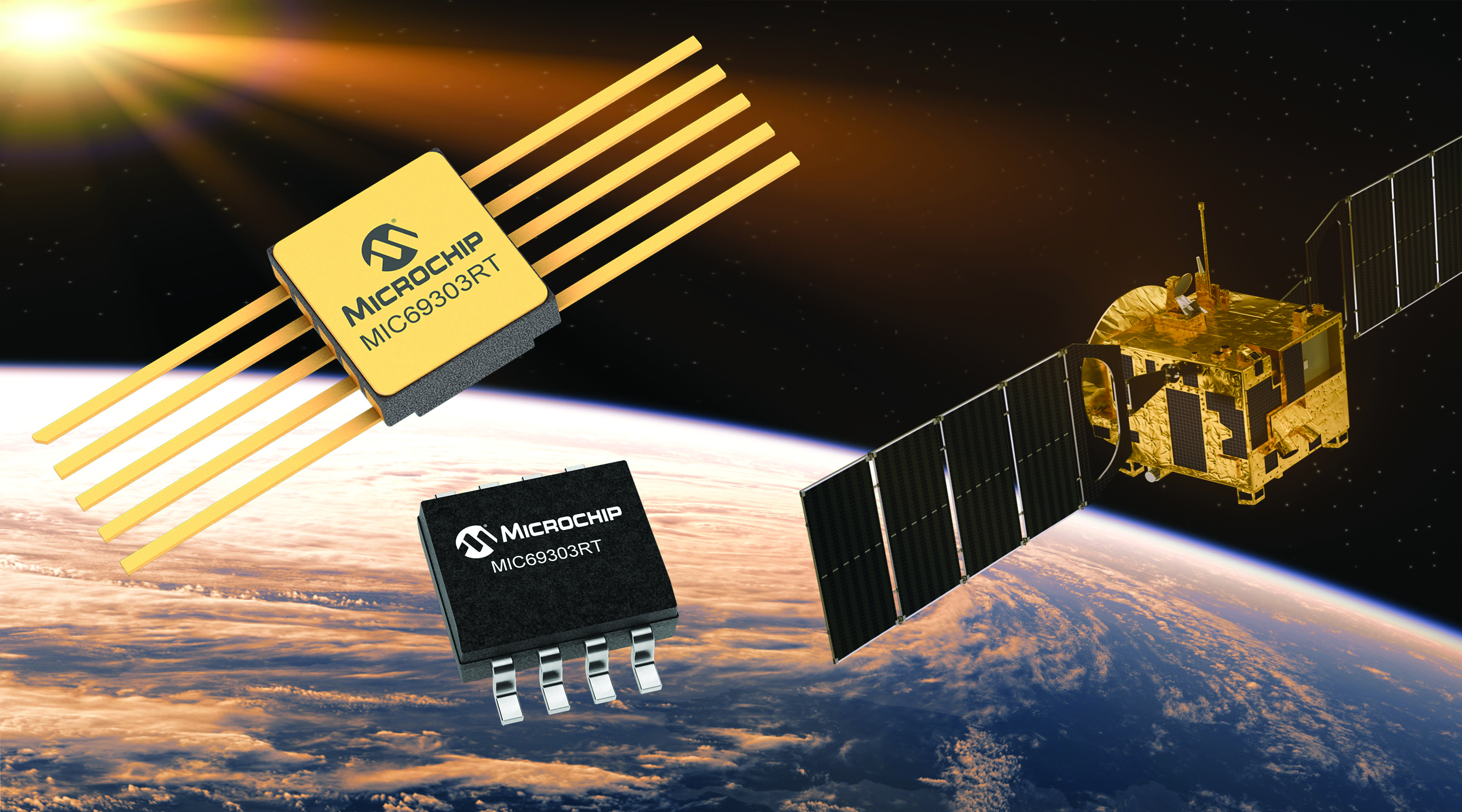
Image: Microchip
Voltage Regulator Device for LEO space application
The MIC69303RT is a radiation-tolerant power management device for space application developers. It is a high-current, low-voltage device targeting low-Earth orbit space applications. The MIC69303RT operates from a single low-voltage supply of 1.65 v to 5.5 v and can supply output voltages as low as 0.5 v at high currents. It offers high-precision and low dropout voltages of 500 mv under extreme conditions. The MIC69303RT is a companion power source solution for microcontrollers, such as the SAM71Q21RT and PolarFire field-programmable gate arrays. MIC69303RT is designed for harsh aerospace applications and remains operational in temperature ranges from -55 C to +125 C. Microchip Technology, microchip.com
Image: Spirent Communications
LEO Satellite Device Designed for GNSS/PNT lab testing
SimORBIT is a low-Earth-orbit (LEO) satellite solution software designed to aid developers in determining LEO orbits more accurately for GNSS/PNT lab testing. The software replicates LEO orbits so that simulations can provide the realistic environment of a LEO satellite, including gravitational and atmospheric impacts the satellite could encounter in space. Developers can create non-ICD signals via I/Q injection, or by the “Flex” feature, generating space-centered PNT signals to be developed in the lab as realistically as possible. Spirent Communications developed SimORBIT in partnership with SpacePNT. Spirent Communications, spirent.com
Image: Sony
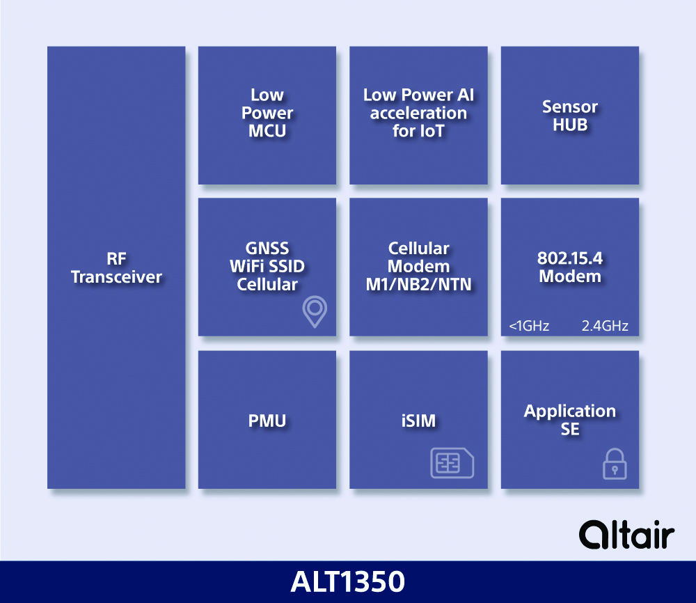
5G Chipset Includes GNSS
The ALT1350 implements GNSS, cellular and Wi-Fi-based location in a single chipset. The cellular LTE-M/NB-IoT chipset is designed to enable additional low-power, wide-area (LPWA) communication protocols; intermittent LTE and GNSS (GPS/GLONASS) navigation for low-cost applications; and concurrent LTE and L1/L5 GNSS for tracking applications. The ALT1350 incorporates a sensor hub to collect data from the sensors while maintaining ultra-low power consumption. It also provides cellular and Wi-Fi-based positioning and is tightly integrated to provide power-optimized concurrent LTE and GNSS to accommodate various tracking applications, which can be demanding with a single chip. The chip is designed to enable deployments for the internet of things (IoT), including location technologies. Sony, altair.sony-semicon.com
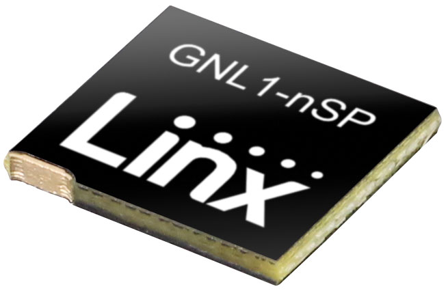
The ANT-GNL1-nSP is a surface-mount embedded GNSS antenna supporting GPS, Galileo, GLONASS, BeiDou and QZSS in the L1/E1/B1 bands. The ANT-GNL1-nSP antenna exhibits high performance in a compact size (10 mm x 8 mm x 1 mm) and features linear polarization and an omnidirectional radiation pattern. The antenna is available in tape and reel packaging and is designed for reflow-solder mounting directly to a printed circuit board for high-volume applications. Linx Technologies, linxtechnologies.com
Image: OriginGPS
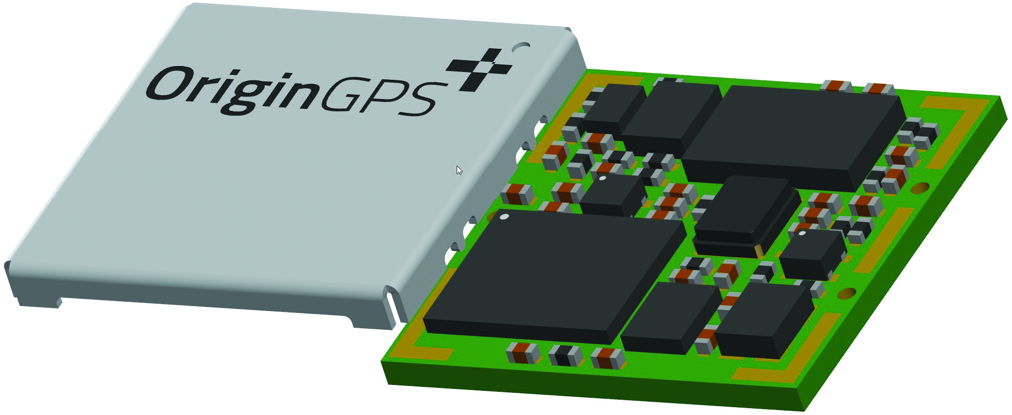
GNSS Module Based on a MediaTek chipset
The ORG4600-MK01 dual-frequency module provides higher precision than the company’s previous modules. It has sub-1 m precision at a cost lower than that of the company’s first L1+L5 module, the ORG4600-B01, which is based on Broadcom’s chipset. The 10 mm x 10 mm ORG4600-MK01 was designed for applications deployed in challenging environmental conditions. The solution also includes RTCM, a logger and accurate orbit prediction. OriginGPS, origingps.com
MAPPING
Image: Mapbox
Navigation Software Includes enhancements to existing software and more
Navigation software development kit version 2.9 provides pre-built applications compatible with Android and IOS. SDK v2.9 provides the primary navigation components across a workflow using lines of code instead of starting from square one. The drop-in user interface is customizable to reflect a developer’s brand, obviating the need to manually develop a full end-to-end application. Navigation SDK Copilot — a backend analytics tool for CX on navigation applications — collects trace files of navigation sessions and search analytics data from users. Developers can use this data to gather feedback and collective user data to create touch points with users and improve application experience based on their data-drawn conclusions. Matrix API has been updated to support scheduled departure times and provide optimal driving routes, creating a more accurate estimated time of arrival. Mapbox, mapbox.com
Image: Hexagon
Defense Platform For developing Android applications
LuciadCPillar is designed for the development of mobile applications for dismounted soldiers in the field. Developers can build applications with 2D and 3D views. It features military symbology and supports many geospatial data types including vector data, raster data, elevation data, point clouds and 3D meshes. It has the same capabilities found in desktops, in-vehicle and browser applications built with LuciadLightspeed, LuciadCPillar and LuciadRIA. The platform offers capabilities to match high-resolution screens, graphic processing units and multi-core processors including the ability to display 3D data in mobile applications. LuciadCPillar supports ARM processors and an application programming interface, which aligns with the Android developer experience. Impact, a French system integrator, partnered with Hexagon to test LuciadCPillar and will integrate it into its Delta Suite product, which is used by the French Special Operations Command. LuciadCPillar is part of Luciad 2022.1, which is available now globally. Hexagon, hexagon.com
Image: Golden Software
Surface Mapping Designed for 3D surface mapping
The Surfer package is designed for 3D surface mapping and provides robust subsurface visualization and modeling functionality by incorporating many true 3D gridding and visualization tools. With the enhanced functionality, users can now model an additional variable, a C variable, such as a contaminant or chemical concentration, along with the traditional X, Y, Z values. Surfer also includes the ability to create a 2D map of a slice-through 3D grid, which users can move up and down through the grid, illustrating how the C value changes with depth. Part of Surfer’s enhancements is isosurface creation, enabling visualization of the 3D grid in the 3D view as an isosurface, providing another way to see how C data varies with depth or elevation. The new 3D-rendered volume functionality also allows users to visualize the 3D grid in the 3D view as a solid body by assigning colors to different C values, highlighting variations in the data. Golden Software, goldensoftware.com
GeoCue has released the TrueView 535 imaging system for UAVs, and the TrueView 720, its fourth-generation Riegl integration. It also launched its LP360 software add-on called 3D Accuracy and the Accuracy Star hardware.
TrueView 535 is built on TrueView 515’s technology and consists of updated lidar sensors, adding a third return, increasing mapping abilities below canopy. An additional third nadir camera offers another point-of-view and improves photogrammetry quality. It also includes a longer, usable lidar range to increase flexibility.
TrueView 535. (Image: GeoCue)
TrueView 720 is a fourth-generation Riegl VUX-120 with three laser beam orientations. It provides high point-density corridor mapping. Using the Riegl VUX-120 with three laser beam orientations (nadir, +10-degrees forward and –10-degrees backward) and three oblique/nadir cameras enables data collection from more surfaces in one flight path.
Trueview 720. (Image: GeoCue)
One application of TrueView 720 is scanning power lines. Users can capture the poles vertically, front and back. The extreme range of this system means it can be integrated with UAVs, airplanes or helicopters.
In addition to the two sensor payloads, GeoCue has launched its LP360 software add-on for processing and visualization — the 3D Accuracy and the Accuracy Star hardware.
Accuracy Star. (Image: GeoCue)
“When used together, Accuracy Star and the 3D Accuracy add-on provide automated horizontal and vertical checks,” said Darrick Wagg, vice president of customer success for GeoCue. “You can automatically find a 3D target on a drone dataset. The software will calculate the correction for any 3D target and provide a seamless workflow to apply the correction on the point cloud.”
These products are suitable for geospatial professionals.
GeoCue, a U.S. LiDAR data technology company, has announced its latest True View 3D Imaging Systems (3DIS) product, the True View 645/650. Combined with GeoCue’s integrated data processing software suite, True View EVO, all GeoCue 3DIS products include the full post-processing software workflow, including direct integration with Applanix POSPac.
The survey-grade True View EVO supports the direct creation of many standard project deliverables including ground classified point clouds, surface models, contours, Digital Elevation Models (DEMs), volumetric analysis, wire extraction and similar products without the need for additional third-party software.
According to GeoCue CEO Frank Darmayan, the newest True View 645/650 includes a Riegl mini VUX3-UAV laser scanner and dual mapping cameras. This system delivers colorized LIDAR deliverables with accuracy better than 3cm RMSE for the True View 645, and better than 2cm for the True View 650.
The mini VUX-3UAV, a 360° rotating mirror scanner, increases the scanner frequency to 300 kHz and offers a unique mode where the 200,000 pulse per second scan rate is focused in a 120° cross-track field of view, providing significantly increased point densities in aerial mapping applications.
A roundup of recent products in the GNSS and inertial positioning industry from the June 2021 issue of GPS World magazine.
OEM
Grandmaster Clock
Multi-constellation receiver
Photo: Microchip
The upgraded TimeProvider 4100 2.2 is now more redundant and resilient. It provides secure, precise timing and synchronization for critical infrastructure such as 5G wireless networks, smart grids, data centers, cable and transportation services. The 4100 2.2 introduces a software-redundancy architecture for flexible deployment, and supports a new GNSS multi-band, multi-constellation receiver to protect against time delay from space weather, solar events and other disruptions. The 4100 2.2 offers options for software and hardware support.
The NETZ 5-in-1 multiple-input and multiple-output (MIMO) solution combines two LTE antennas and two Wi-Fi antennas with a GNSS antenna for high data throughput and streaming, video, industrial and internet of things (IoT) applications. It offers a low-profile design with integrated SubMiniature version A (SMA) connectors and is designed with rugged PC+ABS plastic black housing for demanding environmental challenges.
The GW16143 is a high-precision GNSS/GPS Mini-PCLe adapter card that provides precise positioning to applications using Gateworks single-board computers. Based on the U-blox ZED-F9P, the GW16143’s multi-band real-time kinematic (RTK) technology enhances convergence times and performance. The module receives GPS, GLONASS, Galileo and BeiDou; supports L1 and L2/L5 bands; and provides GNSS positioning accuracy
of <2 cm.
Tactical grade for higher order integrated applications
The IMU-NAV-100. (Photo: Inertial Labs)
The IMU-NAV-100 is a fully integrated inertial solution that measures linear accelerations, angular rates, and pitch and roll with high accuracy utilizing three-axis high-grade micro-electro-mechanical systems (MEMS) accelerometers and three-axis tactical-grade MEMS gyroscopes. It features continuous built-in test, configurable communications protocols, electromagnetic interference protection, and flexible input power requirements that allow it to be easily integrated in a variety of higher order systems. The IMU-NAV-100-S offers high performance stabilization for line-of-sight systems, motion-control sensors, and platform orientation and stabilization systems. The IMU-NAV-100-A is for GPS-aided INS, AHRS and motion reference units.
The SimpleRTK2B single-board computer is built around up to three u-blox ZED-F9P high-precision GNSS receivers to simplify development of centimeter-level positioning solutions supporting real-time kinematics (RTK). It was developed to make RTK technology as close to plug-and-play as possible, and make the technology accessible to broader audiences. In addition to working as a stand-alone solution, customers can program their own applications with the company’s microPython API. The SimpleRTK2B-SBC delivers mechanical integration with centimeter position on three axes (heading, pitch, roll), outputting on NMEA, RTCM, RS232 and CANBus interfaces via Ethernet, Bluetooth, Wi-Fi and 2G/3G/4G communication.
PointMan software is now integrated into the Vivax Metrotech vLoc3 with a GNSS real-time kinematic (RTK) receiver to create a utility-locate device. Using the RTK-Pro internal cellular module with 4G LTE capabilities, the operator can connect to the NTRIP RTK caster that provides RTCM 3 corrections. With the integration of PointMan with the vLoc3 RTK-Pro, critical buried infrastructure can be captured, recorded and displayed at survey-grade without additional external equipment or post-processing. The integration provides centimeter accuracy of the precise location of buried utilities in real time. Data collected includes the type of utility, the depth of cover and the utility’s precise location.
ProStar Holdings, prostarcorp.com
GIS platform
Geospatial and location intelligence for smart cities
Screenshot: Hexagon Geospatial
M.App Enterprise 2021 is a significant update to the platform for creating geospatial and location intelligence applications. The latest release features new browser-based 3D capabilities and enhanced visual effects, plus the ability to create and configure custom applications more easily. It allows users to access LuciadRIA’s 3D features with support for panoramic imagery, shading, ambient occlusion and other visualization effects to build browser-based solutions. It also features a new browser app configurator that makes it easier to create spatio-temporal dashboards, or Smart M.Apps. Feature Analyzer now allows users to add and manage multiple datasets on the fly and set up workflows.
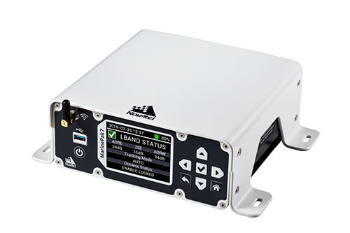
Measures positioning, heading, attitude, velocity and heave
Photo: Hexagon | NovAtel
The MarinePak7 marine-certified GNSS receiver is designed for nearshore applications. The multi-constellation, multi-frequency receiver was engineered to receive the Oceanix Correction Service from NovAtel, providing horizontal accuracy up to 3 cm (95%) in a marine environment. With SPAN GNSS+INS technology capabilities, the MarinePak7 couples GNSS and inertial measurement units (IMUs) for 3D positioning.
The ANNA-F9 high-precision GNSS Mini-PCIe card can achieve centimeter-level accuracy. It integrates the U-blox ZED-F9 receiver platform, providing multi-band GNSS (GPS, GLONASS, BeiDou, Galileo, QZSS and SBAS) and RTK positioning, and can be integrated with embedded systems. It provides high-accuracy positioning for applications including lane-level navigation and railway transportation. The ANNA-F9 series supports RTCM formatted corrections and centimeter-level positioning from local base stations or virtual reference stations in a network RTK setup.
Marine vessels often host both Iridium (1616–1626.5 MHz) and Inmarsat (uplink: 1626.5–1660.5 MHz) satellite communication antennas that transmit and receive signals. The VSP6037L-MAR and VSP6337L-MAR VeroStar marine antennas strongly attenuate interference from both signal sources, providing 75 dB to 85 dB of attenuation over Iridium and 85 dB to 95 dB over Inmarsat uplink, enabling clean GNSS signal reception and precise positioning. The VSP6037L-MAR supports the full GNSS spectrum; the VSP6337L-MAR supports GPS/QZSS-L1/L2/L5, GLONASS-G1/G2/G3, Galileo-E1/E5a/E5b, BeiDou-B1/B2/B2a, and NavIC-L5 signals. Both antennas support L-band correction signals. Every VeroStar antenna features a robust pre-filter and a high-IP3 LNA architecture, minimizing desensing from high-level out-of-band signals, including 700 MHz LTE, while still providing a noise figure of 1.8 dB. They meet IEC 60945 and IEC 61108 marine certifications for challenging marine environments.
The managed internet of things (IoT) Acculink Cargo can track the location and condition of high-value and sensitive assets, providing real-time visibility, product-level tracking and exception-based monitoring as goods move through their supply chains. Tracking can be used to avoid delays, minimize dwell time, prevent theft and remediate environmental conditions that can cause asset damage.
The GNS1559MPF or Mini GNSS is a rugged, high-performance and cost-effective solution for most GNSS or asset-tracking applications. The small form factor makes it easy to install on or in vehicles or buildings. It is IP67 rated to withstand impact as well as water and dust intrusion in demanding environments and operating conditions. The antenna can be configured with different cable types in varying lengths and with various connector types. Uses include public safety, in-building, fleet management, asset tracking, vehicle and personnel tracking.
The Zala 421-16E5G long-flight UAS is a domestic unmanned aerial system with a hybrid power plant. The non-aerodrome-based system is capable of providing aerial monitoring covering distances of more than 150 kilometers and staying in the air for more than 12 hours. Its power plant charges a buffer battery for an hour, allowing the UAV to fly long distances. It is equipped with two thermal imagers and a 60x video camera. Alternatively, it can carry a payload of up to 10 kg.
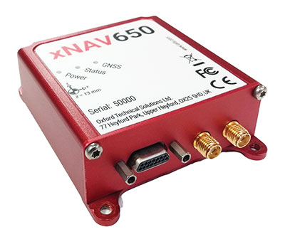
The xNAV650 inertial navigation system (INS) provides surveyors with absolute position, timing and inertial measurements (heading and pitch/roll) that they can integrate into their projects. When combined with data from other devices (such as lidar sensors and cameras), the INS measurements can greatly enhance the surveying process. The xNAV650 has the latest micro-electro-mechanical (MEMS) inertial measurement unit (IMU) technology and survey-grade GNSS receivers. At 77 x 63 x 24 mm and 130 grams, it is suitable for a wide range of UAV data-collection applications: surveys of bridges, buildings, forests and rail; coastal monitoring; map creation; and pipeline exploration. Data collected can be fused with data from almost any lidar sensor. OxTS NAVsuite software is included with all OxTS INS. Other optional software is available, including precision time protocol and GX/IX tight-coupling technology.
The AlphaAir 450 (AA450) lidar system is a lightweight, compact all-in-one sensor. Featuring an inertial measurement unit (IMU), GNSS receiver and 3D scanner and camera, the AlphaAir 450 is suitable for power-line inspections, topographic mapping, emergency response, agricultural work and forestry surveys. The unit can be rapidly deployed in the field to collect geospatial data. It achieves absolute accuracy of 5 cm (vertical) and 10 cm (horizontal) for small survey areas. Adjustment algorithms applied in CHCNAV CoPre software further improve precision and accuracy. The AA450 weighs 1 kilogram for easy mounting on a UAV. It is IP64 rated against dust and water spray and operates at –20° C to +50° C.
The True View 635/640 3DIS is GeoCue’s second-generation lidar/camera-fusion platform designed to generate high-accuracy 3D colorized lidar point clouds using the Riegl miniVUX-3UAV. All 3DIS platforms include GeoCue’s data-processing software suite True View EVO, which integrates with the Applanix POSPac. With its 120° fused field of view, the True View 635/640 provides 3D mapping with excellent vegetation penetration and wire detection in a payload package of 3.2–3.6 kg. True View EVO supports the direct creation of ground classified point clouds, surface models, contours, digital elevation models, volumetric analysis, wire extraction and similar products, without the need for additional third-party software.
GeoCue Group has released the True View 615 and True View 620 UAS lidar 3D imaging systems. The True View systems are compact, survey-grade 3D imaging sensors designed for small unmanned aerial systems.
True View 615 and 620 are equipped with Riegl’s miniVUX-2UAV laser scanner integrated with dual photogrammetric cameras. Position and orientation is provided by an Applanix APX-15 (True View 615) or extreme accuracy APX-20 (True View 620).
All True View 3D imaging systems are bundled with Applanix POSPac, True View EVO post-processing software and True View Reckon data management solution.
The Riegl laser scanner and dual photogrammetric cameras have been carefully configured to provide a fused lidar/imagery field of view of up to 120°. The system includes full post-processing software that generates a stunning ray-traced 3D colorized point cloud and geocoded images.
An upgrade path will be available to promote a True View 615 to a True View 620 by adding the Applanix APX-20 external inertial measurement unit.
The True View product line gives mappers and surveyors the ability to deliver high-quality analytic data with exact accuracies. These deliverables are generated using workflows and tools within GeoCue’s post-processing software, True View EVO. Examples of derived products include bare Earth models, profiles, cross sections, topographic contours, volumetric analysis and more.
“Our Quanergy-based True View 410 has rapidly become the standard for general purpose drone 3D Imaging, where moderate vegetation penetration and accuracies of 5 cm RMSE are adequate,” said GeoCue’s President, Lewis Graham. “The True View 615/620 provides a solution for situations where deeper vegetation penetration, wire extraction and extreme accuracy are required. These are great new additions to the True View product line.”
The True View 615/620 will be available for shipment late June.
The National Trust for Scotland commissioned Glasgow-based GeoGeo to carry out a drone survey of the inner Hebridean islands of Canna and Sanday in November 2018. Using an ultra-high-definition camera, the GeoGeo team not only pinned down the exact locations of archaeological features, but also revealed new archaeological sites.
Over five days,the drone navigated 400 kilometers to capture 4,000 images at a 3-centimeter resolution. After processing, the images created a minutely detailed 3D map capable of being used in a 3D printer to create scale models of the islands. With more than 420 million data points, it is currently the world’s largest complete island dataset captured by drone, claims GeoGeo founder Paul Georgie.
Screenshot: GeoCue
“We were blown away by the results and the possibilities of this technology,” said Derek Alexander, head of Archaeology at the Trust. “We’ve previously recorded archaeology on Canna and Sanday which proves that there were inhabitants as far back as the Neolithic, but this survey gives us information and detail we just haven’t had until now. We’ve been able to obtain exact plots of known sites, but also recorded the extensive traces of cultivation, such as rig and furrow field systems that range in age from the Bronze Age onwards.”
Screenshot: GeoCue
The cameras and software also will be able to help with seabird counts and habitat and coastal erosion monitoring, which are currently expensive and labor intensive, Alexander said. The trust will use the maps to update archaeological records and prepare for future groundwork and excavations.
DJI Phantom 4 Pro with Loki PPK system. (Photo: GeoCue)
GeoCue Group (via its wholly owned AirGon subsidiary) has completed the integration of the DJI Phantom 4 Pro RTK (P4R) into its AirGon Sensor Processing Suite (ASPSuite).
ASPSuite is a post-processing solution for GeoCue’s Loki direct geopositioning system for DJI and other manufacturer’s drones.
ASPSuite enables integration of the P4R with third-party L1/L2 GNSS base stations such as systems from Septentrio, Leica, Trimble, Topcon, CHC and others in a high accuracy post-process kinematic (PPK) workflow.
In addition to PPK processing, ASPSuite includes support for options often required in engineering-grade surveys such as:
vertical transforms (such as ellipsoid to country-specific geoids)
creation of and transformation between collection datums and local coordinate systems (site calibration)
application of antenna static and dynamic lever arm corrections
full support for Loki direct geopositioning systems.
The DJI D-RTK-2 base station (optionally available) for the P4R can only be used in RTK mode, and then only if it is being sited on a known location. The D-RTK-2 does not currently allow access to an observation file, preventing it from being stationed using an online positioning service such as OPUS, AUSPOS, Canadian Geodetic Survey services and so forth. An additional consideration in the integration into ASPSuite is that professional surveyors already have the survey kit that they need incorporated into this workflow.
GeoCue is offering camera calibration services for the P4R for customers who wish to do minimal or control-free high-accuracy mapping projects (the DJI “calibration” is an image de-warping algorithm, not a proper photogrammetric calibration). A test of a GeoCue-calibrated P4R using an OPUS-positioned base station and ASPSuite achieved about 4-cm horizontal and 5-cm vertical network accuracy (RMSE) with no ground control points.
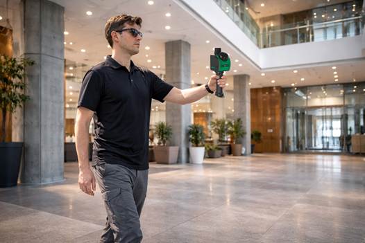


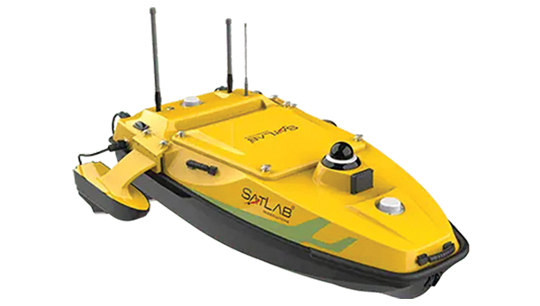
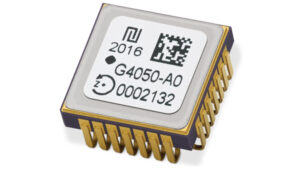 High-Dynamics MEMS Gyro
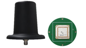 Anti-Jamming
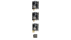 Triple-Band RTK Receivers
 OEM GNSS Antenna
 OEMs
OEMs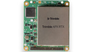 Direct Georeferencing Solution
 Fixed-Wing UAV
 GNSS Receiver
 USV
USV Laser RTK
 UAV Lidar Scanner
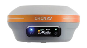 Receiver
 Software Solution