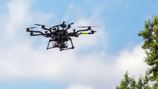
NASA researchers at Langley Research Center in Hampton, Virginia, have successfully flown multiple UAVs beyond visual line of sight (BVLOS) with no visual observer. The UAVs dodged one another and successfully maneuvered around obstacles before safely landing, the agency said. NASA conducted the tests to help researchers someday create autonomous, self-piloted helicopters that could carry passengers and cargo through busy aerospace.
Researchers used multiple Alta 8 UAVs loaded with software designed to enable autonomous flights. Although monitors observed the flights from a remote-control room at Langley, the UAVs successfully operated BVLOS.
NASA is also testing elements of autonomy using helicopters. They are designed to contribute towards the development of autonomous helicopters that can take off and land from “vertiports,” and transport passengers and cargo over both short and long distances.
The experiments are part of the agency’s Advanced Air Mobility Mission (AAM), which is designed to enable safe autonomous flight and integrate newly developed vehicles into the national airspace. The mission will “set the stage for a flourishing industry” of electric air taxis and UAVs by 2030, NASA says on its AAM website.
NASA will transfer the technology created during this project to the public to ensure industry manufacturers can access the software while designing their vehicles.
IBM, a global technology provider, has released its latest geospatial artificial intelligence (AI) initiative to address climate change. These efforts involve collaborations across various regions and uses advanced AI models designed for geospatial applications.
Central to these initiatives is IBM’s geospatial foundation model, developed jointly with NASA. These models aim to generate environmental insights and solutions related to climate change. Unlike traditional AI models, these use a vast amount of climate-relevant data to accelerate the analysis of various environmental aspects that are affected by climate change.
“AI foundation models utilizing geospatial data can be a game-changer, allowing us to better understand and address climate-related events with unprecedented speed and efficiency,” said Alessandro Curioni, IBM fellow and vice president of Accelerated Discovery.
Analyzing urban heat islands in UAE
IBM and the Mohamed Bin Zayed University of Artificial Intelligence (MBZUAI) have partnered to map urban heat islands in Abu Dhabi using a fine-tuned version of IBM’s geospatial foundation model. The goal of the project is to understand the impact of local landscapes on temperature anomalies, the company said. The initial results show a decrease in heat island effects, which can provide valuable insights for future urban design strategies.
Reforestation and water sustainability in Kenya
In partnership with Kenya’s Special Envoy for Climate Change, Ali Mohamed, IBM is supporting the National Tree Growing and Restoration Campaign. The initiative aims to plant 15 billion trees by 2032, particularly in critical water tower areas affected by deforestation. IBM’s geospatial model powers a digital platform to track tree planting activities, aiding local efforts in restoring forests and measuring carbon sequestration impact.
Elevating climate resiliency in the UK
In collaboration with the Science and Technology Facilities Council (STFC) and Royal HaskoningDHV, IBM is developing AI-driven tools for climate risk assessment in the UK. These tools will focus on assessing weather impacts on aviation operations, the company said. Additionally, the TreesAI research project aims to map areas suitable for tree planting to mitigate surface water flooding and offer urban developers a digital planning platform.
IBM extends collaboration with NASA for weather forecasting
IBM and NASA have partnered to develop an AI foundation model dedicated to weather and climate applications. The collaboration aims to enhance the accuracy and speed of weather forecasting, predict wildfire conditions and understand meteorological phenomena. IBM researchers will work closely with NASA to train and validate this model, IBM said.
It is no secret that the world has been burning for months. Devastating wildfires have encompassed Greece, Canada, the United States, and other parts of the world. These wildfires have incinerated entire communities, taken lives, and has had disastrous environmental effects. This wildfire outbreak can be attributed to several factors, but mainly the global climate crisis.
Why are these wildfires a monumental problem?
Widespread wildfires displace of thousands of people from their homes, raze entire communities and cities, wipe out farmland and other essential resources, create horrific air pollution — that causes inflammation of lung tissue and increases vulnerability to infections — and many other devastating effects.
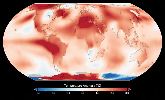
Image: NASA
As reported by NASA, July has been the hottest month on record since the 1880’s. This has caused extreme dry conditions that are ideal for wildfire outbreaks, among other natural disasters.
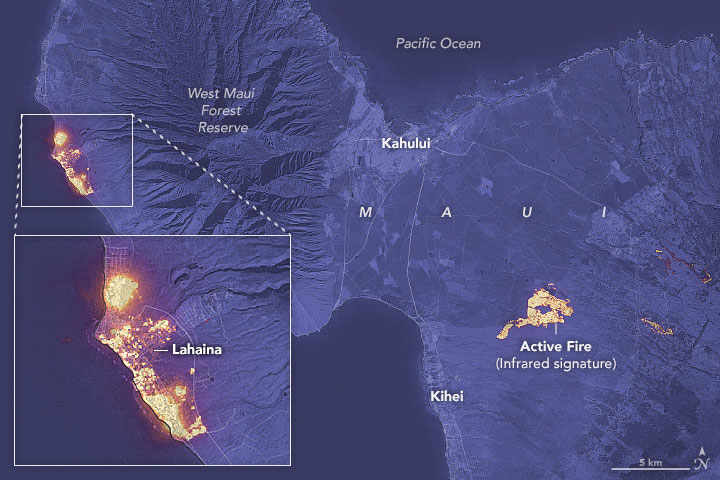
Image: NASA
Flames engulfed parts of Hawaii the morning of Wednesday, August 9, which destroyed a centuries-old town and killing at least 106 people as of August 16. The wildfires took natives and tourists on the island by surprise. Residents and tourists were forced to evacuate the area – including some who reportedly jumped into the ocean to escape the flames. The National Weather Service stated the combination of high winds and low humidity is what caused the dangerous fire conditions across the island. The devastating fire left behind burned-out cars on once busy streets and smoking piles of debris where historic buildings once stood.
Image: Screenshot of BBC video
The Greece wildfires swept across the island of Rhodes, Corfu and Evia in July, creating thick clouds of smoke and forcing thousands of people the evacuate. These fires were caused by several human imposed factors such as campfires, arson and sheer negligence. However, the deadly heatwave that scorched Europe this summer — caused by carbon emissions — has not helped prevent the start and spread of these wildfires.
The Air Quality Index (AQI) measures the density of five pollutants: ground-level ozone, particulates, carbon monoxide, nitrogen dioxide, and sulfur dioxide. It was originally established by the Environmental Protection Agency to communicate the cleanliness of the air Americans are breathing every day. The index runs from zero to 500 — the higher the number the more polluted the air is. Effects of air pollution can range from mild symptoms, such as eye and throat irritation, to serious ones such as heart and respiratory issues. Pollution can cause inflammation of the lung tissue and increase the vulnerability to infections.
During wildfires, fine particles in the soot, ash and dust can fill the air.The AQI identifies the concentration of particles smaller in diameter than 2.5 μM. When these particles are inhaled, the tiny specks can increase the risk of heart attacks, cancer, and respiratory infections — especially in children and older adults.
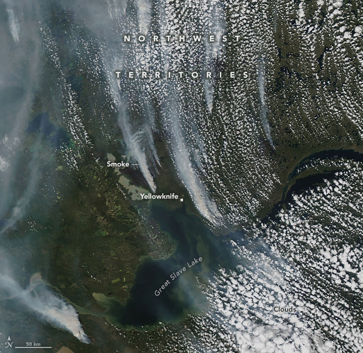
Image: NASA
Based on data from the Canadian Interagency Forest Fire Centre, there are 1037 active fires in Canada: 652 are out of control, 161 are being held in place, and 224 are under control as of August 23. Many of these fires were caused by lightning; however, with above-average temperatures this year and dry conditions, wildfires have been breaking out in Canada since May.
The Federal Aviation Administration (FAA) has released an implementation plan outlining the steps it and others will need to take to enable advanced air mobility (AAM) operations safely. The plan, called Innovate28, includes various components and a timeline for their implementation to hopefully be completed by 2028.
This plan serves as a foundation for making entry into service routine and predictable by maximizing the use of existing procedures and infrastructure. It addresses how the agency and partners will certify aircraft and pilots, manage airspace access, ensure pilot training, develop infrastructure, maintain security and engage communities.
The plan also includes a planning guide that can be applied to any site, laying out key integration objectives and sequences.
Among the entities that play a role in this plan include: the FAA; the advanced air mobility industry; labor partners, NASA; United States Department of Homeland Security; United States Department of Energy; power industry; and state, local and tribal communities.
Pilots will be able to fly the new advanced mobility aircraft to and from multiple locations at the sites, using predetermined flight schedules with pilots aboard.
Advanced air mobility aircraft likely will operate up to 4,000 feet altitude in urban and metropolitan areas, using existing or modified low altitude visual flight rules (VFR) routes where possible within controlled Class B and C airspace around major airports.
Infrastructure
Operators, manufacturers, state and local governments, and other stakeholders will be responsible for planning, developing and enabling heliport/vertiport infrastructure.
Advanced air mobility will initially operate at existing heliports, commercial service airports and general aviation airports. Modifications may be necessary to install charging stations, parking zones and taxiing space.
Power Grid
The electrical power grid may require upgrades to serve advanced air mobility operations.
The FAA has an interagency agreement with the Department of Energy’s National Renewable Energy Lab to determine how aircraft electrification affects a vertiport, heliport or airport’s electrical grid.
Security
The Department of Homeland Security will determine what type of security is necessary.
The Transportation Security Administration and FAA are evaluating the need for expanded cybersecurity requirements due to the use of advanced technology and operational protocols.
Environment
The FAA will consider the environmental impacts of advanced air mobility operations, including factors such as noise, air quality, visual disturbances and disruption to wildlife.
Community Engagement
The FAA will engage with airports, and local, state, and tribal communities to better understand community concerns about advanced air mobility operations, including noise and mitigations.
Many other stakeholders, such as advanced air mobility operators and airport and vertiport operators will have important roles in community engagement.
The U.S. government has visibly and physically conveyed its interest in getting air taxis into operation, through a visit of 70 people — attached to the newly formed Advanced Air Mobility (AAM) Coordination group — to Archer Aviation. The group talked with the executives of the company developing the “Midnight’ air-taxi aircraft and watched a flight test.
The AAM group includes members from leading government agencies concerned with making and keeping this segment of aviation successful, including the Federal Aviation Administration (FAA), the Department of Transportation (DOT), the National Aeronautics and Space Administration (NASA), the Department of Defense (DOD) and other agencies.
AAM group visits Archer Aviation. (Image: Archer Aviation)
Gathering the views of Archer and other electric vertical takeoff and landing (eVTOL) developer executives should be an essential part of the AAM group’s information collection task. And while it’s great to see that the interagency group has every intention of promoting the AAM concept of air taxis, it would perhaps be better if the group also had access to representatives of manufacturers, developers, and those with UAS experience. It’s clear that we need to start by spreading the word, but also by including people in the group who have dedicated themselves to bringing these capabilities to market — that may make the process more efficient.
Along the way, it may also help to understand that the processes we have used in the past to get airframes like this into passenger carrying operations might not work well with this new industry. It’s understandable that it should take a lengthy period to assess, verify, qualify and certify such vehicles in the name of safety, but if companies run out of cash and fold in the interim — which is highly likely with this “start-up industry” — then shouldn’t we be looking for a better way to get these guys off the ground?
No one wants safety to be sacrificed, but could there be some way to streamline, speed up, or simplify the process without skipping essential steps — a way to get new technology into use before it’s obsolete, or a lack of start-up money dooms its progress? The forecast for the economy in the near future is in the billions of dollars. So, providing funding to improve the current processes does make sense. DOD has started to put serious effort into speeding up its acquisition process and has empowered the Defense Innovation Unit (DIU) to find quicker ways to bring commercial technologies into defense.
The processes used to bring new technologies into use are tried and proven, but they are lengthy. In defense, if our opposition can field things quicker than we do, they have an edge in strategy, tactics and a higher probability of winning in battle. These countries are using the same approaches in the commercial world too, and we need to be wary that they may also have a greater chance of winning the “economic war.”
Nevertheless, Archer in California and others such as Joby, also in California, and Liliam in Germany, plod on through varying stages of FAA and European Union Aviation Safety Agency (EASA) certification paths. An example of the effort that a company has been required to put into fulfilling the requirements of a certification agency is that of Lilium, which first applied for its Design Organization Approval (DOA) in 2017, is still churning through the qualification efforts and does not expect approval until 2025. Of course, the answer is “Don’t get on the certification ‘hamster-wheel’ unless you can stand the journey.” However, we do want these systems and vehicles to make it in order to overcome some of the traffic nightmare that we are living through in our major cities and to contribute to the growth in the economy.
Meanwhile, the great hope (even expectation) of the “flying car” is being kept alive by Doroni in Miami with its two seat H1 eVTOL. Having largely burnt through its $3.6 million StartEngine launch money, Doroni is looking for its second round of funding to build more prototypes and join the certification race. However, other single seat eVTOL flying cars have taken the easier route to certify under the FAA Ultralight category.
Doroni H1 prototype. (Image: Doroni)
The H1 has semi-autonomous capability, which Doroni claims will make its eVTOL easy to fly, and allow general sales to any car driver. With air bags, an aerodynamic fuselage — which generates lift — 10 independent propulsion systems (four double prop ducted fans and two forward thrust props), an airframe that can behave as a parachute and “dissipate energy” in case of a crash, and landing gear, the H1 also has multiple independent batteries — all aimed at safety, which will help make it through certification verification. So, if you happen to have the $250,000 proposed sale price and are willing to wait on the completion of FAA certification, you could own your own “flying car.”
Doroni just announced that they have already made 50 test flights within their manufacturing facility along that test and qualification road.
Meanwhile, Ryse Aerotech in Ohio, recently demonstrated a manned test flight of its single seat Recon eVTOL — billed as an aid to farmers, with a top speed around 58 mph, a range of about 25 miles and with the right FAA clearance it could even reach an altitude of 700 ft — an airborne ATV for inspecting crops and the like.
Recon manned test flight in June 2023. (Image: Ryse Aerotech)
The path to market that Ryse has selected, however, should see more vehicles in earlier use than Doroni’s H1. All you may need is a driver’s license to take off in a Recon because it’s qualified as an Ultralight craft — just buy and fly. Beware, you cannot fly anywhere near an airport or after dark. FAA has restrictions on Ultralight craft.
So, progress on the semi-autonomous “flying-car” front and a plea to consider the economic benefits and to look to how to improve the efficiency of the existing certification process — not a request to cut corners, rather a request to speed up the processes and save this start-up industry before it goes broke.
“Since February 2022, there has been an increase in jamming and/or possible spoofing of GNSS. This issue particularly affects the geographical areas surrounding conflict zones but is also present in the eastern Mediterranean, Baltic Sea and Arctic area,” the European Union Aviation Safety Agency stated in a Feb. 17 safety information bulletin.
On April 4, the United Kingdom’s Civil Aviation Authority followed with its own advisory adding that, in addition to the year-over-year increase, interference has intensified in recent months citing the same geographic areas of concern.
Both advisories list impacts to aircraft that include:
loss of ability to use GNSS for waypoint navigation
loss of area navigation (RNAV) approach capability
inability to conduct or maintain Required Navigation Performance (RNP) operations, including RNP and RNP Authorization Required (RNP AR) approaches
triggering of terrain warnings, possibly with pull up commands
inconsistent aircraft position on the navigation display
loss of automatic dependent surveillance-broadcast (ADS-B), wind shear, terrain and surface functionalities
failure or degradation of a variety of air traffic management service and aircraft systems that use GNSS as a time reference
potential airspace infringements and/or route deviations due to GNSS degradation.
Airspace infringement can be a real concern, especially in conflict zones or near belligerent nations.
GPS was first authorized for civil use because of just such an incident. In 1983, a Korean airliner accidentally trespassed into Soviet airspace and was shot down. Despite the fact that the GPS constellation had not yet been declared fully operational, in September of that year President Ronald Regan authorized its use in civil applications to help avoid similar tragedies in the future.
GPS-based navigation for aircraft was subsequently found to be so efficient and successful that the Federal Aviation Administration (FAA) planned to eliminate all the terrestrial navigation beacons it maintains for air traffic and rely entirely upon GPS. Despite a 2001 report from the U.S. Department of Transportation’s Volpe Center cautioning against such an action, this plan was not abandoned until several years later when an aircraft crossing the Atlantic lost GPS reception.
In recent years, aviation industry concerns about interference with GPS and other GNSS signals have intensified. These concerns have even included planned and announced military exercises that cause interference. Aviation industry groups have complained that the exercises disrupt and are too costly to their operations.
Safety of life has also been a concern.
In 2019 a commercial passenger aircraft was nearly lost to GPS interference in Sun Valley, Idaho. Flying a GPS-based approach through the mountains to the airport, low-level interference caused the aircraft to deviate from its course. In the words of the safety report filed with NASA, had a sharp-eyed radar controller hundreds of miles away not spotted the problem and intervened, “…that flight crew and the passengers would be dead, I have no doubt.”
This incident was cited by the International Air Transport Association (IATA) in a filing later that year urging international action. Along with other groups, it pressed the U.N.’s International Civil Aviation Organization (ICAO) concerning “An Urgent Need to Address Harmful Interferences with GNSS.” In 2020, ICAO issued a letter to all member states recommending action.
Similar concerns have been expressed by other international bodies as well.
In 2021 a EUROCONTROL seminar said that there had been a 2,000% increase in GNSS RFI incidents since 2018 as measured by voluntary incident reporting. Also, that 38.5% of European en-route traffic operated in regions regularly affected by interference.
The International Telecommunications Union, the U.N. body responsible for coordinating spectrum use, issued its own concern and warning in 2022. It cited more than 10,000 aviation-related incidents the previous year and, like ICAO, urged member states to take action to prevent such occurrences.
While interference with GNSS signals is unquestionably a concern for commercial aircraft, it is perhaps even more of a safety risk for smaller, general aviation users.
The only electronic navigation aids in many of these aircraft are consumer-grade GPS receivers. Since these are not certified by the FAA, they are only officially authorized for use to help pilots maintain “situational awareness” while they fly using visual reference with the ground. Interference with GNSS signals can cause disorientation and could result in aircraft becoming lost, running out of fuel, or straying into prohibited areas.
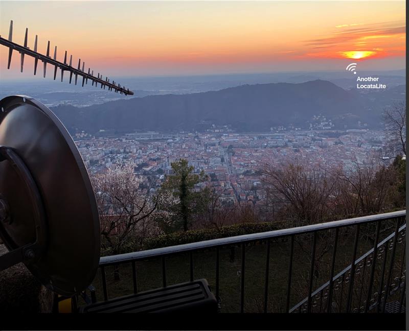
Locata dish antenna pointed back to EU’s JRC, 44 km away, just under the setting sun. The Yagi antenna above is pointed to a cell tower in Como and used to connect the system for remote control and data logging. Image: Locata
A new European Commission (EC) Technical Report, published after exhaustive and completely independent testing of several candidate A-PNT (Alternative Positioning, Navigation, and Timing) technologies, confirms that Locata has demonstrated positioning and timing performance across every test environment, delivering:
cm-level positioning accuracy in all tests, indoor and outdoor, under static and kinematic conditions
picosecond-level time transfer using Locata’s proprietary TimeLoc technology, over multiple media types including RF over distances of more than 105 kilometres and over fibreoptic and/or coaxial cables, without requiring satellites or atomic clocks.
The rigorous scientific test campaign was conducted over a period of eight months by experts from the EC’s Joint Research Centre (JRC) in Italy. Its purpose was to establish the foundations for European navigation and timing policy, including the upcoming European radio navigation plan, in the context of growing concerns about the single-point-of-failure that GPS and other Global Navigation Satellite Systems (GNSS) pose.
According to Locata, their validated capabilities promise to open previously unattainable, satellite-free A-PNT performance for autonomous vehicles, logistics, indoor positioning, critical national infrastructure, and aviation, as well as better levels of synchronization to improve mobile phone and digital data networks.
Locata’s products have been deployed commercially for a decade, delivering cm-level positioning (via sales and IP licenses) to globally recognized partners, including systems now certified for safety-of-life level operation of autonomous vehicles. Prominent government customers include NASA and the United States Air Force, which runs a large Locata network that covers more than 6,500 sq km for aviation use when GPS is being jammed or spoofed.
This performance evaluation assessment was run under a globally-open tender launched by the EC’s Directorate-General for Defence Industry and Space (DEFIS). The tender sought applications from around the world, from every potential candidate claiming they could provide “an alternative to GNSS-based PNT.” More than 30 companies applied, and this number was then down-selected by an expert panel to the seven technologies that were, in the end, independently evaluated. Locata was the only technology that was granted two contract slots, and the only technology that completed every timing and positioning test, in every indoor and outdoor environment, sought by the EU.
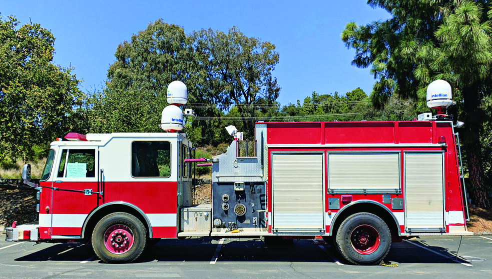
NASA-JPL prototype of POINTER base units on a first responder vehicle. The magneto-quasistatic fields they generate can be detected through walls, where legacy indoor positioning technologies fail. (Image: Jet Propulsion Laboratory)
A tragedy in 1999 spurred development of an entirely new type of positioning and location technology. “This project started with the Worchester, Massachusetts, warehouse fire,” said William Stout, program manager for the Department of Homeland Security (DHS) Science and Technology Directorate (S&T). “Six firefighters went in to clear an abandoned warehouse that was on fire to make sure there wasn’t anybody in there, and they got trapped. The team couldn’t find them because they had no idea where they were, and they ended up perishing.
That is what got DHS started with developing a first responder location tracking technology, Stout said.
“Over the years from that point on, we investigated many different technologies. My predecessor referred to most of these as ‘cocktail solutions’ because they would try to merge different types of technologies — for example, GPS and inertial — but none of these panned out.”
Enter Magnetoquasistatics Research
This lack of progress changed in 2012 when they connected with Darmindra Arumugam, group supervisor, senior research technologist and program manager at NASA’s Jet Propulsion Laboratory (JPL). Caltech manages JPL for NASA. In a complete departure from traditional radio signal-based positioning technologies, Arumugam and his team had been researching magnetoquasistatics (M/QS). This is the foundation for the POINTER System.
The system consists of fixed or portable transmitters, for instance, a base unit and controller that can be mounted on a first responder vehicle outside of a building. The first responders carry a small receiver that the base can locate with two characteristics: the field’s strength (for ranging) and its unique pattern (for lack of a better term) for direction (receivers send position info back to the controller via ISM band LoRa). The controller registers and displays the position of each receiver.
Why Magnetic Fields?
Ranging can be done in many modes, Arumugam said, and not all are based on just the amplitude of the propagating wave. With traditional radio signal ranging, to compute a precise position, techniques mostly use multiple sources of signals, for trilateration or multilateration, as GNSS does. However, signals can be perturbed by objects in their path, or experience multipath (signals bouncing off objects), which is a pronounced challenge for indoor environments.
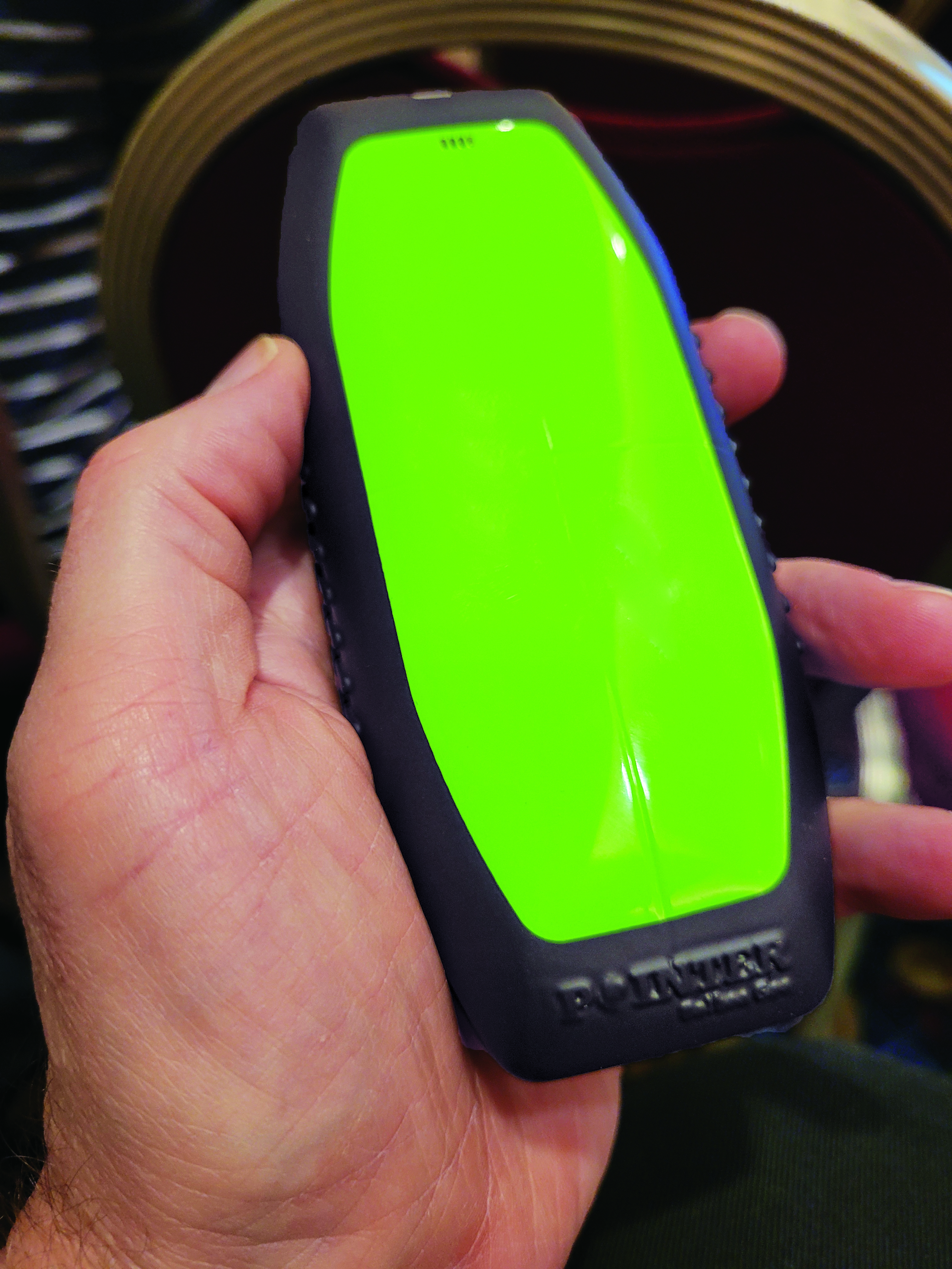
The portable POINTER receivers can be clipped by first responders to their belt, harness, or personal protective equipment, reporting their position in a building, and viewable by an incident commander on a laptop. (Image: Gavin Schrock)
POINTER does not employ radio signals in the fashion of traditional ranging solutions such as GNSS, ultra-wide band (UWB), and various beacon systems for indoor positioning. However, Arumugam said POINTER does generate a radio signal.
“The key difference is that we are detecting the field in a regime where there is no radio propagation mode. Therefore, it is more accurate to refer to this as a quasi-static field, as opposed to a radio propagating wave,” Arumugam said.
Arumugam said Earth’s magnetic field is a good example of this. “It penetrates structures very well, we can measure it 100 kilometers beneath the surface, far above the surface, inside buildings, underwater and so on,” he said. “POINTER uses the kind of the features that you see in Earth’s magnetic field — we are generating quasi-static magnetic fields.
“The term quasi-static highlights the fact that we are trying to keep the physics of the field stationary for all purposes but apply some slow time variation so that it’s really quasi-static to optimize the benefits from both,” Arumugam said. “We get the best of the behaviors of static fields in terms of penetration and non-line-of-sight capability, but also optimize for signal-to-noise by making this a quasi-static signal as opposed to a perfectly static one.”
JPL developed for DHS S&T prototypes that the two organizations tested jointly. Both transmitters and receivers employ an array of three coils, oriented at right angles for x, y and z. The resultant transmitted field carries distinct patterns from these three axes. Distance is detected from field strength, and direction is determined by detecting the pattern of the field relative to the three axes. A key strength of POINTER is that it can achieve ranging and direction from a single base station.
However, Arumugam noted that multiple bases could be beneficial for certain situations.
“The technique as originally developed requires only one transmitter. However, we find that there’s only so much you can get out of a magnetic field, and certain types of structures and materials will perturb that field, causing error.” The second transmitter is not only a backup, but it also helps reduce errors.
POINTER
Geolocation Inc. was spun out from Caltech to license and commercialize POINTER, said Joseph Boystack, executive chairman and co-founder. “We stepped in and executed an exclusive worldwide license for every field of use on this technology in late 2020 from JPL. They had established a proof of concept, and begun testing the technology in the field.”
For the initial commercial version, Balboa Geo made significant improvements over the JPL prototype system. It developed two transmitters that can be deployed on a fixed-mounted basis (buildings, vehicles, ships, etc.) or be portable housed inside a ruggedized, military specification (MIL-STD) case, with a built-in dual antenna GNSS receiver (to position and orient the transmitter).
“If you have an incident involving first responders, military or industrial applications, these remotely configured transmitters can be quickly and easily deployed,” Boystack said. “Also very important, because it only needs to depend on the field generated by the transmitter, we’re not dependent upon other large, fixed infrastructure such as satellites, towers or beacons, and can work in degraded environments where most other position, navigation and timing techniques fail.”
The self-contained receivers are only about the size of a smartphone. The orientation of the receiver is important to determine the “xyz” axis relative to the generated field, thus providing highly accurate three-dimensional position and navigation data. For instance, Balboa Geo’s receiver can be clipped to a first responder’s belt, harness, or personal protective equipment. Similarly, for fixed assets or moving assets such as warehouse systems or robotics, the orientation would be known.
The POINTER system will generate real-time data that can be easily visualized at the job site or event by the incident commander or manager on a laptop or a tablet. The data is interoperable and may be ingested in third-party software applications.
This version meets DHS STS’s original expectations, and subsequent versions will build on it. “S&T relies on experienced emergency response and preparedness professionals to guide our research and development. The First Responder Resource Group is made up of hundreds of state and local volunteers,” Stout said. “We initially looked at tracking firefighters in some of the most common scenarios: two-story house fires.”
While POINTER technology has the potential for much longer ranges and precisions, the current version, Arumugam said, certainly meets the specifications for this initial application. “The current systems can operate up to about 75 meters in range from the transmitter. So, if a transmitter is placed about 10 meters outside the building, say on the fire truck, you can penetrate up to about 65 meters inside the structure. That covers many one, two, maybe three-story structures. Position accuracies can be one meter or less. In principle, you could get to a centimeter, but that’s not required for this technology to be the lifesaver it presently needs to be.”
JPL continues research and development to extend range and increase precision to enable DHS S&T to deploy this technology to ever broader safety-of-life applications where legacy technologies fall short or are completely impractical. Balboa Geo is conducting field and lab tests for many more applications across multiple industries including energy, construction, maritime, mining, the internet of things and more.
When the U.S. Air Force shot down a Chinese balloon flying at 60,000 ft (11.4 miles) on Feb. 4, the incident raised many questions about international security, international law, U.S.-China relations and technology. Among them, where is the end of a nation’s airspace — the portion of atmosphere it controls above its territory? Its horizontal boundary corresponds to that of its land border and territorial waters, which extend 12 miles out from its coastline. However, there is no international agreement on the vertical boundary.
The 1967 Outer Space Treaty — to which the United States is a party and which bans “appropriation” of outer space by any nation — omits a definition of “outer space” because none of the major powers wanted to limit their own freedom of action in space. At a United Nations meeting in Vienna in 2001, the U.S. delegation said, “Our position continues to be that defining or delimiting outer space is not necessary.”
The United Nations has historically accepted as the boundary of space the Kármán line, at an altitude of 62 miles above mean sea level. It roughly marks the altitude where traditional aircraft cannot effectively fly using lift generated by Earth’s atmosphere, because the air there is just too thin. The Fédération Aéronautique Internationale agrees with this definition.
Some countries have adopted a definition for their own legal purposes, usually based on either the Kármán line or on the altitude at which orbital flight is possible without utilizing atmospheric lift. As a courtesy, a state launching a space vehicle that will traverse another state’s territory during its sub-orbital flight will notify the overflight state.
The U.S. military and NASA on the other hand, define space to begin at 50 miles above Earth’s surface. “Pilots, mission specialists, and civilians who cross this boundary are officially deemed astronauts,” according to the U.S. Department of Commerce’s National Environmental Satellite Data and Information Service.
Escaping Earth’s atmosphere entirely is another story. It requires traveling at least 600 miles, to its outermost layer, where violent solar winds have greater sway than air. If that were the definition of space, however, the Space Shuttle (which orbited up to 200 miles up), the International Space Station (205 miles to 270 miles), active Earth observation satellites (280 miles to 500 miles), some of the National Oceanic and Atmospheric Administration’ s polar-orbiting satellites (540 miles) and most scientific satellites, including nearly all of NASA’s Earth Observing System fleet, would not be considered spacecraft! Lower orbits have significant air-drag, which requires frequent orbit re-boost maneuvers.
There’s no question that GPS satellites, orbiting at an altitude of about 12,550 miles, are in space. That is why they are acquired, sustained, and operated by the U.S. Space Force (USSF), established in December 2019 as the newest branch of the U.S. armed forces. Its mission is to organize, train and equip space forces to protect U.S. and allied interests in space and provide space capabilities to the joint force. As the USSF grows, we’ll hear more about it.
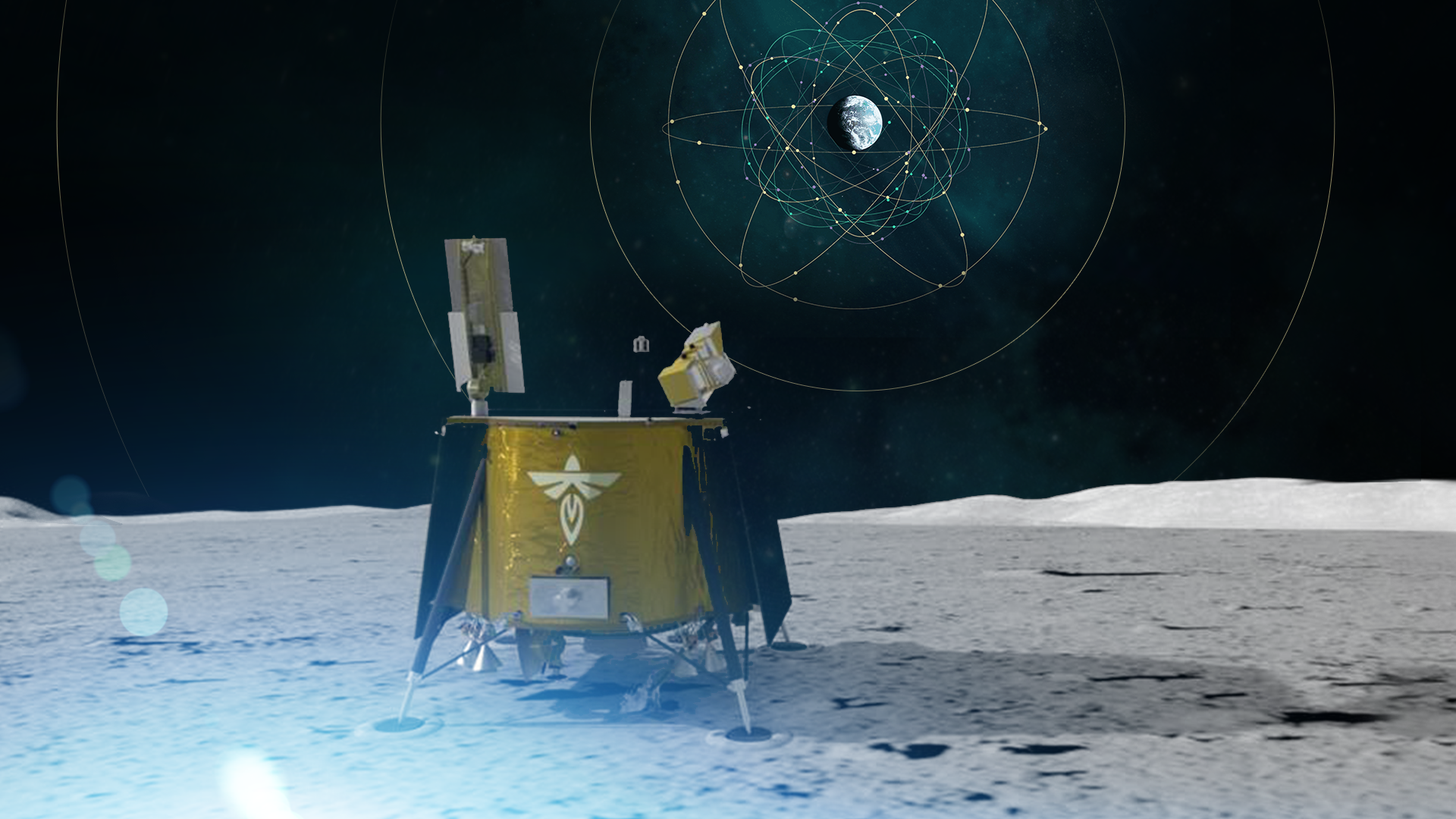
As a part of the NASA Commercial Lunar Payload Services initiative, Firefly Aerospace will land the Blue Ghost lander on the lunar surface in 2024. Onboard, the Lunar GNSS Receiver Experiment (LuGRE) payload will determine whether signals from two GNSS constellations can reach the lander and provide precise navigation on the moon for future missions.
During a 12-day mission in the moon’s Mare Crisium basin, LuGRE will obtain the first GNSS fix on the lunar surface and receive signals from both GPS and Galileo. The LuGRE payload is managed by NASA’s Space Communications and Navigation program office.
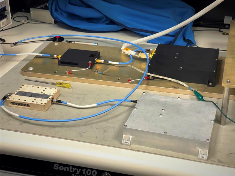
This payload is a collaborative effort between NASA and the Italian Space Agency to expand the capabilities of Earth-based navigation systems. Navigation engineers at NASA’s Goddard Space Flight Center in Greenbelt, Maryland, have been testing the payload’s GNSS receiver and low noise amplifier. The receiver was developed and built by the Italian company Qascom.
These components will be critical to LuGRE obtaining signals from the GPS and Galileo satellites. To prepare for operating on the moon, NASA engineers used a GNSS simulator to test and configure the payload to accurately receive and process the signals.
The LuGRE payload GNSS receiver and low noise amplifier. (Image: NASA/Dave Ryan)
The Goddard team delivered in February the flight hardware to Firefly Aerospace in Cedar Park, Texas, where it will be integrated into the Blue Ghost lander.
Astronauts and rovers traversing the lunar surface will need precise location and tracking data for their exploration endeavors. The data gathered from the LuGRE payload will be used to further develop GNSS-based navigation systems for future missions to the moon.
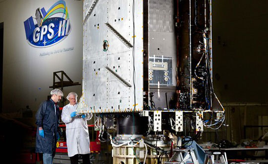
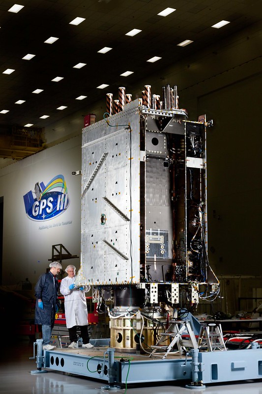
GPS III Space Vehicle 06 (SV06) reached Operational Acceptance on Jan. 31 according to the Space Systems Command (SSC) of the United States Space Force. SV06 was launched on a SpaceX Falcon 9 Block 5 vehicle on Jan. 18.
SSC also transferred Satellite Control Authority (SCA) of SV06 to the 2nd Space Operations Squadron at Schriever Space Force Base, Colorado. GPS III SV06 joins the GPS PNT constellation of 31 operational satellites.
This is the first time SCA and Operational Acceptance has occurred on the same day enabling faster delivery for users. SSC’s Military and Communication positioning, navigation and timing (PNT) enterprise collaborated with the U.S. government acquisition team, industry and space operators on the achievement.
“The Operational Acceptance of GPS III SV06 further contributes to SSC’s ongoing modernization efforts, as it brings our overall suite of capabilities ever closer to our target dates for deployment to the warfighter,” said Col. Heather J. Anderson, transition director within SSC’s PNT directorate. “GPS III SV06 will be set healthy to all global users in February 2023.”
The first-stage booster used in the SV06 launch previously sent the NASA Crew-5 mission to the International Space Station on Oct. 5, 2022.
Nearly 50 years ago, in December 1973, the Defense Systems Acquisition Review Council approved the Navstar Global Positioning System for entry into Phase I of development. Since then, through its development, deployment and continuing modernization, GPS has grown into a complex program. It is operated by the Department of Defense based on legislation from Congress, executive orders from the White House, and policies established jointly with the Department of Transportation. It supports U.S. military missions as well as myriad scientific, commercial and consumer applications around the planet. Of course, the last category, with its billions of users, now dwarfs all the other ones combined.
The GPS program, with an annual budget of nearly $2 billion and no user fees, is a gift from U.S. taxpayers to the world. It has staff in Washington, D.C.; at the Pentagon in Arlington, Virginia; at Schriever Space Force Base, Colorado; at the Space Systems Command at Los Angeles Air Force Base, California; at Cape Canaveral, Florida; at the U.S. Coast Guard Navigation Center in Alexandria, Virginia; and at GPS ground antennas in additional locations around the world. From the White House to Congress to aerospace companies, from military officers to civilian civil servants, from policy makers to engineers, from the East Coast to the West Coast to remote islands in the Pacific, Indian and Atlantic Oceans, GPS is a vast enterprise — most of which is little known even to people in the industry and virtually unknown to the public.
The Global Positioning System is a vast and mostly unknown enterprise. This section — the first in an occasional series of authoritative reference pieces in this magazine — aims to clarify who does what to maintain GPS as a fantastic global utility. The relevant missions of agencies or units are in italics.
After I researched and drafted the piece, I asked the experts listed below to review it and provide corrections and additions. While grateful for their substantial feedback, I take sole responsibility for any remaining errors or omissions.
Thank you to the following experts:
Harold W. Martin III, Director, Space-Based Positioning, Navigation & Timing, National Coordination Office
Michael J. Dunn, Capability Area Integrator for PNT, Space Systems Command, United States Space Force
Lt. Col. Robert O. Wray, Commander, 2nd Space Operations Squadron, United States Space Force
Scott R. Calhoun, Commanding Officer, Navigation Center, United States Coast Guard
Paul Benshoof, Technical Director, 746th Test Squadron (AFMC), Central Inertial and GPS Test Facility
Bernard Gruber, Senior Director, Northrop Grumman
Please return to this page periodically to read corrections and updates to this special section. If you spot any significant inaccuracies or omissions, please bring them to my attention by writing to me at [email protected].