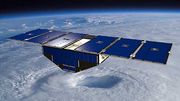
Artist’s concept of one of the eight CYGNSS satellites in orbit. (Image: NASA/University of Michigan)
Since Nov. 26, NASA’s Cyclone Global Navigation Satellite System (CYGNSS) team has not been able to make contact with one of the eight CYGNSS spacecraft, FM06.
The team is still working to acquire a signal and establish a connection.
The other seven spacecraft continue to operate normally and have been collecting science measurements since the FM06 anomaly.
CYGNSS is a constellation of eight small satellites taking measurements of ocean surface winds in and near the eye of the storm throughout the lifecycle of tropical cyclones, typhoons and hurricanes.
If the team isn’t able to reestablish contact, loss of the FM06 satellite would primarily affect the constellation’s spatial coverage. However, the CYGNSS constellation can continue to meet its scientific requirements and objectives.
CYGNSS was launched Dec. 15, 2016, and completed its prime mission science objectives on March 19, 2019. It has been operating in extended mission status since then.
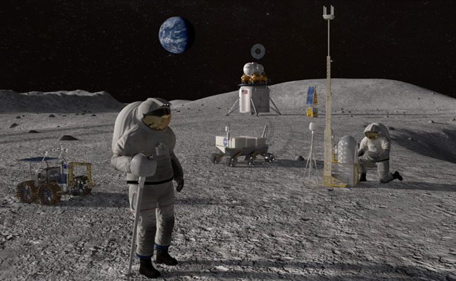
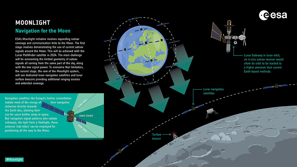
The European Space Agency (ESA) is looking for companies interested in helping create a constellation of lunar satellites to connect and guide missions to the Moon. Creating lasting telecommunications and navigation links with the Moon will enable sustainable space exploration for the hundreds of lunar missions that are due to launch within the next few decades, ESA stated.
The companies would provide telecommunications and navigation services to these lunar missions, under its Moonlight initiative.
ESA is completing two studies with two consortia of space companies based in Europe that assess the business case and the technical solutions for building and operating a constellation of lunar satellites. ESA is asking any space firms to indicate whether they would like to become involved in the ambitious project — or simply to develop lunar telecommunication and navigation technologies and products. The deadline is Oct. 28.
Artist’s rendering: NASA
On Sept. 19, ESA Director General Josef Aschbacher and NASA Administrator Bill Nelson signed a joint statement on lunar exploration cooperation at the International Astronautical Congress in Paris.
The lunar Gateway will be an outpost in orbit around the Moon. It will serve as the staging point for both robotic and crewed exploration of the lunar south pole.
ESA’s European Service Modules will power all Artemis Orion spacecraft to the Moon and back. ESA will also provide refueling elements for Gateway and a communications module that will pave the way for Moonlight.
ESA has already initiated the Lunar Pathfinder project to provide initial communications services to early lunar missions, which will also help to prepare for the next stage with Moonlight. The Lunar Pathfinder will also include a navigation payload demonstrator, which will allow positioning in lunar orbit using GPS and Galileo systems for the first time, and is due to launch in 2025.
Space companies in Europe and Canada will be invited to tender for the initial Moonlight work in December.
By Alex Damato, Acting Executive Director, GPS Innovation Alliance
Alex Damato
It can be easy to take GPS for granted as the average driver and smartphone user continues to enjoy convenience, entertainment and navigation from this technology, enhancing nearly every part of our daily lives. While we may not enjoy its benefits every day, one important use case keeps us and our environment safer: GPS has become a vital part of modern emergency response.
Many Americans across the nation are preparing for the impending hurricane season or the threat of other natural disasters, such as wildfires and earthquakes. GPS will play a critical role in recovery and response efforts. When natural disasters occur, accurate and actionable location information helps save lives and restore critical infrastructure as quickly as possible.
GPS has fundamentally improved access to information that can help the public prepare for these natural disasters, rather than waiting for them to strike. This information is more critical than ever. For example, California’s Oak fire spread to almost 20,000 acres and is part of a larger trend in California that has destroyed 14,700 buildings and killed 36 people over the past two years. Farther north, 530 wildfires in Alaska burned areas larger than the state of Connecticut in the state’s worst fire season in recent history.
In addition to helping the public face natural disasters, GPS helps firefighters plan their operations more efficiently and enables them to receive real-time information on the location of the wildfires they are fighting. With real-time mapping, planning and operations, fire chiefs can respond immediately to areas where wildfires are dangerously advancing.
In turn, GPS protects our first responders by preventing firefighters from getting caught in unpredictable fires they would have otherwise not known were heading their way.
Firefighters use IGNIS drones to help prevent wildfires from starting or safely contain them with backburns. IGNIS relies on GPS for tracking, safety and control, which in turn helps firefighters avoid the dangers associated with being near prescribed burns. Without GPS, resources to help firefighters would not be deployed as efficiently — wildfires could spread even more quickly as a result, causing even more damage to our homes and infrastructure.
Beyond wildfires, GPS technology is critical to emergency response and weather safety. GPS data allow emergency responders to better locate callers and reduce the incidence of misrouting to outside jurisdictions. Using GPS data, a caller can be located in close proximity to his or her actual location. By reducing rates of misrouting and accurately pinpointing emergency locations, GPS helps reduce response time by taking away the need to reroute calls and search for callers’ locations.
In a recent experiment, NASA-commissioned researchers used GPS signals to better predict a hurricane’s maximum wind speed, which could help federal agencies and forecasters better predict the danger of hurricanes and provide more actionable information to determine whether to issue evacuation orders.
The GPS Innovation Alliance (GPSIA) is proud to support the role of GPS as a critical enabling technology for public safety, disaster response and relief efforts. With GPS, precise real-time location information is at the fingertips of both consumers and first responders from pre-disaster planning efforts to post-disaster recovery. While GPS has already fundamentally improved modern emergency response systems, GPSIA will continue to advocate for the continued growth of these lifesaving GPS-enabled technologies and applications through rigorously developed technical rules, interference protections, and a predictable spectrum environment.
Many of us have grown accustomed to the ease of GPS-enabled technologies, from smartphone to fitness trackers. At GPSIA, we’re also particularly proud of the role GPS plays in the many other life-saving ways the technology is being used and are committed to continuing this critical work.
The 62nd meeting of the U.S. government’s Civil GPS Service Interface Committee (CGSIC) will be held Sept. 19–20 in the Hyatt Regency Denver at the Colorado Convention Center, before the annual ION GNSS+ conference.
It will be hosted by the U.S. Department of Transportation (DOT) and the U.S. Coast Guard Navigation Center (NAVCEN). DOT serves as the civil lead for GPS and chairs the CGSIC in this capacity. NAVCEN is assigned duties as Deputy Chair and Executive Secretariat for the CGSIC.
On Sept. 19, the CGSIC subcommittees for Timing, International Information, and Survey, Mapping, and Geosciences will meet. A summary of these meetings will be presented to the CGSIC Plenary Session on Sept. 20.
Cordell DeLaPena, Program Executive Officer for Military Communications and PNT Space Systems Command
Keynote speaker for the plenary session is Cordell DeLaPena, program executive officer for Military Communications and Positioning, Navigation, and Timing, Space Systems Command, Los Angeles Air Force Base.
The agendas for the CGSIC subcommittee and plenary sessions will include presentations on the operational status and modernization of the GPS constellation of satellites, U.S. space-based positioning, navigation and timing (PNT) policy, GPS augmentation systems, and information related to U.S. engagement with other international GNSS as well as a variety of interesting applications of the use of GPS.
Several new briefings are part of the plenary session this year, including a presentation from NASA on the role of GPS in support of the next lunar mission. Also, the Department of Homeland Security will provide an update on the activities of the Office of Infrastructure Protection, Positioning, Navigation, and Timing Program Management Office.
This year’s meeting will be live-streamed over the internet. For those who are unable to travel, the meetings can be accessed with the links below.
The agenda for the meeting is available; all CGSIC presentations will be available there for viewing online shortly after the meeting ends. As a reminder, all CGSIC meetings are free and open to the public.
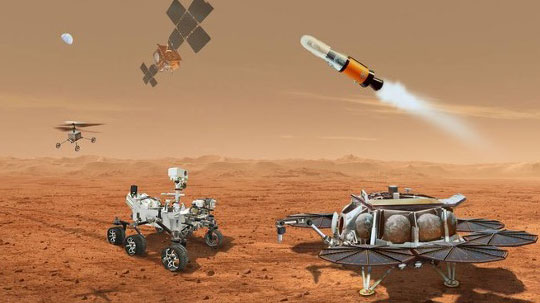
NASA and the European Space Agency (ESA) have been cooking up a way to get some of Mars back to Earth, so that samples can be analyzed in detail — just like the rocks the astronauts brought back during the Apollo missions, which gave us a deeper understanding of our Moon.
The Perseverance rover already on Mars has been seeking promising areas to investigate that might provide evidence of ancient past life, with the help of the Ingenuity helicopter drone. Recently, the two worked together to drive the rover to an old river delta, expected to be a prime location where such samples could be found.
The rover has been drilling and saving rock and dirt samples in onboard storage tubes. The difficulty is that getting them back to Earth requires another major undertaking.
Returning the Samples
Termed the “Sample Return Mission,” the two space agencies have been discussing for months how best to bring the samples back, and have now refined an approach. Given that Perseverance has been so good at the job it was given, the NASA/ESA team has decided that the rover should be used for the return mission in 2030 when things would be in operation on Mars. (We’re not sure if the warranty sticker on Perseverance will still be valid in 2030, but if past performance is an indication, all the rovers have significantly outlived their initial design lives.)
Its partner Ingenuity has graduated from proving it can fly in the thin Martian air to actually scouting routes for the large rover. Because Ingenuity has proven reliable and capable of traveling significant distances, NASA and ESA have decided that two new helicopter drones will become part of the return mission. They will be based on the successful Ingenuity design, but will be fitted with wheels, one on each of the four landing legs, to enable movement on the ground.
They will also be fitted with a device which is capable of picking up and carrying a sample tube. Since the prototype drone helicopter was designed to be as light as possible, this infers a substantial increase in lift capacity will be required. The original mission included a sample-collection rover, but this task will now be assigned to Perseverance, with the two sample-carrying helicopters acting as backup, if needed.
An earlier concept had the rover dropping sample canisters behind it as it progressed around the surface for subsequent pick up. This concept appears to have been shelved for the moment. Keeping the canisters onboard the rover throughout perhaps simplifies transfer to the return lander.
This NASA return sample concept illustration includes wheeled helicopters. (Image: NASA/JPL-Caltech)
The Mars Ascent Vehicle would then carry the samples into orbit, to a waiting Earth Return Obiter, where the samples would be transferred to a return system for onward transit and atmospheric re-entry to Earth. Some of these details are a little sketchy, but there sure are a lot of moving (autonomous, robotic?) parts. This, of course, means a lot of opportunities for something to go wrong. No doubt continuing refinement of the mission will reduce the risks. The Jet Propulsion Lab (JPL) and AeroVironment designed and built Ingenuity — they may face some challenges developing the successor helicopter drones.
Meanwhile, Here on Earth…
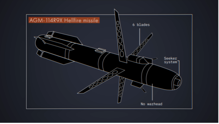
Drones led the news Aug. 1, when President Biden announced the killing of Ayman al-Zawahiri in Kabul, Afghanistan. Al-Zawahiri topped the U.S. 9/11 wanted list, and his removal was all about the offensive use of drones. Presumably fired from a General Atomics Reaper variant drone at quite some altitude, two Hellfire AGM-114R9X “knife bomb”missiles took out al-Zawahiri as he stood alone on the balcony of a home in Kabul.
This means that video/infrared from high altitude was sufficiently clear to determine that the man was alone on the balcony, presumably confirming information on the ground that his family was elsewhere. So long-distance, high-level authorization was then granted to fire on him in a foreign country now run by the Taliban.
Suspected damage at the al-Zawahiri house in Kabul. (Photo: Secunder Kermani/BBC News)
To minimize inadvertent casualties, the Hellfire R9X missile was used, which lacks explosive armaments. The weapon is a nasty piece of work, weighing ~100 lb with an inert payload, and fitted with six long knives that deploy before impact. This missile has previously been used in perhaps 11 other instances to take out terrorist individuals and minimize collateral damage.
Bladed R9X missile lacks a warhead (Image: Newsy/Bellingcat)
This is another instance of how the U.S. use of military drones has become less devastating, but is still very deadly to the specific target.
To Sum Up
We’ve taken a quick glimpse at how NASA and ESA are planning more drones for the surface of Mars, and a much more aggressive use of drones here on Earth.
Space Tech Expo Europe has opened its call for speakers for the free-to-attend conference to be held Nov. 15-17 in Bremen, Germany.
The conference will focus on the latest advancements in the European and global space industry, including space exploration, in-space manufacturing, launch, system development, market trends and more.
The conference will take place alongside the leading supplier trade show with hundreds of exhibitors showcasing the latest space technological advancements. The conference provides attendees with the knowledge on the latest developments in European space. Previous speaking companies include: OHB, NASA, ArianeGroup, Airbus Defence and Space, UK Space Agency, ESA and many more.
Proposals for speakers will be accepted through April 11, 2022. To submit a proposal or learn more about the event, please visit the Space Tech Expo Europe website.
Collaboration powers GPS and Galileo navigation experiment
By Danny Baird NASA’s Goddard Space Flight Center
As the Artemis missions journey to the Moon and NASA plans for the long voyage to Mars, new navigation capabilities will be key to science, discovery and human exploration.
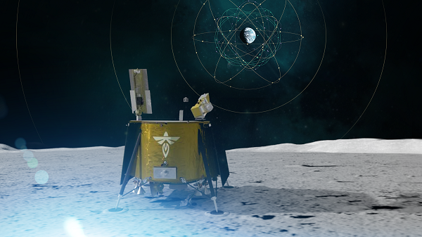
Through NASA’s Commercial Lunar Payload Services initiative, Firefly Aerospace of Cedar Park, Texas, will deliver an experimental payload to the Moon’s Mare Crisium basin. NASA’s Lunar GNSS Receiver Experiment (LuGRE) payload will test a powerful new lunar navigation capability using Earth’s GNSS signals at the Moon for the first time.
“In this case, we are pushing the envelope of what GNSS was intended to do — that is, expanding the reach of systems built to provide services to terrestrial, aviation, and maritime users to also include the fast growing space sector,” said J.J. Miller, deputy director of Policy and Strategic Communications for NASA’s Space Communications and Navigation (SCaN) program. “This will vastly improve the precision and resilience of what was available during the Apollo missions, and allow for more flexible equipage and operational scenarios.”
LuGRE — developed in partnership with the Italian Space Agency (ASI) – will receive signals from both GPS and Galileo, and use them to calculate the first-ever GNSS location fixes in transit to the Moon and on the lunar surface.
“Space missions close to Earth have long relied on GNSS for their navigation and timekeeping,” said Joel Parker, LuGRE principal investigator at NASA’s Goddard Space Flight Center in Greenbelt, Maryland. “In recent years, NASA and the international community have pushed the boundaries of what was considered possible by using these techniques in the Space Service Volume and beyond.”
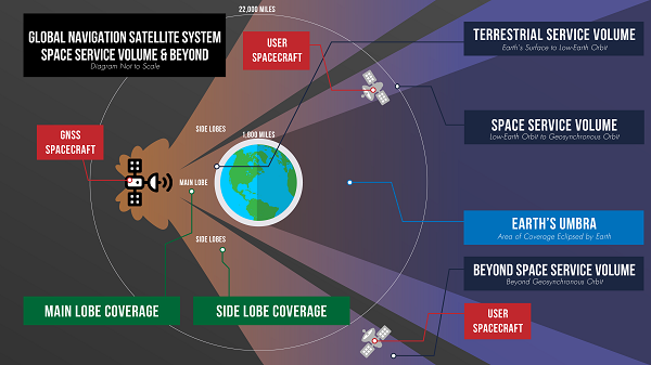
This graphic details the different areas of GNSS coverage. (Image: NASA/Danny Baird)
Missions in the GNSS Space Service Volume — from about 1,800 miles to 22,000 miles in altitude — receive signals that spill past Earth’s edge from GNSS satellites on the opposite side of the planet. The first Space Service Volume experiments occurred around the dawn of the new millennium. Since then, numerous missions in the Space Service Volume have reliably used GNSS to navigate.
In 2016, the NASA’s Magnetospheric Multiscale Mission (MMS) employed GPS operationally at a record-breaking 43,500 miles from Earth. Then, in 2019, MMS broke its own record by fixing its location with GPS at 116,300 miles from Earth — nearly halfway to the Moon.
At these extreme altitudes, missions need extremely sensitive GNSS receivers. The LuGRE mission will use a specialized weak-signal receiver developed by Qascom, an Italian company specializing in space cybersecurity and satellite navigation security solutions, and funded by ASI.
LuGRE teams are now testing the payload in preparation to deliver it for integration onto the Firefly “Blue Ghost” lander in November of this year. Launch is slated for no earlier than 2024 from Cape Canaveral, Florida, aboard a SpaceX Falcon 9 rocket.
During the multi-week flight to the Moon, LuGRE will collect GNSS signals and perform navigation experiments at different altitudes and in lunar orbit. After landing, LuGRE will deploy its antenna and begin 12 days of data collection, with the potential for extended mission operations. NASA and ASI will process and analyze data downlinked to Earth, and then share results publicly.
“LuGRE is the latest effort in a long line of missions designed to expand high-altitude GNSS capabilities,” said Fabio Dovis, LuGRE co-principal investigator, ASI. “We’ve developed a cutting-edge experiment that will serve as the foundation for operational GNSS systems at the Moon.”
The LuGRE mission seeks to spark further development of GNSS-based navigation capabilities near and on the Moon, even as NASA plans to begin using high-altitude GNSS operationally for future lunar missions. NASA and ASI will bring the results of this work forward to the space community through the International Committee on GNSS, a United Nations forum focused on ensuring the interoperability of GNSS signals. These capabilities are also a key stepping stone towards building LunaNet, an architecture that will unify cooperative networks into seamless lunar communications and navigation services.
Artistic rendering of LuGRE and the GNSS constellations. In reality, the Earth-based GNSS constellations take up less than 10 degrees in the sky, as seen from the Moon. (Image: NASA/Dave Ryan)
“The lunar deliveries we’re sourcing from commercial vendors are providing a number of innovative new technologies and opportunities to conduct experiments with affordable access to the lunar surface,” said Jay Jenkins, Commercial Lunar Payload Services Program executive. “LuGRE is one example of the progress that government and industry can make when united in their exploration objectives.”
Developing new uses of GNSS for emerging space operations is a priority for the SCaN program at NASA headquarters, as the lead organization responsible for implementing guidance from Space Policy Directive-7, which directs NASA to develop requirements for GPS support of space operations and science in higher orbits and beyond into cislunar space.
This month, we look at new applications that might interest even the most tech-savvy. From military Reaper unmanned vehicles being turned into civilian fire-fighters, through continuing drone flights on Mars, to e-scooters monitored by AI-system, the autonomous arena continues to grow.
Reaping Disaster-Response Benefits
The General Atomics Reaper unmanned aerial vehicle (UAV) is usually a weapon of war. Most of us picture them loaded with missiles to be fired on terrorist hideouts, with video of the impact appearing on the six-o’clock news. Soldiers in small control shacks guide these worldwide attacks, while politicians watch the outcomes remotely with their own direct TV coverage. This is how we tend to think of these destructive systems.
However, Reapers recently have been helping fight the huge fires devastating the California landscape — a more humanitarian, supportive role for a military asset.
General Atomics Reaper UAV on patrol and remote pilots (Photos: California Air National Guard)
The California Air National Guard (ANG) has been assisting firefighters for many years by using helicopters and fixed-wing aircraft to determine the intensity of large California fires and to plot their boundaries.
In the past 10 years, with the availability of large reconnaissance UAVs and assistance from the Federal Aviation Administration to develop and approve operational procedures, an approach has been formulated to employ Reapers, with the potential to reduce costs and greatly improve response times.
Having large UAVs at altitude in civilian airspace requires an accompanying chase plane to ensure safe operation. With proven onboard detect-and-avoid capability and visibility through crew monitoring, the chase aircraft only monitors the Reaper’s climb to operational altitude. Using infrared and video from onboard cameras, data is downlinked and post-processed to create fire maps. Artificial intelligence (AI) automates this procedure to provide incident commanders with a near-real-time situational overview.
Besides mapping the fire, the incident commander can keep track of firefighters on the ground and gain a clearer picture of the fire’s intensity, rate of growth and direction. With a high altitude view of the landscape, Reaper pilots also help determine the best evacuation routes. Video downlinks provide real-time fire dynamics to commanders and even to firefighters on the ground who carry handheld devices.
When equipped with long-range fuel tanks, Reapers can remain on task for up to 18 hours. The pilot and systems operator in their remote mission-control shack can hand over control to a new crew for such a long mission. The new crew can even be in a different location when it assumes control.
The experience gained in California regarding flight approvals, operations and use of data is being shared with remote UAV crews and emergency-response controllers in other U.S. jurisdictions as well as other countries. The procedures can be used not only for firefighting, but also for earthquake, flooding and hurricane response.
Our Martian Adventure
NASA has extended the mission on Mars of its Ingenuity UAV, which arrived on the planet attached to the belly of the Perseverance rover. The original mission was to establish that controlled flight on the planet’s surface was possible.
Ingenuity has now spent more than one year on the surface of Mars and has 21 flights under its belt. The diminutive copter has taken on an extended role of scouting out potential routes for its SUV-sized mother ship.
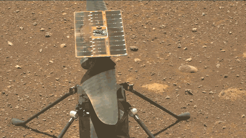
Integrity runs a “wiggle test” of its rotor blades prior to flight. (Photo: NASA/JPL-Caltech/ASU)
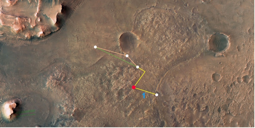
Ingenuity’s 21st flight is the first of at least three needed to transverse the Séítah region to reach its next base. From there, it will make flights to examine an old river delta. The whole relocation trip will cover about 1,150 feet as Integrity navigates around a large hill. While flying these investigative routes, the NASA team continues to gently push the drone’s capabilities to better understand improvements that can be applied to future Mars UAV designs.
Proposed route to reach river delta. (Image: NASA/JPL-Caltech/University of Arizona/USGS)
Once at the river delta, Ingenuity will encounter higher ground — up to 130 feet above the floor of the Jezero Crater, where it previously flew. The new area is expected to present significant obstacles: jagged cliffs, angled surfaces, rocky outcroppings and sand-filled traps. These obstacles could hamper the Perseverance rover or tip over the small drone on landing. But it’s also a place NASA thinks could harbor evidence of past life.
On arriving at the delta, Ingenuity’s first task will be to help decide which of two river channels Perseverance should take to climb to the delta. Data from the drone will also pick out science targets that Perseverance could investigate on the way. Once established in the delta region, NASA also hopes to fly Ingenuity to scout other features the rover might not be able to reach, but which might be accessible on future missions.
NASA has uploaded several upgrades to Ingenuity. They enabled higher, faster and longer flights and speed changes. The upgrades also have improved the drone’s perception of landing areas. Potential upgrades include adding terrain elevation maps and a hazard-avoidance capability for safer landing.
E-Scooters Adopt Pedestrian Defense
An outfit that rents e-scooters in more than 60 cities worldwide is adopting a “pedestrian defense” AI upgrade to prevent renters from abusing others around them and keep them riding within acceptable rules of operation.
LINK e-scooter. (Photo: Superpedestrian)
Previous efforts have only give riders visual and audio warnings that they should not enter a sidewalk. This new e-scooter active defense system slows the scooter to a stop and will not allow it to resume operation until it is moved outside the prohibited area.
Other unsafe behaviors — riding the wrong way up one-way streets, parking in the wrong place or aggressively swerving — also can be detected and actively deterred.
Sensors on the scooter provide data that relates location and activity to onboard stored city maps and geofenced areas. This enables application of enforcement commands within a second of them being detected.
The system provides cities and operators with visibility for the whole fleet of scooters. It shows what renters are doing within existing street safety restrictions, allowing both city and rental company officers to address perceived operational issues.
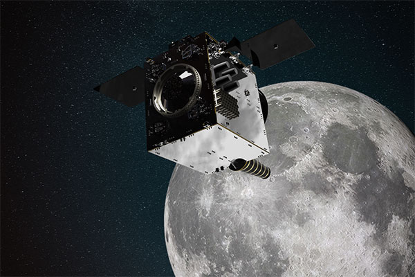
Artist’s impression of the Lunar Pathfinder satellite built by Surrey Satellite Technology Ltd. (SSTL) that will provide communications and navigation services for the Moon.
NASA and its international partners are planning a return to our natural satellite. The following three papers — presented at the Institute of Navigation (ION) GNSS+ conference Sept. 20–24, 2021 — discuss the role of GNSS in lunar exploration. The full papers are available at www.ion.org/publications/browse.cfm.
Using GPS for Time Transfer
NASA and the European Space Agency have conceptualized the initial framework for a GPS-like constellation for the Moon, which will ensure uninterrupted navigation and communication services for future lunar missions. The authors designed a smallsat-based Lunar Navigation Satellite System (LNSS) with time-transfer from Earth-GPS to alleviate the size, weight and power (SWaP) and timing stability requirements of the onboard clocks. A timing filter corrects the lower grade clock when Earth-GPS signals are available and propagates these clock estimates forward in time when no Earth-GPS signals are available. The authors analyzed their proposed time-transfer technique using high-fidelity simulations of an LNSS satellite with an onboard chip-scale atomic clock for three cases of elliptical lunar frozen orbits.
Bhamidipati, Sriramya, Mina, Tara, Gao, Grace, “Design Considerations of a Lunar Navigation Satellite System with Time-Transfer from Earth-GPS,” https://doi.org/10.33012/2021.18021
GNSS Nav for Moon Missions
The authors show the potential of autonomous GNSS signal-based navigation for a set of Moon scenarios. This technology could be a game changer for the future of lunar exploration, representing an extremely low cost and effective alternative for Moon navigation. Results show that not only autonomous GNSS navigation for lunar orbiters is possible, but it also delivers good navigation performance. In fact, navigation with root-mean-square (RMS) errors on the order of 50–100 meters were obtained for scenarios of high interest, such as for the planned Lunar Pathfinder and near-rectilinear halo orbit of the Lunar Gateway space station around the Moon.
Mangialardo, Marco, Jurado, María Manzano, Hagan, David, Giordano, Pietro, Ventura-Traveset, Javier, “The full Potential of an Autonomous GNSS Signalbased Navigation System for Moon Missions,” https://doi.org/10.33012/2021.18040
Finding the best lunar orbit
A continuous and reliable lunar positioning and timing system, such as a GNSS-like constellation, is considered essential infrastructure for lunar exploration. The authors focus on halo orbits with the aim of defining an optimal halo constellation for supporting and delivering a navigation service on the Moon. This paper shows the performance of a GNSS-like constellation deployed in Halo orbits around Earth-Moon L1 and L2 collinear libration points. Different phases have been considered, from a minimum number of satellites able to provide a local PNT service on the South Pole (Initial Operational Capability), to a final, extended constellation able to cover the whole lunar surface (Final Operational Capability).
Musacchio, Daniele, Iess, Luciano, Carosi, Mattia, Capolicchio, Jacopo, Eleuteri, Massimo, Stallo, Cosimo, Di Lauro, Carmine, “Design of Earth Moon Halo Orbits for a Global Lunar PNT Service,” https://doi.org/10.33012/2021.18020
Artist’s impression of SSTL’s Lunar Pathfinder satellite that will provide communications services around the Moon. (Image: SSTL)
News from the European Space Agency (ESA)
ESA is going to the Moon — in collaboration with its international partners — and seeks to build a lasting lunar link to enable sustainable space exploration.
The agency has now evaluated initial ideas to create a network of lunar telecommunications and navigation satellites.
Creating a commercial telecommunications and navigation service for the Moon will allow many of the dozens of planned lunar missions to share the same infrastructure to communicate with Earth, as well as to find their way on the lunar surface.
The service is needed because the planned missions are becoming regular trips to Earth’s natural satellite rather than one-off expeditions.
Using a shared telecommunications and navigation service will reduce the design complexity and weight of individual missions, making them more cost-efficient.
Lowering the ticket price to lunar exploration could also empower a wider group of ESA member states to launch their own national lunar missions, inspiring the next generation of scientists and engineers.
Call for Ideas
The call for ideas for how to use a lasting link with the Moon is open until April 30. People working for commercial companies, universities or governmental organizations are welcome to suggest how they would like to use a lunar communications and navigation service.
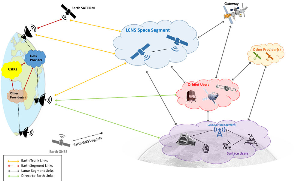
This diagram presents a notional preliminary top-level system concept for a lunar communications and navigation service. (Image: ESA)
Concept Reviews Completed
Two consortia of companies have now completed their system concept reviews, which set out how to create the lunar constellation, under ESA’s Moonlight initiative to identify the best way to create a lasting link with the Moon. The reviews set out the business and technical analysis needed to identify and justify a number of feasible system concepts for creating the lunar network.
The next step will be to define a detailed system architecture and identify the most suitable partnership models between private space companies and ESA.
Telespazio leads the first consortium. The consortium includes:
satellite operators Inmarsat and Hispasat
manufacturing companies such as Thales Alenia Space Italy, OHB System in Germany and Canadian space technology company MDA
Italian Aerospace Logistics Technology Engineering Company (ALTEC)
small and medium-sized enterprises such as Nanoracks Europe and Argotec
universities and research centers such as SEE Lab, SDA Bocconi and Politecnico di Milano.
The second consortium is spearheaded by Surrey Satellite Technology Limited, both in the service prime capacity through its lunar services brand SSTL Lunar and as the satellite manufacturer. The consortium includes:
satellite manufacturer Airbus
satellite network providers SES, based in Luxembourg, and Kongsberg Satellite Services, based in Norway
the Goonhilly Earth Station in the UK
British satellite navigation company GMV-NSL.
Artemis Program and Pathfinder
NASA’s Artemis program will use several of ESA’s service modules to return humans to the Moon, including the ESPRIT communications module for the lunar Gateway’s living quarters for astronauts. With its European industrial partner, ESA is helping to build the Lunar Pathfinder, showcasing lunar communications service provision by providing initial services to early lunar missions, including a complete lunar navigation in-orbit demonstration.
The Moonlight initiative builds on both the ESPRIT communications module and the Lunar Pathfinder.
Russia warned it could blow up 32 GPS satellites with its new anti-satellite technology, ASAT, which it tested Nov. 15 on a retired Soviet Tselina-D satellite, according to numerous news reports.
Russia then claimed on state television that its new ASAT missiles could obliterate NATO satellites and “blind all their missiles, planes and ships, not to mention the ground forces,” said Russian Channel One TV host Dmitry Kiselyov, rendering the West’s GPS-guided missiles useless. “It means that if NATO crosses our red line, it risks losing all 32 of its GPS satellites at once.”
The International Space Station (ISS) Flight Control team was notified of indications of a satellite breakup, causing 1,500 pieces of debris to threaten the station. “Due to the debris generated by the destructive Russian Anti-Satellite (ASAT) test, ISS astronauts and cosmonauts undertook emergency procedures for safety,” said NASA Administrator Bill Nelson.
“With its long and storied history in human spaceflight, it is unthinkable that Russia would endanger not only the American and international partner astronauts on the ISS, but also their own cosmonauts,” Nelson said. “Their actions are reckless and dangerous, threatening as well the Chinese space station and the taikonauts on board. All nations have a responsibility to prevent the purposeful creation of space debris from ASATs and to foster a safe, sustainable space environment.
“Russia has demonstrated a deliberate disregard for the security, safety, stability and long-term sustainability of the space domain for all nations,” Gen. James Dickinson, commander of U.S. Space Command, said. “Russia’s tests of direct-ascent anti-satellite weapons clearly demonstrate that Russia continues to pursue counterspace weapon systems that undermine strategic stability and pose a threat to all nations.”
Photo: Stanislav Ostranitsa/iStock/Getty Images Plus/Getty Images
The European Space Agency (ESA) and National Aeronautics and Space Administration (NASA) have publicly released a globally harmonized assessment of aboveground biomass — information vital for managing global climate change.
The Multi-mission Algorithm and Analysis Platform (MAAP) provides seamless access to aboveground biomass information from both NASA and ESA Earth observation data. The open-science tool is now fully operational and accessible online.
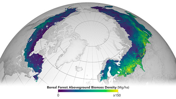
Circumboreal forest biomass density mapped at high spatial resolution (30 m) with NASA’s ICESat-2, the joint NASA/USGS Landsat-8 and ESA Copernicus Digital Elevation Model (DEM) data. This provisional product is representative of 2020 conditions and is an open-source science product created on the NASA-ESA MAAP platform that will be validated in the coming months. (Image: NASA/ESA)
MAAP is the culmination of a two-year NASA and ESA effort and reflects the cooperation between the two agencies under the NASA and ESA Joint Program and Planning Group (JPPG) Joint Working Group (WG) on Ground Segment and Operations.
The MAAP platform enables international scientists and researchers to collaboratively develop algorithms and code as well as analyze and visualize large datasets acquired from sources including satellite instruments, the International Space Station, and airborne and ground campaigns. The large data and high-performance computing required for MAAP, along with a shared code repository and catalog, are stored and managed in the cloud. MAAP capabilities are supported and shared between NASA and ESA.
“Biomass is the first ESA mission with open-source algorithms,” said Clement Albinet, ESA’s Biomass data quality manager. “Thanks to that, the community will be able to access all the source code, the test data and all the documentation, and will be able to contribute in a collaborative way to the improvement of the biomass products. MAAP will allow scientists to easily work with large datasets at a global scale and to finally focus on science.”
The initial application of MAAP focuses on aboveground biomass to help determine the size and carbon content of Earth’s forests. These data are vital for informing our understanding and forecasting of climate change, including regular updates to the Intergovernmental Panel on Climate Change (IPCC).
While biomass is the first application of MAAP, it can be adapted for collaborative exploration across the breadth of science data and scientific disciplines available through NASA, ESA and similar research agencies.
MAAP includes data from missions such as NASA’s Global Ecosystem Dynamics Investigation (GEDI) and the joint NASA/ESA AfriSAR campaign, and will eventually support data from upcoming NASA and ESA missions such as the joint NASA/Indian Space Research Organization SAR (NISAR) and ESA’s Biomass mission.
Several projects are producing continental to global biomass maps for 2020, including ESA’s Climate Change Initiative Biomass and JPSs global map, both at 100 m, as well as NASA’s GEDI 1-km map. GEDI, the Global Ecosystem Dynamics Investigation, is a spaceborne laser instrument that measures the structure of Earth’s forests in high resolution and three dimensions.
The world’s Earth observation biomass community is undertaking an exercise on MAAP aimed at resolving discrepancies between those products and producing harmonized estimates of biomass and uncertainty at a policy-relevant, jurisdictional-level scale.