The UPP results will provide a proof of concept for UTM capabilities and serve as the basis for policy considerations, standards development and the implementation of a UTM system.
“The demonstrations will help move us closer to safe beyond-visual-line-of-sight drone operations,” said Pamela Whitley, the FAA’s acting assistant administrator for NextGen. “Flight testing UTM capabilities in high-density airspace will help us develop policy for safely and efficiently integrating drones into our national airspace while benefiting and serving communities.”
The demonstrations showcased emerging UTM capabilities that will support beyond-visual-line-of-sight (BVLOS) operations:
The FAA UTM Flight Information Management System prototype and infrastructure, which gives the FAA access to information from industry and other stakeholders.
New technologies and data to validate the latest international standards for remote identification and support authorized users with specific operator data.
In-flight separation from other drones or manned aircraft in high-density airspace to validate recently proposed international UTM standards to help drones avoid each other.
UAS volume reservations to notify drone operators of emergencies and make sure other UTM capabilities work properly in these scenarios.
Secure information exchanges between the FAA, industry and authorized users to ensure data integrity.
Each event attracted more than 100 participants and included local and state elected officials and representatives from international civil aviation authorities. Both test sites collaborated with drone operators and local public safety agencies to demonstrate scenarios that featured various complex UTM capabilities working together to support BVLOS operations with increasing volumes and densities.
MAAP hosted an event on Oct. 28 in partnership with UAS Service Suppliers (USS) AirMap, AiRXOS, ANRA Technologies, and Wing. On Nov. 9, NYUASTS hosted its showcase in coordination with the Griffiss International Airport, Northeast UAS Airspace Integration Research Alliance (NUAIR), and USS partners AiRXOS, ANRA Technologies, AX Enterprize, and OneSky.
The FAA has worked closely with NASA, industry and other stakeholders since 2017 to identify the initial set of capabilities needed to support small drone operations and advance UTM. The FAA Reauthorization Act of 2018 extended the objectives of the program to further enable safe BVLOS drone operations, paving the way for the program.
Stay tuned for more updates on how emerging technologies are being field tested to support the growing UAS industry.
The U.S. Space-Based Positioning, Navigation and Timing (PNT) Policy tasked the NASA Administrator to develop and provide requirements for the use of GPS and its augmentations to support civil space systems. NASA is exploring the viability and enhancement of GPS and GNSS signals in the Space Service Volume and beyond to support operational U.S. missions and civil space systems. Spirent GNSS solutions and expertise will support testing of the GNSS receivers intended to be deployed in the upcoming lunar exploration, the company said.
“For over two decades, NASA and other space users have selected us to provide leading-edge test and development solutions for missions ranging from short suborbital flights to weeks-long orbits beyond geosynchronous altitudes,” said Ellen Hall, president at Spirent Federal Systems. “Working collaboratively with our customers enables us to meet their demanding test and development needs with the trusted solutions for which Spirent is known.”
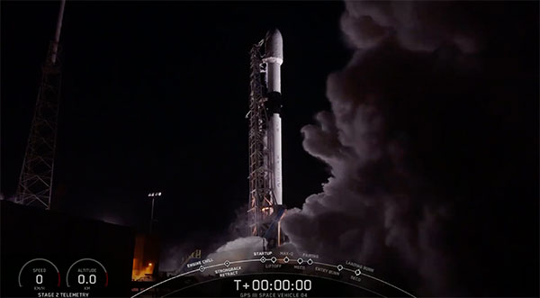
UPDATE: The U.S. Space Force, Space and Missile Systems Center (SMC) and its mission partners successfully launched the fourth GPS III satellite at 6:24 p.m. EST Nov. 5 from Space Launch Complex 40 at Cape Canaveral Air Force Station, Florida.
The Lockheed Martin-built satellite was carried to orbit aboard a Space Exploration Technologies Corporation (SpaceX) Falcon 9 launch vehicle.
“The launch of GPS III SV04 is a testament to SMC’s ability to rapidly and safely deliver new capabilities on orbit,” said Cordell DeLaPena, Air Force program executive officer for SMC’s Space Production Corps. “At SMC, we are proud to deliver our fourth GPS III satellite and will continue to operate at an accelerated pace to enhance the capabilities of the billions of users worldwide.”
“I’m proud of my team’s 83rd successful National Security Space Launch and look forward to our future missions with SpaceX,” said Col. Robert Bongiovi, SMC’s Launch Enterprise director. “Ultimately, our ability to embrace innovation with our launch providers advances warfighter’s capabilities while lowering costs to the U.S. Government and its taxpayers.”
GPS III SV04 separated from its upper stage approximately 90 minutes after launch. Engineers and operators at Lockheed Martin’s Waterton Facility will now begin on-orbit checkout and tests, which are estimated to complete in approximately one month. Operational use is expected to begin in a few months.
“The GPS III program continues to make strides in modernizing the GPS constellation for the U. S. Space Force while maintaining the gold standard for position, navigation and timing,” said Col. Edward Byrne, Medium Earth Orbit Space Systems Division chief.
GPS III SV04 will join the current GPS constellation comprised of 31-operational spacecraft. GPS III, the newest generation of GPS satellites, brings new capabilities to users, including three times greater accuracy and up to eight times improved anti-jamming capabilities.
A Falcon 9 carrying GPS III SV04 lifts off from Cape Canaveral Air Force Station, Florida, Nov 5. (Photo: SpaceX via USAF)
GPS constellation status
According to the U.S. Space Force Second Space Operations Squadron (2 SOPS), the satellite is designated SVN-77/PRN-14 in the GPS almanac. GPS III SV04 (SVN-77/PRN-14) will replace SVN-44/PRN-28 in the B plane at slot 03. 2 SOPS will issue a Launch NANU after on-orbit checkout when control of SVN-77 is transferred from Lockheed Martin to 2 SOPS for insertion into the GPS control segment.
GPS III SV-2 (SVN 75), launched Aug. 22, 2019, replaced SVN 45/PRN-21 at D3 and was set healthy on April 1, 2020. As a result, SVN 45 is being re-phased from D3 to D2F replacing SVN 46/PRN 11 and will arrive sometime in November of this year. SVN 46 will be taken out of the operational constellation before the January 2021 launch of GPS III SV05 (SVN-78) and sent to Launch, Anomaly, Resolution, and Disposal Operations (LADO), making PRN-11 available.
GPS III SV-03 (SVN 76, PRN-23) launched June 30, 2020, and was set operational and healthy on October 1.
SVN-46, launched October 7, 1999, has been an “iron bird” workhorse in the D-plane and has successfully served the world’s GPS users for more than 20 years, 12 years past its designed service life. It outlasted (and in many cases, outperformed) many of its peers on-orbit, testament to quality engineering and the diligent efforts of the men and women of the U.S. Air Force.
Screenshot: SpaceX
The fourth GPS III satellite (GPS III SV04) is scheduled to launch today at 06:24 p.m. EST (~15 minute launch window) from Cape Canaveral Air Force Station, Florida, on a SpaceX Falcon 9 rocket. The new launch window follows an aborted launch with two seconds to go on Oct. 2.
Built by Lockheed Martin, GPS III satellites are designed to help the U.S. Space Force modernize the current GPS constellation with new technology and advanced capabilities. GPS III provides three times greater accuracy and up to eight times improved anti-jamming power over satellites in the current constellation. GPS III also adds a new L1C civil signal compatible with Europe’s Galileo global navigation satellite system, which will provide greater civil user connectivity in the future.
After adding GPS III SV04, the four GPS III satellites on orbit will represent about 12 percent of the 31 satellites in the GPS constellation.
GPS III SV04 is the 23rd M-code-enabled satellite in the constellation, only one short now of the 24 needed for global coverage. M-code is a more-secure, harder-to-jam or spoof signal invaluable to U.S. and allied military forces.
GPS III SV03, which lifted off from the Cape on June 30, was set operational on Oct. 1. The next satellite — GPS III SV05 — was declared “Available for Launch” in May 2020. The satellite is now waiting to be called up for a launch date in 2021. Five more GPS III satellites are in production, three of which are fully assembled and in testing.
Lockheed Martin is also under contract to build up to 22 additional GPS III Follow On (GPS IIIF) satellites, which add additional technology and advanced capabilities to this warfighting system, including a new Regional Military Protection Capability, which will increase anti-jam support in theater to ensure U.S. and allied forces cannot be denied access to GPS in hostile environments; an accuracy-enhancing laser retroreflector array; a fully digital navigation payload; and a new search and rescue payload.
In July, the Space Force declared that the GPS IIIF program had fulfilled Milestone C, which means the start of the production phase. Lockheed Martin has introduced augmented reality tools into the GPS IIIF production process to drive even-greater efficiency into the production process.
Continued investment in GPS is important. Besides the military applications, the U.S. economic benefit of GPS is estimated to be over $300 billion per year and $1.4 trillion since inception.
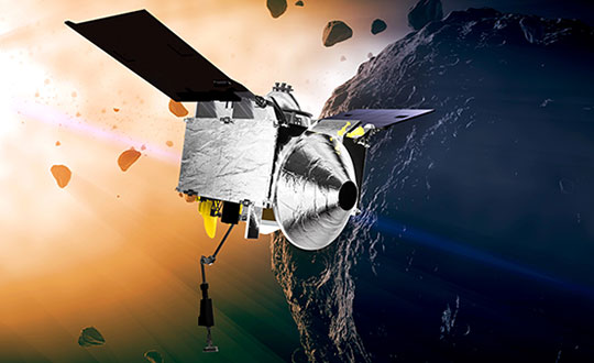
NASA took on a Herculean precision positioning task that culminated Oct. 20 with a spacecraft sampling the surface of an asteroid from a 5-meter area — a NASA first.
The OSIRIS-REx spacecraft, launched on Sept. 8, 2016, spent two years mapping the Bennu asteroid to determine the best site for removing the sample. Bennu was selected because of its near-Earth position (a mere 200 million miles away) as well as its age. It’s considered a primitive remnant from the formation of the solar system. It’s the smallest body a spacecraft has ever orbited.
The infrared spectrometer on OSIRIS-REx confirmed Bennu was sandy, but photos showed it to be an unrelenting rockscape dominated by boulders. Because of this difficult terrain, the planned sample site was reduced from 50 meters to 5 meters, an area smaller than a parking lot. “This required us to rethink how to navigate to the surface and come up with new ideas,” said Coralie Adam, TAG navigation manager for KinetX Aerospace. TAG stands for Touch-And-Go, the sample-collecting procedure.
The mapping method changed from using a lidar-based technique to an optical-based technique. “When we saw what Bennu looked like, we realized we had to switch to a vision-based approach, and that’s the NFT system,” explained Mike Moreau, Osiris Rex deputy project manager, Goddard Space Flight Center.
The Natural Feature Tracking (NFT) was added to the mission at the critical design review stage. NFT is an onboard optical navigation system that compares observed images to a set of asteroid terrain models rendered in real-time from a catalog stored in the flight computer’s memory. Onboard knowledge of the spacecraft state is then updated by a Kalman filter using the measured residuals between the rendered reference images and the actual observed images. (Read a technical paper on NFT.)
The asteroid terrain models used by NFT are built from a shape model generated from observations collected during earlier phases of the mission and include both terrain shape and albedo information about the asteroid surface.
“The KinetX navigation team spent last two years to learning how to navigate around Bennu using optical navigation techniques,” Adam said. She explained that every few minutes, a navigation camera takes an image of the features below and sends it to the NFT. The system identifies features in the image and sends a signal back to Earth.” The KinetX team worked with the Lockheed Martin team to map the surface of Bennu to a resolution of 2 centimeters per pixel.
With this observational data, the team created a hazard map. With position uncertainty down to half a meter, a sample site dubbed Nightingale was successfully contacted, and 2 ounces of regolith collected.
The team included mission managers from the University of Arizona, Lockheed Martin, and NASA’s Goddard Space Flight Center.
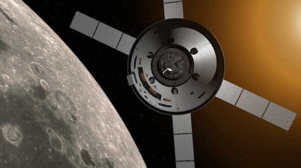
The Origins, Spectral Interpretation, Resource Identification, Security-Regolith Explorer (Osiris-REx) spacecraft
is scheduled to depart Bennu in 2021, and to deliver the collected sample to Earth on Sep. 24, 2023. It will be the first U.S. mission to carry samples from an asteroid back to Earth, and the largest sample returned since the Apollo missions.
Artist’s concept of the OSIRIS-REx spacecraft orbiting the Bennu asteroid. (Image: NASA)
The aborted launch of the fourth GPS III satellite has sparked an investigation into the SpaceX Falcon 9’s Merlin engine. With only two seconds before launch, SpaceX stopped the scheduled launch of the fourth GPS III satellite on Oct. 2.
Tim Dunn of NASA’s Launch Services Program said at an Oct. 16 briefing that the engines had undergone significant testing since the GPS III launch scrub, including taking the Merlin engines from that rocket back to SpaceX’s McGregor, Texas, test site for further study, reports SpaceNews.com. That investigation has involved NASA and Space Force personnel working with SpaceX.
While the GPS III launch has not been rescheduled, Dunn said that the NASA and SpaceX personnel have learned much, with implications involving the rocket hardware.
GPS III SV04 rests atop a Falcon 9 rocket, waiting to be sent into orbit. (Photo: SpaceX)
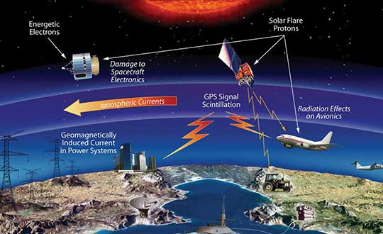
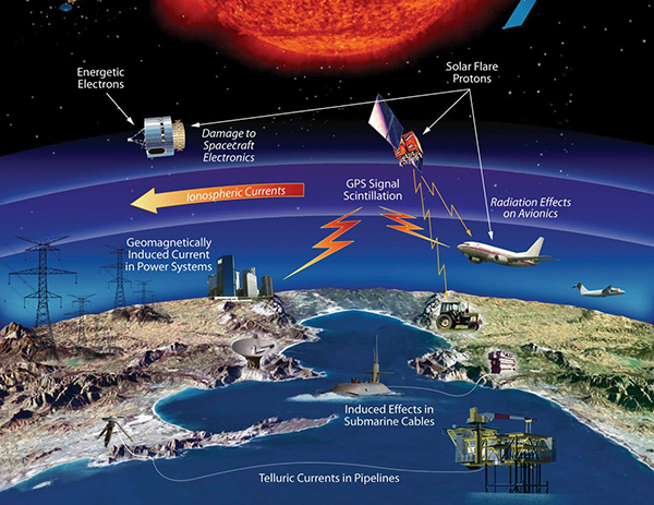
The effects of space weather on critical Earth systems. (Image: NASA)
The United States Congress has passed bipartisan legislation to address how the government deals with threats posed by emissions from the Sun to critical infrastructure such as GPS.
The Promoting Research and Observations of Space Weather to Improve the Forecasting of Tomorrow (PROSWIFT) Act S.881 now awaits signature by the president.
The bill sets forth provisions to improve the ability of the United States to forecast space weather events and mitigate its effects.
It provides statutory authority for the National Science and Technology Council’s Space Weather Operations, Research, and Mitigation Working Group, which coordinates executive branch efforts to understand, prepare, coordinate, and plan for space weather.
The bill directs the Office of Science and Technology Policy, National Oceanic and Atmospheric Administration (NOAA), National Science Foundation, Air Force, Navy, National Aeronautics and Space Administration (NASA), National Security Council, and Federal Aviation Administration (FAA) to carry out specified space weather activities.
The legislation
assigns roles and responsibilities to agencies involved in space weather research and forecasting
ensures agency coordination to better predict severe space weather events and mitigate impacts
calls for coordination between the government and the non-governmental space weather community including academia, the commercial sector and international partners.
Senators Gary Peters (D-MI) and Cory Gardner (R-CO) introduced the first version of the bill in 2016 and a successor passed the Senate in 2017. Reps. Ed Perlmutter (D-CO) and Mo Brooks (R-AL) shepherded it through the House, which passed it Sept. 16.
A recently unclassified CIA drone program provides us with perspective on UAS development. Also, U.S. high-altitude surveillance capabilities are being tested, another record has been achieved, and an award for the U.S. Air Force space plane.
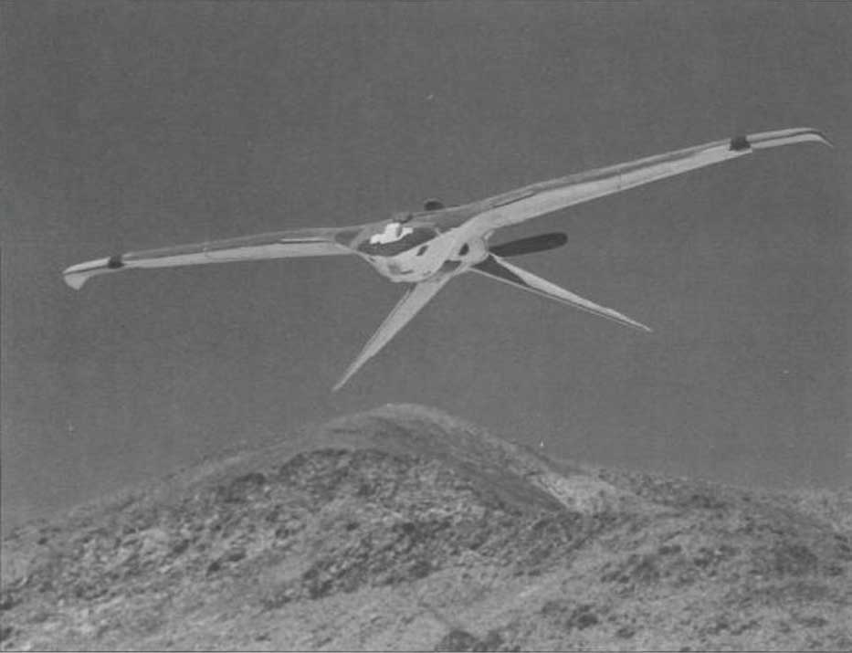
1960s CIA Bird-Drone
Back when the U.S. was flying U2 spy planes over the Soviet Union and Gary Powers was on Russian TV after being shot down, the CIA got to thinking of another approach for gathering airborne intelligence.
Project Aquiline was an early drone project aimed at making overflight much less conspicuous — because the drone was built to resemble a bird.
Project Aquiline was contracted to McDonnell Douglas, which produced five prototypes. (Photo: CIA Archives)The Project Aquiline bird drone in flight. (Photo: CIA Archives)
With a two-stroke engine driving a pusher-propeller and an 8-foot wingspan, five prototypes were built and tested through 1967-68. The concept was to fly at lower altitudes than the U2, carrying equivalent camera and electronic surveillance equipment, but to be very difficult to observe from the ground.
Although a two-stroke engine might have been somewhat noisier than a large bird, later phases of the program envisaged a miniature nuclear power source which presumably would have been much quieter with a relatively huge range.
The project began in 1966, and prototypes began operational testing in 1968. The prototypes established a range of around 130 miles, took high-resolution images and successfully returned to the control site.
However, with many stages of development still to go (the cost to complete was maybe too high), the project was canned in November 1971.
Maybe this initial “bird” concept is where the name of today’s high-altitude, long-endurance Global Hawk drone originated — who knows?
NASA High-Altitude Long-Endurance (HALE) UAVs
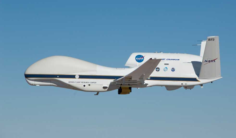
But the U.S. government seems to have other objectives than just high-altitude reconnaissance. NASA has operated the Global Hawk drone for science missions for a number of years, alongside the U-2 and ER-2 high-altitude manned aircraft.
Armstrong Flight Research Center operates two Global Hawks with support from Northrop Grumman out of Edwards Air Force Base.
Global Hawk is flown with a pre-loaded mission profile at upwards of 60,000 feet, sometimes for as long as 24 hours and more than 8,000 miles. Nevertheless, the aircraft is monitored over both satellite and terrestrial links, with direct sensor payload access throughout.
The Global Hawk. (Photo: NASA)
Global Hawk is powered by a Rolls-Royce AE3007H turbofan engine. It has a wingspan exceeding 116 feet, measures 44 feet from nose to tail, has a gross takeoff weight of 25,250 pounds and carries a 1,500-pound payload.
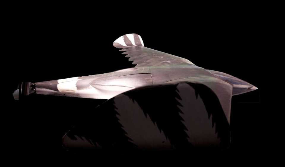
But this aircraft is massive compared to another recent high-flying project that NASA funded through a Phase I and II Small Business Innovation Research/Technology Transfer (SBIR/SBTT) program.
The Swift HALE unmanned aircraft system (Photo: Swift Engineering/NASA)
With the help of NASA’s Ames Research Center, Swift Engineering in San Clemente, California, completed a two-hour flight test on July 7 of its High-Altitude Long-Endurance (HALE) UAS, aiming to join the group of companies already in the high-altitude UAV club.
The 72-foot wingspan, solar-powered HALE weighs <180 pounds, carries a 10-15-pound payload and is destined to fly at up to 70,000 feet for more than 30 days.
This HALE aircraft is expected to complement existing NASA observation platforms and provide unique material alongside existing satellite data. Swift Engineering has been working with NASA Ames since 2016 on a proof-of-concept solar-powered UAS aimed at sustained flight for a month or more.
Swift researched solar panels and high-power, multiple-cycle rechargeable battery technologies to develop a system that could survive harsh temperatures as well as the radiation encountered at high altitude.
During the first of a series of flight tests at Spaceport America in New Mexico on July 7, operations at low altitude were completed to verify systems, aerodynamic control and power-system models. The July 7 flight was the first in a series to collect data and further validate the design.
With NASA, Swift has developed a UAS to not only meet observation objectives, but also one that aligns with the Federal Aviation Administration’s view of HALE deployment and maintenance during extended flights. For the test flight, the vehicle carried a NASA FluidCam for science missions, with a focus on mapping coastal reef systems.
NASA teams are exploring how aircraft such as Swift’s could perform as pseudo-satellites for air-quality monitoring, image coastal zones, map landslides and geologically active regions, and for real-time forestry and agricultural monitoring.
The next step in the development is expected to be a Phase III series of scientific observations at high altitude for days and even weeks.
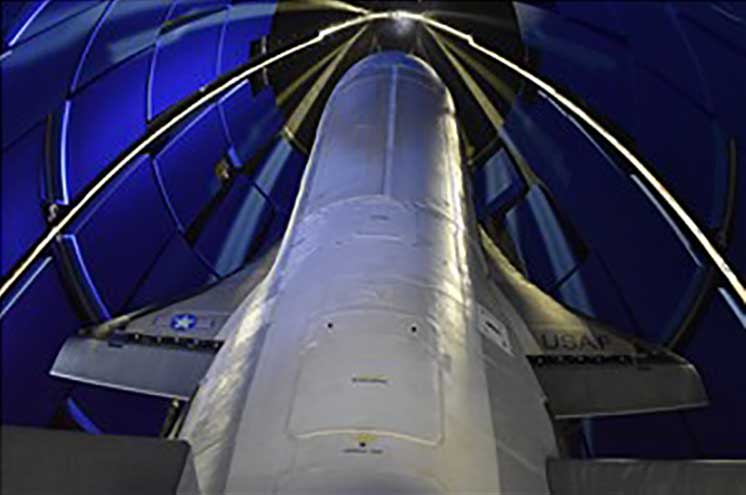
Boeing X-37B Team Wins Collier Trophy
The Air Force/Boeing X-37B autonomous space plane has won the Collier Trophy for best in U.S. aeronautics/astronautics performance and safety in 2019.
The X-37B set a new 780-day on-orbit record and descended through the controlled U..S National Airspace System (NAS) to land at NASA’s Kennedy Space Center.
Initially launched in 2010, the reliable, reusable and unmanned X-37B has provided space access and subsequent analysis for a large number of key experiments.
The Air Force/Boeing X-37B autonomous space plane has won the Collier Trophy. (Photo: USAF/Boeing)
The space plane has now broken its previous on-orbit record of 718 days and has orbited for 2,865 days and more than 1 billion miles in total. Originally designed for only 270 days in space, the X-37B has established endurance records in every one of its last five flights.
Since 1911, recipients of the Collier Trophy have included Orville Wright, the Apollo 11 lunar landing team, the International Space Station team, the U.S. Navy F/A-18E/F Super Hornet team and the Boeing 787, 777 and 747 passenger aircraft teams.
Intelligence Gathering
News about the 1960 CIA drone developments, aimed at gathering unobserved photo reconnaissance intelligence, provide new perspective on NASA’s current-day use of high-altitude observation assets. These are the same types of assets that the U.S. currently uses for intelligence gathering, despite being recently intercepted by Russian jets off the coast of Alaska. It makes for interesting aspects of drone history, along with new aspects of (very) high-altitude unmanned capabilities.
Not surprisingly, the primary topic at the July 1 meeting of the National Space-based Positioning, Navigation and Timing Advisory Board was the Federal Communications Commission (FCC) decision on Ligado Networks.
In it Captain Sullenberger cited many of the issues the board’s vice chair, Brad Parkinson, discussed later in the meeting. Sullenberger’s statement is available here.
In his presentation, Parkinson called the FCC decision “a grave error.” He outlined his rationale in 21 information-packed slides.
Parkinson summarized his presentation up front with three points:
Repurposing the Mobile Satellite Services (MSS) radio spectrum is very high risk and brings virtually no near-term benefit to the United States.
The risks affect much more than the Department of Defense: high-value civil applications are also in jeopardy.
Any such repurposing should have been subject to a formal rulemaking process.
At the end of the presentation, the board voted unanimously to adopt the presentation, with slight modifications, as a reference document for posting on the board’s website.
The group had previously made strong recommendations to the Departments of Defense and Transportation to oppose any such action by the FCC. Both departments have done that and are continuing to do.
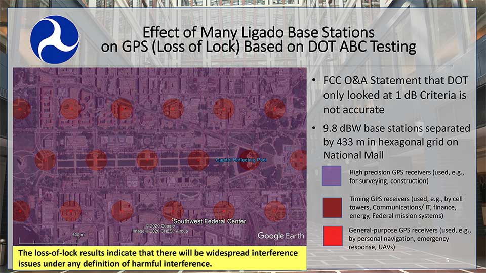
Hazardous information versus losing lock
One slide in Parkinson’s presentation included a Department of Transportation (DoT) depiction how of Ligado transmissions would cause several types of receivers to “lose lock.” This graphic was used in a recent DoT presentation to the FCC.
DOT briefing to FCC: “Concerns Over Ligado Order & Authorization,” June 2020. (Slide: DOT)
Heretofore DoT has usually discussed the points at which Ligado transmissions would cause a 25% increase in the noise floor for receivers. This is an important metric as tests have shown that beyond that point many receiver types begin to give hazardously misleading information. DoT officials have used the example that the 1dB limit is like putting a load limit on vehicles crossing a bridge so that the bridge never reaches its breaking point. An important consideration with a safety-of-life application like GPS.
The National Space-Based PNT Advisory Board. (Board photo)
A receiver often gives inaccurate positioning and timing data, possibly hazardously misleading information, before it “loses lock” and stops providing any information at all. It is more difficult for a receiver to “acquire lock” than to track satellites and provide information, so equipment is rarely able to function again until it moves out of the area of interference.
When asked why DoT would bother to show such information to the FCC, one official suggested that loss of lock was more in line with the criteria the Commission used in making the Ligado decision. The hope was that, by showing that even this flawed standard had significant impacts which the FCC perhaps did not fully recognize, further technical discussions and reconsiderations could be realized.
Other Topics
While discussion of the FCC’s decision took the most time in the on-line meeting, several other issues were discussed as well.
Colonel Curtis Hernandez from the National Security Council briefly described development of a new space-based PNT policy to replace NSDP-39 which was put in place by President Bush in 2004.
He was not able to provide any specifics as it is a draft and still under consideration. Answering a question, he did say that the draft policy outlined the responsibilities of various departments, including for interference detection and monitoring.
Adam Balkcum from the Office of Science and Technology Policy discussed his office’s nascent efforts to investigate non-GNSS PNT as directed by the recent Executive Order on Responsible Use of PNT. The question of whether this includes possible PNT services from low earth orbit and geostationary satellites remains an open one.
Other presenters included:
Seth Jonas of the National Security Council staff on the recent Executive Order on Responsible Use of PNT,
Andrew Hansen of the Volpe Transportation Systems Center who spoke about efforts to monitor for GPS interference, especially in the post-FCC Ligado decision environment, and
NASA’s Chris Bonniksen discussed issues with operating and funding the agency’s Global Differential GPS system.
The agenda for the meeting and presentations are available here, as will be the meeting minutes once they have been finalized.
Everywhere we look, data is being collected, reviewed, analyzed and stored. It used to be that data was a static piece of information, like a piece of paper in a filing cabinet. Millions of pieces of data being created yet almost all of it never to be used again. The computer and electronic storage began a revolution of how we warehouse this information but that was only the beginning. Technology has turned data into a living, breathing beast few understand yet it controls most of our lives in various ways.
Mapping of the earth has not always been about establishing boundaries and parcels; many of the early maps and plats were created to depict the topography of our world. While there are some indications that Middle East maps depicted parcels, the first examples of topographic maps were created during the Roman Empire era of 300 A.D. It is common knowledge that the Romans utilized primitive yet cunning engineering for roads, buildings, and waterways but it was the initial topography that was mapped that allowed them to design those forward-thinking infrastructure components. Because of the lack of sophistication in the measuring methods and data collection, these topographic maps covered small areas and often crude because of the materials available. Considering what they were working with, it is still incredible what they were able to map, design and build.
Measuring devices and methods of data collection expanded over the centuries like most occupations and professions. By the 16th and 17th century, mathematics has been introduced at a wider scale through many educational facilities. Another profession, geographers, also advanced with the evolution of measuring devices and mapping techniques. It was during this period that we began to see a crossover with surveyors with geographers to create topographic maps with greater accuracy and precision through triangulation.
In the 18th and 19th century, instruments became more sophisticated to assist in the determination of elevations and more accurate angle measurements. The concept of triangulation flourished during this period and significant mapping was made for most of the civilized world. The early 1800s saw the westward push of expansion in the United States and Thomas Jefferson, U.S. president and former surveyor, led the charge to map the existing states and divide the west into sectional land for sale to settlers.
Besides the establishment of the Public Land Survey System, surveyors also provided topographic information for map of all sizes for future development planning. The late 1800s brought a large amount of topographic mapping information to paper through efforts by the U.S. Geological Society to map the entire United States. This information has been called the first land database; although crude in overall nature compared to today’s standards, it contained an enormous amount of topographic information.
These surveys continued well into the early 20th century until a revolutionary invention coupled with a current technology merged: the use of a mounted camera taking aerial photographs from an airplane. Geographers and photogrammetrists were able to use surveying data to assist with scaling orthometric photographs to create aerial images of thousands of acres of land. These aerial photos became the base layer for determining topographic features and contouring, covering much more land than ever before. Additional innovations included advancements in stereo plotting and photogrammetric techniques to further create high sophisticated topographic maps for the era. This type of mapping was the gold standard for decades depicting existing condition and topographic features for most of the world until the early 1970s and the computerized data revolution.
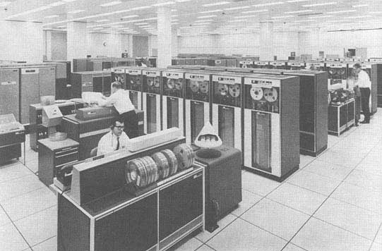
Computers take over the world (literally)
1960s mainframe computer (Photo: NASA)
While mainframe computers became more universally used in the 1960s, their use was contained to governmental agencies and large corporations. As the physical size of the computer reduced, the computing capacity increased, programming became easier to complete, and more applications were created to perform a variety of tasks. One of the biggest advancements for the era was electronic storage and analyzation of data through programming. Relational databases became a hot ticket for large datasets; geographic data was the perfect fit for this type of application. Modern mapping was on its way forward at warp speed.
Topographic mapping was not lost in this shuffle. The survey itself is based upon data points located on the face of the earth so each point is just another chunk of information within the database. Programming continued to advance and soon methods previous completed by manual methods over long periods of time were completed in a fraction of previous efforts without fail.
This effort was also joined with advancements in graphical technology to display this data on a computer video screen instead of lines of green text and numbers. Vector-based graphics, together with enormous point databases, helped create large topographical and geographical maps for many uses. During the same time the US put a man on the moon, mapping and platting of topographic information was also out of this world.
The turn of the century brings big changes
For the next decade, there were small advances in technology for topographic surveys and data points, but most were in presentation of data and increases in computing power. Pen plotters and smaller yet more powerful computers were becoming affordable to smaller companies, but it was still a large investment to get into the computerized data game for a surveyor. By the mid-1980s, electronic data collection with a total station was becoming the norm, but only meant collecting more points in a more efficient timeframe. The computing component did get faster but is still producing the same information of static data points.
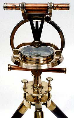
Ancient techniques and new technologies (Image: ngs.noaa.gov)
The mid-1980s also brought us a shiny new object: GPS technology. By the end of the 1990s, we were able to get out of our vehicle, start the receiver and collect geolocated points in minutes rather than hours. The big takeaway from this advancement is the geolocation component of the data point. Now everything can be related to one big dataset of topographical points. By creating a database with all our project data collected in the same georeferenced datums (horizontal & vertical), we can create digital models that replicate existing conditions.
We can also add another big advancement in data collection: remote sensing technology. From laser and lidar scanners, photogrammetry, SLAM technology and ground penetrating radar, the innovations to collect data at locations we can “see” through sensing are now a reality. Another significant improvement with this technology is the amount of data points remote sensing can collect, both in timing and spacing. We are now talking small scanning projects that consist of billions of points within the site point cloud. We are fortunate that our computing power and storage capabilities has increased exponentially along with the remote sensing. (Remember doing a “regen” on your CAD file and having time to get a cup of coffee?)
Lots of data — now what?
Data is powerful, especially when it is harnessed in a robust system that can analyze and model for future use. Yes, this condition also applies to the surveying world, even though you may not be thinking about it now. We can use this data to create a virtual world that mimics the one we live in; the difference is that we exist in ours yet model and manipulate the digital version in our computer system. The technology is now available, and we can make a replica of our current world; however, why would we want to do that? There are lots of reasons to use technology and data to make sophisticated topographic maps (because that is what they are) for recording the world around us.
One of the big differences now is that we have much more information about the data points we collect within our topographic maps. Sure, many surveyors will say that their data has not changed or evolved during their careers, but they would be wrong. Unless they are still manually writing it all down for hand plotting… (Hello! The 1960s called, and they want their field book back!) Every electronically collected point has attributes associated with the data.
These attributes, while they may be simple, contain important information about the datapoint it represents. Horizontal location? Check. Vertical elevation? Check. Assigned point number? Probably. Field code? Most likely. But it also has one other important component: time. We now know exactly when that point was collected. Why is that important?
Because, like a lot of instances, things change. Something collected today might not be there tomorrow. Time is just as important as the physical location and the type of point it represents.
Gather these points together, throw them in one big model and you have yourself a graphical database that can be analyzed, reviewed, and used for planning and design. It may be hard to visualize with just simple survey data using GNSS and/or a total station, but couple it with a scanner or photogrammetry, you have a powerful hunk of data for which to work.
Why is this workflow and modeling procedure important enough to dedicate an entire column about surveying and GNSS to? Because it used to be far in the future, but the need and availability to use it is now here in front of us. Surveying and GNSS are an important part of this effort to create three dimensional models. By using survey-grade data in conjunction with point clouds collected from remote sensing equipment, we can replicate the world around us in real time.
Yes, Virginia, there is a name for the modeling process…
Photo: iStock.com/alexsl
The name for the proposed modeling of this dataset is a digital twin. It represents a digital representation of a physical object or system. NASA famously used the concept for their space program to simulate situations and procedures of many different types of events. The concept has grown with the technology to graphically create almost anything through digitalization and computer modeling. Once the model is created, both actual and proposed data points can be included to represent the existing and future opportunities.
The idea of a digital twin is not new; technology, however, has pumped more life into its existence by leaps and bounds with computing power and data storage capability. I remember, early in my career, going into an architect’s office and seeing the scale model mockup of a new development or building. The streets in the model were perfect, there were no drainage issues, and it was a neat as a pin. Fast forward to the construction of the development and field changes were at every turn. A digital twin will allow for better planning, more thorough design and creating more cost-effective development. Many large cities have started compiling data and building their digital twin, including New York, Singapore, Boston, and Rotterdam. Engineering and planning for new and replacement facilities is very expensive yet analysts predict that having a digital twin to work will save a significant amount of money and time.
As a surveyor, what’s in it for me?
Software capability for the surveyor is already here. Companies, such as Hexagon, Trimble, Topcon and Esri to name a few, have been developing their software to accommodate this concept for many years. Still, lots of surveyors do not know about it. And we should. Many of us live in places where the infrastructure is well past its useful life period and should have been replaced long ago. By starting now with survey-grade data to be put into a real-time model, we can help our governmental agencies and their consultants to move towards a digital twin that will ultimately save money and possibly lives.
What this means for the surveyor is to further embrace technology and include remote sensing into your operation. If you have not started at least looking into UAVs and photogrammetry, you are already behind. Many aerial operations are making the next leap into mounting a LiDAR unit on their UAV to gain even more capability. Early adopters of laser scanners were probably second guessing their decision during the 2008 Depression but if they stayed with it, it will be a big payoff in the long run. The next leap will be into handheld scanning devices, including ones using SLAM (simultaneous localization and mapping) technology for locating interior and close-up improvements. These technologies will cost a significant amount of time and money to implement but municipalities, engineers and architects are going to be clamoring for the data any day now.
When it comes to surveying and mapping of existing facilities, the surveyor and technology makes a great team. Do not let point clouds, remote sensing, or terabytes of data scare you away from providing badly needed information to help assemble your local digital twin. In the long run, it will pay off for all who take on the challenge of building it.
Honeywell, under a contract with Lockheed Martin, will supply guidance and navigation systems for NASA’s upcoming Artemis missions, which will fly humans to the moon for the first time since 1972.
The companies are supplying key components to NASA’s Orion spacecraft fleet for the Artemis missions. Components include the barometric altimeter, the inertial measurement system, and the GPS receiver.
Honeywell will provide 14 product types for Artemis missions III through V, including both hardware and software solutions, to support NASA’s lunar missions. NASA awarded Lockheed Martin a long-term, multibillion-dollar production contract for the Orion spacecraft, aimed to meet the space agency’s anticipated needs into the 2030s.
Working in collaboration with the Orion team over the next decade, Honeywell will support Lockheed Martin and its partners through the development and production of essential guidance and navigation systems, command data handling, and display and control products. The focus of the missions is to conduct science and learn lessons that will help take humans to Mars.
Honeywell will supply the following types of technology for the Artemis missions:
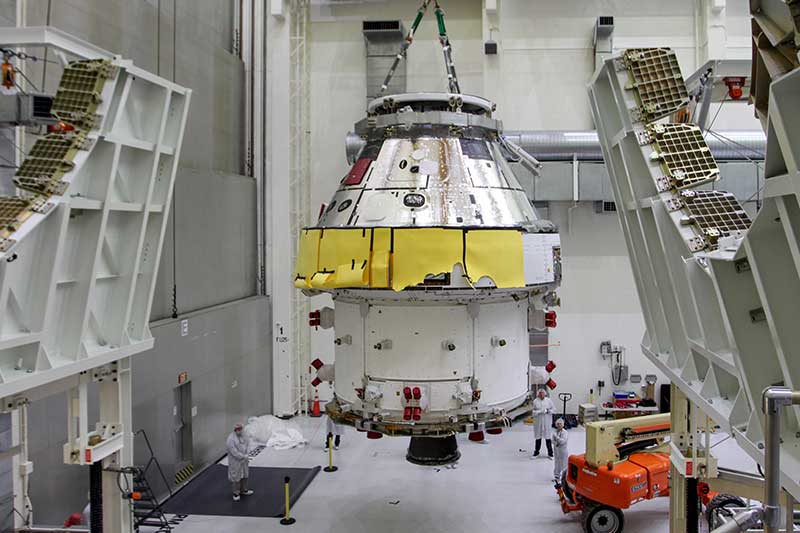
First Orion Spacecraft: In this March 30 photo, Orion I is moved to the Final Assembly and Systems Test cell at Kennedy Space Center. The spacecraft returned from Ohio after a successful series of environmental tests at Glenn Research Center’s Plum Brook Station. (Photo: NASA)
• Guidance and Navigation Systems. Key navigation and guidance solutions, including the barometric altimeter, which tracks the altitude of the Orion capsule in Earth’s atmosphere, as well as the inertial measurement system (INS) and GPS receiver, which track the position and movements of the capsule.
• Command Data Handling. Several data-handling products, including the vehicle management computer, which acts as the central computing platform supporting flight and vehicle control, as well as spacecraft communication functions.
• Displays and Controls. Three display units and struts, seven control panels, and two hand controllers used inside the spacecraft to help astronauts in the Orion capsule monitor and control the vehicle.
• Core Flight Software. Includes the integrated modular avionics software, a key system responsible for supporting maintenance functions sharing flight data information.
The contract to supply key components of the Orion crew module and service module is being managed and performed out of Honeywell’s facility in Clearwater, Florida. Work is also being conducted at the company’s facilities in Glendale, Arizona, and Puerto Rico.
Honeywell was part of NASA’s previous crewed space missions, including those that took humans to the moon.
NASA will be hosting the national space-based PNT advisory board meeting on July 1. The meeting will be held virtually, rather than in-person, 11 a.m. to 3 p.m. Eastern Time.
NASA sponsors the advisory board on behalf of the National Executive Committee for Space-Based PNT. Advisory board members are nominated by the agencies of the National Executive Committee and appointed by the NASA administrator.
According to NASA, this meeting will be formally called the “24th Interim Meeting” in preparation for the 25th meeting in the fall of 2020.
The meeting will cover a number of topics, including:
Updates on emerging U.S. PNT policies;
the status of GPS constellation services and modernization;
techniques to protect, toughen and augment to GPS/GNSS services for multiple user sectors;
alternative or complimentary PNT signals sources to GPS/GNSS signals in a stressed spectrum environment;
opportunities for enhancing the interoperability of GPS with other emerging international GNSS constellations; and
emerging trends and requirements for new PNT services in U.S. and international fora.
Those participating must use a touch-tone phone. Any interested person may dial the USA toll-free conference call number 1-844-467-4685 or toll number 1-720-259-7012, passcode 106724, to participate in this meeting by telephone.
For more information, contact James J. Miller, Designated Federal Officer, Human Exploration and Operations Mission Directorate, NASA Headquarters, Washington, DC 20546, (202) 358-4417, fax (202) 358-4297, or [email protected].
The COSMIC-1 program ended on May 1, when the last of six tiny satellites were decommissioned. The satellites were launched 14 years ago, and outlived their planned lifespan by 12 years.
COSMIC — the Constellation Observing System for Meteorology, Ionosphere and Climate (COSMIC) mission — uses GPS signals to provide a wealth of accurate atmospheric data and improve weather forecasts, according to Laura Snider, University Corporation for Atmospheric Research (UCAR), which ran the COSMIC program.
Meanwhile, the COSMIC-2 program (FORMOSAT-7 in Taiwan) continues. Its six satellites were launched on June 25, 2019, into low-inclination orbits. The mission was launched by NOAA as the agency’s first operational GNSS radio occultation mission.
COSMIC-1 demonstrated the value of GNSS radio occultation (GNSS-RO) to derive vertical atmospheric profiles of temperature, humidity and pressure by measuring the degree to which GPS signals bend as they travel through Earth’s atmosphere.
Weather centers used the high-quality, accurate data to improve forecasts; the data was also used by researchers.
“Throughout its lifetime, COSMIC-1 made an astounding 7 million vertical atmospheric profiles available to the operational forecast centers and research community,” writes Snider. “These data demonstrably boosted forecast accuracy and were referenced in more than 550 peer-reviewed scientific publications. In all, more than 5,000 users from over 100 countries have accessed COSMIC data.
COSMIC-1 was primarily funded by the National Space Organization in Taiwan, where the mission is called FORMOSAT-3. The leading U.S. sponsor on the project was the National Science Foundation. Other U.S. partners included NASA, the National Oceanic and Atmospheric Administration (NOAA), the Air Force and the Office of Naval Research.
UCAR also led the GPS/MET GPS radio occultation mission in the mid-1990s.
 The Federal Aviation Administration (FAA) has concluded the second phase of its Unmanned Aircraft System (UAS) Traffic Management Pilot Program (UTM/UPP).