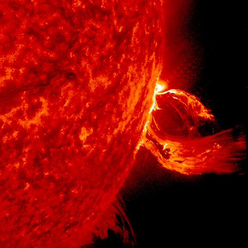
A solar flare in 2015. (Photo: Photo: Solar Dynamics Observatory, NASA)
You wake up and turn on the TV. Your usual shows aren’t airing. You flip on the radio and learn that the Paris and Tokyo stock markets have closed. Back on TV, CNN is trying to use Skype in an attempt to cover what’s happening around the world following a solar superstorm.
In a U.S. bunker, the military has lost contact with armed drones flying over hostile areas in the Middle East. Loss of global communication satellites makes it difficult to send commands and surveillance data to soldiers, ships and aircraft, rendering them vulnerable to attack.
Throughout the day, more challenges arise. First responders don’t have access to their location systems. Delays in ground and air traffic begin to develop. Systems that depend on GPS time stamps — ATMs, power grids, computer-data and cell-phone networks — begin to fail, and the cloud becomes unstable. The internet soon collapses.
These events take place just a few hours into “A Day Without Satellites” as presented by Pål Brekke, solar physicist and senior advisor at the Norwegian Space Agency. Brekke spoke at the plenary session of ION GNSS+ on Sept. 17 in Miami.
Brekke reviewed the Carrington Event of September 1859, the first documented solar superstorm. In that event, a solar coronal mass ejection (CME) hit Earth’s magnetosphere, and its effects were observed and recorded by British astronomers. The storm wrought havoc with telegraph systems.
Today, a solar storm of this magnitude would cause widespread disruptions, blackouts and damage from extended outages of the power grid, communications networks, and of course, GNSS. The solar storm of 2012 was probably as big, but we were lucky — Earth wasn’t in the ejection path.
Without more data, it’s difficult to predict how often such superstorms take place, but it’s a sure bet that the scenario Brekke presented will happen eventually. To prepare, agencies around the world are studying and planning for the phenomenon, including the United Nations Office for Outer Space Affairs (COPUOS), the World Meteorological Organization (WMO) and the International Civil Aviation Organization (ICAO). Space and emergency agencies in the U.S, European countries and other countries are also developing plans.
Good to hear in the face of a threat that would undoubtedly affect us all.
Hyperspectral imagery of U.S. East Coast. (Image: NOAA)
Raytheon will build the Geostationary Littoral Imaging and Monitoring Radiometer (GLIMR) sensor under a contract from the University of New Hampshire. GLIMR, NASA’s selected Earth Venture Instrument-5 investigation, will be NASA’s first hyperspectral imager in geostationary (GEO) orbit.
Hyperspectral imaging collects and processes information from across the electromagnetic spectrum including visible light, infrared and ultraviolet frequencies to create a highly detailed view of physical and biological conditions in coastal waters.
The instrument will provide high-sensitivity, high-spatial and high-temporal resolution measurements of coastal and ocean ecosystems in the Gulf of Mexico, parts of the southeastern U.S. coastline and the Amazon River plume.
Decision-makers will use the GLIMR data to respond rapidly to natural and manmade coastal water disasters, such as harmful algae blooms and oil spills. It will also help improve the coastal ecosystem’s sustainability and resource management.
“GLIMR will collect the sharpest and most colorful view of physical and biological conditions in coastal waters ever seen from GEO,” said Jeff Puschell, GLIMR instrument scientist and principal engineering fellow at Raytheon Space Systems. “A hyperspectral imager is essential technology to capture new insight about our changing coastal ecosystems.”
The University of New Hampshire is NASA’s lead organization for the GLIMR contract. The instrument will launch aboard its host spacecraft in the 2026-2027 timeframe. Its data will be available to scientists, researchers and educators around the world.
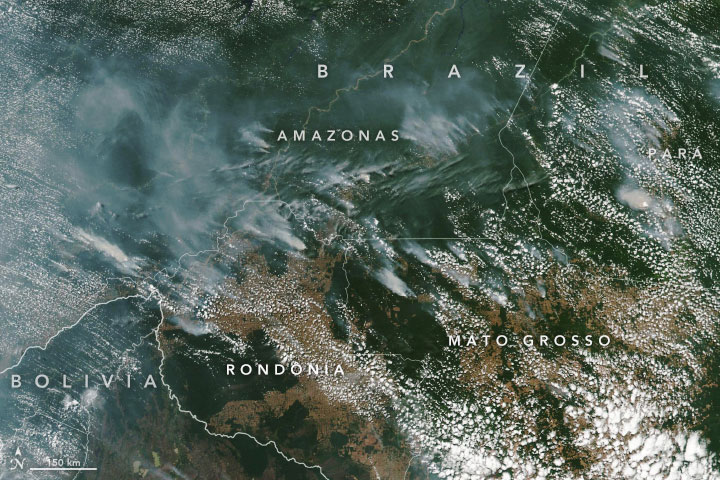
Wildfires in the Amazon rainforest in Brazil have hit record numbers, and satellites have been able to capture imagery of them.
According to NASA, the Moderate Resolution Imaging Spectroradiometer on its Aqua satellite captured images of several fires burning in the states of Rondônia, Amazonas, Pará and Mato Grosso on Aug. 11 and Aug. 13.
A satellite view of the Amazon wildfire on Aug. 13. (NASA Earth Observatory images by Lauren Dauphin, using MODIS data from NASA EOSDIS/LANCE and GIBS/Worldview and VIIRS data from NASA EOSDIS/LANCE and GIBS/Worldview, and the Suomi National Polar-orbiting Partnership.)
There have been 72,843 fires in Brazil this year, with more than half in the Amazon region, Brazil’s space research center, the National Institute for Space Research (INPE), said. This marks an 84% increase over the same period of 2018 and is the highest since records began in 2013, INPE added.
Amazonas, the largest state in Brazil, recently declared a state of emergency over the forest fires, said Euro News.
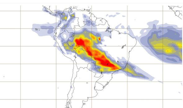
This map shows the “Biomass burning aerosol optical depth.” (Image: Copernicus’ Atmosphere Monitoring Service)
In the Amazon region, fires are rare for much of the year because wet weather prevents them from starting and spreading. However, in July and August, activity typically increases due to the arrival of the dry season, NASA said.
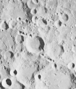
I was inspired by the 50th anniversary of the Moon landing on July 16 and our focus on mapping this month to look into imagery of the Moon.
Only recently have we learned that the lunar orbiters that photographed the Moon in the 1960s sent back images that were stunningly high resolution (HR), even by today’s standards. The actual resolution was presumably kept secret because the imaging technology was also used in our Cold War spy satellites.
Under the Lunar Orbiter Program, satellites took photographs of the Moon’s surface to identify suitable landing sites for the Apollo Program. Managed by the Langley Research Center, five Lunar Orbiters were successfully flown in 1966 and 1967, mapping 99% of the Moon’s surface with a resolution of 60 meters or better.
The first three missions were dedicated to imaging 20 potential landing sites, and were flown at low-inclination orbits.
The fourth and fifth missions were devoted to broader scientific objectives and were flown in high-altitude polar orbits. Lunar Orbiter 4 photographed the entire nearside and 95% of the farside, and Lunar Orbiter 5 completed the farside coverage and acquired medium (20-meter) and high (2-meter) resolution images of 36 pre-selected areas.
In that pre-digital era, the Lunar Orbiters had an ingenious imaging system, which consisted of a dual-lens camera, a film processing unit, a readout scanner and film-handling apparatus. Both lenses, a 610-mm narrow angle HR lens and an 80-mm wide-angle medium resolution (MR) lens, placed their frame exposures on a single roll of 70-mm film.
The axes of the two cameras were coincident so the area imaged in the HR frames were centered within the MR frame areas.
The film was moved during exposure to compensate for spacecraft velocity, which was estimated by an electric-optical sensor. The film was then processed, scanned, and the images transmitted back to Earth. Based on these images, the NASA Apollo Site Selection Board would name five candidate landing sites in February 1968.
“Seen & Heard” is a monthly feature of GPS World magazine, traveling the world to capture interesting and unusual news stories involving the GNSS/PNT industry.
Tethered drone
Spanish police used a tethered drone system for traffic monitoring, crowd control and surveillance of the UEFA Champions League Final, played June 1 at the Wanda Metropolitano stadium in Madrid. An Elistair tethered U06 Plus drone oversaw 67,000 fans in the stadium and 200,000 in nearby streets. Use of the drone was in response to a heightened terrorist threat level in Spain, making it part of the largest security operation for any sporting event in the Spanish capital. Continuously supplied with power, the drone maintained its position at 50 meters high for 8 hours.
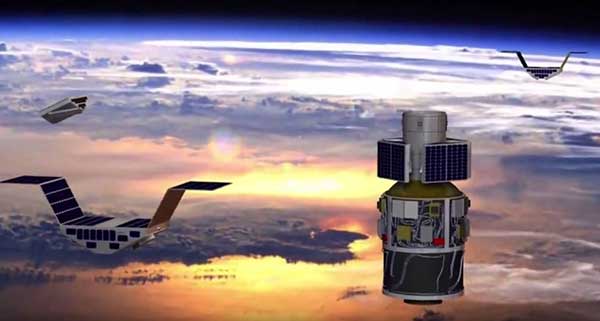
CYGNSS satellite launch. (Artist’s concept/NASA)
Tricky Signals
NASA’s eight CYGNSS (Cyclone Global Navigation Satellite System) microsatellites collect radio signals from GPS beacons to characterize hurricanes. A month after launch in December 2016, the CYGNSS team noticed the signals were wavering when the U.S. began to boost the radio power on 10 GPS satellites as they passed over northern Syria. The swings don’t interfere with other scientific uses of GPS, but for CYGNSS the measurements of high winds varied by 5 meters a second or more — the difference between a category-2 and category-3 hurricane. After two years of work, the CYGNSS team has compensated by repurposing a secondary antenna on the satellites to measure GPS signal strength.
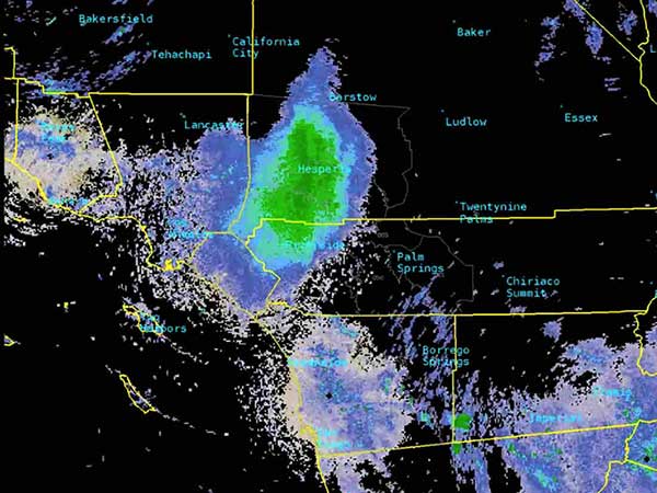
The ladybug blob tracked by Doppler radar. (Image: National Weather Service)
Ladybug, ladybug, fly away home
In this case, California. In June, a millions-strong swarm of ladybugs showed up on radar as a weather event when the insects took to the sky to hunt for aphids. One explanation for the unusual swarm is that a large population of ladybugs had been spread out in a mountainous area, and rising temperatures triggered their mass migration to valleys where they might find an abundance of aphids to eat.
New Zealand joins Aussies on SBAS
Land Information New Zealand (LINZ) will work with Australian counterpart Geoscience Australia to investigate ways to deliver a regional satellite-based augmentation system (SBAS) to significantly improve GPS accuracy. The proposed SBAS will support emergency helicopter crews, providing pilots with accurate vertical guidance for landing, enabling them to reach people faster in difficult terrain and bad weather. The SBAS will also improve the safety of self-driving cars. The new system will improve accuracy to less than a meter, and in some devices to 10 centimeters.
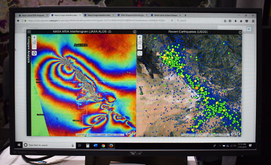
Satellite imagery and mapping have proven to be critical technologies when it comes to disaster relief efforts.
The NASA Earth Science Disasters Program has harnessed these technologies to help communities and governments recover from natural disasters like earthquakes, hurricanes and more.
“[The goal of the program is to] try to prevent natural disasters or limit their impact and also help people recover from them more quickly,” Jeremy Kirkendall, senior GIS administrator for the NASA Disasters Program, told GPS World in an exclusive interview at the 2019 Esri User Conference in San Diego. “We provide the products free to anyone to use, and data is only available if there is a good satellite pass.”
When a natural disaster strikes, researchers at the NASA Disasters Program will take satellite imagery of the affected location and create a map to show what the area looks like from an aerial perspective. Authorities who request this information can then compare the disaster map with maps of what the area looked like before the disaster took place.
“We do take requests from agencies or governments for disasters if they need help if data is available,” Kirkendall said. “We’ll create the products that show where the earthquake damage happened, where the fire burned or where the flooding is, and then users take that — combined with their local information — to determine what needs to be checked.”
For example, the NASA Disasters Program was able to map out the magnitude 6.4 July 4 Southern California earthquake.
“The earthquake that happened on July 4 caused a lot of deformation to the ground, so we mapped out that surface deformation and shared that information with other emergency managers, the Federal Emergency Management Agency, National Guard and U.S. Navy,” Kirkendall said. “You can look at things like roads, utilities, underground pipes for natural gas or geothermal wells, or fiberoptic cables. Then when you provide the product to these end users, they can overlay it with utility and infrastructure information to identify what’s the most at risk and what needs to be investigated.”
Sometimes, when a natural disaster occurs over a longer period of time, data is mapped throughout the duration of the occurrence, as well. This can help with search-and-rescue missions, infrastructure repairs and post-disaster analysis.
“We will create products during responses that can last a long time, like for Hurricane Florence or the flooding that recently happened in the Midwest,” Kirkendall said. “We’ll keep turning out flood products day after day when there’s good satellite passes that show that information.”
Kirkendall added that the National Guard has used the live data, along with 911 calls, to find individuals trapped in flooded houses. The data also serves as a tool for post-disaster analysis to understand where damage occurred, ways to fix it and how to prevent it from happening again.
“The program itself is gearing toward a resiliency effort, where we can provide these products when communities says, ‘We get flooded here all the time, over and over,’” Kirkendall said. “That’s where we need to be prepared to fix something. We need to do something to prevent that.”
GPS could be used to pilot in and around lunar orbit during future Artemis missions.
A team at NASA is developing a special receiver that would be able to pick up location signals provided by the 24 to 32 operational GPS satellites. Such a capability could soon also provide navigational solutions to astronauts and ground controllers operating the Orion spacecraft, the Gateway in orbit around the Moon and lunar surface missions.
The advanced GPS receiver would be paired with precise mapping data to help astronauts track their locations in space between the Earth and the Moon, or on the lunar surface.
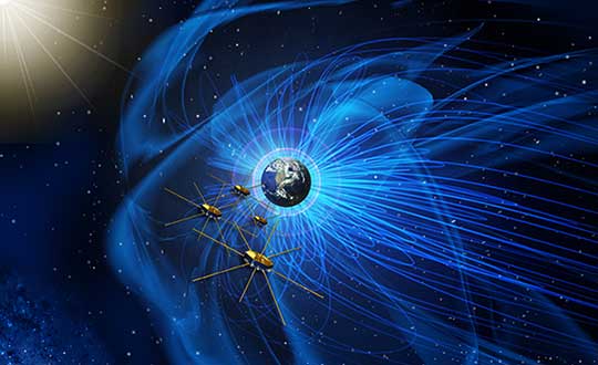
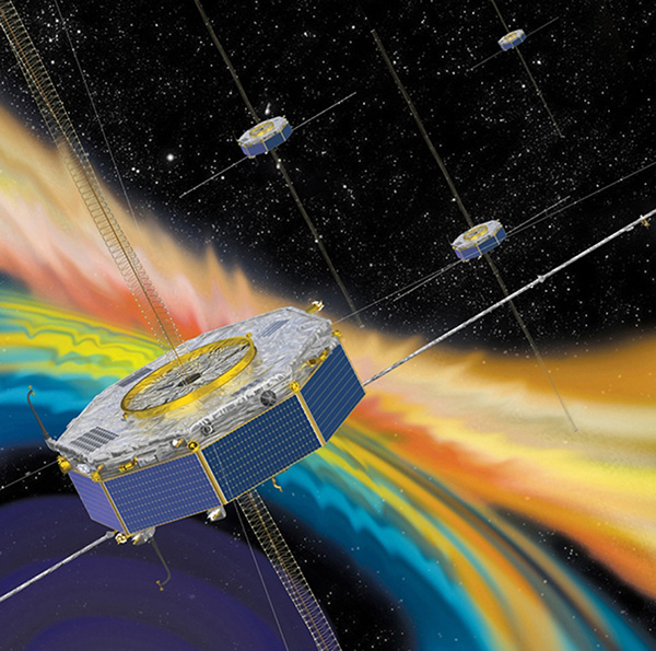
Artist’s concept of NASA’s Magnetospheric Multiscale mission consists of four identically equipped observatories that rely on Navigator GPS to maintain an exacting orbit that is at its highest point nearly halfway to the Moon. (Image: NASA)
Navigation services near the Moon have historically been provided by NASA’s communications networks. The GPS network could help ease the load on NASA’s networks, freeing up that bandwidth for other data transmission.
“What we’re trying to do is use existing infrastructure for navigational purposes, instead of building new infrastructure around the Moon,” said engineer and principal investigator Munther Hassouneh at Goddard Space Flight Center in Greenbelt, Maryland.
NASA has been working to extend GPS-based navigation to high altitudes, above the orbit of the GPS satellites, for more than a decade. The agency now believes its use at the Moon, which is about 250,000 miles from Earth, can be done.
“We’re using infrastructure that was built for surface navigation on Earth for applications beyond Earth,” said Jason Mitchell, chief technologist for Goddard’s Mission Engineering and Systems Analysis Division. “Its use for higher altitude navigation has now been firmly established with the success of missions like Magnetospheric Multiscale mission (MMS) and the Geostationary Operational Environmental Satellites (GOES). In fact, with MMS, we’re already nearly halfway to the Moon.”
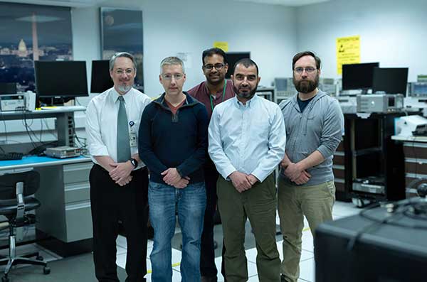
Navigator GPS
The team developing a GPS receiver for use in and around lunar orbit (from left): Jason Mitchell, Luke Winternitz, Luke Thomas, Munther Hassouneh and Sam Price. (Photo: NASA/T. Mickal)
The lunar GPS receiver is based on the Goddard-developed Navigator GPS, which engineers began developing in the early 2000s specifically for NASA’s MMS mission, the first-ever mission to study how the Sun’s and Earth’s magnetic fields connect and disconnect. The goal was to build a spacecraft-based receiver and associated algorithms that could quickly acquire and track GPS radio waves even in weak-signal areas. Navigator is now considered an enabling technology for MMS.
Without Navigator GPS, the four identically equipped MMS spacecraft couldn’t fly in their tight formation in an orbit that reaches as far as 115,000 miles from Earth’s center — far above the GPS constellation and about halfway to the Moon.
“NASA has been pushing high-altitude GPS technology for years,” said Luke Winternitz, the MMS Navigator receiver system architect. “GPS around the Moon is the next frontier.”Extending the use of GPS to the Moon will require some enhancements over MMS’s onboard GPS system, including a high-gain antenna, an enhanced clock and updated electronics.
“Goddard’s IRAD (Internal Research and Development) program has positioned us to solve some of the problems associated with using GPS in and around the Moon,” Mitchell said, adding that a smaller, more robust GPS receiver could also support the navigational needs of SmallSats, including a new SmallSat platform Goddard engineers are now developing.
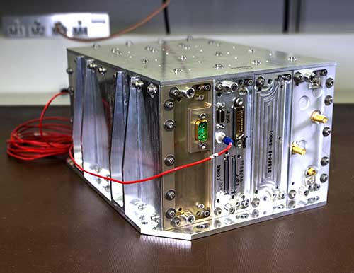
Building on NavCube
NavCube, which will be tested aboard the International Space Station later this year, is being used as a baseline for a lunar GPS receiver. (Photo: NASA/W. Hrybyk)
The team’s current lunar GPS receiver concept is based on NavCube, a new capability developed from the merger of MMS’s Navigator GPS and SpaceCube, a reconfigurable, very fast flight computer platform. The more powerful NavCube, developed with IRAD support, was recently launched to the International Space Station where it is expected to employ its enhanced ability to process GPS signals as part of a demonstration of X-ray communications in space.
The GPS processing power of NavCube combined with a receiver for lunar distances should provide the capabilities needed to use GPS at the Moon. Earlier this year, the team simulated the performance of the lunar GPS receiver and found promising results. By the end of this year, the team plans to complete the lunar NavCube hardware prototype and explore options for a flight demonstration.
“NASA and our partners are returning to the Moon for good,” Mitchell said. “NASA will need navigation capabilities such as this for a sustainable presence at the Moon, and we’re developing enabling technologies to make it happen.”
A report filed with NASA’s Aviation Safety Reporting System and published in June outlines how a passenger aircraft flew off course during a period of GPS jamming and nearly crashed into a mountain. Fortunately, an alert radar controller intervened, and the accident was averted.
Friedman Memorial Airport serves the ski resort town of Sun Valley, Idaho. Mountain peaks in the area are in excess of 12,000 feet. Airport arrival and departure procedures are carefully structured to ensure aircraft maintain safe distances from terrain.
According to the report, when “Aircraft X” arrived there was “…an abundance of smoke in the area” of the safe arrival route. Also “During this time there was widespread GPS jamming… Almost every aircraft was reporting…GPS outages.” Two previous flights had advised that their GPS signals were interrupted, but came back on line in time to make a safe approach to landing.
Aircraft X also reported problems with GPS, and then advised air traffic control that GPS had come back on line and was working well. The controller then cleared the aircraft for a GPS-based approach, including descending to 9,000 feet. Communications with and control of the aircraft was switched from Salt Lake Center (250+ miles away) to the tower at the local airport.
Shortly thereafter, the controller in Salt Lake City noticed Aircraft X straying off course. Also, it was at 10,700 feet altitude and nearing a 10,900 feet mountain. He quickly contacted the local control tower and the aircraft was directed back onto a safe flight path.
The report concludes that “Had [the Radar Controller] not noticed, that flight crew and the passengers would be dead, I have no doubt.”
Dana A. Goward is president of the Resilient Navigation and Timing Foundation.
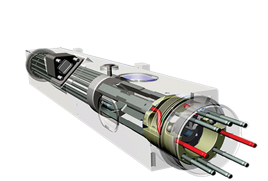
The National Aeronautic and Space Administration (NASA) is readying for an ultra-precise atomic clock that could not only transform the navigation of deep space missions, it could also improve the accuracy of GPS timing and thus GPS positioning. It is expected to launch in June.
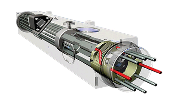
Drawing of the DSAC mercury-ion trap showing the traps and the titanium vacuum tube that confine the ions. The quadrupole trap is where the hyper-fine transition is optically measured and the multipole trap is where the ions are “interrogated” by a microwave signal via a waveguide from the quartz oscillator. (Image: NASA.)
The Deep Space Atomic Clock (DSAC) is a very small (the size of a toaster) mercury-ion atomic clock that is as stable as a highly precise ground atomic clock, yet small enough to fly aboard a spacecraft, and rugged enough to operate in deep space. Current ground-based atomic clocks that locate and navigate deep space missions are too massive to fly in space themselves.
Thus, tracking data from the far-flung spacecraft must be collected and processed on Earth, meaning a two-way tracking link. DSAC will enable NASA to improve tracking data precision by an order of magnitude for its deep space missions out to Jupiter, Saturn — and beyond.
It could also be used to improve the accuracy of GPS. DSAC is more stable and accurate than the atomic clocks currently aboard GPS satellites. As system modernization proceeds, use of a DSAC aboard future satellites holds out many promises. DSAC technology uses the property of mercury ions’ hyperfine transition frequency at 40.50 GHz to steer the frequency output of a quartz oscillator to a near-constant value.
The clock confines the mercury ions with electric fields in a trap and protects them by applying magnetic fields and shielding. It is anticipated that DSAC would produce only 1 microsecond of error over 10 years.
For further details on NASA’s Deep Space Atomic Clock project and detailed callouts on the diagram above, look here.
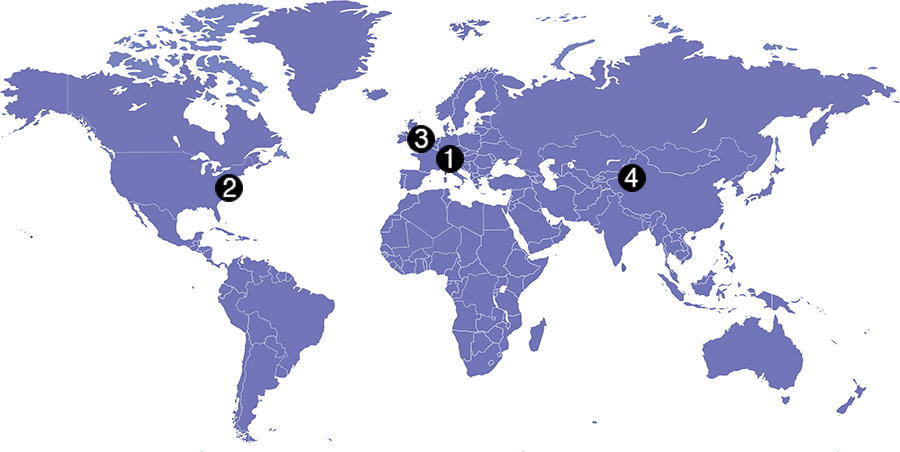
Check out some GPS developments that have recently taken place around the world. (Click to enlarge; Map: iStock.com/nadla)
1. A new use for GNSS satellites
University of Padua researchers say GNSS satellites make possible global quantum communication, beaming information between a satellite and an Earth-based ground station. They exchanged a single photon over 20,000 kilometers to prove secure quantum communications can be implemented on a global scale using GNSS. Results show the first exchange of a few photons per pulse between two GLONASS satellites, using the passive retro-reflectors mounted on the satellites, and the Space Geodesy Centre of the Italian Space Agency. The results could provide solutions for GNSS security for satellite-to-ground and inter-satellite links by using quantum information protocols for quantum key distribution.
Click to enlarge. (Photo: NASA)
2. GRITSS to improve reference frame
University of Massachusetts Lowell researchers have received a two-year, $1.2 million grant from NASA’s Earth Science Division to develop a Geodetic Reference Instrument Transponder for Small Satellites (GRITSS) to significantly improve the accuracy of the International Terrestrial Reference Frame — the basis of GPS positioning and navigation. A virtual map of the Earth, the ITRF pinpoints specific geographic positions and describes Earth’s precise shape, physical topography, orientation and rotation with time based on a stationary, Earth-centered coordinate system. The location of each GPS satellite is defined within the ITRF.
Click to enlarge. (Photo: Rick Thomas)
3. Pigeon scientists
Engineers from the University of Birmingham have developed a compact backpack to collect climate and pollution data. When the birds return to their lofts, the sensors are retrieved and the data downloaded, including GPS location, temperature, humidity, ambient light and air pressure. So far, scientists have been able to collect data from five birds — they made a total of 41 flights with a total length of about 1,000 kilometers.
Click to enlarge. (Photo: Victor Gevers/ZDNet)
4. China’s big brother program
Evidence that China is tracking its Uyghur Muslim population in the Xinjiang region has been uncovered. A facial recognition database was left open on the internet for months, Dutch security researcher Victor Gevers told ZDNet. The database contains information on 2.5 million people, along with a stream of GPS coordinates. Data includes detailed and sensitive information: names, ID card data, addresses, photos and employers, as well as GPS coordinates where the user had been seen via public cameras labeled mosque, hotel, police station, internet cafe, restaurant and more.
GPS signals extend farther than expected, meaning future space missions can reliably use GPS at extreme altitudes.
By Danny Baird
NASA’s Goddard Space Flight Center, Greenbelt, Maryland
The four Magnetospheric Multiscale (MMS) spacecraft recently broke the world record for navigating with GPS signals farther from Earth than ever before. MMS’ success indicates that NASA spacecraft may soon be able to navigate via GPS as far away as the Moon, which will prove important to the Gateway, a planned space station in lunar orbit.
After navigation maneuvers conducted this February, MMS now reaches over 116,300 miles from Earth at the highest point of its orbit, or about halfway to the Moon. At this altitude, MMS continued to receive strong enough GPS signals to determine its position, shattering previous records it set first in October 2016 and again in February 2017.
This demonstrates that GPS signals extend farther than expected and that future missions can reliably use GPS at extreme altitudes.
“At the first apogee after the maneuvers, MMS1 had 12 GPS fixes, each requiring signals from four GPS satellites,” said Trevor Williams, the MMS flight dynamics lead at NASA’s Goddard Space Flight Center in Greenbelt, Maryland. “When we began the mission, we had no idea high-altitude GPS would be such a robust capability.”
MMS’ orbit shift allows it to continue its mission to better understand the complex magnetic processes around Earth. MMS studies a fundamental process that occurs throughout the universe, called magnetic reconnection, in which magnetic fields collide and explosively release particles in all directions. Near Earth, reconnection is a key driver of space weather, the dynamic system of energy, particles and magnetic fields around Earth which can adversely impact communications networks, electrical grids and GPS navigation. Magnetic reconnection was long predicted by physicists, but not directly observed until the MMS mission.
To study Earth’s magnetosphere, the region of space dominated by the planet’s magnetic field, MMS spacecraft maintain a highly elliptical orbit around Earth. A highly elliptical orbit resembles a long oval around the globe with an extreme high point, or apogee, and low point, or perigee.
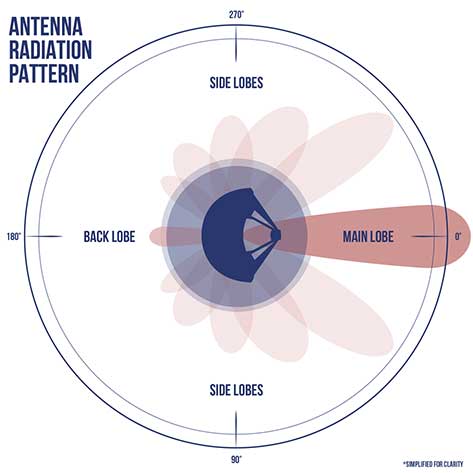
MMS’ tight formation and highly elliptical orbit require extremely accurate navigation data from GPS satellites, which are operated by the U.S. Air Force. The main GPS antenna signals enable navigation down on Earth, but precise high-altitude navigation requires both these as well as signals from the antenna’s side lobes. Side lobe signals radiate out to the side of the direction an antenna is pointing and extend past Earth.
A simplified antenna radiation pattern with different lobes of radiation extending from the antenna. (Image: NASA)
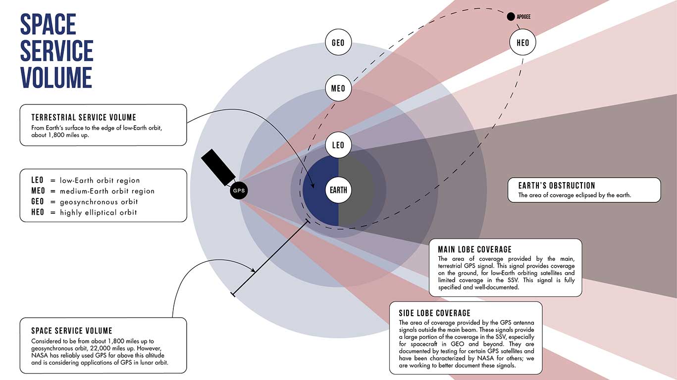
Communications engineers usually consider these side lobes wasted energy. However, the signals can be used by satellites at high altitudes on the opposite side of the globe as the GPS satellite. (Such high-altitude missions fly above GPS satellites’ orbit.) Previously, most engineers considered the upper limits of the GPS navigation in space to be an altitude of about 22,000 miles, or the altitude of satellites in geosynchronous orbit — until MMS.
Additionally, the navigation maneuvers allowed the spacecraft to gather data not available to scientists during normal operations.
“MMS usually flies in a close, tetrahedral formation [that looks like a pyramid],” said Thomas Moore, the project scientist for MMS at Goddard. “During the orbit-raising maneuvers, the spacecraft became a [straight line or] ‘string of pearls,’ which gave us unique data about the magnetosphere that may further our understanding of magnetic reconnection.”
MMS’ tight configuration and record-breaking GPS fixes would not be possible without the mission’s Navigator GPS receiver, an instrument developed at Goddard. It can detect faint GPS signals while withstanding the harsh radiation environment within the magnetosphere. NASA has made this revolutionary technology available for licensing through the Technology Transfer program, ensuring that commercial enterprise can also benefit from this innovation.
A diagram showing how GPS antenna signals can serve spacecraft at high altitudes. (Image: NASA)
In fact, NASA simulations show GNSS signals could even be used for reliable navigation in lunar orbit, just as a car uses GPS on an interstate highway. Engineers are considering using GNSS signals in the navigation architecture for the Gateway, an outpost in orbit around the Moon that will enable sustained lunar surface exploration.
“We’re working with the international community to document GNSS performance for space users, including side lobe signals,” said Joel Parker, a Goddard navigation engineer representing NASA internationally in GNSS policy. “A better understanding of GNSS capabilities will allow high-altitude missions to take advantage of the robust navigation signals they provide.”
Illustration of the four MMS spacecraft in orbit in Earth’s magnetic field. (Image: NASA).
Thanks to MMS and NASA’s navigation engineers, the sky is no longer the limit.
NASA’s Science Mission Directorate provides strategic oversight to MMS. Goddard’s Explorers and Heliophysics Projects Division manages the mission. The four MMS spacecraft launched on March 13, 2015, from NASA’s Kennedy Space Center in Cape Canaveral, Florida, on board an Atlas V launch vehicle.
NASA’s Space Communications and Navigation (SCaN) program office oversees the agency’s work in navigation policy related to GNSS. NASA, consulting the United Nations International Committee on GNSS (ICG), collaborates with other U.S. agencies and the six international GNSS providers to define GNSS requirements and develop additional capabilities. The team of SCaN navigation specialists charged with aiding the ICG are based out of the Exploration and Space Communications projects division at Goddard.
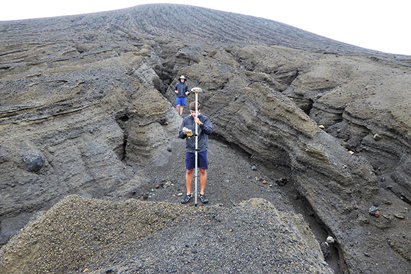
A new island near Tonga has officially been surveyed, courtesy of Goddard NASA scientist Dan Slayback.
Most new islands vanish as fast as they appear from punishing ocean waves, but this one is different. It’s one of only three volcanic islands to live longer than a few months in the past 150 years, and the first survivor since satellites began collecting Earth imagery.
“There’s no map of the new land,” Slayback said. The island, nestled between two older islands, erupted from the rim of an underwater caldera in early 2015. The older islands were on some nautical charts at coarse resolution.
Slayback has been watching the island via satellite since its birth, trying to make a 3D model of its shape and volume as it changes over time to understand how much material has been eroded and what it is made of that makes it partially resistant to erosion. But while high-resolution satellite observations provide some data, nothing beats a visit.
On Oct. 9, 2018, Slayback and students with the Sea Education Association (SEA) measured the location and elevation of boulders and other erosional features visible in the satellite image. Using a high-precision GPS unit with a rover and base station, Dan and the students took about 150 measurements that narrow down each point’s location and elevation to better than 10 centimeters. They also used a drone to conduct an aerial survey of the island for another layer of observations to make a high-resolution 3D map.
The elevation changes were more dramatic than Slayback expected. The data that the team gathered on the ground will help scientists hone the model they use to convert satellite images to ground heights, according to NASA.
NASA scientists are keen to understand how new islands form and evolve on Earth; the knowledge may provide clues about how volcanic landscapes interacted with water on ancient Mars.