Registration has opened for the 35th Space Symposium, sponsored by the Space Foundation and taking place April 8-11 in Colorado Springs, Colorado. The Space Symposium provides a forum to discuss, address and plan for future achievements in space.
According to show organizers, the event represents all sectors of the space community from multiple spacefaring nations, including space agencies; commercial space businesses and associated subcontractors; military, national security and intelligence organizations; cyber security organizations; federal and state government agencies and organizations; research and development facilities; think tanks; educational institutions; space entrepreneurs and private space travel providers; businesses engaged in adapting, manufacturing or selling space technologies for commercial use; and media that inspire and educate the general public about space.
The event will feature a number of speakers from NASA, Raytheon, the U.S. Air Force, the Canadian Space Agency, the Mexican Space Agency, the Korean Aerospace Research Institute and more.
Attendees can also choose from a number of sessions, as well as purchase tickets for a variety of networking opportunities, including the Corporate Partnership Dinner, General James E. Hill Lifetime Space Achievement Award Luncheon, Women’s Global Gathering Luncheon and Space Technology Hall of Fame Luncheon.
The Advanced Rapid Imaging and Analysis (ARIA) team at NASA’s Jet Propulsion Laboratory in Pasadena has produced a map showing the damage caused by the Camp Fire in Northern California.
After two and a half weeks of historic destruction, the fire is now 100 percent contained. Teams continue to search the destruction — including the destroyed town of Paradise — for remains. As of Sunday, the death toll is 85, making it California’s deadliest fire.
The map shows the damage as of Nov. 16.
Credits: NASA/JPL-Caltech
The map was developed using synthetic aperture radar images from the Copernicus Sentinel-1 satellites operated by the European Space Agency.
The map covers an area of 48 miles by 48 miles (78 by 77 kilometers), outlined in red on left. A closeup view of damage to the town of Paradise is inset on right, outlined in white. The color variation from yellow to red indicates increasingly more significant changes in the ground surface.
The ARIA team creates its maps by comparing before-and-after satellite images of the fire region to see the extent of change between the two images. For this map, they compared the data for the image to a Cal Fire map for preliminary validation.
Although the maps may be less reliable over vegetated terrain, such as forests, they can help officials and first responders identify heavily damaged areas and allocate resources as needed.
Sentinel-1 data were accessed through the Copernicus Open Access Hub. The image contains modified Copernicus Sentinel data (2018), processed by ESA and analyzed by the NASA-JPL/Caltech ARIA team.
NextNav’s Metropolitan Beacon System (MBS) service has been accepted for use by NASA. NASA will use NextNav’s MBS network as part of its CERTAIN (City Environment for Range Testing of Autonomous Integrated Navigation) facilities at NASA’s Langley Research Center in Hampton, Virginia.
CERTAIN supports, among other programs, Urban Air Mobility (UAM), an air transportation system with myriad applications from small package delivery drones to passenger-carrying air taxis.
The Federal Aviation Administration (FAA) believes that by 2022 there will be more than 700,000 drones delivering packages, monitoring traffic and aiding in search and rescue operations. NASA’s role is to provide research findings to reduce technical barriers associated with integrating unmanned aircraft systems into the national airspace system.
NextNav’s MBS system facilitates urban drone operations where satellite-based GPS signals may not be available. The need to reliably know a drone’s location horizontally and vertically is critical to ensure safe operations in urban air traffic corridors.
Uber in the Mix. Uber and Bell (formerly Bell Helicopter) plan to launch an on-demand mobility venture, or flying taxis, nationwide by 2023, so the need to precisely track vehicles moving throughout city airspace is imminent.
The move to such flying taxis would require a change to current FAA-controlled airspace separation requirements, according to Tom Prevot, Uber’s director of airspace systems. He stated that the Uber venture foresees takeoffs and landings from city vertiports every 24 seconds, requiring a considerable reduction in the minimum-distance standards of 1,000 feet vertically or 3 to 5 nm horizontally, as currently mandated in FAA order JO 7110.65.
Metro Beacons. “NextNav’s MBS system provides us with new tools for the development of navigation systems in environments where GPS has traditionally been challenged,” said Evan Dill, Safety-Critical Avionics Systems Branch of NASA. “We’re looking forward to working with MBS as we develop new approaches to the operation of unmanned systems in urban environments.”
NextNav’s wide-area terrestrial positioning network provides accurate and secure location services, critical for unmanned aircraft navigation. In addition, MBS complements and integrates seamlessly with GPS and provides a level of geo-redundancy ensuring a safe and efficient system for future air transportation in cities and urban areas, with particularly difficult challenges at low altitudes where solutions such as radar, GPS and ADS-B are unreliable or insufficient.
Delivered over a managed network on nationwide licensed spectrum with carrier-grade dependability and metropolitan-wide coverage, NextNav said its services are designed for public safety applications, E911, critical infrastructure, as well consumer, Internet of Things (IoT) and commercial applications that require reliable 3D geolocation indoors and urban areas or precise timing.
Future city airspace filled with drones and passenger aircraft. (Image: NASA)
“We are proud to work with NASA and integrate MBS into its urban drone operations,” said Ganesh Pattabiraman, co-founder and CEO of NextNav. “The MBS system is designed for secure, reliable and consistent 3D geolocation capabilities, which are important for autonomous systems such as drones. NASA’s acquisition of the MBS system is an exciting milestone for MBS technology and a great partnership with NASA to address the key challenges in urban drone navigation and make it possible to explore new opportunities in unmanned operations.”
Researchers from NASA’s Frontier Development Lab (FDL) and Intel are proposing a way to navigate on a new planet using artificial intelligence (AI).
The researchers presented their planetary navigation research during an Intel event on Aug. 16.
The immense challenge of building GPS-similar constellations around every planet or moon could be avoided by using imagery, according to researchers Andrew Chung, Philippe Ludivig, Ross Potter and Benjamin Wu.
The team developed a system for simulating the Moon’s surface so that AI could be used for navigation on the surface.
How It Works. The researchers created a highly detailed digital model of a virtual moon using 2.4 million images of its surface. The images represent ones that might be taken by a rover.
The AI learned what this moon looks like by being fed the millions of images, and then used its neural network to create a model of the virtual moon.
According to the team’s presentation, this was enough to effectively enable navigation on the virtual moon’s surface.
With the model in place, a person merely needs to take a photo of their surroundings on the surface. Based on the photo, the AI determines the person’s location and shows how to navigate to a destination. The AI would even understand the distortions of known features from the point of view of the camera.
The team wants to try to do the same thing with a real celestial body: Mars. They think they have enough satellite images to make it work.
If they’re right, the first Martian visitors could navigate the Red Planet by photo.
The National Space-Based Positioning, Navigation, and Timing Advisory Board (PNT Board) will take part in a public teleconference on spectrum issues on Aug. 6.
The meeting will be held via teleconference and WebEx. The teleconference will take place Monday, August 6, from, 12-4 p.m. Eastern Time.
This meeting will be open to the public telephonically and by WebEx. Any interested person can call the toll-free (in the U.S.) conference-call number at 1–844–467–4685 or the local toll number at 1–720–259–7012 using passcode: 106724 to participate in the meeting by telephone.
The WebEx link is https://nasa.webex.com/, the meeting number is 995 034 805, and the password is uuU7bDX* (case sensitive).
This meeting was agreed to at the 21st session of the National Space-Based PNT Advisory Board, held May 16–17 in Baltimore. The public can follow the discussions by dial-in or the web link provided.
The agenda includes the following topics:
Finalize and approve the National Space-Based PNT Advisory Board topics paper
Finalize and approve the National Space-Based PNT Advisory Board Memorandum on Spectrum Issues to the National Space-Based PNT Executive Committee, Carol J. Hamilton, acting advisory committee management officer, NASA.
Did you know Australia doesn’t exist? (Sorry, Aussies.) The entire continent is part of a massive conspiracy designed to confuse you. Anyone who says they’re from Australia is an actor (paid by NASA, probably.) And all the airline pilots are “in on it,” flying people to a carved out section of South America.
The “rationale” (I use the word very lightly) seems to be that Britain just wanted to dump its convicts in the ocean, so made up the continent to tell people where they were taking them.
These and other “theories” spouted by Flat Earthers are akin to falling down a rabbit hole where up is down and round is flat. How can they believe such nonsense?
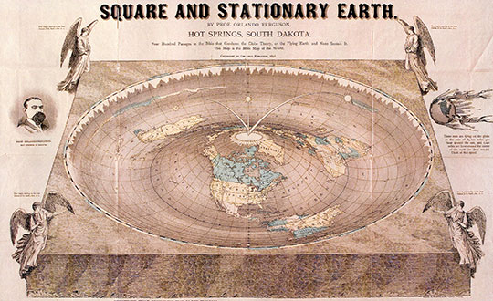
The 1893 Orlando Ferguson map imagines Antarctica as a wall of ice around the world. (Image: Library of Congress/2011594831)
Last year, the flat Earth idea became national news when rapper B.o.B. used Twitter to jump on the flat Earth bandwagon, even starting a GoFundMe campaign to find Earth’s curve. B.o.B.’s campaign wants to “launch multiple weather balloons and satellites into space” to observe (and try to disprove) what centuries of science and technology have already confirmed. So far, he’s raised less than $7,000 of his $1 million target.
How do Flat Earthers explain GPS? Is there a way to convince them that they’re wrong? Probably not. Anyone who tries is met with an argument that their evidence is faked or faulty. GPS satellites aren’t in space — there’s a “celestial dome” over the Earth. Or the signals are really from giant towers and the G stands for ground. Or Google has laid cables across the oceans to track you.
Astrophysicist Neil DeGrasse Tyson blames the educational system — not for teaching insufficient science subjects so much as needing to improve critical thinking skills. “Our system needs to train you not only what to know, but how to think about information, knowledge and evidence,” he said.
Should we bother to convince Flat Earthers they’re wrong? Some on the internet could be trolls toying with arguments and theories. True believers, however, are an extreme minority, and there will always be people who choose to believe in “alternative facts.” Let’s hope they remain a minority.
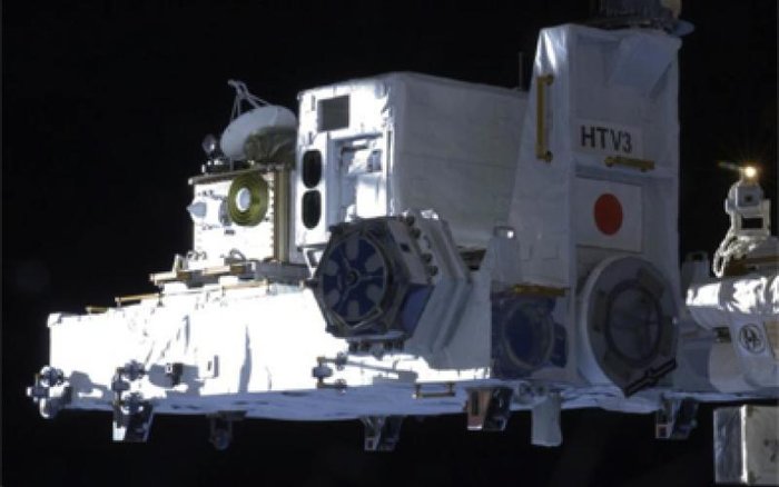
Europe’s satellite navigation system Galileo is already in use worldwide, usable by itself or in combination with the U.S. GPS. Now a combined Galileo–GPS positioning fix has been achieved in space — aboard the International Space Station — through an ESA–NASA collaboration.
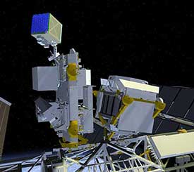
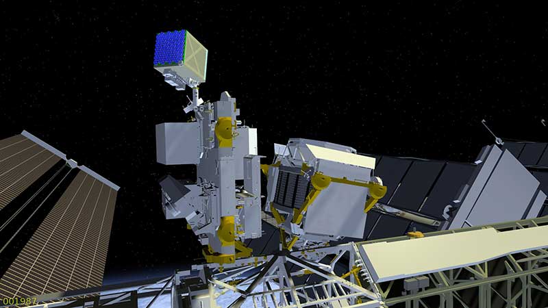
In April, the chest-sized SCaN (seen left of center with an antenna on top) was used to make the first combined Galileo-GPS positioning fix in orbit from the ISS. (Photo: ISS)
Low-Earth orbiting satellites routinely make use of satellite navigation signals to pinpoint their position in space and allow their paths through space to be fixed with extremely high accuracy, known as “precise orbit determination.”
So far, such positioning has mainly been performed using GPS, but this new test proves it can also be achieved on a dual-constellation basis with both GPS and Galileo — as well as through the sole use of Galileo.
The experiment is based on the use of a reconfigurable NASA receiver called the Space Communications and Navigation Testbed, SCaN, attached to the exterior of the ISS.
ESA’s Navigation Support Office, based at its ESOC control centre in Darmstadt, Germany, teamed up with its Radio Navigation Systems and Technology team, located at its ESTEC technical centre in Noordwijk, the Netherlands, and Italy’s Qascom company to develop the techniques, software and firmware required for the experiment, which was passed to NASA’s Glenn Research Center in Ohio for upload to the receiver.
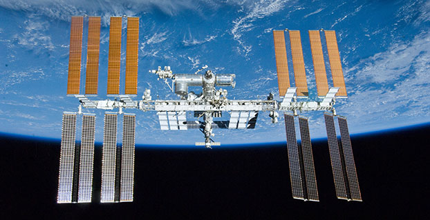
The International Space Station. (Photo: ESA)
“SCaN is a versatile software-defined radio receiver in space for both telecommunications and navigation testing, delivered to the Station back in 2012,” said ESA radio-navigation engineer Pietro Giordano. “It made it possible, with suitable modifications, to demonstrate combined GPS-Galileo positioning determination of the ISS.”
The algorithm developed for the SCaN Testbed had to take account of the high dynamics involved, and resulting Doppler shifting of signals: not only are the Galileo and GPS satellites moving at orbital velocity, so is the ISS itself. Orbital information of all the satellites in both constellations was included in the algorithm, allowing SCaN to make a ‘warm start’ – to search out signals in the correct segments of the sky.
In February 2006, the Navigation Support Office inaugurated its modern Navigation Facility at the European Space Operations Center (ESOC) in Darmstadt, Germany. (Photo: ESA)
In February 2006, the Navigation Support Office inaugurated its modern Navigation Facility, at the European Space Operations Center (ESOC), in Darmstadt, Germany.
“Dual constellation fixes offer many advantages for space, providing extremely robust and high-precision positioning,” Pietro added. “More signals become available overall, and the quality of the Galileo Open service and modernised GPS signals are extremely good.”
Werner Enderle, overseeing the project at the Navigation Support Office noted, “These excellent first results, coming out of great teamwork within ESA, collaboration with industry and with our NASA partners, mark just the beginning of our project data analysis. Many other exciting results are expected related to signal aspects, precise orbit determination and positioning based on optimised algorithms.”
James J. Miller, GPS Sr. Technologist within the SCaN programme office at NASA Headquarters, commented: “We’ve been promoting interoperability of GPS and Galileo through a number of activities within the United Nation’s International Committee on Global Navigation Satellite Systems (GNSS). In particular, NASA, with ESA and other national space agencies, has been identifying benefits to be gained for high altitude users in the multi-GNSS Space Service Volume under development. By further demonstrating multi-GNSS capabilities in low Earth orbit, the drive for additional utility at geostationary orbit and beyond is only strengthened.”
Europe’s Galileo system began Initial Services for users in December 2016, and there are 22 Galileo satellites in orbit. The launch of four more Galileo satellites by Ariane 5 is scheduled for July 25, and will bring the constellation to 24 satellites plus two orbital spares.
ESA is developing dual Galileo-GPS receivers for the next generation of Earth-observing Sentinel satellites. The more precise the orbit determination, the more accurate the environmental data that can be returned to Earth.
Combined use of Galileo and GPS signals on an interoperable basis for positioning and precise orbit determination should bring significant advantages for space users in particular, set to provide a seamless navigation capability from low to high Earth orbits — and potentially beyond.
“This shows the versatility of the Galileo system and the use of the system for scientific and other purposes, way beyond traditional navigation services,” said Paul Verhoef, ESA’s Director of Navigation. “We have also started work to determine whether we can use Galileo, in combination with GPS and other systems, for navigation to the Moon.”
The Nevada Institute for Autonomous Systems (NIAS) and its NASA Unmanned Traffic Management (UTM) partners flew multiple unmanned aerial systems over a week-long testing period at the Nevada UAS Test Site at the Reno-Stead Airport.
NASA UTM Testing. Credit: NIAS. (PRNewsfoto/Nevada Institute for Autonomous)
This third phase of NASA’s UAS testing (TCL 3) again focused on airspace management technologies that will enable the safe integration of UAS into the national airspace.
NASA provided a Flight Information Management System (FIMS) research platform that will serve as a future prototype system for the U.S. Federal Aviation Administration (FAA) to use to coordinate with unmanned service suppliers operating throughout the nation.
Research areas of emphasis during the testing included UAS ground-control interfacing to locally manage operations, communication, navigation, surveillance, human factors, data exchange, network solutions and beyond-visual-line-of-sight (BVLOS) architecture.
On media day, a team from the Reno Fire Department simulated an incident with a victim experiencing severe blood loss and who needed an immediate transfusion. A multi-rotor UAS from Drone America was equipped with a container that held an actual packet of blood to be transported via drone in Nevada.
High winds and frigid temperatures tested both the drone and those on the ground, but the drone successfully landed in the designated landing area so that firefighters could retrieve the blood packet and begin the faux-transfusion.
The partners not only demonstrated drone flight capability, but also tested UAS traffic mapping and sensor and radar technology, all of which were connected through a NASA UAS Service Supplier (USS) network to NASA Ames.
Technology Capability Levels
NASA’s near-term goal is the development and demonstration of a possible future UTM system that could safely enable low-altitude airspace and UAS operations. Working alongside many committed government, industry and academic partners, NASA is leading the research, development and testing that is taking place in a series of activities called “Technology Capability Levels (TCL)”, each increasing in complexity.
UTM TCL1 concluded field testing in August 2015 and is undergoing additional testing at an FAA site. Technologies in this activity addressed operations for agriculture, firefighting and infrastructure monitoring, with a focus on geofencing, altitude “rules of the road” and scheduling of vehicle trajectories.
UTM TCL2, completed in October 2016, leveraged TCL1 results and focused on beyond visual line-of-sight operations in sparsely populated areas. Researchers tested technologies that allowed dynamic adjustments to availability of airspace and contingency management.
UTM TCL3, just completed, leveraged TCL2 results and focused on testing technologies that maintain safe spacing between cooperative (responsive) and non-cooperative (non-responsive) UAS over moderately populated areas.
UTM TCL4, with dates to be determined, will leverage TCL3 results and focus on UAS operations in higher density urban areas for tasks such as news gathering and package delivery. It will also test technologies that could be used to manage large-scale contingencies.
NASA’s UTM technologies research and development is taking place in collaboration with the FAA. Results of research in the form of airspace integration requirements are expected to be transferred from NASA to the FAA in 2019 for the FAA’s further testing.
“Advanced flight and highly technical scenarios like drone detection, surveillance of critical infrastructure aerial package delivery of critical first responder medical supplies, to the important NASA data interoperability protocols that will eventually form the backbone of the UTM system, we focused heavily on communications, navigation and surveillance to produce critical data for the NASA TCL 3 Campaign,” said Chris Walach, the senior director of NIAS and the FAA-designated Nevada UAS Test Site. “Our Nevada teammates did an amazing job working together to successfully complete the first series of major testing for NASA’s TCL 3 Campaign.”
Neutron-star Interior Composition Explorer, or NICER, is an external attached payload on the International Space Station. (Image: NASA Goddard Space Flight Center)
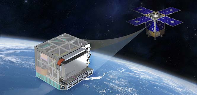
A team of engineers at the U.S. National Aeronautics and Space Administration (NASA) has demonstrated fully autonomous X-ray navigation in space — a capability that could enable robotic spacecraft to navigate beyond the edges of the solar system.
The experiment, Station Explorer for X-ray Timing and Navigation Technology (SEXTANT), showed that millisecond pulsars could be used to accurately determine the location of an object moving at thousands of miles per hour in space, functioning in a way similar to GPS.
The system provides a new option for spacecraft to autonomously determine their locations outside Earth-based global navigation networks because pulsars are accessible in virtually every conceivable flight regime, from low-Earth to deepest space.
The SEXTANT demonstration used the 52 X-ray telescopes and silicon-drift detectors that make up NASA’s Neutron-star Interior Composition Explorer (NICER), an external attached payload on the International Space Station.
The size of a washing machine, NICER studies neutron stars, which emit radiation across the electromagnetic spectrum. Incredibly dense — one teaspoonful of neutron star matter would weigh a billion tons on Earth — these objects would collapse into black holes if compressed any further.
Pulsars. The SEXTANT experiment focuses on a particular type of neutron star: pulsars, highly magnetized, rotating neutron stars. Their electromagnetic radiation can be observed only when the beam of emission points toward Earth, thus their pulsed appearance. The short, regular rotational period produces a precise interval between pulses that ranges from milliseconds to seconds for an individual pulsar. These predictable pulsations can provide high-precision timing information similar to the atomic-clock signals supplied through GPS.
Demonstration. A demonstration in November 2017 selected four millisecond pulsar targets — J0218+4232, B1821-24, J0030+0451 and J0437-4715 — and directed NICER to orient itself so it could detect X-rays within their sweeping beams of light. These millisecond pulsars are so stable that their pulse arrival times can be predicted to accuracies of microseconds for years into the future.
During the two-day experiment, the payload generated 78 measurements to get timing data, which the SEXTANT experiment fed into its onboard algorithms to autonomously stitch together a navigational solution that revealed the location of NICER in its orbit around Earth. The team compared that solution against location data gathered by NICER’s onboard GPS receiver.
“For the onboard measurements to be meaningful, we needed to develop a model that predicted the arrival times using ground-based observations provided by our collaborators at radio telescopes around the world,” said Paul Ray, a SEXTANT co-investigator with the U.S. Naval Research Laboratory. “The difference between the measurement and the model prediction is what gives us our navigation information.”
The goal was to demonstrate that the system could locate NICER within a 10-mile radius as the space station sped around Earth at slightly more than 17,500 mph. Within eight hours of starting the experiment on Nov. 9, the system converged on a location within the targeted range of 10 miles and remained well below that threshold for the rest of the experiment. In fact, a good portion of the data showed positions that were accurate to within three miles.
GPS-level accuracy on the order of a meter or less is not necessary when navigating the far reaches of the solar system, where distances between objects measure in the millions of miles. “In deep space, we hope to reach accuracies in the hundreds of feet,” said Mitchell.
The team will now focus on updating and fine-tuning both flight and ground software in preparation for a second experiment later in 2018. The ultimate goal, which may take years to realize, is to develop detectors and other hardware to make pulsar-based navigation readily available on future spacecraft.
To advance the technology for operational use, teams will focus on reducing the size, weight and power requirements and improving the sensitivity of the instruments. The SEXTANT team now also is discussing the possible application of X-ray navigation to support human spaceflight.
If an interplanetary mission to the moons of Jupiter or Saturn were equipped with such a navigational device, for example, it would be able to calculate its location autonomously, for long periods of time without communicating with Earth.
“This successful demonstration firmly establishes the viability of X-ray pulsar navigation as a new autonomous navigation capability,” said project manager Jason Mitchell. “We have shown that a mature version of this technology could enhance deep-space exploration anywhere within the solar system and beyond.”
While in orbit, the Deep Space Atomic Clock (DSAC) mission will use the navigation signals from GPS coupled with precise knowledge of GPS satellite orbits and clocks to confirm DSAC’s performance.
News from the Jet Propulsion Laboratory, NASA
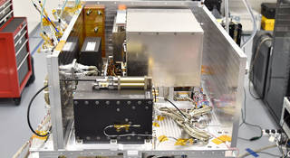
In deep space, accurate timekeeping is vital to navigation, but many spacecraft lack precise timepieces on board. For 20 years, NASA’s Jet Propulsion Laboratory in Pasadena, California, has been perfecting a clock. It’s not a wristwatch; not something you could buy at a store. It’s the Deep Space Atomic Clock (DSAC), an instrument perfect for deep space exploration.
The atomic clock, GPS receiver and ultra-stable oscillator that make up the Deep Space Atomic Clock Payload, following integration into the middle bay of Surrey Satellite US’s Orbital Test Bed Spacecraft. (Photo: Surrey Satellite Technology)
Currently, most missions rely on ground-based antennas paired with atomic clocks for navigation. Ground antennas send narrowly focused signals to spacecraft, which, in turn, return the signal. NASA uses the difference in time between sending a signal and receiving a response to calculate the spacecraft’s location, velocity and path.
This method, though reliable, could be made much more efficient. For example, a ground station must wait for the spacecraft to return a signal, so a station can only track one spacecraft at a time. This requires spacecraft to wait for navigation commands from Earth rather than making those decisions on board and in real-time.
“Navigating in deep space requires measuring vast distances using our knowledge of how radio signals propagate in space,” said Todd Ely of JPL, DSAC’s principal investigator. “Navigating routinely requires distance measurements accurate to a meter or better. Since radio signals travel at the speed of light, that means we need to measure their time-of-flight to a precision of a few nanoseconds. Atomic clocks have done this routinely on the ground for decades. Doing this in space is what DSAC is all about.”
The Deep Space Atomic Clock in the middle bay of the General Atomics Orbital Test Bed spacecraft. (Image: NASA)
The DSAC project aims to provide accurate onboard timekeeping for future NASA missions. Spacecraft using this new technology would no longer have to rely on two-way tracking. A spacecraft could use a signal sent from Earth to calculate position without returning the signal and waiting for commands from the ground, a process that can take hours. Timely location data and onboard control allow for more efficient operations, more precise maneuvering and adjustments to unexpected situations.
This paradigm shift enables spacecraft to focus on mission objectives rather than adjusting their position to point antennas earthward to close a link for two-way tracking.
Additionally, this innovation would allow ground stations to track multiple satellites at once near crowded areas like Mars. In certain scenarios, the accuracy of that tracking data would exceed traditional methods by a factor of five.
DSAC is an advanced prototype of a small, low-mass atomic clock based on mercury-ion trap technology. The atomic clocks at ground stations in NASA’s Deep Space Network are about the size of a small refrigerator. DSAC is about the size of a four-slice toaster, and could be further miniaturized for future missions.
The DSAC test flight will take this technology from the laboratory to the space environment. While in orbit, the DSAC mission will use the navigation signals from U.S. GPS coupled with precise knowledge of GPS satellite orbits and clocks to confirm DSAC’s performance. The demonstration should confirm that DSAC can maintain time accuracy to better than two nanoseconds (.000000002 seconds) over a day, with a goal of achieving 0.3 nanosecond accuracy.
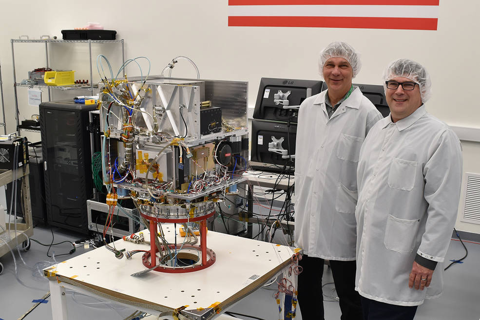
Tom Cwik, the head of JPL’s Space Technology Program (left) and Allen Farrington, JPL DSAC project manager, view the integrated atomic clock payload on Surrey Satellite US’s Orbital Test Bed Spacecraft. (Photo: Surrey Satellite Technology)
Once DSAC has proved its mettle, future missions can use its technology enhancements. The clock promises increased tracking data quantity and improved tracking data quality. Coupling DSAC with onboard radio navigation could ensure that future exploration missions have the navigation data needed to traverse the solar system.
Technologies aboard DSAC could also improve GPS clock stability and, in turn, the service GPS provides to users worldwide. Ground-based test results have shown DSAC to be upwards of 50 times more stable than the atomic clocks currently flown on GPS. DSAC promises to be the most stable navigation space clock ever flown.
“We have lofty goals for improving deep space navigation and science using DSAC,” said Ely. “It could have a real and immediate impact for everyone here on Earth if it’s used to ensure the availability and continued performance of the GPS system.”
DSAC is a partnership between NASA’s Space Technology Mission Directorate and the Space Communications and Navigation program office, a program under the Human Exploration and Operations Mission Directorate. DSAC will launch in 2018 as a hosted payload on General Atomic’s Orbital Test Bed spacecraft aboard the U.S. Air Force Space Technology Program (STP-2) mission.
The northernmost Joint Polar Satellite System Common Ground System station in Svalbard, Norway. (Photo: Raytheon)
Newest version of Raytheon’s Joint Polar Satellite System Common Ground System is now operational
Raytheon’s next-generation Common Ground System for the Joint Polar Satellite System (JPSS CGS 2.0) is now operational, supporting 11 polar-orbiting satellites and delivering observations to NOAA’s National Weather Service almost 50 percent faster than before.
Svalbard, Norway, is the location of the northernmost Joint Polar Satellite System Common Ground System station.
JPSS CGS 2.0 was designed to support the upcoming NASA launch of NOAA’s JPSS-1 satellite on Nov. 14.
“The new ground system significantly improves the mission capabilities of the JPSS program,” said Matt Gilligan, vice president of Raytheon’s Navigation and Environmental Solutions. “It can handle even more data from the full constellation of satellites now and in the future.”
Developed by NASA for NOAA, the JPSS CGS collects and disseminates observations from polar-orbiting weather satellites from the United States, Europe and Japan.
The polar orbiters provide critical weather and environmental data to ensure meteorologists and forecasters have robust, reliable information to make timely and accurate weather predictions that help save lives, protect property and decrease the devastating economic impact caused by severe weather.
Telephonics Corporation’s subsidiary, Systems Engineering Group (SEG), will demonstrate autonomous UAV control and PULSEbox this month during the Annual Naval Technology Exercise (ANTX), Dahlgren (Virginia) Division event.
ANTX-Dahlgren, being held Sept. 13-14, is a two-day event providing a low-risk environment to evaluate technological innovations at the research and development level before technologies become militarized and integrated at the operational level.
The autonomous UAV control demonstration will include a system manager in a UAV control ConOps scenario. System Manager is a model-based expert system of systems, which can plan, schedule and initiate ConOps processes to provide round the clock automation in the Flight Dynamics Operations Area (FDOA) on NASA’s Magnetospheric Multiscale (MMS) mission. This enables NASA to minimize human involvement in controlling satellite maneuvers along with optimizing data downloads.
PULSEbox offers a high fidelity, real-time, RF threat scene generator that integrates SEG’s threat models with optimized hardware. The system will create advanced test ecosystems by providing real-world target simulated threat states and related radar representations in laboratory settings, leading to improved testing of interoperable elements before live-sea testing events of air-breathing and ballistic missile threats, the company said.
“Both the autonomous UAV control and PULSEbox technologies align with the U.S. Navy’s requirements for more autonomous systems with limited human control requirements and more realistic training, simulation and modeling environments,” said Michael Anderson, Telephonics vice president and SEG general manager.