Seen & Heard is a monthly feature of GPS World magazine, traveling the world to capture interesting and unusual news stories involving the GPS/GNSS industry.
Photo: Mount Everest/Daniel Prudek/Shutterstock.com
Surveying the highest height
The precise height of Mount Everest — now listed as 29,029 feet, or 8,848 meters — has been contested since the first survey by British officers in 1849.
On January 2020, Nepal plans to end the controversy and declare both snow and rock height of the world’s tallest mountain. This spring a two-member Nepali survey team will summit the mountain with a Trimble R10 GNSS receiver, gifted by New Zealand.
Besides a GNSS survey at the summit, teams will conduct precise leveling, trigonometric leveling and gravity surveys. The GNSS survey will cover 285 points with 12 different observation stations, nine of which are in hills of Sankhuwasava, Bhojpur and Solukhumbu districts.
Photo: e-Golf cars/Volkswagen
Takin’ it to the (Hamburg) streets
Five electric Volkswagen Golfs are now on the streets of Hamburg, Germany, being tested with Level 4 automation.
The cars are designed to handle complex urban traffic patterns without help from drivers, although they must be ready to intervene.
Level 5, the highest category, requires the vehicle to perform all tasks, turning every rider into a passenger.
The cars are driving 1.9 miles (3 km) of urban roads where new signals and traffic management systems have been installed for autonomous driving.
Boeing 787 Dreamliner Hainan airlines/aapsky/Shutterstock.com
GPS Rollover gone wrong
The April 6 GPS Week Number Rollover was supposed to pass without a hitch, with plenty of notice that updates might be required for legacy receivers. Instead, several systems crashed.
In China, as many as 15 Boeing 777s and 787s were grounded pending a GPS update (the receivers gave the date as August 22, 1999.)
In New York City, part of the wireless grid faulted, cutting information feeds to the NYPD (license plate cameras) and remote worksite communications.
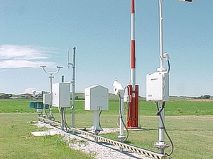
In Australia, weather balloons were grounded. In the United States, NOAA autonomous monitoring stations went offline. Fixes for all these systems are underway.
The GPS Week Number Rollover, which took place April 6, has caused several automated NOAA stations to go offline.
Some of the outages could last until November.
Photo: NOAA
According to the EOS website, 19 National Oceanic and Atmospheric Administration (NOAA) coastal and marine automated stations were not updated to mitigate the issue, and those stations are out of commission until workers can service them on location.
The New York Times is reporting that at 7:59 p.m. EDT on Saturday, the New York City Wireless Network went dark, interrupting functions such as the collection and transmission of information from some Police Department license plate readers, Department of Transportation traffic-light programming, and communications at remote work sites for the sanitation and parks departments.
The city is now working overtime to bring affected systems back online, reports StateScoop.
Previously, GPS World reported on rollover issue for the Australian Bureau of Meteorology’s (BOM) weather balloons, as well as Boeing aircraft. Read more about the Boeing issue here.
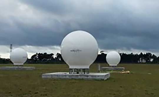
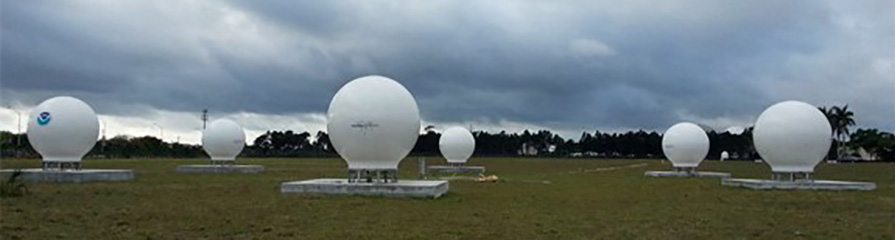
Orolia has successfully installed the first operational Cospas-Sarsat second-generation technology on search-and-rescue ground stations for the National Oceanographic and Atmospheric Administration (NOAA) in Florida and Hawaii.
The ground stations have been upgraded with second-generation beacon (SGB) signal-processing capabilities to more accurately and quickly locate the source of distress signals.
The NOAA Florida and Hawaii ground stations are the only operationally ready Medium Earth Orbit Search and Rescue (MEOSAR) ground stations in the world to receive the SGB signal specification capability.
The Cospas-Sarsat global search-and-rescue system developed specifications for the second-generation 406-MHz search-and-rescue beacon, which uses a modern, spread-spectrum signal to achieve more accurate and robust performance.
“The work performed by Orolia was exceptional, as the process of upgrading an operational system to a higher set of requirements, years after its initial design, involves minimizing downtime while validating the new requirements and revalidating the previous requirements,” said Mickey Fitzmaurice, NOAA SARSAT Systems Engineer. “The successful result makes it obvious that the engineering and operations team at Orolia put a great deal of time and effort into planning the upgrade, as the execution was seamless.”
“This series of world firsts demonstrates Orolia’s broad technical leadership in the global search and rescue ecosystem,” said Orolia Director of SARSAT Operations, Steve Ludwig. “We continually innovate to enhance the usefulness of these technologies, from generating encrypted beacon alert signals to including alert authentication through the use of Galileo Return Link Service.”
Cospas-Sarsat ground stations are called Local User Terminals (LUTs). These satellite receiving units are the ground stations that receive emergency beacon distress alerts. (Photo: NOAA)
Fairweather crew lower a launch into Puget Sound, Washington, for Hydrographic Systems Readiness Review testing. (Photo: NOAA)
U.S. researchers have completed the first high-resolution, comprehensive mapping of one of the fastest moving underwater tectonic faults in the world, located in southeastern Alaska.
The mapping information will help communities in coastal Alaska and Canada better understand and prepare for the risks from earthquakes and tsunamis that can occur when faults suddenly move.
Since 2015, scientists have been gathering data on the Queen Charlotte-Fairweather fault system, a 746-mile long strike-slip fault line that extends from offshore of Vancouver Island, Canada, to the Fairweather Range of southeast Alaska.
Team members are from the National Oceanic and Atmospheric Administration (NOAA), the U.S. Geological Survey (USGS) and their partners.
The most recent survey came from NOAA ship Fairweather, with USGS scientists aboard from April through July, when it collected multi-beam bathymetric data in an area along the U.S. and Canadian international border in water depths ranging from 500 to more than 7,000 feet deep.
Researchers aboard NOAA Ship Fairweather collected multibeam bathymetric data in an area along the U.S. and Canadian international border in water depths ranging from 500 to more than 7,000 feet deep from April through July. (Image: USGS)
“Providing scientific information to help protect vulnerable communities is one of our most important missions,” said W. Russell Callender, assistant NOAA administrator for the National Ocean Service. “Working with USGS and our state and academic partners, allows us to speed the development of information that can help communities better anticipate and prepare for risks from tsunamis and earthquakes.
“This project has been a great collaboration on an important scientific issue with significant implications for public safety,” said David Applegate, USGS associate director for natural hazards. “We will apply what we learn from this mapping mission to hazard assessments for Alaska’s coastal communities. Partnering with NOAA reflects the importance of addressing earthquake and associated tsunami hazards to both our missions, and it enables the USGS to bring our geologic expertise to bear on offshore fault structures that have significant onshore implications.”
Fault line activity poses a hazard to the growing populations of Juneau, Sitka and other communities throughout southeastern Alaska, as well as more than a million annual tourists and the seafloor infrastructure critical for Alaska’s communications and offshore energy industries.
With a slip rate of more than 2 inches per year, this fault may be one of the fastest-moving strike-slip faults in the world. (For comparison, the San Andreas fault in central California slips about an inch to an inch-and-a-half each year.)
Movement between the tectonic plates at the fault line has generated six earthquakes of magnitude 7 or greater within the last century. One of those earthquakes, a magnitude 7.8 earthquake near Lituya Bay, Alaska, in 1958 triggered a landslide that sent water 1,720 feet up an adjacent mountainside, one of the highest recorded run-ups of a tsunami — a rapidly rising turbulent surge of water often choked with debris.
A NOAA survey ship uses its multibeam echo sounder to conduct hydrographic surveys. (Image: NOAA)
A series of large-magnitude earthquakes and associated aftershocks in 2012 and 2013 spurred research cruises in 2015, in the first systematic effort to study the offshore Queen Charlotte-Fairweather fault system in U.S. territory in more than three decades.
A similar effort led by the Geological Survey of Canada has been underway along the portion of the fault located in Canadian territory.
The 2018 Fairweather survey built on five previous USGS-led marine geophysical and geological surveys between 2015 and 2017 in southeastern Alaska aboard a number of research vessels, as well as two cruises led by researchers from the Geological Survey of Canada, Sitka Sound Science Center and USGS.
During these surveys, researchers used an array of instruments to collect data on seafloor depth and texture, to profile sedimentary layers beneath the seafloor, and to derive sediment ages.
NOAA Ship Fairweather underway in Alaska. (Photo: NOAA)
NOAA nautical charts will be updated with the Queen Charlotte Fault data within a year once the data goes through a standard quality control process — although the fault area is too deep for any obstructions to pose a threat to marine traffic.
This research is part of a larger two-year effort between the NOAA Integrated Coastal and Ocean Mapping Program and USGS to map large portions of the Cascadia continental margin in federal waters offshore of Alaska, California, Oregon and Washington.
While not as glamorous as mild-mannered Clark Kent holding down a day job while Superman comes to the rescue in time of crisis, there are professional surveyors who work day jobs to perform our duties as practitioners to make a living and participate in association activities in their off-hours to help promote and protect their profession as well as the public they serve.
Many of the hours spent to protect the profession are in the political arena, where the battle for budget dollars and service rights are fought on nearly a daily basis. Because of the reliance of the surveyor on technological advances, the profession has been thrust into the political arena at all legislative levels. The surveyor has been tasked with leading the discussion and help the public understand why significant dollars are needed for funding many different programs to continue with our high-tech trends and lifestyles.
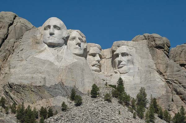
Three of the four presidents on Mount Rushmore started as surveyors — George Washington, Thomas Jefferson and Abraham Lincoln. (Photo: National Park Service)
The role of the surveyor has not been considered political even though several significant U.S. presidents were surveyors in their early careers. Surveyors aren’t particularly known for their public personas, much less their political prowess. Other than states that still have county surveyors, rarely do practitioners stray beyond local municipal government. One is more likely to see a professional engineer or architect as an elected official than a surveyor, but that doesn’t mean the issues we face are any less important.
My current position is a professional land surveyor with a full-time job overseeing a department in a multi-discipline office in a major metropolitan area. Besides being a contributing editor to GPS World through these articles, I also voluntarily wear many hats within our state association and the national surveying society. Several of these hats are government affairs positions at both state and federal levels, as it has become a full-time operation to keep a watchful eye at all governmental levels. From changes in regulations, budgetary revisions and threats to our professionl by outside entities, government affairs take a small army of people to keep abreast of all situations.
This month’s submission is just a snapshot of the current National Society of Professional Surveyors (NSPS) Joint Government Affairs Committee action item list being addressed and monitored through its committee members and a governmental lobbyist. The importance of this list is to give the reader a sampling of the seemingly endless battles being waged on Capitol Hill by NSPS and its members nationwide.
All these issues have GNSS at their heart and will have dire consequences if any of these subjects fall short of their intended marks.
This is not just about the GNSS and how we collect data; it’s also about the necessity of large scale data collection to provide better and safer services to the citizens of the United States and its territories.
Our current datasets and standards for data collection, like our infrastructure, is aging and lacking in detail. Serious upgrades are overdue, so several actions have been put forth to try to rectify the shortcomings.
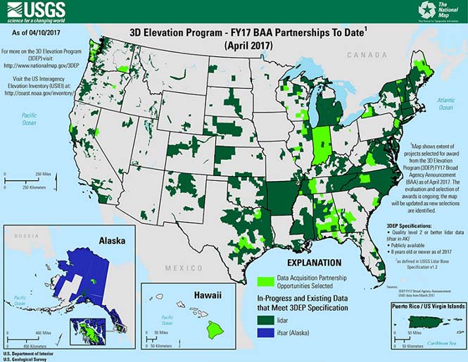
3DEP
Formally known as the 3D Elevation Program, this language was introduced as part of S. 1460 (“Energy and Natural Resources Act of 2017”) by Senator Lisa Murkowski of Alaska. This program is being created so that consistent elevation data, cultivated through many surveying and mapping sources including lidar, will be available for efficient design use throughout the American infrastructure.
While it currently does not have a single line item in any budget, the USGS Budget Summary lists its necessity in the Core Science Systems Program as part of the National Geospatial Program. This program is intended to provide high-quality topographic, geologic and hydrographic data nationwide to assist with further development of energy, transportation, drainage, emergency response and hazard mitigation.
As part of the 2019 President’s Budget, the USGS Green Book also lists having the entire nation covered by an ongoing lidar program by 2033, along with completing a significant amount of data collection by various means in Alaska by 2022, including high-resolution interferometric synthetic aperture radar (IfSAR) necessary for data collection in more difficult terrain.
The Green Book also lists high-resolution hydrographic data to support flood risk management studies, as the frequency of large scale flooding seems to be increasing substantially in more places than ever before. It also includes additional mapping data, programming and functionality for emergency personnel charged with oversight of public safety in times of crisis.
FAA reauthorization
The current FAA authorization bill expires on March 31. The biggest hang up holding up getting the bill reauthorized is privatization of the air traffic controllers, but there are rumors of tightening of UAV rules due to the rapidly growing use of the vehicles for business and personal use.
Surveyors are working with federal and state officials to help implement reasonable rules for use and coverage of the UAV as the field of surveying has been drastically affected by use of aerial vehicles. Many tasks that used to take days now take hours with increase accuracy, so the effects of the UAV will be seen for many years to come.
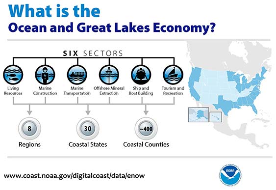
Digital Coast Act
One of the legislative acts that NSPS was a big part of in 2017 was Senate Bill 110, “The Digital Coast Act” which led to the introduction of the companion bill in the House as H.R. 4062. This Act will allow NOAA to perform the necessary actions to actively and effectively monitor all coasts (including the Great Lakes) by various means, including bathymetric and conventional survey methods. This will require services to be performed by public and private surveyors primarily with GNSS capability to provide NOAA with standardized information based upon established datum.
FLAIR Act
The Federal Land Asset Inventory Reform (FLAIR) Act of 2017 was introduced as House Resolution 2199 to help with creating a database of government property nationwide. The Government Accountability Office (GAO) has stated that the management of federal real property has become a “high-risk” item on its list of duties. Management of the number and value of properties has increased to a point that an overall dollar amount of federal buildings and land cannot be accurately determined.
How does the surveyor fit in with this issue? Simple. The U.S. government will need to upgrade its database of existing facilities through having them surveyed for asset management. Part of the requirements for providing these surveys will be completing the work in datums that will be following the geographical databases being designed to contain the parcel and building information. All this data will have geospatial information regarding parcel, address, utilities and functionality of the inventory, so providing the data with the sufficient attributes will become a key role for the surveyor. GNSS data collection will be at the heart of this monumental task.
Geospatial Data Act
As introduced in May 2017, the Geospatial Data Act (GDA) of 2017 is intended to jumpstart the nationwide initiative to develop and coordinate efforts to collect and maintain new datasets of elevation and infrastructure information. It is intended to improve and enhance federal geospatial activities to encourage state and local agencies to participate at the local level.
It is interesting to note, however, that the revised Geospatial Data Act was introduced by the same sponsors that did not include procurement procedures that follow the typical Brooks Act of quality-based selection, and instead relied on bid-based selection commonly found with suppliers. Both bills are being vetted by their sponsors and potential geospatial providers for clarity with ongoing debate going forward.
Hydrographic Services Improvement Act
H.R. 211 bring us the Hydrographic Services Improvement Act to provide NOAA with incentive and funding to standardize surveys desperately needed in waterway areas. Ongoing discussion continues this spring to determine sources of funding and priority of projects.
Infrastructure bill
February brought us the introduction of a significant infrastructure program aimed at improving roads, airports and bridges, with other major improvements across the country. This program is noteworthy in recognizing the need of current geospatial data and inventory of major infrastructure needs. The program sets forth the need for surveying, mapping and geospatial data for planning, design, construction, operations and maintenance for a multitude of projects nationwide. Much more will be discussed regarding the funding and priority of projects as the political year moves on.
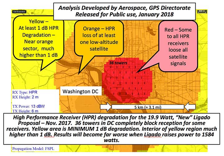
LightSquared/Ligado
Readers may remember when the original confrontation with LightSquared began in 2011, and the subsequent battle over the frequency ranges adjacent to the GPS bandwidth. The FCC gave LightSquared initial but conditional approval to move forward with terrestrial-based transmission for 4G cellular transmission for up to 40,000 land-based stations. Testing by private and governmental agencies through 2011 and 2012 proved that LightSquared would greatly harm GPS activity for both public and private use. Once exposed, the conditional FCC approval was rescinded and LightSquared retreated into the shadows…until now.
Reformed as Ligado, it has fresh investors and is making a charge into 5G technology with a revised game plan. While it is also looking to use other spectrums for communication, it once again is dangerously close to other current uses. Couple the proximity of adjacent bandwidth with the intense land-based signal versus a very weak satellite signal, there will be significant overriding by the new user. All of this is still being worked out through the FCC and the Department of Defense, so final resolution is yet to be seen.
IMAGES Act
The National Flood Insurance Program (NFIP), as part of FEMA, is looking to move forward with legislation introduced as Improvement of Mapping, Addresses, Geography, Elevations and Structures (IMAGES) Act (H.R 4905). This act intends to reform the NFIP program by utilizing new elevation data collected through the 3DEP program, which will be combined with other parcel attributes including addresses and structure types. This data will then be combined with refined floodway information to identify parcels that are more susceptible to damage caused by storms and flooding.
New legislation can be a good thing, but only if funding can be provided. This bill could provide a major upgrade to the flood mapping and insurance program, but it will hit a big snag with lack of monetary support. The proposed funding for FY2019 is $100 million, yet the project costs for the FY2018 budget is $178 million. This significant difference will make a large impact on the effectiveness of the program and proposed revamp.
Railroad reauthorization
NSPS has spent several years working with various legislators trying to find the right bill to insert language to require railroads to monument their routes before removing tracks. But with the recent accidents of various rail lines, the spotlight has been put on various factors that cause the incidents and how to eliminate their occurrence.
Positive train control (PTC) systems incorporate geospatial data collected through GNSS, lidar and conventional surveying means to work with operational systems to assess dangerous situations. Surveyors will need to be at the forefront of the necessary data collection so our efforts to continue lobbying for railroad funding will continue.
Net Neutrality Act
A political hot topic the surveyor doesn’t typically think about is net neutrality. Most people think they will be affected by lack of neutrality slowing down their home internet or streaming service, but for surveyors it will be a much bigger deal.
A remarkable number of surveyors and mappers use cellular data streaming to provide a connection to a positional correction service. The throttling of this data will effectively slow down the performance and quality of the positional data, leading to less reliability and productivity. It will also slow down the data interaction of office and field staff exchanging data and image files critical to project productivity and success.
So, when the call goes out to contact your federal representative to protect net neutrality, remember how it will affect your surveying business model and make that call.
How professional land surveying associations get it done
Many thanks to the countless hours put in by the NSPS Joint Government Affairs team, consisting of Committee Chair Pat Smith, NSPS Government Consultant John Palatiello, NSPS Federal Lobbyist John “JB” Byrd and NSPS Executive Director Curt Sumner. This group is constantly monitoring legislative action across the country as well as in D.C. and is quick to respond when action is needed on legislative issues. They do a tremendous job, yet not many see them in action. Hopefully all surveyors will continue to see and feel the benefits of their results.
As simple as the process is, the political world has gotten much more complicated as time marches on. From local municipal offices to Washington, D.C., getting things done through legislation has become a long process that takes patience and plenty of money to get your voice heard. Surveyors are no different than any other profession in that we must stay out in front of issues that affect our physical and business world. The important part is to stay informed and have a voice.
Let’s also remember those three fine individuals, memorialized on Mount Rushmore, who accomplished great things after their stints as surveyors, so anything is possible if we keep our voice in government.
Surveying has evolved into a highly technical professional with GNSS as a backbone method of data collection. With the U.S. government at the center of that technology, we need to make sure we, as the surveying practitioner, stays engaged.
Joseph Cione, hurricane researcher at NOAA’s Atlantic Oceanographic and Meteorological Laboratory and principal investigator of NOAAs Coyote project, holds the UAV in front of NOAAs P-3 aircraft at MacDill Air Force Base in Tampa, Florida. (Photo: National Oceanic and Atmospheric Administration) (PRNewsfoto/Raytheon Company)
Developed for the military, Coyote is a small, expendable UAV that’s air- or ground-launched into environments too dangerous for manned aircraft. The system can fly for more than an hour and up to 50 miles from its host aircraft.
“Weather forecasters are able to better understand storm behavior and improve hurricane models based on the real-time information provided by our Coyotes,” said Thomas Bussing, Raytheon vice president of Advanced Missile Systems. “Coyote UAVs are collecting and delivering robust storm data that could ultimately save lives.”
In 2017, NOAA researchers deployed six Coyote UAVs to track and model Hurricane Maria. Launched from a NOAA WP-3D Orion hurricane hunter aircraft, the Coyotes flew directly into the storm, giving researchers an unprecedented view of Maria.
Traditional weather instruments are dropped from planes and capture only a snapshot of storm behavior, but Coyote’s winged design allowed it to linger and return to key areas of a hurricane to gather more data and transmit it near-real-time to researchers.
“We think unmanned technologies that explore dangerous and difficult to observe regions of the storm may improve our physical understanding, provide enhanced situational awareness and might ultimately improve the accuracy of hurricane intensity forecasts in the future,” said Joseph Cione, a hurricane researcher at NOAA’s Atlantic Oceanographic and Meteorological Laboratory and principal investigator of NOAA’s Coyote project. “The Coyotes we deployed in Hurricane Maria collected critical, continuous observations in the lower part of the hurricane, an area impossible to reach with manned aircraft.”
The Coyote UAV was first deployed in 2014, when NOAA launched four of the systems into Hurricane Edouard, a Category 3 storm. Scientists on board the aircraft collected meteorological data in both the eye of the storm and the surrounding eye wall.
The northernmost Joint Polar Satellite System Common Ground System station in Svalbard, Norway. (Photo: Raytheon)
Newest version of Raytheon’s Joint Polar Satellite System Common Ground System is now operational
Raytheon’s next-generation Common Ground System for the Joint Polar Satellite System (JPSS CGS 2.0) is now operational, supporting 11 polar-orbiting satellites and delivering observations to NOAA’s National Weather Service almost 50 percent faster than before.
Svalbard, Norway, is the location of the northernmost Joint Polar Satellite System Common Ground System station.
JPSS CGS 2.0 was designed to support the upcoming NASA launch of NOAA’s JPSS-1 satellite on Nov. 14.
“The new ground system significantly improves the mission capabilities of the JPSS program,” said Matt Gilligan, vice president of Raytheon’s Navigation and Environmental Solutions. “It can handle even more data from the full constellation of satellites now and in the future.”
Developed by NASA for NOAA, the JPSS CGS collects and disseminates observations from polar-orbiting weather satellites from the United States, Europe and Japan.
The polar orbiters provide critical weather and environmental data to ensure meteorologists and forecasters have robust, reliable information to make timely and accurate weather predictions that help save lives, protect property and decrease the devastating economic impact caused by severe weather.
Here in the U.S., this past summer saw an unprecedented number of emergency situations. Hurricanes blasted Texas, Florida, the U.S. Virgin Islands and Puerto Rico, leaving people stranded and without power, while wildfires ravaged the west.
So far this year, 15 separate weather and climate disasters have each caused at least $1 billion in damages in the U.S., according to the National Oceanic and Atmospheric Administration (NOAA), meaning, 2017 could tie 2011 for the most billion-dollar disasters. The USA Today chart shows those events.
In Oregon where I live, we experienced unprecendented smoky skies from wildfires — the hazardous air quality affected the health of many.
The silver lining? Growing expertise in the fields of disaster response, mapping, location awareness, UAVs and imagery. We continue to improve our ability to respond to disasters, such as with Waze traffic alerts for wildfire evacuations and UAVs that bring a virtual doctor to a crisis scene along with medicine. We use state-of-the-art technology to learn more about how, why and when disasters happen with tools such as UAVs that penetrate the mysteries of active hurricanes.
Aircraft to Provide Wildfire Measurements in Support of NOAA Fire Weather Forecasting
The U.S. National Oceanic and Atmospheric Administration (NOAA) has selected a small unmanned aircraft system (sUAS) for wildfire measurements and observations in support of its FIREX field mission and the fire weather forecasting initiative.
Black Swift Technologies will deliver to NOAA a tightly integrated system consisting of an airframe, avionics and multiple sensors capable of research-quality measurements of CO2, CO, aerosol, RH, p and T in wildfire plumes, as well as multispectral high-resolution maps of wildfires.
The SuperSwift sUAS will be operated by the University of Colorado’s Integrated Remote & In Situ Sensing Program (IRISS) in close collaboration with NOAA.
“One of the purposes of IRISS is to work with the science community to develop and deploy platforms which make primarily in situ measurements,” said Brian Argrow, IRISS director. “This naturally lead us to partnerships with NOAA on the science perspective, and to Black Swift Technologies for their sUAS technology and expertise. It’s a partnership that looks like a three-legged stool with the science interest of NOAA, the technology and engineering expertise of IRISS, and the unique sUAS platform designed by Black Swift Technologies, as the corresponding legs.”
The FireFOX sUAS is based on Black Swift’s commercially available SuperSwift airframe and SwiftCore Flight Management System — designed to be cost-effective, powerful and easy to operate in the field.
The SuperSwift is specifically engineered to meet the demands of high-altitude flights through strong winds and damaging airborne particulates typical of nomadic scientific field campaigns in harsh environments.
The SuperSwift sUAS has a forward-located, spacious, interchangeable nose-cone payload bay. (Photo: Black Swift)
“While there are many sUAS manufacturers for agencies like NOAA to consider, most are simply not suitable for scientific atmospheric measurements,” said Jack Elston, CEO of Black Swift Technologies.
The SuperSwift addresses NOAA’s requirements for endurance and operational radius (> 2 hours and between 30 to 60 km) sufficient for fire observations, its payload capability (up to 5 pounds), and its unique forward-facing payload bay, “ideal for atmospheric sampling and for easy instrument package swapping,” Elston said.
The ultimate goal of NightFOX is to perform nighttime in situ measurements of wildfire plumes and remote measurements of wildfire properties, with the measurement data used to improve fire weather forecasting.
Because of safety concerns and dangers associated with nighttime operations, manned aircraft flights are limited to daytime operations. Ground observations using a mobile laboratory provide detailed chemical information on fire plumes, but lack information on plume spatial distribution to put the point measurements in context.
UAS observations are the only technology capable of this task. sUAS observations can provide useful information for firefighting efforts by accurately detecting fire perimeter and identifying fire hotspots, but have not attempted to make measurements relevant to studying fire emissions or incorporate observations into fire forecast models.
“Our proposed work, if successful, will significantly advance the integration of UAS-based observations of wildfires into fire-weather modeling and forecasting,” said Ru-Shan Gao, principal investigator, Chemical Sciences Division, Earth Systems Research Laboratory, NOAA.
The collected data will also provide otherwise missing data for studying the impact of North American wildfires on the atmosphere and human health. It will ultimately support better land-management decisions and practices, contributing to NOAA’s core mission to advance understanding and prediction of the Earth system to enhance society’s ability to make effective decisions.
IRISS, a pillar of the CU Boulder Grand Challenge, is a multi-disciplinary team that leads the design, development and deployment of novel remote and in-situ sensing systems to exploit mobility enabled by aerospace systems to enhance data collection from the ground, in the atmosphere and from
space.
With its partners, IRISS explores commercial opportunities and fosters discussions on the ethical, legal, and social policy implications of new technologies and big-data collection.
The existence of a sUAS capable of carrying the necessary instruments routinely through harsh environments adds an invaluable contribution to the calibration and validation of data collected from ground- and satellite-based methods.
The innovations of the SuperSwift, including the total sensor suite, can be used for scientific research by federal and state public agencies and other state-funded laboratories to collect data on coherent atmospheric structures such as smog, volcano plumes, wildfire smoke, chemical fires, forest humidity, and studying oil and gas field flares for calibration/validation of satellite measurements.
“NOAA is interested in a UAS observational system (UASOS) that can use be used for fire-related measurements, and so in a sense what we want to know is when and where does the fire flow and ultimately what kind of fire and air quality will result regionally,” Gao said. “We want to monitor the fire and incorporate the remote and in situ measurements into a fire forecast model so ultimately we’ll be able to do better fire forecasts that will help firefighters better fight the fire and keep human and property losses to a minimum.”
The app provides a new way to measure marine environments on a 3D interactive map for more cost-effective fishery planning and informed conservation.
Esri has released an Ecological Marine Units (EMU) app for mobile devices. The app is a resource for scientists, educators, governments and industries seeking accessible information and imagery about the ocean’s long-term physical and nutrient properties.
The EMU app puts data such as temperature, salinity and dissolved oxygen from 52 million locations throughout the world’s oceans at any user’s fingertips. This data informs how livable marine environments are for ocean-dwelling species as well as the overall health of the ecosystem.
Organizations involved in fishery planning, for instance, can use the EMU mobile app to review proposed boundaries with a better understanding of which habitats will likely harbor certain species and manage fisheries more cost-effectively.
By using the EMU mobile app, industries that depend on fishing yields can spend less time and money on areas that are less profitable. Conservation groups that need easy access to information on the environments of marine protected areas (MPA) to more effectively regulate them now also have a mobile tool for understanding the chemical makeup of these areas.
“The EMU mobile app will serve as a fresh, widely available resource for professionals who benefit from a deeper understanding of the ocean’s structure — its salinity, temperature, oxygen levels and nutrients,” said Dawn Wright, Esri chief scientist. “Scientists and nonscientists alike who must study and understand the ocean now have the freedom of a convenient mobile interface with this vast wealth of environmental data.”
The primary data source for the EMU mobile app is the National Oceanic and Atmospheric Administration’s (NOAA) authoritative World Ocean Atlas, with marine chemistry information from the National Aeronautics and Space Administration (NASA) and topographic data from GRID-Arendal.
The app provides access to this globally comprehensive, data-driven 2D and 3D data and serves as an educational tool for easily understanding marine environments and how they are affected by climate change.
The EMU mobile app is free from the App Store and Google Play.
The U.S. National Oceanic and Atmospheric Administration (NOAA) is seeking new members for its Hydrographic Services Review Panel, a federal advisory committee that advises the NOAA administrator on the agency’s hydrographic programs, products and technology.
“We depend on the perspectives of the people who rely on NOAA maritime products, especially for safety at sea or commercial efficiency, as we plan for improvements of our navigation data, services, and products,” said Russell Callender, Ph.D., assistant NOAA administrator for the National Ocean Service. “This panel is a vital part of our information gathering process to determine future priorities.”
The panel advises NOAA on hydrographic surveying, nautical charts, tides and currents, geodetic and geospatial measurements, and coastal preparedness.
Applicants should have expertise in one or more of the following fields:
marine navigation and technology,
port administration,
marine shipping or other intermodal transportation industries,
cartography and geographic information systems,
geodesy,
physical oceanography,
coastal resource management, including coastal preparedness and emergency response,
other related scientific fields.
Applications must be received by May 30;those received after the deadline will be kept on file and may be used for future panel vacancies. Members serve four-year terms, with meetings occurring at least twice a year.
Hurricane Fran at peak intensity on Sept.4, 1996. (Image: NOAA)
The Washington Post reported March 3 that the Trump administration proposes slashing the budget of the National Oceanic and Atmospheric Administration (NOAA) by 17 percent, cutting steeply into climate change research funding and satellite programs.
The Post cited a four-page budget memo it obtained. In the memo, NOAA’s Office of Oceanic and Atmospheric Research would lose $126 million, or 26 percent, of its funding, while NOAA’s satellite data division would lose $513 million, or 22 percent, of its funding.
The proposed cuts to NOAA would also eliminate funding for f smaller programs, including external research, coastal management, estuary reserves and “coastal resilience,” which seeks to bolster the ability of coastal areas to withstand major storms and rising seas.
NOAA is part of the Commerce Department, which would be hit by an overall 18 percent budget reduction from its current funding level.