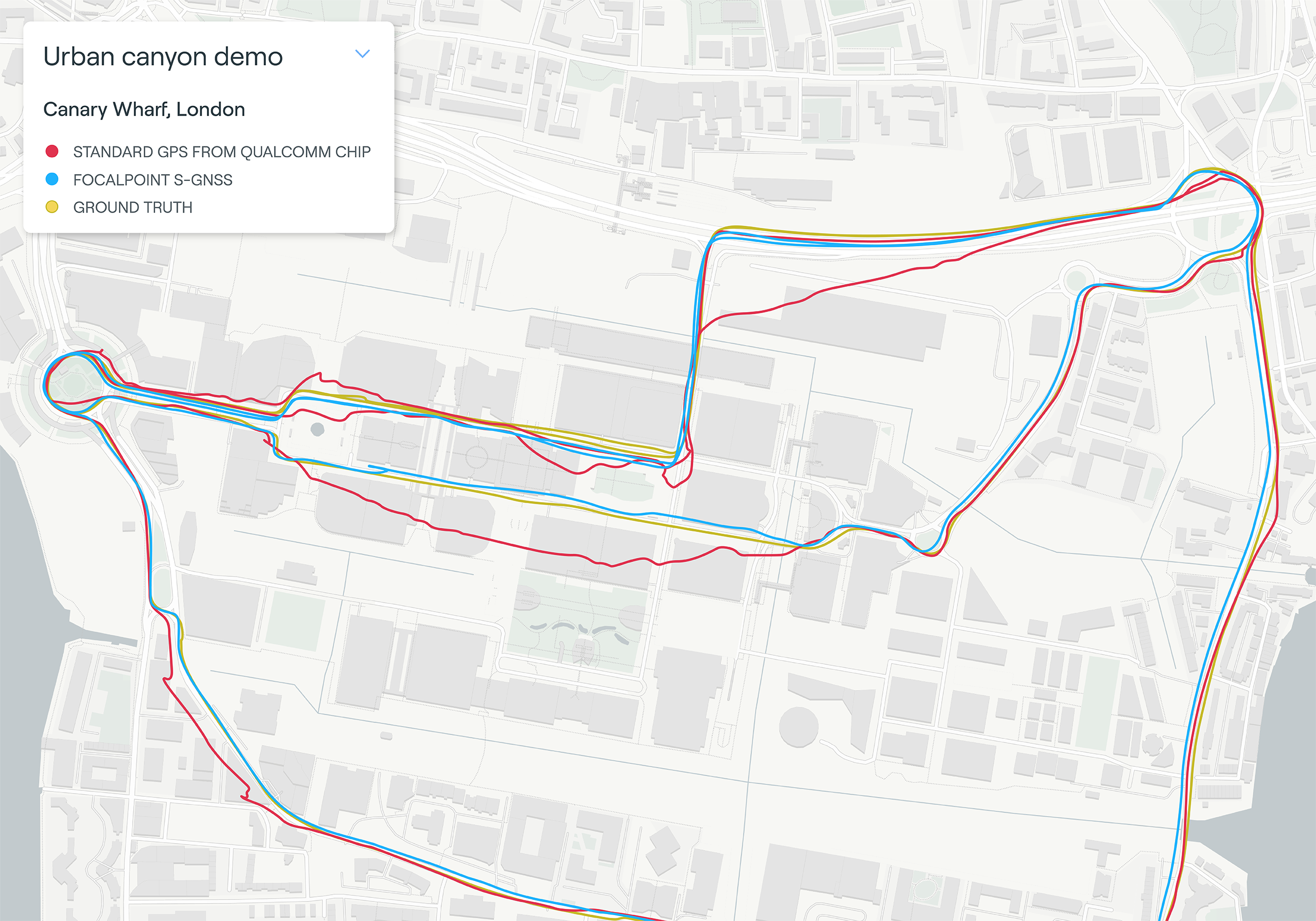
Map plot from live tests in London show the route of a vehicle driven through Canary Wharf. It shows the difference between the position provided by a standard smartphone GNSS chip (red line) and the same data run through Focal Point Positioning’s Supercorrelation software (blue line). (Image: u-blox)
U-blox has signed a deal with the award-winning U.K.-based technology company Focal Point Positioning to integrate technology that will improve the accuracy and reliability of GNSS devices. Focal Point’s Supercorrelation technology enhances positioning performance and security for applications such as smart cities, location-secure internet of things (IoT) and health and fitness wearables.
The patented Supercorrelation technology solves a critical weakness in GNSS caused by multipath interference. Multipath interference occurs when satellite signals bounce off buildings and landmarks, causing GNSS receivers to provide degraded positioning outputs.
The result for users is that the blue dot on their phone or device may be in the wrong place, moving in the wrong direction, or may have a large error ellipse. For autonomous vehicles it could lead to positioning errors that place the vehicle in the wrong lane or worse.
FocalPoint’s Supercorrelation technology uses software to detect and reject reflected signals, resulting in an improvement in the performance of GNSS devices without the need for additional hardware or applications. Supercorrelation also helps with the detection and rejection of GNSS spoofing signals — an increasing concern for autonomous vehicles, ships, and aviation.
“We are tremendously excited to be working alongside a market leader such as u-blox, our mission is to improve every positioning system on the planet and we have taken a giant step forward in that vision with this deal,” said Focal Point Positioning CEO Ramsey Faragher. “Positioning systems are so critical to our world, and we look forward to seeing the next generation of products and services that will be enabled by this higher level of accuracy, reliability and security.”
u-blox CEO Thomas Seiler commented, “The addition of Supercorrelation technology into our latest GNSS platforms is part of our continuing focus on low power consumption, higher accuracy and security for automotive, industrial, and wearable GNSS applications.”
Drivers will now be able to enter what3words addresses directly into their in-car systems, allowing them to navigate to any destination
Image: HERE
HERE and what3words have partnered up to offer the next generation of precision in-car navigation. OEMs using HERE Technologies can now include what3words as an in-car navigation feature, with drivers of enabled vehicles able to navigate to any precise 3-meter square using a what3words address.
HERE is the world’s leading navigation platform with its map data services found in 150 million vehicles worldwide. The platform offers products designed to use the latest location content, such as road networks, buildings and traffic systems. The addition of what3words address entry means that drivers can experience the smartest mapping systems, alongside the break-through address system.
what3words is an innovative addressing system which has divided the world into a grid of 3-meter squares and given each square a unique combination of three words: a what3words address. For example, HERE’s Chicago office can be found at ///memory.traps.lease. what3words enables people to easily convey locations as specific as building entrances or parking spots and it provides easy location references in places with no street addresses, such as beaches, parks and remote hiking trails.
Drivers can input a what3words address directly into their car head unit or connected car app, just as they would a street address or point of interest. Millions of what3words addresses are being used over the world, with drivers finding them in booking confirmations, guidebooks, website contact pages or in messages sent by friends.
Drivers can also discover what3words addresses on the free what3words app or the online map. what3words’ technology has been adopted by global car companies, logistics providers and mobility apps, including Mercedes-Benz, Tata Motors, DB Schenker, Hermes and Cabify.
“HERE is the richest, most accurate and freshest mapping system on the market and it now comes with the easiest way to communicate a location,” Chris Sheldrick, CEO and co-founder of what3words said. “Using a traditional address in a vehicle can be a bad experience. They are clunky and lengthy to type, and even a voice assistant will often mishear you. Once the address is accepted, it won’t take you to a precise location, such as the specific entrance you need, it’ll route you to where the pin drops — which is often the centre of the building.
By using what3words, drivers need simply to enter three words and know they will arrive at that precise 3-metre square. We are seeing increasing demand from automakers and mobility services. Now that we are embedded in HERE, we can enable our address system simply and easily in both new and legacy vehicles.”
“Our partnership with what3words is a solid example of how HERE continues to innovate in the area of navigation,” said Jørgen Behrens, senior vice president and chief product officer at HERE Technologies. “Automotive OEMs and Tier 1 suppliers can now provide the what3words service to their customers with the help of HERE Professional Services instead of having to integrate it themselves. This will allow drivers to navigate easily in dense, urban environments with non-standard addressing schemes or seamlessly get to any location, be it a local pub or a trailhead.”
Incorporating this new feature is easily done for both new and existing clients, with what3words available as an add-on to HERE’s core navigation products.
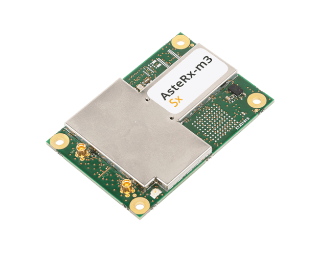
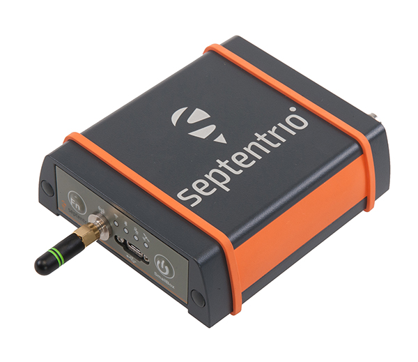
OEM receiver board includes Septentrio’s innovative SECORX-S service, bringing always-on sub-decimeter accuracy, without the need for additional correction subscriptions
Photo: Septentrio
Septentrio has launched the AsteRx-m3 Sx OEM board, a new dual-antenna receiver that combines Septentrio’s latest core GNSS technology with the SECORX-S sub-decimeter correction service to enable convenient plug-and-play positioning.
High-accuracy positioning is available directly out of the box as GNSS corrections are automatically streamed to the receiver. This significantly simplifies the user’s GNSS receiver set-up process and eliminates completely the hassle of corrections service subscription and maintenance.
Corrections are delivered via internet or via L-band satellites ensuring sub-decimeter service even in remote locations where there is no easy internet access.
“With the AsteRx-m3 Sx, we combine our latest GNSS innovations of the AsteRx-m3 family with the convenience of the SECORX-S always-on corrections, all in the same product,” said Danilo Sabbatini, product manager at Septentrio. “This offers higher reliability and operational efficiency to our customers, at an even lower cost.”
With its dual-antenna configuration, AsteRx-m3 Sx offers heading information immediately from power-up, allowing path optimization and fully informed navigation from mission start. Septentrio’s renowned GNSS+ algorithm suite ensures robust and reliable operation in challenging environments even in the presence of RF interference and under heavy vibrations, the company said.
AsteRx-m3 Sx offers PPP-RTK sub-decimeter accuracy with fast convergence time in the U.S. and Europe.
Emcore achieved success in an ultra-high-altitude flight simulation conducted by CAST Navigation, which tested Emcore’s SDN500 inertial navigation system (INS).
Emcore is a provider of advanced mixed-signal products that serve the aerospace & defense and broadband communications markets.CAST Navigation builds simulators for testing and validating GNSS/INS performance in high-end navigation systems.
CAST used Emcore’s SDN500 inertial navigation system (INS) for the test, which required simulating performance at an altitude more than 24,000 meters and velocities over 600 m/s. Only a few aircraft in the world have such capabilities, including the SR-71 Blackbird, but it is not practical to participate in a test flight on the SR-71. Simulating the SDN500 INS test flight to specific customer profiles on a CAST system is straightforward and cost-effective.
Testing began with a stationary period on the ground while the SDN500 initialized and transitioned into air-navigation mode. Then the flight trajectory entered a series of maneuvers, speed and altitude changes that provided observability for various parameters with corresponding changes in the calculated figures.
Emcore relies on GNSS/INS simulators for hardware-in-the-loop testing to verify the expected performance of algorithms. Emcore CORE sought to validate the velocity and altitude limits of a new GNSS receiver along with the algorithm performance in a tactical-grade SDN500 system. In the final analysis, the GNSS receiver and navigation algorithm was confirmed to operate as expected throughout the operation for all three of the customer’s dynamic constraint scenarios.
“We were extremely pleased to demonstrate how Emcore takes advantage of the functionality contained in the CAST simulator to prove-out our robust product performance in customer environments,” said David Hoyh, director of sales and marketing for navigation products, Emcore..
“During the times when there was no valid solution from the GNSS receiver, the algorithm maintained an accurate solution using only the data from the IMU,” explained Andy Williams, senior field application engineer at Emcore who spearheaded the effort. “In addition, there was no algorithm instability or discontinuity when the GNSS receiver resumed, providing a solution to the algorithm. Throughout this entire profile, even when GNSS signal is lost, the SDN500 maintains an accurate navigation solution. This test is not possible without the synchronized GNSS radio frequency and trajectory matching IMU data provided by the CAST system.”
Source: “A True Reference. Theory Meets Reality in Synchronized Simulation Environments,” Inside GNSS, Volume 15/Number 5, September/October 2020, Pages 28, 29, 30.
New service provides PPP convergence for centimeter-level accuracy on land, air and marine applications around the world
Research from Hexagon’s Autonomy & Positioning division has resulted in breakthrough innovations in precise point positioning (PPP) that enable nearly instant global centimeter-level accuracy. These developments pave the way to bring “RTK from the Sky” performance to worldwide users through correction service products and GNSS receivers from Hexagon.
RTK from the Sky technology provides the quick accuracy of an RTK solution with the high accessibility and availability of PPP. Users will no longer have geographic or regional infrastructure restrictions — they will be free to operate anywhere around the world with the same premium level of positioning performance.
RTK from the Sky technology removes the traditional PPP barrier of long convergence times as well as internet and radio communication limitations, delivering instantaneous convergence anywhere in the world. This breakthrough establishes the foundation for assured positioning with no downtime in marine, agriculture, and autonomous applications.
To achieve these results, there must be masterful attention to detail throughout the entire positioning ecosystem: no errors conveniently cancelled and no errors ignored. All errors are carefully estimated and removed from the final GNSS position faster and more reliably than ever before.
This end-to-end fine-tuning of measurement quality and error mitigation establishes the foundation for RTK from the Sky performance. No matter the location or application, users will be able to rely upon the highest availability and accuracy of corrections anywhere in the world, without the convergence time, Hexagon said.
“In 2020, PPP has become RTK — without the mobility limitations,” said Sandy Kennedy, VP of Innovation at Hexagon’s Autonomy & Positioning division. “RTK from the Sky has been a very satisfying development. To see this kind of positioning performance available anywhere in the world is the realization of the next step of innovation for GNSS.”
RTK from the Sky technology will be the foundation for future correction service products and applications from Hexagon built for diverse applications.
Just a couple of pieces of drone news this month — who would imagine flying a fixed-wing drone into the plume of a volcano? And some new advances in tethered drone capability.
Global warming/climate change — a collection of words which can sometimes lead to disputes, disagreements and dismay. These words can fill people with enthusiasm for change and in others have them just shaking heads. I saw a video some time ago made by an eminent scientist who claimed that all the efforts made by humans to pollute over the centuries and the efforts being made now to help the atmosphere, were insignificant when all the junk kicked out on a daily basis by volcanoes around the world was taken into account.
Nevertheless, it’s for sure that the climate is changing — by human hand or by nature — some people are still seeking a scientific basis to establish if it can somehow be remedied — a greener approach which could stop or limit our ability to go on polluting the only world we have, or at least some version of curbing what we are doing to make things worse.
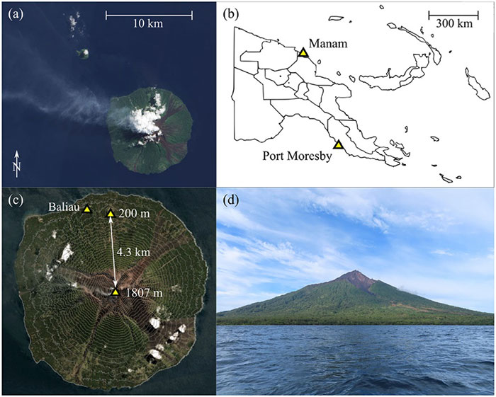
So it was exciting for me to see recent reports of an expedition from last year in Papua New Guinea where an international group used drones in an attempt to measure carbon dioxide, sulfur dioxide and hydrogen sulfide coming out of the active Manam volcano. The objective appeared to be direct sampling of the volcano plume to determine content, not just for measurement alone but perhaps also eventually maybe monitoring changes in gas content to forecast future eruptions.
A series of significant eruptions last took place 2004-2006, and again in 2014, but since then Manam has continued to be explosively active all the way up to the present day. It’s possible to climb almost 6,000 feet to the upper dome, but for more efficient regular monitoring the expedition wanted to demonstrate that a fixed wing drone, operated from a village 2.7 miles away, almost at sea level, would work better. Satellite data on emissions is also available, but apparently no predictions of CO2 content has so far been possible, so land based survey and direct sampling might greatly improve understanding.
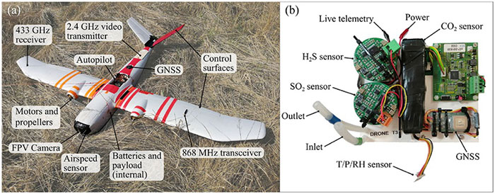
Hand launched, with an internal parachute system for recovery, the Titan UAV, which can lift a payload of around 2 pounds to an altitude of 7,500 feet and has a range of more than six miles. For the trip to the volcano, two 4k cameras provided forward and rear views, oversized electric motors were installed to provide more thrust and onboard data capture allowed for subsequent analysis of the vehicle dynamics as well as the gas content of the environment. Live data was also transmitted real-time to the operator and monitoring crew and was also stored for later review. The autopilot on the drone is capable of automatic GPS waypoint navigation and manual flight mode may be engaged by the operator. The drone carries GNSS, barometric altitude, airspeed indication and IMU sensors.
The automatically flown flight path up 5,300 feet to one of the two volcanic outlets on the mountain followed a zig-zag path to a point offset from the smoking caldera, and if the drone failed to then turn and intercept the plume automatically, it was manually maneuvered in level flight into the smoke column. Plume intercept was interpreted as a steep increase in sulphur dioxide concentration, and at the same time there were increases forces on the drone, at times up to 2.5 g, with roll deviations up to 25 degrees and significant uplift. Not unsurprising rock and roll given the energy being released by the volcano.
After each plume intercept the drone then left the area and descended in a spiral to the launch site, being recovered by manual parachute release. Two flights were successful, yielding lots of data for analysis, but there was an upset while in the plume on the third flight and the vehicle was lost, thought to be related to pulsating increases in the velocity of gas released by magma in the crater and what looked like a 7-g increase in forces on the vehicle. The plume was figured to be between 1800 ft and 2,500 feet wide, using the length of time spent in the smoke column and the speed being flown.
The flights were all conducted under Beyond Visual Line of Sight (BVLOS) conditions as agreed by the local air control agency and significant drone design improvements and flight techniques for subsequent ‘volcano operations’ were recommended. Gas emissions were measured at 3,450 to 4,360 tons/day CO2 and 4,840 to 5,880 tons/day SO2 — so lots of carbon pollution from one of the earth’s most active volcanos, one of around 500 worldwide.
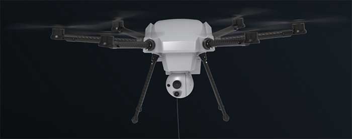
Tethered drones offer advantages for some specific applications such as longer flight times for surveillance. Recent outings by Elistair tethered drone systems have included crowd monitoring and TV coverage for Super Bowl in Atlanta, Ryder Cup golf near Paris France, traffic monitoring in Lyon France, TV coverage for the Alpine World Ski Championships in Sweden, Paris Le Bourget airport approach light monitoring, Trinidad carnival crowd monitoring, Kentucky festival crowd monitoring and communications relay, fire control exercises in Greece, New Year’s crowd monitoring in Vienna and crowd monitoring at Madrid’s soccer stadium.
The Orion 2 tethered drone (Photo: Elistair)
But endurance is a key element for longer term surveillance, so Elistair has come out with Orion 2 which has extended the previous 8-12 hours operations envelop all the way out to 24 hours — and added IP54 dust and water rating, so weather shouldn’t interrupt service.
The tether now extends up to 330 feet so the drone can see out further and it can now also lift a 4.5-pound payload such as a combined ISR (intelligence, surveillance and reconnaissance) and telecom platform. While streaming georeferenced electro-optical and infrared video, 4G/5G communications nodes may also be brought online at the same time.
So an insight into what it takes to fly a drone into active volcano emissions to move us further towards understanding climate change, and improvements in tethered drone endurance. Doubt many of would expect a drone to survive the extreme turbulence created by the energy released from a volcano, or would even try to do so, but one group has been successful and found a new way to monitor activity and measure bad stuff being pumped into the atmosphere. And if we can hover a multi-rotor drone in the air for 24 hours at about 300 feet, who knows what new applications will soon come out of it.
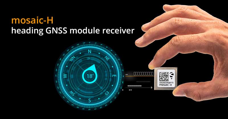
Septentrio has expanded its GNSS module portfolio with the launch of its mosaic-H heading receiver. According to the company, with dual-antenna capabilities, this surface mount module delivers reliable heading and pitch or heading and roll information on top of centimeter-level positioning.
mosaic-H is the new addition to Septentrio’s existing mosaic module family, which already includes RTK and timing modules, as well as modules with integrated GNSS corrections. According to Septentrio, having a single standard footprint across multiple specialized receiver modules enables integrators to create multiple application-specific products based on a single design.
“The mosaic GNSS receivers have set a new performance standard among high-precision GNSS modules,” said Francois Freulon, head of product management at Septentrio. “Adding a second antenna input into the single form factor of mosaic demonstrates Septentrio’s leading position in the high-precision module market. Thanks to its ultra-small dimensions and low power consumption, mosaic-H is the ideal navigation and control solution for robotics, UAVs and autonomous applications which require ultra-robust and secure positioning and heading.”
mosaic-H delivers orientation angles immediately from the start, helping initialize inertial systems which otherwise would require movement before they can measure 3D orientation. INS initialization with GNSS attitude from power-up allows machine trajectory path optimization and fully informed navigation of robotic systems immediately from mission start, Septentrio added.
“In some specific cases, e.g., for critical infrastructures and applications requiring both continuous availability and fail-safe operations, GNSS cannot be the sole means of positioning and timing information.” European Radionavigation Plan, 2018
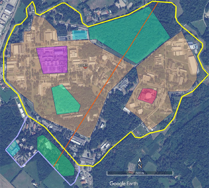
The Joint Research Center in Ispra, Italy, is the preferred demonstration site. (Photo: European Commission)
The European Commission is undertaking a GNSS backup technology demonstration, much like the one completed by the U.S. Department of Transportation earlier this year. Companies from many countries outside the European Union, including the United States, are eligible to participate. Responses are due by Jan. 13, 2021.
A tender issued on Oct. 26 says that the goal is for the commission to better understand available non-GNSS PNT technologies. Also, they are interested in services that can provide positioning and navigation, and/or time.
Completely Independent from GNSS
Since the intent is to provide a backup for GNSS during an outage, all offered technologies must be completely independent. Specifically, they must have “no common points of failure with GNSS.”
Some industry observers have opined that this eliminates any space-based capabilities from consideration. Coronal mass ejections from the sun have long been considered a threat to satellites. Others have wondered if networked-based solutions could be also excluded because of frequent use of GNSS for synchronization, billing and other applications.
Another requirement is that offered technologies be capable of covering the entire EU territory, including inland waters. While this might seem to rule out fiber-based timing systems, advocates say that is not necessarily the case. They contend a fiber network supporting dispersed transmitters would serve both fixed and mobile applications, and reach users for whom connecting to a fiber node is not feasible.
Other requirements listed in the tender for offered technologies include:
Resilience to GNSS jamming, spoofing, and unintentional interference
Technical readiness levels of 5 or more for positioning and navigation, 6 or more for timing
Able to perform for at least a day during a loss of GNSS
Positioning accuracy < 100 m horizontal, or timing accuracy < 1 microsecond relative to UTC
If timing is included, it must be traceable to UTC
The Demonstration
A webinar for potential offerors was held on Nov. 4. Although it was not recorded, the slides shown are available at the RNT Foundation website. One update to the slides is a new email replacing the one of the first slide. All inquiries should be sent to the project leader at [email protected].
Up to seven companies, presumably each demonstrating different technologies, will be accepted into the program.
The preferred demonstration site is the European Commission’s Joint Research Center in Ispra, Italy. Recognizing that transporting equipment and traveling to Italy might be a challenge for many companies, the tender states’ commission personnel are willing to travel to other locations to see systems demonstrated.
The JRC Ispra campus covers 170 hectares with 100 buildings and 36 km of roads. It provides state-of-the-art laboratories, smart city infrastructure (grids, homes, mobility), and varied topography with urban, semi-urban, rural and woodland areas. (Image: EC)
Information on All Technologies Sought
Unlike the European Space Agency’s Navigation Innovation and Support Programme (NAVISP), companies from outside of the EU are invited to respond to the tender and could be selected. This reflects the commission’s desire to include as many technologies and collect as much information as possible.
Limited funding for the demonstration, pandemic travel restrictions, the need for infrastructure to support wide-area signals, and other obstacles may prevent some companies from participating in this effort. The commission’s overall goal, though, is to get information about as many technology options as possible.
So, while not stated in the tender, the commission is eager to hear from technology companies, even if they do not want to be considered as a part of demonstration project. All are invited to contact project leader Ignacio Alcantrailla-Medina. All information is welcome, though most important are a technology’s performance, technical readiness level (TRL), and if it can be deployed in the European Union.
We understand that, as is the case in the United States, solutions delivering timing are of particular interest.
Combining the data from the demonstration project with other information gathered, the commission hopes to be able to identify a way forward with alternative PNT in Europe by the end of 2021.
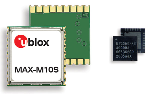
M10 receiver platform can track four GNSS constellations, even in challenging environments
Photo: u-blox
U-blox’s new M10 GNSS platform is designed for ultra-low-power high-performance positioning applications such as sport watches and asset trackers.
The M10 positioning platform can track up to four GNSS constellations at once to deliver positioning data even in challenging environments such as deep urban canyons. The receiver’s Super-S technology helps distinguish positioning signals from background noise to capture positioning data even when satellite signals are weak.
Its high RF sensitivity also enables it to work well with small antennas, making it suitable for compact product designs. In sport watches, for instance, u-blox M10 guarantees highly dynamic positioning accuracy during a run in cities, woods or under an open sky, while preserving battery life.
Low power consumption. The u-blox M10 is designed to consume 12mW in continuous tracking mode, five times less than the power consumed by previous u-blox meter-level GNSS technology, making it beneficial for battery-powered applications.
U-blox M10’s enhanced RF sensitivity also cuts the time it takes for the platform to achieve a first position fix when initialized, further reducing systemic power consumption. And switching to the improved Super-E mode can extend battery life even more.
This new GNSS platform will be supported by AssistNow, u-blox’s assisted GNSS service, to accelerate positioning and improve accuracy. Depending on the required level of assistance, the service is available free of charge or for a recurring fee.
Jamming detection. The u-blox M10 platform benefits from u-blox’s experience in building robust GNSS receivers, incorporating proven techniques for detecting spoofed signals through the analysis of raw GNSS data, jamming-detection strategies, and embedded filters to mitigate the effects of in-band RF interference.
“U-blox can be proud of over 20 years of experience with GNSS technology, and with u-blox M10 we are setting a new benchmark in ultra-low power high performance positioning applications,” said Bernd Heidtmann, product manager, Product Center Positioning, u-blox. “We have increased concurrent reception of satellite signals by a GNSS platform from three to four constellations and improved the power consumption level five-fold compared to previous generations while shrinking the chip size by 35 percent.”
A roundup of recent products in the GNSS and inertial positioning industry from the November 2020 issue of GPS World magazine.
OEM
GNSS receiver
Sub-decimeter accuracy without additional service subscription
The AsteRs-m2-Sx. (Photo: Septentrio)
The SECORX-S product line, which first offered GNSS OEM boards, now also includes a compact mosaic-Sx module and ruggedized receiver in an IP68 chassis, the AsteRx SB Sx. The multi-constellation multi-frequency SECORX-S receivers deliver sub-decimeter positioning without the need for additional correction service subscription or maintenance. The PPP-RTK correction service is integrated directly into Septentrio’s core GNSS technology. The addition of modules and boxed receivers to the SECORX-S line providesz accurate positioning to applications such as precision agriculture, UAVs, robotics and construction.
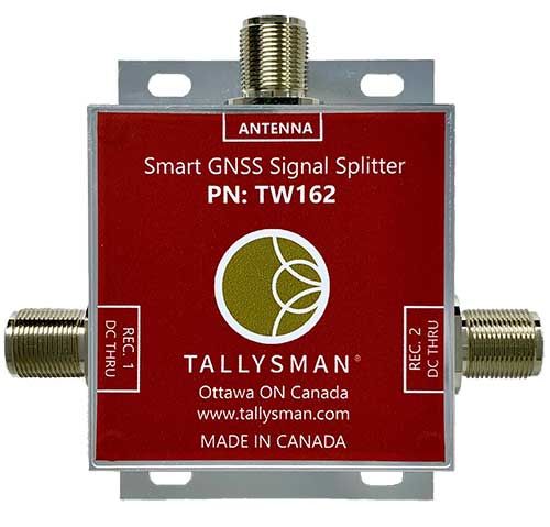
Smart Power GNSS signal splitters improve GNSS service reliability and minimize service interruptions. The professional-grade splitters — TW162 (one antenna/two receivers) and TW164 (one antenna/four receivers) — offer system redundancy and fail-over capability. The splitters are designed to improve GNSS service reliability and reduce signal reception failures. Both splitters offer system redundancy and fail-over capability. They support GPS/QZSS-L1/L2/L5, QZSS-L6, GLONASS-G1/G2/G3, Galileo-E1/E5a/E5b/E6, BeiDou-B1/B2/B2a/B3 and L-band correction services.
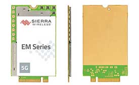
The EM919x 5G NR Sub-6 GHz and mmWave embedded modules include an integrated GNSS receiver. Based on the industry-standard M.2 form factor, the modules will enable original equipment manufacturers (OEMs) to securely deploy 5G connectivity worldwide at the highest possible speeds with ultra-low latency for routers and gateways. The modules support mmWave, sub-6 GHz and LTE, as defined by the 3GPP Release 15 standard. Applications include private networks, enterprise networking, edge processing, live streaming, video security, e-gaming, smart factories, robotics, drones, virtual reality, machine learning, and new Industrial IoT applications.
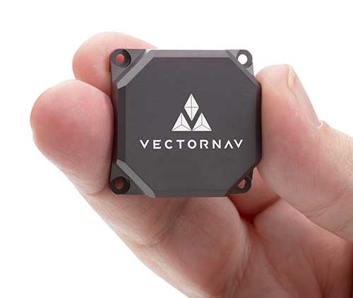
Tactical Embedded series of GNSS/IMUs. (Photo: VectorNav)
The Tactical Embedded series of GNSS/IMUs feature a tactical-grade inertial measurement unit (IMU) and a multi-band GNSS receiver. The line delivers milliradian attitude accuracy and centimeter-level positioning capability in a miniature 15-gram package. The small size enables cost reductions for a range of autonomous pointing and geo-referencing applications such as gimballed intelligence, surveillance and reconnaissance (ISR); satellite communication systems; lidar mapping; and photogrammetry. The line supports external SAASM GPS for defense applications in ISR, electronic warfare, munitions and UAV navigation. The line includes the VN-110E IMU/AHRS, the VN-210E GNSS-aided inertial navigation system (INS), and the VN-310E dual-antenna GNSS/INS.
VectorNav Technologies, vectornav.com
GNSS/INS Sensor
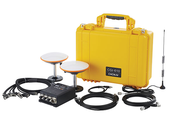
Designed for dynamic environments
Photo: CHCNAV
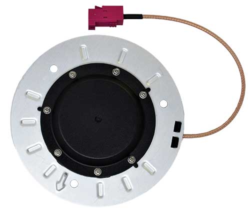
The CGI-610 GNSS/INS high-precision dual-antenna receiver offers reliable and accurate navigation and positioning for demanding land, marine and aerial applications. The tight fusion of the latest GNSS technology with an industrial-grade MEMS IMU is powered by CHCNAV’s algorithms to deliver accurate hybrid position, attitude and velocity data, even in complex and obstructed environments where GNSS outages can occur. The CGI-610 supports data output up to 100 Hz to meet the requirements of highly dynamic applications such as airplane, train and automobile. An optional external odometer sensor for ground vehicles can provide an additional measurement of displacement and speed, which is fused with the GNSS/INS navigation solution.
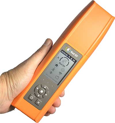
Bad Elf Flex is a scalable-accuracy GNSS receiver with a daily option to choose between L-band and real-time kinematic (RTK). In standard configuration, it achieves 30-60 cm accuracy in real time for GIS use. Consuming a Bad Elf Flex Token unlocks a full RTK workflow for a 24-hour period to deliver 1-cm horizontal accuracy. Bad Elf Flex stores the tokens directly on the receiver, making them available for use anytime. Customers requiring high accuracy at all times can purchase the Bad Elf Flex Extreme bundle, with RTK capabilities permanently unlocked, for a one-time upgrade fee.
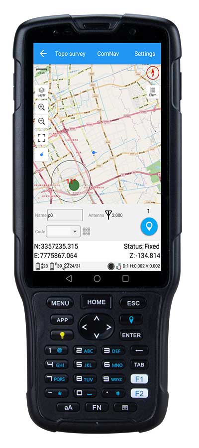
The R550 data collector features an industrial-level design and new hardware platform to ensure efficiency and productivity in the field. The IP67 dust-and-waterproof rating protects the R550 from most harsh environments. Equipping it with a 7,000 mA Li-ion battery allows more than 14 hours of continuous operation, while fast-charging technology means four hours for a full charge. The 5-inch-wide sunlight-readable, high-resolution screen provides a smooth experience for any operation. The integrated autofocusing camera helps enhance job documentation by taking photos on site and sharing job information with colleagues. Survey Master field software available on the R550 controller ensures efficient surveys in the field, including topographic surveys, stakeouts, coordinate geometry (COGO) and more. Powered by the Android 8.1 operating system and designed with 4G RAM, 64GB ROM and 4G/BT/Wi-Fi on board, users can run other third-party apps based on their specific requirements.
The Trimble AP+ Air OEM solution provides direct georeferencing of airborne sensor data and enables users to accurately and efficiently produce maps and 3D models without the use of ground control points. It is designed for manned platforms, yet small enough for use on UAVs. It is also compatible with airborne remote sensors, including photogrammetric cameras, lidar, hyper- and multi-spectral cameras, and synthetic aperture radar. The Trimble AP+ Air features dual embedded survey-grade GNSS chipsets, an onboard inertial measurement unit (IMU), an external IMU, and the new Applanix IN-Fusion+ GNSS-aided inertial firmware. It is configurable to support the direct georeferencing accuracy demands of low-flying UAVs and high-altitude manned platforms. Trimble AP+ Air is supported by Applanix POSPac MMS post-processing software with CenterPoint RTX post-processing for centimeter-level positioning anywhere in the world without the need for base stations.
American-made drone aimed at government agencies and military
Photo: Teal
The Teal Golden Eagle drone is designed for short-range surveillance and reconnaissance missions. It features a FLIR Handron dual-camera sensor on a two-axis stabilizer, giving it color vision at 4K 60 fps and thermal vision for extended operations. The payload is hot-swappable. It has a flight time of up to 50 minutes and can fly at speeds of 50 mph with a range of 2 miles. It is able to fly in wind speeds of up to 30 mph and can operate between –32° and 110° Fahrenheit. Forward-facing obstacle avoidance and rear-facing visual-inertial odometry estimates location without the need for GPS. The platform has received approval from the Department of Defense.
A new line of AccuAuto triple-band antennas are designed to provide strong clean code and phase signals to enable high-precision real-time kinematic (RTK) and precise point positioning (PPP) navigation. Model TWA928 supports GPS/QZSS-L1/L2/L5, GLONASS-G1/G2/G3, Galileo-E1/E5a/E5b, BeiDou-B1/B2/B2a and NavIC-L5 signals and frequency bands (the TWA928L includes support for L-band correction services). The AccuAuto line features patented Accutenna technology multi-constellation and multi-frequency antenna elements as well as an integrated ground plane, a radome and an underside cover that provides mist and condensation protection. A deep pre-filter minimizes out-of-band noise and maximizes in-band reception. All AccuAuto components are certified and designed to perform under challenging environmental conditions, such as extreme temperatures (–40° C to +125° C), shock and vibration.
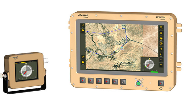
The CheetahNAV provides situational awareness for harsh environments and battlefield conditions, providing the crew of a light military vehicle with highly accurate position information through an advanced inertial measurement system (IMS) comprising several aids, including a gyro-compensated compass and an advanced Kalman-filter-based algorithm. The system provides dead-reckoning horizontal position accuracy of 0.2% of distance traveled in a GNSS-denied situation — accuracy of 200 meters over 100 kilometers. It can integrate with inertial navigation systems (INS). Combined with GNSS and compass information, the system enables dead-reckoning and accurate positioning of the vehicle in tactical situations. The tactical-grade integral inertial measurement unit (IMU) ensures jam-free operation.
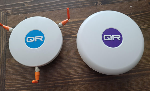
The QR100 and QR201 anti-jamming devices. (Photo: Quantum Reversal)
Quantum Reversal has added several new models to its flagship anti-jamming line. The company introduced in February the QR100 L1/L2 GPS anti-jamming unit and the QR101 L1/L2 GPS anti-jamming antenna.
The current solution consists now of five products designed for the commercial market to solve the issue of unintentional RF interference or jamming:
QR100 – GPS dual frequency L1/L2 anti-jamming unit
QR200 – GPS dual frequency L1/L2 anti-jamming antenna
QR101 – GNSS multi frequency bands anti-jamming unit
QR201 – GNSS multi frequency bands anti-jamming antenna
QR202 – GNSS multi frequency band anti-jamming antenna with additional L-band reception
(1520-1560 MHz)
All models provide robust GPS or GNSS navigation solution, blocking intentional jamming and unintentional RF interference for services such as timing or 3D positioning.
All the products are lightweight (230 grams for QR1xx series and 500 grams for QR2xx series) with low power consumption (1-1.5 Watt typically, depending on the configuration), and can be mounted on any platform (cars, poles, drones, etc.).
Quantum Reversal operates in the information and wireless technology sector, developing innovative wireless and antenna technologies for various commercial markets. The QR team has experience designing products for applications in space, underwater, robotics and unmanned aerial vehicles (UAVs) for the commercial and user end. Each application requires a specific solution to deal with specific environmental (pressure, temperature, vibration, etc.) and operational conditions.
The company sells stand alone products as well as OEM products that can be integrated within the customer products.
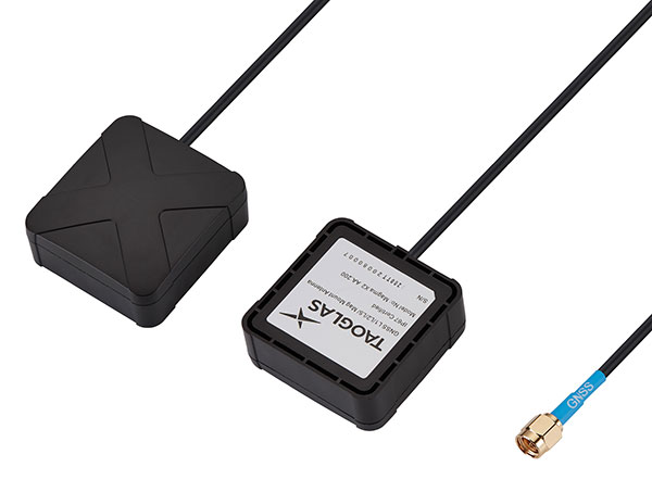
Taoglas has unveiled active, multiband GNSS antennas engineered for applications that require critical high-accuracy positioning and timing, including autonomous driving and precision agriculture. Both the MagmaX2 AA.200 and Colosseum X XAHP.50 add to Taoglas’ high-precision GNSS range.
“Safety standards for autonomous vehicles (UAVs, robotics and vehicles) and precision agriculture is an ever evolving arena,” said Ronan Quinlan, co-CEO and founder of Taoglas. “However, it’s increasingly apparent that high-precision positional accuracy is critical for both. At Taoglas we’re continuously innovating our GNSS antennas to deliver the very best precise location capabilities, but in more lightweight, compact structures, compared to larger counterparts already on the market. We look at the impact the antenna has on the actual positioning performance of your system, not just the antenna itself.”
The MagmaX2 AA.200. (Photo: Taoglas)
The MagmaX2 AA.200 is designed for space and weight constrained applications, such as robotic lawnmowers, Quinlan said. Embedded antenna versions are also available.
The AA.200 is a low-profile active multiband GNSS magnetic mount antenna for use across most major constellations including GPS (L1/L2/L5), GLONASS (G1/G2/G5), Galileo(E1/E5a/E5b) and BeiDou(B1/B2). It exhibits excellent gain and good radiation pattern stability leading to a reliable GPS fix in areas of weaker signal strength.
Positional accuracy better than 60 cm (DRMS) is achievable, even without RTK corrections services. Accurate positioning down to 1.4 cm has been demonstrated with today’s multiband GNSS receivers and RTK services in the field.
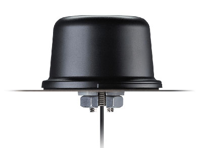
The Colosseum X XAHP.50 antenna. (Photo: Taoglas)
The Colosseum X XAHP.50 is a geodetic-quality small-dome antenna suitable for a vehicle roof mount or pole mount. “Every element and aspect of the antenna performance has been optimized during the design of this antenna,” Quinlan said. “This includes many deep interlocking rf parameters for true accurate centimeter-level positioning, compared to legacy meter-only level systems. Phase center variation, group delay, multipath rejection, axial ratio over angle all become critical considerations and performance targets.”
The XAHP.50 is engineered to operate with incredibly high precision capabilities on the full GNSS spectrum. Sub meter positional accuracy better than 55cm (DRMS) is achievable, even without the use of RTK correctional services. This allows the user to achieve higher location accuracy, as well as stability of position tracking in urban environments.
The XAHP.50 has excellent performance across the full bandwidth of the antenna and its design has an even gain across the hemisphere giving excellent, broad axial ratio which in turn makes it resilient to multipath rejection and excellent phase centre stability. Accurate positioning down to 1.4 cm has been demonstrated with today’s multiband GNSS receivers and RTK services in the field.
Antenna Development
“In the design phase we simulate using electromagnetic analysis software and tweak every parameter,” Quinlan said. “Once we are happy with the results, we build our prototypes and test in scientifically controlled chamber and test environments validated by the European Space Agency, with repeatable GNSS signals.
“We then move onto field testing in open-sky conditions and in non-line of sight environments to verify real-world performance with today’s state-of-the-art receiver systems from such leading companies as u-blox and Septentrio.
What’s more, every single antenna coming off our production line goes through strict in-line sensitivity testing to ensure consistent validated performance. We take our commitment to quality and safety very seriously in the coming age of autonomous operation,” Quinlan concluded.