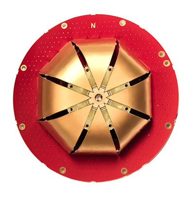
The full GNSS User Technology Report 2020 is available for download. (Cover: GSA)
News from the European GNSS Agency
The European GNSS Agency (GSA) has released its latest GNSS User Technology Report, providing a comprehensive analysis of GNSS trends and developments.
With four GNSS available and more than 100 satellites in operation broadcasting multiple frequencies, the GNSS industry is shifting towards the wide adoption of multifrequency receivers across market segments to meet the diverging user needs of emerging applications.
The report includes contributions from leading GNSS receiver, chipset manufacturers and service providers, and serves as a valuable tool to support planning and decision-making with regards to developing, purchasing and using GNSS technology.
Published biennially since 2016, the User Technology Report has become a point of reference for the GNSS industry, research and policy-makers.
Rapid Evolution
‘’The GNSS industry is evolving at a rapid pace and is shaped by the dynamics of emerging applications and user needs as well as the upgrade of existing and new GNSS and Satellite Based Augmentation Systems (SBAS),” said Rodrigo da Costa, GSA executive director. “The industry has understood the potential of Galileo’s unique features.”
The third edition of the report begins with a chapter devoted to technology trends common to all segments: receiver design, position processing and signal processing. It also discusses protection measures against GNSS jamming and spoofing, such as authentication, including what 5G and other technologies and sensors can do, in combination with GNSS.
With multi-constellation now being the norm, the industry is moving towards the wide adoption of multi-frequency receivers even for usually power- and cost-constrained consumer solutions. The Galileo E5 is becoming the preferred frequency with about 20% of all receiver models in the market already using it.
The report is built around four macro segments defined on the basis of commonalities from a technology point of view:
high volume
safety- and liability-critical
high-accuracy
timing devices and solutions (a new-entry in this edition)
Each chapter starts with the macrosegment characteristics and receiver capabilities, depicts the industry landscape and typical receiver form factor, it then delves into the key current and future drivers and trends, and finishes with the added value of the EGNSS, Galileo and EGNOS, for the macrosegment at stake.
Space Data for Europe
This year editor’s special “Space Data for Europe” sheds light on the role that Copernicus and Galileo play within the European Space Programme in the data management and use, now and in the future. It also provides a vision of major transformations underway within our society and our economy and the benefits expected from this digital transformation, paving the way towards the European Data Strategy and Green Deal.
“Today, Galileo and EGNOS already provide increased capabilities which are being used across a broad range of applications, and are already igniting the next generation of location-based applications. In the future, new services — the Galileo High Accuracy Service (HAS), Galileo Open Service Navigation Message Authentication (OS-NMA) and Commercial Augmentation Service (CAS) — will raise the accuracy and reliability bar even higher, and dramatically enhance positioning, navigation and timing solutions for businesses and citizens.
By bringing insight and understanding into the evolutions of GNSS technology, we are creating opportunities for innovation,” concluded da Costa.
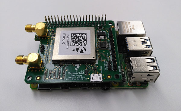
Septentrio, a leader in high-precision GNSS positioning solutions, is offering two open-source resources for its GPS/GNSS module receivers.
The first, ROSaic, is a Robot Operating System (ROS) driver for the mosaic-X5 module as well as other Septentrio GNSS receivers.
The second project, mosaicHAT, is an open source hardware reference design combining mosaic-X5 with a Raspberry Pi single-board computer.
Both projects facilitate integration of centimeter-level reliable positioning into robotic and other machine automation applications.
Photo: Septentrio
ROSaic driver operates on ROS, a widely used programming environment within the industry as well as academics, commonly used for integrating robot technology and developing advanced robotics and autonomous systems. ROS allows data from numerous sensors to be combined allowing high levels of autonomy.
The mosaicHAT project facilitates accurate and reliable GNSS positioning for robotics and automation on a hardware level. Numerous engineers today use Raspberry Pi for prototyping and initial integrations. The mosaicHAT board is an easy way for integrators to get started with Septentrio’s mosaic-X5 GNSS module.
By plugging mosaicHAT into a compatible Raspberry Pi, users have access to high-accuracy positioning with a high update rate, ideal for machine navigation and control, the company said. The small 56×65 mm board exposes basic interfaces such as USB, serial and general-purpose communication pins. The reference design, footprint and documentation are available for easy board printing or further customization.
“We are excited about both the ROSaic driver and the mosaicHAT being part of the GitHub community and we highly appreciate the initial authors work as well as the future contributors,” said Gustavo Lopez, market access manager at Septentrio. “Both projects are available as open source, thus empowering the community to easily fit autonomous or robotic systems with highly accurate and reliable GNSS positioning technology.”
A solution for these COVID-19 days, getting to injured people really fast, and potentially even faster first response applications are all new drone applications featured in this month’s UAV summary.
As people welcome back football this fall — although playing in empty stadiums – most people are staying home to watch the game on TV. Even though some sports teams like the MLB Dodgers resorted to cardboard cut-outs of fans, maybe to encourage players, nothing beats having real people stamping and cheering in the stands.
So its not surprising that when the Atlanta Falcons play the Carolina Panthers this month at Atlanta’s Mercedes-Benz Stadium, they are planning on having a limited number of real live fans at the game to cheer on the teams. Even in these pandemic days of social distancing and masks, it would seem that a reduced number of fans might space out well in the huge 71,000 seat capacity stadium.
But the drone angle comes with the clean-up afterwards — 71,000 seats, handrails and partitions take a lot of manual wiping down – so the Atlanta Falcons are bringing on disinfecting drones to do the job, potentially with only 5% of the effort it normally takes.
There are two D1 drones being used in Atlanta supplied by Lucid, each equipped with a 2.5-gallon tank filled with nontoxic disinfecting chemicals. The sanitation solution is distributed by specially designed ‘electrostatic nozzles’ which spray evenly and mist the area as the drone passes over.
Disinfecting drones have been used before in places which include several locations in China, the city of Dubai, and company EagleHawk in New York offers drone sanitizing for stadiums and other large public facilities. If this approach works we’ll probably see it in many more stadiums in an effort to safely bring back the fans.
Not sure how this next item fits into the unmanned category for this month’s article — because its certainly manned. But what the heck, its certainly interesting and worth a whirl.
Jet packs have been around for a while, but the U.K. company Gravity has come up with a configuration that appears to be reliable and works well. They recently pitched their system for search and rescue in the Lake District — a mountainous area in the North West of England which is extremely popular for hiking, walking and climbing. So visitors will sometimes get hurt falling off a ledge or a high path on the side of a mountain, or just tripping while walking and injuring an ankle, leg or knee. The rocky hilltops, mountains and many lakes of the Lake District attract around 15 million visitors each year, so there is plenty of opportunity for injuries.
With five miniature jet engines and carrying around 35 liters of jet fuel, the Gravity system range/endurance isn’t that great, but boy is it quick if you want to run up the side of a mountain to find an injured hiker. So more rapid response rather than search — provided you already know where the person is located.
The system is powered by a double jet-engine held at the end of each arm and a single engine with equivalent thrust housed in the actual backpack. Altogether, over a 1000 horse power, which is apparently enough to pick a person up and keep them suspended at around 10 feet off the ground. Guess you would need quite some strength to hold onto the arm units, supporting one-third of your weight on each arm, but apparently you get some level of stability assistance from a flight control system in the backpack.
A recent demonstration test in the Lake District with the Great North Air Ambulance Service certainly showed off the suit’s capability to go from the foot of a mountain up to near the crest of the hill in no time flat. Then a regular air-rescue helicopter was immediately called in to take the victim to hospital. However, the current system apparently costs somewhere around $400,000, so its doubtful it will show up for anything but special appearances and demos until there has been significant engineering cost reduction.
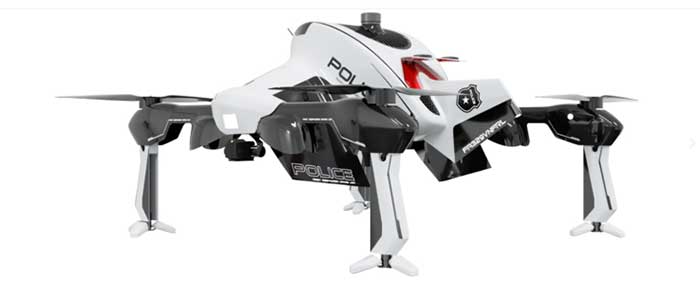
The “Recruit” hi-speed drone is aimed at rapid first response users (Photo: Sonin)
Sonin Hybrid has taken another angle to building a drone by developing a hybrid gas powered propulsion system which charges the vehicle’s batteries while in flight, uses a lightweight carbon-fiber frame with folding landing-legs, and is able to fly at up to 140 mph when pressed to do so. Nominal cruise flight is at 60mph, and flight endurance is claimed to be up to 3 hours – over 5 times that of similar competitor drones.
The Recruit’s options include a stabilized 4k camera, a night vision/IR camera, 30x optical/12x digital zoom camera, a 6k lumen spotlight and a loudspeaker/siren.
With several trials currently underway with first responders, Sonin is eager to establish the requirements for police, fire and military applications. Let’s hope that the trials all involve getting eyes on a location as quickly as possible so hi-speed drone capabilities are needed. Otherwise all the drone racers will probably scoop up these 140mph puppies.
So to enable people to perhaps return to watching sports in person during the ongoing pandemic we have drones pumping disinfecting spray all over sports stadiums which can potentially save huge amounts of manual cleaning effort, provided they can adequately sanitize the target areas — specialized spray nozzles help. Then we have a jet-pack system which was demonstrated getting to injured people as quickly as possible to administer immediate care, followed up by helicopter air rescue. And finally if you want a hi-speed, lightweight drone with good payload capability, Sonin has launched the 140mph Recruit aimed at first responders who need a very quick first response.
These are all completely different applications, all with completely different solutions.
A roundup of recent products in the GNSS and inertial positioning industry from the October 2020 issue of GPS World magazine.
OEM
GNSS antennas
Active and passive
Photo: 2J Antennas
A new range of high-precision GNSS antennas is designed for superior accuracy and reliability, with both active external antennas and passive internal ceramic antennas. The antennas provide precision, high bandwidth, and an advanced signal design for GPS, GLONASS, BeiDou, Galileo, IRNSS and SBAS navigation. They are designed for demanding GPS applications that require centimeter-level accuracy by combining precise point positioning (PPP) of L1 and L2 or by combining L1 and L5 bands with real-time kinematic (RTK) satellite navigation. Applications include aviation safety, UAVs, transportation, autonomous vehicles, agriculture and land and hydrographic surveys.
The HC976 housed and HC976E embedded helical antennas are light and compact, suitable for applications ranging from autonomous navigation to GNSS timing. Both models support GPS/QZSS-L1/L2/L6, GLONASS-G1/G2, Galileo-E1/E6, and BeiDou-B1/B3 frequency bands as well as regional augmentation systems and high-precision L-band correction services. The HC976 and HC976E support QZSS-L6, Galileo-E6 and BeiDou-B3. The HC976 is 44 x 62 millimeters and weighs 42 grams. It features a precision-tuned helical element that provides an excellent axial ratio and operates without the requirement of a ground plane, making it suitable for a wide variety of high-precision applications.
The mosaic-T GPS/GNSS receiver module is built for resilient and precise time and frequency synchronization under challenging conditions. Its multi-frequency, multi-constellation GNSS technology with AIM+ Advanced Interference Mitigation algorithms allows mosaic-T to achieve maximal availability even in the presence of GNSS jamming or spoofing. The compact surface-mount module is designed for automated assembly and high-volume production. Mosaic-T delivers timing and has additional inputs for an external high-accuracy clock.
The HGuide n380 inertial navigation system (INS) communicates an object’s position, orientation and velocity when GNSS signals are unavailable. It is built to withstand harsh environments in the air, on land or at sea. It is designed to meet the need for a small, high-performance INS for 3D mapping, surveying and other applications where space is at a premium. It is composed of Honeywell’s HGuide i300 inertial measurement unit (IMU), a GNSS receiver and Honeywell’s proprietary sensor-fusion software, which is based on the algorithms used for navigation on millions of aircraft every day.
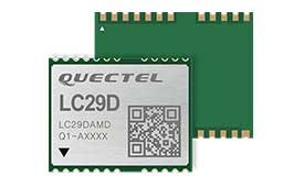
The LC29D eMobility module is a sub-meter-level GNSS module that integrates dead-reckoning and multi-band (L1/L5) real-time kinematic (RTK) algorithm technologies with fast convergence times and reliable performance. The module supports dual-band GNSS raw data output and integrates a 6-axis IMU sensor to deliver high-accuracy positioning performance in seconds. Based on the Broadcom BCM47758 GNSS chip, the LC29D can concurrently receive signals from up to six constellations (GPS, GLONASS, Galileo, IRNSS, BeiDou and QZSS), which maximizes the availability of sub-meter level accuracy. It offers a position update rate of up to 30 Hz (fusion output), enabling dynamic applications like shared emobility, delivery robots and precision agriculture to receive position information with lower latency.
The AlphaUni 300/900/1300 lidar series provides light, versatile long-range laser scanner systems for the high-end market. The series provides optimized data sets powered by advanced GNSS/inertial navigation system (INS) sensors and long-range Riegl scanners. AlphaUni’s design adapts to a variety of applications and can be installed on a variety of platforms, including multi-rotor UAV, fixed-wing vertical-takeoff-and-landing (VTOL) UAV, vehicles, rail trolleys, backpacks, boats and more.
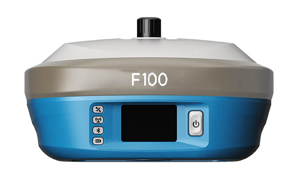
The F100 GNSS receiver, an upgrade to the F90, is designed to meet surveyors’ demands for high field performance, flexibility and cost-effectiveness. It tracks multiple constellations (GPS, GLONASS, Galileo, BeiDou) and can maximize the acquisition and tracking process with all-in-view GNSS frequencies. The 1.45-inch color LCD display is a multi-touch capacitive screen. The F100 has 32GB of internal memory. Its integrated second-generation web user interface control is compatible with all devices and browsers.
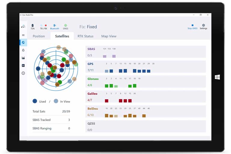
Eos Tools Pro for Windows 10 implements powerful new features that enable users to exploit all four global GNSS constellations and a state-of-the-art NTRIP client to access real-time kinematic (RTK) bases and RTK networks all over the world via NTRIP, Direct IP and wireless radios. It provides the latest support for Windows Geolocation and other features by Microsoft to allow customers to use high-accuracy locations directly in their apps, such as RTK network/RTK base connectivity, support for all new Beidou and Galileo satellites, and SafeRTK functionality for areas with marginal cellular coverage. Features for app developers are also available.
The BB4 UAV high-end multi-rotor drone is optimized for the AlphaUni 300/900/1300 lidar series. Its modular design simplifies deployment in just a few minutes. Its 7-kg payload breaks the capacity barrier, and its more than 45 minutes of flight time increases the airborne lidar survey ability. The redundant CHCNAV and DJI inertial measurement unit (IMU) and GNSS unit provide reliable centimeter real-time kinematic (RTK) positioning, meeting the demand for high accuracy in the geospatial and mapping industries.
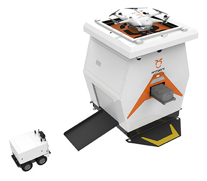
The ADNET autonomous delivery network is a technical solution to transport medical samples and quarantine materials in cities. It uses an RA3 drone, unmanned vehicle RG1 and RH1 hub station to deliver medical supplies without relying on manpower, alleviating time spent in traffic and the cost of traditional delivery. Supplies retrieved by the RG1 vehicle are delivered to the RH1 hub for sorting and redirecting, while the drone transfers the supplies between hubs. The RG1 then delivers goods on the receiving end. The system was demonstrated during China’s COVID-19 epidemic prevention and control period, reducing contact between samples and personnel.
The VECTOR-400 is a compact autopilot designed specifically for unmanned aerial vehicles. It features a robust enclosure and a military-grade connector for harsh environments (MIL-STD 810 and MIL-STD 461). Features enable sea-skimming (extremely low-level flight) and the capability to navigate without GNSS. The VECTOR-400 is able to continue a mission in case of individual sensor failure and when subject to jamming, maintaining accurate estimations of attitude and position. Advanced algorithms provide stall prevention and the ability to carry out an efficient gliding maneuver in case of engine failure. Its air data attitude and heading reference system and inertial navigation system provide high-precision attitude information and reliable navigation under demanding circumstances.
The F700 DroneHunter UAS is a radar-based autonomous interceptor drone for tracking and stopping dangerous drones. Its flexible undercarriage offers interchangeable counter measures for single, multiple or swarm-based threats, while its lightweight carbon-fiber frame enables quick speed and response. The F700 can carry multiple types of anti-drone countermeasures and deploy them in real time, based on which dynamic threat is detected miles beyond the protected area. The pogo pins and payload snaps of the undercarriage are integrated with artificial intelligence for firing and flight software.
Drones equipped with cost-intensive cameras and sensors need protection in the event of a flight-system failure. A parachute system for the DJI M210 drone is now available. Both commercial and emergency response operations are using the M210; its design and flexibility allow for a variety of industry-specific applications. The DRS-M210 parachute system is designed to ensure high pendulum and wind stability, allowing a damaged drone to land safely with minimal impact.
Altitude indicator (AI) or directional gyro (DG) replacement
Photo: uAvionix
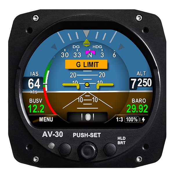
The AV-30-C aircraft panel display adds a suite of in-flight information for pilots, including GPS navigational data, a probeless angle of attack indicator, baro-corrected altitude, indicated/vertical/true airspeed, non-slaved heading, bus voltage and G load. It is designed to fit into any aircraft with a 3 1/8-inch round instrument slot without cutting or modifying the panel. It is authorized for FAR Part 23 Class 1 and Class 2 aircraft listed on the AV-30-C Approved Model List (AML), containing 635 aircraft models including Cessna, Piper, Beechcraft, American Champion, Maule, Boeing, Swift, Mooney, Aviat and others.
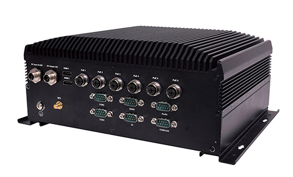
The R3S series of rugged, EN-50155-certified fanless vehicle/rail computers is equipped with a u-blox NEO-M8N module, which receives GPS, Galileo, GLONASS and BeiDou with the default set for GPS + GLONASS dual band. The series offers power-efficient performance for consolidating in-vehicle workloads such as video surveillance, control/monitoring, passenger information and Wi-Fi hotspot sharing. For edge-to-cloud connectivity, R3S uses its internal GPS/GLONASS chipsets for GPS tracking and has two M.2 slots with up to 4x SIM card readers for failover LTE connection. To ensure proper operations in moving vehicles, the series is certified with EN50155, EN50121-3-2, EN50121-4, EN50125-3, EN45545 and E13 standards and has passed MIL-STD-810G shock and vibration resistance certifications. The series can operate under a wide temperature range and offers excellent reliability in harsh railway settings. It has one external removable 2.5-inch HDD/SSD drive bay for recorded footage storage. For consolidating in-vehicle workloads such as in-vehicle control/monitoring and passenger information, the R3S features a variety of I/O support, including 2x HDMI, DI/DO, 3x COM/CAN BUS and 4xUSB ports.
Tallysman Wireless Inc. has added four new embedded VeroStar Mini products to its line of antennas. The ultra-compact and lightweight embedded VeroStar Mini models offer the same key features as the full-size VeroStar models but in a smaller, lighter package, with either a 90-mm (58 g) or 106-mm (69 g) integrated ground plane, both 32.4 mm in height.
The VSM6028, VSM6028L, VSM6328 and VSM6328L embedded VeroStar Mini antennas are designed and crafted for high-accuracy positioning. With an exceptionally low roll-off from zenith to the horizon, VeroStar antennas provide the excellent tracking of GNSS and L-band correction signals at low elevation angles.
The VSM6028 VeroStar antenna. (Photo: Tallysman Wireless)
Also, the optimized axial ratio at all elevation angles results in excellent multipath rejection, enabling accurate and precise code and phase tracking. Additionally, VeroStar antennas feature a robust pre-filter and high-IP3 LNA architecture, minimizing de-sensing from high-level out-of-band signals, including 700 MHz LTE, while still providing a noise figure of only 1.8 dB.
The light and compact wide-band spherical antenna element enables the VeroStar Mini to deliver a ±2 mm phase center variation (PCV), making it suitable for high-precision applications such as autonomous vehicle navigation (land, sea, and air), smart survey devices, and maritime positioning.
The VSM6028 supports the full GNSS spectrum (the VSM6028L includes support for L-band correction services), while the VSM6328 supports the GPS/QZSS-L1/L2/L5, GLONASS-G1/G2/G3, Galileo-E1/E5a/E5b, BeiDou-B1/B2/B2a, and NavIC-L5 signals and frequency bands (the VSM6328L includes support for L-band correction services).
The unique features of the VeroStar Mini antennas guarantee it can deliver a high signal-to-noise ratio (SNR), high accuracy, and high precision in the most challenging environments.
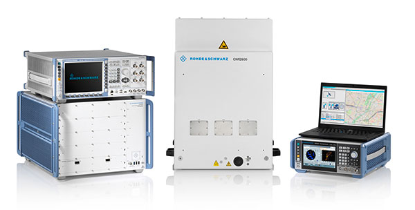
Rohde & Schwarz supports 5G LBS with assisted GPS and 5G NR FR2 mmW performance testing
Photo: Rohde & Schwarz
Simulator and test company Rohde & Schwarz has verified assisted GPS (AGPS) performance in a commercial mobile device, while simultaneously transferring data using 5G millimeter wave (mmW). This capability is now available with the Rohde & Schwarz TS-LBS (location-based services) test system.
As wireless network operators roll out 5G NR in the millimeter wave spectrum, it is critical to ensure continued reliability of E911 calls and accurate determination of location in mobile devices.
5G NR utilizes frequencies in the FR1 frequency range (<7.125GHz) and in the FR2 mmW frequency range (>24GHz). FR2 creates unique challenges for mobile devices in terms of power consumption and heat. With FR2 becoming more common in North American mobile devices, performance of critical services such as E911 emergency calls cannot be allowed to degrade when utilizing this mmW spectrum.
When used together in the TS-LBS test system, the R&S CMX500 radio communication tester and R&S CMW500 wideband radio communication tester provide a seamless and comprehensive test platform capable of testing LTE, 5G NR FR1 and FR2, while the R&S SMBV100B vector signal generator simulates the GPS L1 & L5, GALILEO, GLONASS & BEIDOU satellite constellations for A-GNSS.
Other positioning technologies that use barometric pressure sensors, Wi-Fi and/or Bluetooth are also available in the same solution. Legacy technologies such as GSM, WCDMA and LTE are all supported using the same hardware.
“The addition of FR2 mmW to our TS-LBS test solution gives customers the latest capabilities needed to continue certifying their mobile devices to evolving 5G standards,” said Bryan Helmick, Rohde & Schwarz. “Customers can easily add 5G to existing LTE TS-LBS systems with the simple addition of an R&S CMX500. FR2 support only requires some hardware on the R&S CMX500 and an R&S CMQ500 mmW shield cube.”
5G NR in the sub 6 GHz frequency range (FR1) can be seen as a natural evolution of LTE to achieve higher bandwidth and more flexibility on the physical layer in order to realize all the new and additional use cases defined for a next-generation mobile network.
The real technical challenge, however, comes with 5G mmWave (FR2), which opens up a new level of complexity in device development. mmWave frequencies imply measurement challenges that call for new testing approaches.
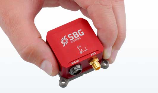
SBG Systems has built a program designed to sponsor student teams participating in competitions, as well as offer discounts for universities and research centers on inertial sensors and post-processing software.
Through the program, the company sponsors students participating in competitions in various fields, such as robotics, autonomous vehicles, UAV, rockets, unmanned and solar boats and more. This includes support during the competition, as well as during the installation of SBG’s latest inertial navigation systems in the teams’ vehicle prototype, the company said.
SBG’s Ellipse series is also eligible through its education program. The series is composed of SBG’s miniature inertial measurement units, attitude and heading reference systems and inertial navigation systems. In addition, the entire product line has been renewed. The new Ellipse INS/GNSS embeds a quad constellation, dual frequency, and dual Antenna RTK GNSS receiver to bring centimetric position and higher accuracy orientation in the smallest package, SBG added.
In addition to being compatible with CAN and ROS, the Ellipse Series’ sensors are compatible with SBG’s Qinertia Post-Processing Software, the SBG Systems’ in-house INS/GNSS post-processing software. Qinertia allows users to replay, analyze, improve their trajectories and access RTK corrections worldwide to bring their project to the centimetric accuracy.
SBG Systems designs and manufactures MEMS-based inertial motion sensing solutions. According to SBG, its products are ideal solutions for industrial and research projects such as unmanned vehicle control, antenna tracking, camera stabilization and surveying applications.
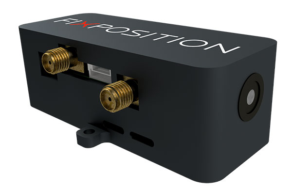
Vision-RTK enables applications in previously unreachable areas and unlocks new possibilities for autonomous ground robots and drones
At this year’s Intergeo Digital event, taking place Oct. 13-15, Fixposition is debuting the Vision-RTK positioning sensor, a compact centimeter-accurate solution with high reliability and availability in environments that are challenging for traditional GNSS.
Photo: FixPosition
The Vision-RTK’s sensor-fusion algorithm is based on the deep integration of satellite, camera and inertial sensors, and enables unprecedented reliability and availability in diverse and challenging applications, the company stated.
“The highly integrated nature of our Vision-RTK sensor and our deep expertise in computer vision and real-time kinematic (RTK) GNSS enabled us to implement completely new approaches in sensor fusion, resulting in previously unseen performance,” said Lukas Meier, CTO and co-founder of Fixposition.
Traditional GNSS sensors suffer from limited reliability in GNSS-challenging and denied areas. On the other hand, standalone computer vision is sensitive to light conditions (such as snow, strong sunlight and rain) and struggles in situations where there is a lack of features such as cornfields and grass. Errors accumulate over time with standalone inertial technology, causing large drifts.
As a result, devices using either sensor are limited in their range of operation and are likely to fail in certain conditions. Fixposition’s solution increases the potential of these sensors with its unique sensor-fusion technology by increasing the trustworthiness of the positioning accuracy and the range of operation in different environments.
The real-time sensor fusion provides centimeter-accurate absolute positioning at any time, in any outdoor environment. This small module integrates two RTK-GNSS receivers and visual inertial navigation, and is suitable for applications where size and accuracy are of paramount importance.
The dual-receiver configuration, together with Fixposition’s advanced algorithms, provides a true-heading output and increased resistance to electromagnetic radiation.
The sensor provides USB and Wi-Fi connectivity and a web interface. It enables straightforward integration in state-of-the-art autopilot control systems for drones and robots. It’s also plug-and-play compatible with platforms such as PX4, ROS and Apollo.
For ground robotics and drones applications, Vision-RTK increases the device uptime and efficiency while enabling new market segments in areas previously inaccessible. For end-device manufacturers, this technology eliminates the need for an in-house development of advanced localization solutions, shortening their sales cycle and reducing costs and investments.
Visit the Fixposition booth and meet the team at Intergeo Digital 2020 to learn more about the Vision-RTK sensor.
The European Space Agency (ESA) has launched a call for proposals to demonstrate the capabilities of new 5G cellular networks to support positioning and timing applications to complement satellite navigation.
5G will bring higher speed, larger traffic capacity and ultra low-latency (or signal delay) communications. 5G will also usher in a range of new possibilities for positioning, navigation and timing (PNT).
ESA is inviting proposals to implement pilot projects to demonstrate the viability of 5G PNT solutions in a number of use cases:
Indoor PNT for Industry 4.0, as needed to support the operations of smart warehouses and factories or smart city applications requiring transition from indoor to outdoor environments.
Outdoor applications where a robust back-up to satellite navigation is essential to meet safety requirements, such as autonomous driving or drone navigation.
Applications where robust time and frequency synchronization is necessary, both in outdoor as well as indoor environments, like smart energy grids or the 5G networks themselves.
5G networks will allow new types of measurements made possible by advanced antennas and by new positioning signals at higher frequencies, at both base stations and the user receivers. 5G networks will also bring enhanced connectivity to improve cloud-based positioning applications and value-added services.
While satellite navigation works optimally in outdoor environments with a wide view of the sky, 5G PNT has the potential to bring PNT to deep urban canyons in high-rise city centers and indoor warehouses, wherever 5G networks are deployed.
The combination of satellite navigation and 5G brings the promise of high performance, secure and resilient PNT services, as well as a seamless application of PNT applications from outdoor to indoor environments and from rural to urban areas, ESA said.
This call for ideas is supported through ESA’s Navigation Innovation and Support Programme (NAVISP), working with European industry and academia to develop innovative navigation technology.
Webinar on PNT 5G
To support the call, an information webinar is being held on 21 October, in which the various PNT 5G use cases will be presented by key speakers from each sector. Details of the call and how to apply will also be presented by ESA.
A networking platform has also been established to allow webinar participants and general stakeholders interested in the call to get in touch and discuss possible cooperation. This platform will be kept open during the entire period of the call’s duration.
For more information on the call and the agenda of the webinar visit ESA’s NAVISP website.
To register for the webinar and the networking platform, click here.
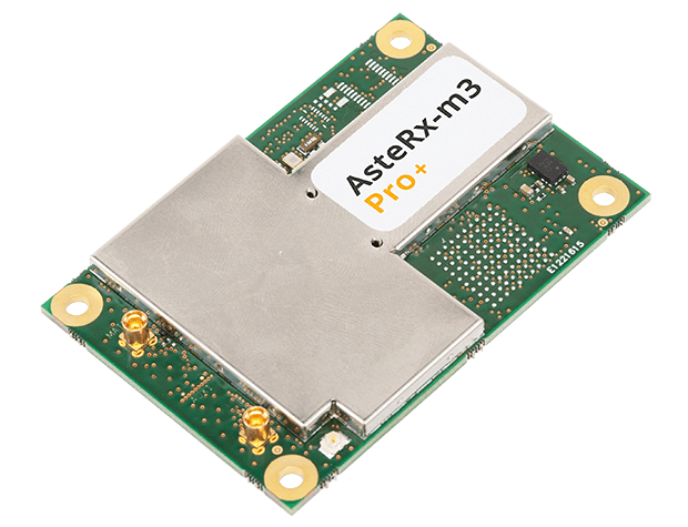
The new AsteRx-m3 family features state-of-the-art GPS/GNSS OEM boards optimized for power consumption and ease of integration.
Photo: Septentrio
Septentrio has expanded its GPS/GNSS OEM portfolio with the AsteRx-m3 product family. AsteRx-m3 receivers target various use cases and offer flexibility and affordability with no compromises of performance.
The AsteRx-m3 family features very low power consumption, allowing longer operation times. Its easy-to-integrate design enables short set-up times and faster time-to-market.
“With the AsteRx-m3 product family, Septentrio redefines state-of-the-art GNSS positioning performance,” said Danilo Sabbatini, product manager at Septentrio. “It was a challenge to design a product that delivers multi-frequency and multi-constellation positioning, combined with Septentrio’s renowned GNSS+ technology while optimizing power. The AsteRx-m3 product not only excels in this but does so at a reduced cost.”
All AsteRx-m3 products represent the next generation of technology in the GNSS OEM market, delivering centimeter-level accuracy, availability and reliability in a credit-card sized board, Septentrio said.
The new product family includes three types of GNSS OEM boards.
The AsteRx-m3 Pro rover receiver tracks signals from all available GNSS constellations on three frequencies. Simple and powerful, it operates both in single- and dual-antenna modes.
The AsteRx-m3 ProBase is designed to operate as a reference station for RTK and PPP-RTK networks. It can be used as a base station or for network densification.
The AsteRx-m3 Pro+, a full-feature OEM receiver board flexible enough to fit into any application and to be used either as a rover or a base station in a single- or dual-antenna mode.
By offering its next-generation GNSS technology in a diversity of products Septentrio aims to improve customer experience while optimizing prices.
YIC is a manufacturing and design company for quartz crystals, crystal oscillators, GPS/GNSS modules, GPS/GNSS receivers and RF antennas. It provides low-power solutions to solve product problems that require frequent charging.
YIC’s new product — the Ultra Low Power GPS/GNSS Module (Model YIC71009EBGG and YIC71513PGMGG) — is designed as an IoT product solution, targeted to improve the operating times of IoT applications such as trackers, wearables and portable devices.
According to its press release, YIC “is dedicated to providing the best solution for GPS devices and sees a tremendous opportunity in the GNSS market to solve power consumption problems.” The recent industry trend of multi-frequency GPS, low-power consumption, and dead reckoning will be advantageous to YIC in terms of high-grade products entering the global market.
Models YIC71009EBGG and YIC71513PGMGG provide:
Ultra-low power consumption – 6mA (Typical).
Multi-constellation – GPS/QZSS + GLONASS.
Small size
About YIC
Founded in 1994 and headquartered in New Taipei City, Taiwan, YIC is a professional partner in frequency control, GPS/GNSS modules, receivers and RF antennas, advanced low power GPS, and small size solutions.
In a special advertiser-sponsored section of our October issue, we spoke with prominent GNSS companies about their current solutions for today’s industry challenges.
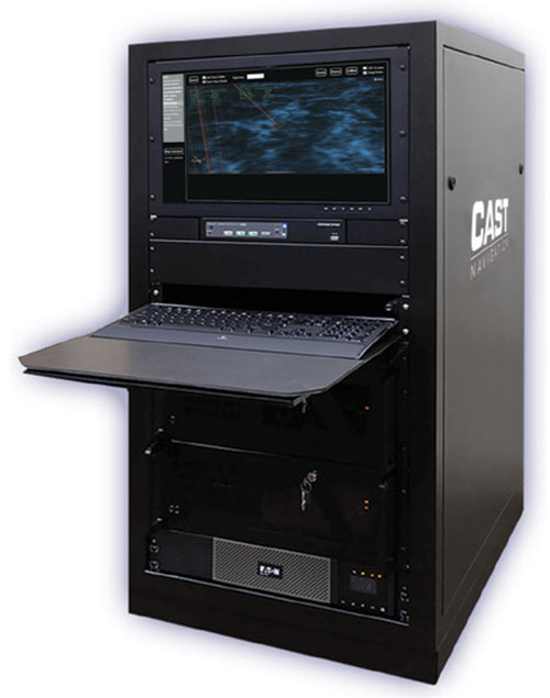
Q&A with CAST Navigation
Answered by Lou Pelosi, vice president
Lou Pelosi, vice president
Q: What is your most proven GNSS solution?
A: CAST Navigation does not supply GNSS receivers (GNSS solutions), rather we manufacturer GNSS simulators which are used to test GNSS receivers. CAST has had the most success with our GNSS/INS simulator. It provides an Embedded GPS Inertial (EGI) navigator with coincident GPS and inertial data. The EGI “thinks” it is moving while it remains stationary.
With our GNSS/INS simulator, the operational flight program of the EGI can be tested. During development of a platform’s navigation system, the CAST simulator is used to recreate the identical test conditions as the EGI’s software is modified. Once the platform’s navigation system is finalized, the output of the EGI is used to drive other systems, such as flight control or radar.
The GNSS/INS simulator can also include Controlled Radiation Pattern Antenna (CRPA) test features. If the EGI being used by the platform has an anti-jam antenna, the simulator can also test that feature.
The CAST GNSS/INS simulator has proven to be a key piece of equipment in system integration laboratories as new aircraft are developed.
Photo: CAST Navigation
Q: What are the solution’s key specs?
A: A key element of our GNSS/INS simulator is the inertial model contained in the simulator. It is a whole value inertial model rather than an error model. In its normal state, it reacts in the same manner as the actual inertial of the EGI. It also had degraded modes that are used to simulate hardware failures. When analyzed by the EGI manufacturers, its noise characteristics are almost identical to fielded navigation systems.
Q: What are the solution’s key features and benefits?
A: The most obvious benefit of using a CAST GNSS/INS simulator is cost savings. Even with the cost of lab equipment and personnel, there is still a savings over flight testing. A key feature of using a simulator for testing is its repeatability. Every time you rerun a test; the conditions are the same. In the real world, the satellites change constantly. Being able to accept real-time trajectory data is another key feature of CAST simulators. Instead of using our internal point mass model for scenario generation, an actual flight profile can be sent to the simulator from an external computer.
CAST has also been authorized by the GPS Directorate to provide classified functions to authorized users. Available options include Y-code, SAASM and M-code MNSA.
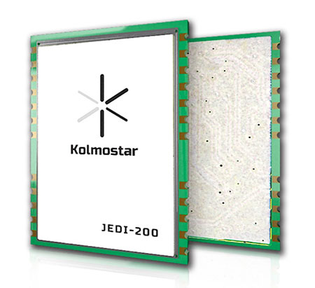
A: Kolmostar specializes in ultra-low-power, instant cold-boot GNSS positioning solutions for internet of things (IoT) applications, mobile devices and beyond.
Q: What are the solution’s key specs?
A: Our advanced GNSS positioning module JEDI-200 is specially designed for location-based IoT applications such as asset tracking, fleet management, pet/livestock tracking, smart wearables and share economy. It is also optimized for integration with LPWAN (low power wide area network) technologies such as LoRaWAN®/NB-IoT/LTE-M to provide the ultimate ultra-low-power profile for IoT applications. There are two outstanding advantages of JEDI-200: ultra-low-power and instant cold-boot. With 25 mW power consumption and the revolutionary 1-second TTFF (time to first fix), JEDI-200 is able to reduce the energy consumption to get one position fix by up to 120x compared to traditional GNSS modules on the market.
Q: What are the solution’s key features and benefits?
Photo: Kolmostar
A: GNSS/GPS sensors are one of the most power-consuming sensors in IoT or mobile devices. Battery life will be significantly shortened when GNSS/GPS sensors are turned on. Hence, many IoT and mobile devices either do not include GNSS/GPS sensors or have to equip themselves with very large batteries, incurring much inconvenience and cost. Kolmostar’s ultra-low-power and instant cold-boot JEDI-200 module is specially designed to solve this long-standing industry pain point.
With its ultra-low-power feature, JEDI-200 is able to reduce the energy consumption to get one position fix by up to 120x when compared to traditional GNSS modules. IoT devices with very limited-sized batteries are now able to have GNSS positioning ability while still maintaining a battery life up to 10+ years. Another key feature of JEDI-200 is instant cold boot. Unlike traditional GNSS modules’ 30-second TTFF in cold boot, JEDI-200 can achieve an instant 1-second TTFF, providing a better and more seamless customer experience when short latency/response time is particularly desired in certain applications. In addition, JEDI-200 is optimized for LPWAN technologies such as LoRaWAN®/NB-IoT/LTE-M, further reducing both the cost and the power consumption of devices’ wireless communication, which is another big challenge most IoT and mobile devices previously faced.
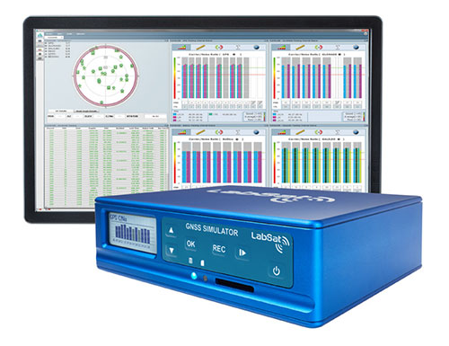
A: The LabSat 3 Wideband GNSS simulator offers multi-constellation and multi-frequency capabilities for reliable, repeatable and consistent testing. Its one-touch Record and Replay provides an efficient way to test and develop GNSS receivers without the cost, inconvenience and limitations of live-sky signals. Combining LabSat with the custom simulation software SatGen enables the creation of GNSS RF I&Q or IF data files based on a bespoke scenario, allowing for almost any kind of test at a set time, date and location.
Q: What are the solution’s key specs?
A: With three channels, a bandwidth of up to 56 MHz and 6-bit sampling (3-bit I and 3-bit Q), LabSat 3 Wideband can handle almost any combination of constellations and signals that exists today, with plenty of spare capacity for future planned signals.
Q: What are the solution’s key features and benefits?
A: LabSat 3 Wideband is small and affordable, making it an ideal solution for companies to provide their employees with a suitable method of testing their GNSS devices whilst working from home. In addition to its compact size, an internal battery delivers up to two hours of run time to record scenarios in even the most challenging field environments.
Photo: Labsat
It is incredibly user friendly with one touch record and replay and an HTML interface that makes setup simple and problem-free. A range of additional signals can also be recorded and synchronized to the GNSS input: dual-CAN, RS232 and digital inputs are simultaneously captured, increasing the level of playback realism and allowing for a wider range of testing.
The latest version of SatGen can be used to create a single scenario containing all the upper and lower L-band signals for GPS, Galileo, GLONASS, BeiDou and NavIC, and takes advantage of the LabSat 3 Wideband’s ability to read RF data at up to 95 MB/s. Creating an artificial scenario using SatGen allows for precise control of the data content, creating a standardized file for repeatable testing and carrying out true comparisons between receivers.
The versatility of the LabSat 3 Wideband makes it a familiar sight on the desks and benches of technology companies around the world. From GNSS device and application testing to receiver sensitivity and end-of-production-line testing, LabSat 3 Wideband is a perfect testing partner.
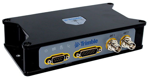
Q: What is Trimble OEM GNSS’ most proven GNSS solution?
A: The Trimble BX992 is the flagship product from the Trimble OEM GNSS portfolio, proven in multiple environments and applications. Powered by the BD992-INS receiver module, this rugged yet compact enclosure allows original equipment manufacturers and system integrators to rapidly integrate precise position and orientation data to guidance, control and autonomous applications. Continuous data sets collected from test sites and real-world applications around the world have been used to create a powerful engine that performs in the most challenging of GNSS environments.
The Trimble BX992. (Photo: Trimble)
Q: What are the solution’s key specs?
A: The Trimble BX992 delivers low-latency 100-Hz centimeter-level positions with tight integration of IMU sensor data and GNSS observations in the RTK/RTX engine. The rugged IP67 enclosure supports multi-frequency tracking from GPS, Galileo, GLONASS, BeiDou, QZSS and NavIC constellations. The dual-antenna inputs allow rapid and robust alignment of onboard gyro sensors. With Trimble RTX correction services, the BX992 delivers reliable, high-accuracy positioning without a local base station or cell modem.
Q: What are the solution’s key features and benefits?
A: The BX992 is a full-featured solution with an onboard spectrum analyzer, a critical tool for developers to identify interference from unwanted signals, thus allowing products to be released to the market within specification and on schedule.