Agreement focuses on increasing development and capacity for ultra-compact, low-power laser-beam scanners to expand the market
STMicroelectronics and OQmented, a startup focused on MEMS-mirror technology, have agreed to collaborate on the advancement of the technology for augmented reality and 3D-sensing markets. Micro-electro-mechanical systems (MEMS) combine tiny 3D mechanical structures and electrical circuits on a chip to sense and actuate activity.
The joint effort aims to build on the expertise of both companies to advance the technology and products behind the leading MEMS-mirror-based laser-beam scanning solutions in the market.
ST manufactures MEMS sensors, actuators and related components including drivers, controllers and laser-diode drivers. ST is contributing its MEMS design and manufacturing resources to the collaboration.
OQmented plans to further industrialize and mass produce its Bubble MEMS technology, a patented 3D glass-encapsulation method of hermetic vacuum sealing of MEMS micro-mirrors. The glass bubbles eliminate environmental contaminants and minimize light-refraction effects.
Automotive grade. Vacuum sealing is a key element for meeting automotive-grade requirements, while simultaneously reducing power consumption by an order of magnitude and enhancing performance for resonant, bi-axial scanners, where the MEMS mirrors move in both axes at their resonant frequency, creating an ultra-compact and power-efficient scanning solution. The resonant mirrors are suitable for display and 3D sensing applications in mobile devices.
“In teaming with ST, we’ve chosen a solid semiconductor partner that has demonstrated its leading position in design and manufacturing of MEMS products, particularly MEMS mirrors, over the past 20 years,” said Ulrich Hofmann, CEO/CTO and co-founder, OQmented. “Combining ST’s expertise in developing, marketing, and manufacturing key components for laser-beam scanning solutions with OQmented’s knowledge and intellectual property will contribute greatly to our product offering, manufacturing capacity, and marketing channels, while also expanding the market in numerous application areas.”
“Our goal in working with OQmented is to leverage our shared expertise and deep understanding of laser-beam scanning technologies with the mutual vision to continue the adoption and growth of laser-beam scanning in key applications, such as augmented reality and 3D sensing,” said Anton Hofmeister, vice president and general manager, MEMS Microactuator Division, STMicroelectronics.
From the joint effort, ST and OQmented plan to market a wide range of scanning solutions. These would include MEMS mirrors, MEMS drivers and controllers, and complete reference designs of laser-beam scanning engines for a range of applications. The companies also intend to collaborate on a laser-beam scanning roadmap and the development of future technologies and products.
Oxford Technical Services (OxTS) has launched precision time protocol (PTP) master functionality on all of its next-generation inertial navigation systems (INS).
PTP is a network-based time synchronization protocol used to synchronize all clocks throughout a computer network. It is used in many industries, but most notably in finance to synchronize transactions, mobile-phone tower transmissions and subsea acoustic arrays.
Time synchronization
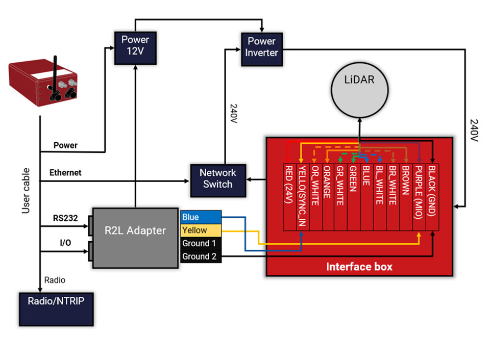
In many commercial organizations, millisecond-level device synchronization as offered with network time protocol (NTP) is sufficient. However, in surveying and automotive testing environments where there is more than one clock source (lidar and inertial navigation systems, or INS, for example), final results can suffer from time drift if millisecond — and not microsecond — synchronization is used.
Time drift becomes relevant as soon as you introduce more than one data acquisition system working in parallel. This is because each system will have its own timing error, and over time this error will grow and create drift.
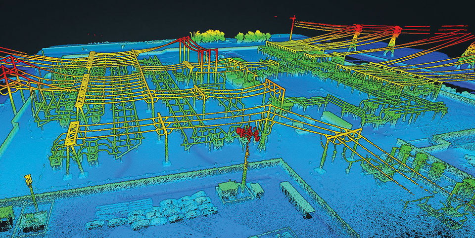
For surveyors, time drift can negatively impact point clouds by making object recognition difficult, subsequently leading to blurring and double vision.
For automotive engineers, when running campaigns, analysis of events within your data may be misaligned, making the analysis more difficult and/or less efficient.
Stamp out time drift
To stamp out time drift, it is important to use the most accurate clock source available.
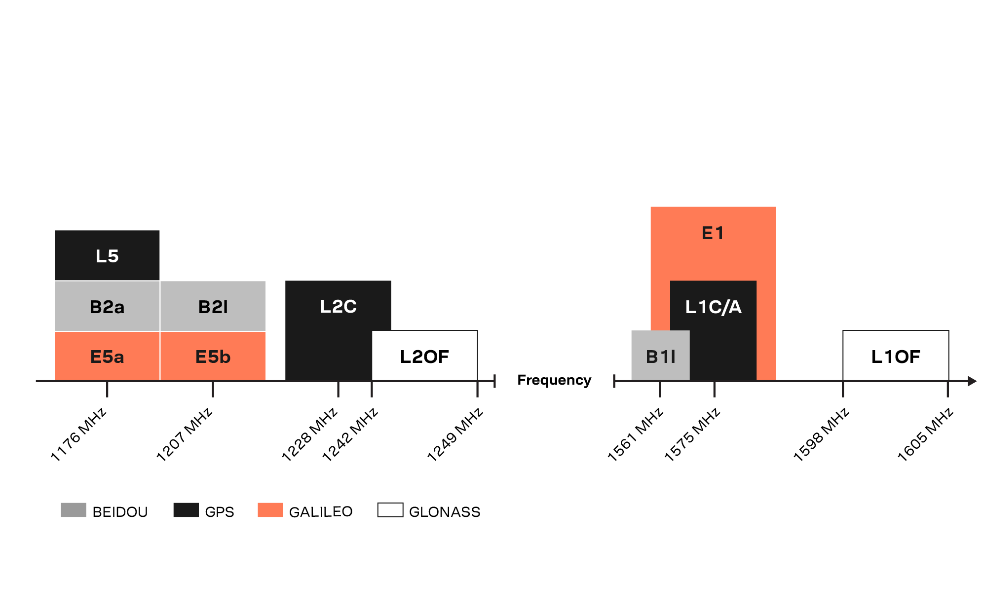
A key component of an INS is the GNSS receiver. The GNSS receiver acquires data, including timing information, directly from multiple GNSS constellations (GPS, GLONASS, BeiDou and Galileo). The GNSS receiver, coupled with the inertial measurement unit within the INS, allows users to benefit from the centimeter-level position accuracy that is so important in surveying and automotive testing environments.
These satellite systems house the most accurate time source possible — atomic clocks — meaning that devices connected to a network that includes an INS can take advantage of this time source owing to the GNSS receiver within the INS.
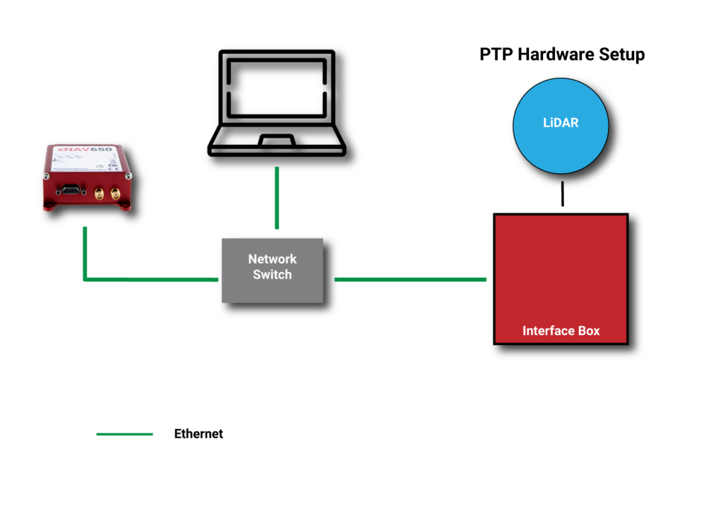
Simpler setup for lidar use
By migrating from a traditional PPS hardware set-up, which involves connecting and wiring multiple cables, to a PTP setup, which is essentially an Ethernet “plug-and-play” solution, users can also make day-to-day use of the equipment simpler and more efficient.
Without PTP – using PPS setup. (Image: OxTS)An example PPS hardware setup with a PTP-enabled network. (Image: OxTS)
This much-improved hardware setup allows surveyors and automotive test engineers to be up and running in a much shorter time frame than previously possible.
Adding value to the automotive industry
The addition of PTP also adds value for automotive users. With cars-under-test incorporating multiple sensors (lidars, cameras, etc.), synchronizing all that data can help support accurate analysis after the test is complete.
OxTS is continuing to develop its PTP solution by working on PTP slave functionality and improving the configuration process, which will provide greater flexibility in typical automotive setups that use data acquisition (DAQ) for larger sensor networks.
Summary
PTP as a time synchronization method is becoming more popular, particularly in the lidar industry, with manufacturers such as Ouster and Hesai enabling PTP on their sensors.
The shorter “time to survey” gives customers a much-enhanced user experience, and the higher quality final output on offer means that many users will demand their sensors are PTP-compatible before considering them for their projects.
Manufacturers of complimentary sensors, such as INS, need to build the capability into their product sets to allow them to be fit for the future.
Various OxTS INS are available to use PTP, including the new xNAV650, the company’s new small, lightweight and affordable INS for applications where payload size and weight matter. Learn more about the xNAV650 INS.
Users can also find out more about OxTS and its range of PTP-enabled devices by visiting its dedicated landing page, OxTS PTP-enabled INS devices.
Lidar and photogrammetry payload maker Rock Robotic has finished development of its new Rock R2A payload. Featuring the Livox Avia lidar scanner mounted on an aluminum enclosure, the R2A is light enough to fly on the DJI Matrice 200 and 210 series (versions 1 and 2), Matrice 300 RTK, Matrice 600 Pro, Freefly Alta X and many custom platforms.
A major factor in Rock Robotic’s success has been its use of Inertial Labs’ inertial navigation systems in its payloads. The Rock R2A uses the INS-D-OEM, which features temperature-calibrated and precisely aligned tri-axis micro-electromechanical accelerometers and gyroscopes.
With 20 years in the position, navigation and timing industry, Inertial Labs has been able to develop hardware solutions integrating many different types of sensors to ensure accurate time synchronization among independent data packets, resulting in a guaranteed high-performing system-level solution.
These high-quality systems and components, paired with a robust onboard Kalman filter, result in trajectories with heading accuracies of 0.03 degrees and pitch-and-roll accuracy of 0.006 degrees. These values directly affect point-cloud accuracy, which for the Rock R2A means a system accuracy of 5 centimeters or less.
The advent of drone lidar payloads has had a profound impact on industrial inspections such as for powerlines, saving labor costs and improving safety. The multiple return method of scanning with the Livox Avia and excellent position and orientation accuracy from the INS-D-OEM ensure that the R2A provides a highly dense and accurate point cloud for powerline classification.
“The Inertial Labs team has a deep understanding of the whole navigation technology ecosystem,” said Rock Robotics CEO and Co-Founder Harrison Knoll (known on YouTube as Indiana Drones). “This has made their products offer world-class performance and maintain easy integration and interoperability with GNSS receivers and onboard computer systems.”
New modules enable users to develop high-precision solutions for heavy machinery, ground robotics, and unmanned aerial vehicles (UAVs).
U-blox’s latest multi-band high-accuracy timing modules concurrently support L1 and L5 GNSS signals. The ZED-F9T-10B and LEA-F9T-10B timing modules, and the RCB-F9T-1 timing card, deliver nanosecond-level timing accuracies required to synchronize cellular network base stations and smart power grids. The ANN MB1 L1/L5 multi-band antenna completes the offering.
The multiband capability compensates for ionosphere error from all GNSS satellite constellations and reduces the timing error under clear skies to less than 5 ns without the need for an external GNSS correction service. To achieve maximum performance, the modules track signals from as many satellites as possible.
Image: u-blox
With satellite constellations transmitting signals on the L5 band nearing completion, the L1/L5 signal combination is becoming a viable option to complement products based on L1 and L2 signals. Modernized L5 signals are expected to deliver improved performance, especially in difficult urban conditions. Because L5 signals fall within the protected aeronautical radionavigation service (ARNS ) frequency band, they are also less subject to RF interference.
The LEA-F9T-10B provides a temperature range extended to –40 to +105° C. Both timing modules include a suite of advanced security features, including:
Improved anti-jamming and anti-spoofing technologies detect and flag malicious RF interference.
Secure boot ensures that the modules can only boot with authentic firmware.
Secure interfaces prevent intruders from tampering with the messages between the receiver and the host system.t
The ANN-MB1 L1/L5 multi-band antenna supports the GPS, GLONASS, Galileo and BeiDou, and addresses the scarcity of options in the nascent L1/L5 high-precision antenna mass-market, simplifying testing and deployment of L1/L5 multi-band GNSS solutions. Magnetic and fixed mounting options help meet diverse installation needs.
The new products targets developers in industrial navigation and robotics interested in high-precision positioning technology to locate UAVs, ground robots and agricultural equipment accurately and in real time.
Engineering samples of the u-blox ZED-F9T-10B, RCB-F9T-1 and ANN-MB1 will be available in May, followed by the LEA-F9T.
Advanced Navigation, in partnership with quantum technology company Q+CTRL, will create a quantum-enhanced inertial navigation solution for space launch vehicles, satellites and landers. The design of this inertial navigation technology for long-endurance space missions will be pivotal to NASA’s space exploration initiative, the Artemis Lunar Exploration Program.
The work will be done under a Moon to Mars Supply Chain Capability Improvement grant by the Australian federal government.
The quantum-enhanced navigation system will enable NASA and its partners in the international space exploration community to execute deep space, lunar and planetary missions that were previously not possible.
Artemis is NASA’s human lunar exploration plan, with the program aiming to send the first woman and next man to the surface of the Moon by 2024. Scientists have long acknowledged the Moon as a rich source of information regarding Earth and the Solar System. Using the findings from the Moon. NASA will then prepare to launch missions to Mars.
To meet NASA’s space exploration initiatives, high-end, highly accurate inertial navigation technology is vital to the mission’s success. The groundbreaking inertial navigation systems developed by Advanced Navigation have been recognised by the international aerospace community as a superior technology to help pioneer a new age of space exploration and discovery for humanity.
For Advanced Navigation, this is just the beginning. “In the long-term view of this critical initiative, team activities following this project will establish an ongoing manufacturing opportunity and capacity that is central to the emerging Australian space industry,” said Chris Shaw, co-CEO of Advanced Navigation.
Advanced Navigation was founded in Sydney in 2012 by engineers Xavier Orr and Chris Shaw to commercialize thesis research into AI neural network-based inertial navigation. The first product met the market with great success and the company expanded rapidly adding a portfolio of navigation offerings and moving into a diverse range of deep tech fields such as underwater acoustics, GPS, radio frequency systems, sensors and robotics.
Today Advanced Navigation is a supplier to companies including Airbus, Boeing, Tesla, Google, Apple and General Motors. Advanced Navigation is headquartered in Sydney with a large research facility in Perth and sales offices around the world.
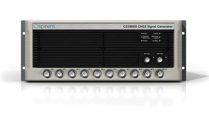
Among the enhancements, a doubling of the update rate means the GSS9000 series now offers the ability to recreate operations more precisely and realistically, reducing uncertainty in positioning, navigation and timing (PNT) testing.
The latest developments provide the GSS9000 series with the ability to run simulations at a software and hardware update rate of up to 2 kHz, improving accuracy of the simulated trajectory without compromising performance. This is of particular benefit to high-dynamics applications, such as space missions and hypersonic vehicles. The increased update rate also delivers lower latency for hardware-in-the-loop (HIL) testing, further reinforcing the GSS9000’s position as the industry’s most accurate and realistic test instrument.
“Our dedicated hardware and powerful software solutions are built specifically with PNT test in mind — to improve accuracy, increase flexibility and provide high-performing systems to meet customer needs,” said Adam Price, Spirent director of PNT simulation. “These latest enhancements to the GSS9000 continue to raise the bar for highly flexible and scalable solutions that enable our customers to stay ahead of their competition.”
Other enhancements to the GSS9000 Series include:
Extended Scenario Duration. In a simulation environment, where control and repeatability are key for a realistic representation of the mission, reducing the number of user inputs is essential. The new update will extend the available scenario duration to 65 days, using the same initial conditions for the simulation throughout the duration of testing to deliver uninterrupted high-performance simulation for longer.
Enhanced Embedded Interference Capabilities. To provide greater power and flexibility in interference testing, Spirent has improved support for interference testing on wide spectrum signals, increased bandwidth resolution and repetition rates, and added variable bandwidth control on additive white Gaussian noise (AWGN).
“Spirent’s leadership in GNSS testing comes from the combination of our unrivalled heritage and deep understanding of the PNT market, alongside our continuing commitment to improving test capabilities for customers,” said Ricardo Verdeguer Moreno, product line manager for high-end applications. “By working closely with customers, we are able to better understand the challenges they face, and these latest enhancements to the GSS9000 series demonstrate how we are continuing to help customers reduce uncertainty by providing more accurate operations, without impacting system performance.”
The enhancements to the Spirent GSS9000 series will be available to new and existing customers at the beginning of the second quarter of this year. For more information, visit the GSS9000 Series product page. U.S. government and prime contractors should contact Spirent Federal for details.
KVH has been developing and testing the PIC technology for more than three years and is continuing to roll the technology into existing product lines.
KVH’s PIC technology features an integrated planar optical chip that replaces individual fiber optic components to simplify production while maintaining or improving accuracy and performance. KVH’s IMUs with PIC technology are designed to deliver improved bias stability and 20 times higher accuracy than other micro-electromechanical systems (MEMS) IMUs.
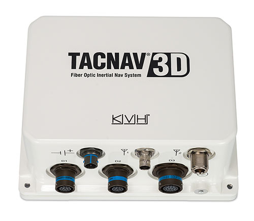
The fiber-optic gyro (FOG)-based TACNAV 3D tactical navigation system provides an assured positioning, navigation and timing (A-PNT) solution with an embedded GNSS and optional chip-scale atomic clock (CSAC). TACNAV 3D’s modular tactical design enables it to function as a standalone inertial navigation solution and as the core of an A-PNT-capable multi-functional battlefield management system.
“We are pleased to incorporate our newest technology into the TACNAV 3D,” said Dan Conway, executive vice president of KVH’s inertial navigation group. “We are committed to ensuring that this battle-proven system provides the precise navigation that is vital to mission success and addresses the military demand for assured positioning, navigation, and timing (A-PNT) solutions.”
KVH’s TACNAV solutions are being used in vehicles that operate in demanding environments, from battle tanks and M-ATVs, to armored vehicles, reconnaissance and combat support vehicles.
Defense forces using TACNAV systems include the U.S. Army and Marine Corps, as well as many allied customers including Australia, Botswana, Brazil, Canada, Egypt, France, Germany, Great Britain, Italy, Malaysia, New Zealand, Poland, Romania, Saudi Arabia, Singapore, South Korea, Spain, Sweden, Switzerland, Taiwan and Turkey.
OSNMA (Open Service Navigation Message Authentication) offers end-to-end authentication on a civilian signal, protecting receivers from spoofing attacks.
OSNMA is being pioneered by the Galileo Program, with Septentrio providing a testbed for this technology from the end-user point of view. The anti-spoofing capabilities of OSNMA will complement Septentrio’s already available anti-jamming technology, AIM+, and further strengthen the overall security of Septentrio GNSS receivers.
“The authentication of the Galileo signal using the OSNMA technology is yet another first that we are pleased to share with our close partner ESA [European Space Agency],” commented Bruno Bougard, R&D director at Septentrio. “Septentrio is proud and thankful to be able to contribute to the realization of one of Galileo’s key differentiators. “
With OSNMA, Galileo is the first satellite system to introduce an anti-spoofing service directly on a civil GNSS signal.
OSNMA is a free service on the Galileo E1 frequency. It enables authentication of the navigation data on Galileo and even GPS satellites. Such navigation data carries information about satellite location — if altered, it will result in wrong receiver positioning computation.
While currently in development, OSNMA is planned to become publicly available in the near future. GPS is experimenting with satellite-based anti-spoofing for civil users with its Chimera authentication system.
Within the scope of the FANTASTIC project led by GSA, OSNMA anti-spoofing protection was implemented on a Septentrio receiver.
“Septentrio is committed to providing highly accurate and secure positioning and timing solutions to industrial applications and critical infrastructure. This is another example where Septentrio demonstrates its leadership in end-to-end GNSS receiver security with its breakthrough anti-jamming and anti-spoofing technology,” said François Freulon, head of Product Management at Septentrio. “Thanks to our future proof products, we will be rolling out OSNMA in our portfolio as soon as it is available. This will further enhance the security of our receivers, ensuring robust, trustworthy and reliable operation even in the most challenging environments.”
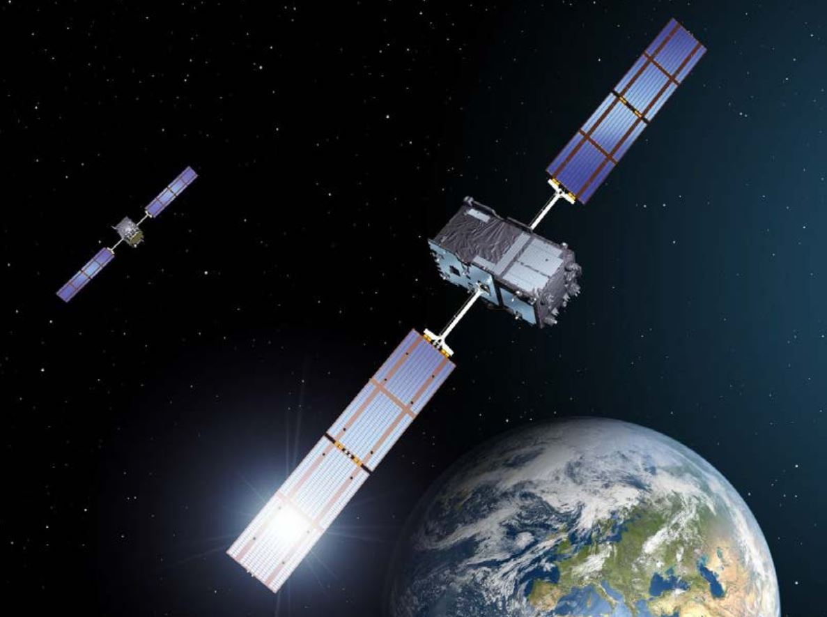
European Galileo satellites provide an open authentication service on the E1 signal and a commercial authentication service on the E6 signal. (Image: European Space Agency)
ESA and GSA (European GNSS Agency) have now commenced the testing phase of the OSNMA authentication, which will continue during the coming months. To find out more about spoofing and OSNMA, see this article. For more information about GNSS signals and the value they bring, see Septentrio’s free webinar More GNSS signals: What’s in it for you?
New Galileo OS SIS ICD V2.0 is now fully supported by IFEN’s NCS Nova GNSS simulator
Photo: IFEN
IFEN GmbH, a manufacturer of GNSS navigation test products and services, announced that its NCS Nova GNSS simulator now fully supports the simulation of Galileo Open Service (OS) signal improvements based on the new Galileo OS SIS ICD V2.0.
The NCS Nova GNSS simulator is a high-end, powerful and easy-to-use satellite navigation testing and R&D device. It is fully capable of multi-constellation and multi-frequency simulations for a wide range of GNSS applications. It provides multiple GNSS frequencies in one box.
A key enhancement to the NCS Nova GNSS simulator is comprehensive support of new Galileo OS signal message improvements on E1B. By enabling real-time simulation of the Galileo OS message improvements, the NCS Nova GNSS Simulator expands the user’s Galileo signal capability.
The NCS Nova GNSS simulator will, in future, also fully support the new Galileo E1B OS-Navigation Message Authentication (OS-NMA) and Galileo E6B High Accuracy Service (HAS) capabilities.
The GNSS simulator enhancements were developed through ESA’s Navigation Innovation and Support Programme (NAIVSP) Element 2, within the project STX2G.
“Through a simple software update, NCS Nova GNSS Simulator customers can automatically generate the new Galileo signal capabilities,” said Günter Heinrichs, head of Client Solutions at IFEN. “Adding Galileo OS signal improvement support to our NCS Nova GNSS simulator comes at the perfect time given the recent release of the Galileo OS SIS ICD V2.0 specification.”
In our 10th annual Simulator Buyers Guide, we feature simulator tools, devices and software from 10 prominent companies that aid GNSS receiver manufacturers in product design.
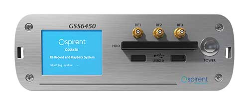
The GSS6450 RF record and playback system. (Photo: Spirent)
GSS9000, SimMNSA, CRPA test system, anechoic chamber testing, mid-range testing
Spirent Federal Systems provides PNT/GNSS test equipment that covers all applications, including research and development, integration/ verification, and production testing.
GSS9000. The GSS9000 Series Multi-Frequency, Multi-GNSS RF Constellation Simulator is Spirent’s most comprehensive simulation solution. It can simulate signals from all GNSS and regional navigation systems and has a recently-enhanced system iteration rate (SIR) of 2 kHz (0.5 ms), enabling higher dynamic simulations with more accuracy and fidelity. The GSS9000 supports restricted/classified signals, Alt RF, and other non-GNSS sensors. Users can evaluate the resilience of navigation systems to interference and spoofing attacks, and have the flexibility to reconfigure constellations, channels, and frequencies between test runs or test cases.
The GSS9000 Constellation Simulator. (Photo: Spirent)
SimMNSA. Spirent Federal has the first fully-approved MNSA M-code simulator. Authorized users of the GSS9000 series of simulators will be able to utilize the advanced capabilities of SimMNSA to create more robust solutions for their customers. SimMNSA has been granted security approval by the Global Positioning System Directorate.
CRPA Test System. Spirent’s Controlled Reception Pattern Antenna (CRPA) Test System generates both GNSS and interference signals. Users can control multiple antenna elements. Null-steering and space/ time adaptive CRPA testing are both supported by this comprehensive approach.
Anechoic Chamber Testing. Spirent’s GSS9790 Multi-Output, Multi-GNSS RF Constellation Wave-Front Simulator System is a development of the GSS9000. The GSS9790 provides the core element for GNSS applications that require a test system that can be used in both conducted (lab) and radiated (chamber) conditions.
Mid-Range Solutions. Spirent also offers solutions that cater to intermediate GPS/GNSS testing needs. The GSS7000 multi-constellation simulator provides an easy-to-use solution for GNSS testing that can grow with users’ requirements. The GSS6450 RF record and playback system enables repeated replay of a real-world GNSS/GPS test in the lab.
CAST-CRPA. The CAST-CRPA Simulation System produces a coherent wavefront of GPS RF signals to provide repeatable testing in the laboratory environment or anechoic chamber. The CAST CRPA system is configurable for any number of coherent outputs that users want.
With an intercard carrier-phase error of less than 1 millimeter, the CAST-CRPA Simulation System is extremely accurate.
The system generates a wavefront of GPS signals when its GPS RF generator cards are operated in a ganged configuration. Each generator card provides a set of GPS satellites coherent with the overall configuration. Several RF generator cards may be utilized together, ensuring phase coherence among the signal generator cards in each bank. The CRPA antenna, the antenna electronics and the GPS receiver can be tested as a unit with or without radiating signals.
CAST-CRPA features
Generates single coherent wavefront of GPS signals
Orolia advanced GNSS simulators offer a wide breadth and depth of simulation tools to test mission-critical positioning, navigation and timing (PNT) applications and scenarios. They are feature-rich and easy to use, providing a way to harden GPS/GNSS-based systems without the limitations of live-sky testing.
Skydel — Advanced Software-Defined Simulators
Skydel Simulation Engine. This flexible, high-performance simulator transmits GNSS digital signals in real time to many kinds of software-defined radios. Skydel uses graphics processing units (GPUs) to compute the digital GNSS signals of all simulated satellites, scaling from simple to complex use cases. Skydel simulates civil signals from global and regional navigation satellite systems, many kinds of GNSS receiver trajectories with high dynamics, and advanced jamming and spoofing. All Skydel models offer these features:
Easy configuration with intuitive UI and automation
Support for global constellations and frequencies
Support for jamming, spoofing and repeating, including jamming waveforms
Comprehensive API (Python, C#, C++, LabVIEW)
Advanced signal customization and scenario creation
Ability to integrate interference with no additional hardware
1000-Hz simulation iteration rate
IQ file generation and playback
Ability to record and export user interactions as Python script
GSG-8. This software-defined system GSG8 is a globally available hardware platform for aerospace and critical infrastructure applications. It will support future EU encrypted signals. The rack-mounted unit has the option of one to four RF outputs and is configurable.
BroadSim. Designed for military NAVWAR applications, the BroadSim software-defined simulator supports encrypted military codes (Y-code, M-AES and M-MNSA) and provides documentation and procedures for classified operations. BroadSim has two GPUs and four RF outputs. It runs on a custom Linux operating system, with RMF STIG support coming soon.
Skydel Anechoic. This simulator system for radiated over-the-air testing is designed for testing CRPA/multi-element antennas, antenna electronics and entire PNT systems in an anechoic chamber.
Skydel Wavefront. This GNSS simulator system for conducted wavefront testing is designed to test the jamming/spoofing resiliency of CRPA and multi-element antenna electronic systems, and for applications with high dynamics.
GSG 5/6 Scenario-Based Simulators. The GSG 5/6 enable testing of smart applications such as drones, the internet of things, connected cars and cellular. They provide a comprehensive set of pre-defined scenarios and the ability to create scenarios. They simulate all constellations and frequencies as well as movements and trajectories anywhere on or above Earth.
Application packages are available for real-time kinematic, eCall, high-velocity, jamming and sensors.
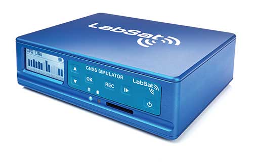
LabSat 3 Wideband. The LabSat 3 Wideband is a compact yet powerful multi-constellation and multi-frequency GNSS testing solution. The easy-to-use, one-touch record-and-replay function provides an efficient way to test and develop GNSS-based technology without the cost and limitations of live-sky signals.
It is lightweight and portable and makes it easy to collaborate with colleagues by sharing scenario files over the internet — making it a suitable testing partner for remote working. Additionally, the removeable solid-state drive (an SSD of up to 7 terabytes) and a two-hour runtime provided by an internal battery is ready for field testing in any environment.
LabSat 3 Wideband can record and replay up to three different channels at 56-MHz bandwidth across all major constellations and signals, including:
GPS: L1/L2/L5
Galileo: E1/E1a/E5a/E5b/E6
GLONASS: L1/L2/L3
BeiDou: B1/B2/B3
NavIC: L5/S-band
QZSS: L1/L2/L5
L-band correction services including SBAS
2x CAN and 4x digital input channels tightly synchronized with GNSS data
Future signal launches are also supported, including L2C, L5 and L1C
SatGen Simulation Software. SatGen software allows users to quickly create bespoke, accurate scenarios with their own time, location and trajectory that can be replayed via a LabSat GNSS simulator.
The latest version of SatGen can be used to create a single scenario containing all the upper and lower L-band signals for GPS, Galileo, GLONASS, BeiDou and NavIC.
High-end GNSS simulation solutions for R&D, integration and product testing
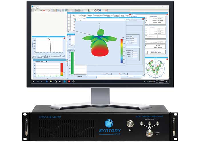
Constellator. Syntony’s GNSS simulator Constellator supports all constellation signals available and provides a high level of service in different ranges. It covers, in a single unit, a wide spectrum of use cases from entry-level with L1C/A up to very demanding configurations such as multifrequency and up to 660 L1C/A-equivalent signals. Extensively used in aeronautics, space and defense industries, Constellator answers complex requirements:
Standalone mode (on the ground and in space)
Multi-frequencies
All constellations and their signals, including BeiDou, Navic/IRNSS and QZSS
Hardware-in-the-loop (HIL) mode with zero effective latency and 1000-Hz update rate
CRPA generation capability
Capability to generate “Restricted Signals” through a dedicated interface, called PRN-Link
In the space industry, Constellator implements the advanced models (Earth gravity, drag, 3D ionospheric models, side lobes, etc.) needed to achieve accurate simulations for all kinds of orbits (from LEO to GEO and SSTO). Combined with other Syntony GNSS simulation products (interference generator, Echo recorder and player), Constellator can tackle challenging use cases such as testing of jamming, spoofing, multipath and multiple antennas. It is based on a software-defined radio, making it hardware-ready for future constellations, signals and codes. It is easily upgradeable and versatile.
GNSS Recorder and player. Echo is an ultra-high-fidelity GNSS record-and-playback solution that captures real-life signals and environments — for instance, from airplanes — and then replays them for R&D or production tests. Echo offers:
3 RF channels of 100-MHz bandwidth each (for the whole set of GNSS signals from all constellations)
16-bit resolution (I&Q)
From seven to more than 1,000 hours of record/replay capabilities depending on the configuration
The Echo platform allows full 16 bits of I/Q recording at 100 Mhz for three channels, simultaneously. As such, it provides the highest achievable record/replay fidelity. Echo-R can also record complex and very long realistic scenarios from a simulator. Echo-P can replay them with very high fidelity for long-run or production tests.
Please contact Remy Thellier (based in San Francisco) for North America at 415.599.9230, or contact the EMEA Sales team at: [email protected] syntony-gnss.com
+33.5.81.319.919
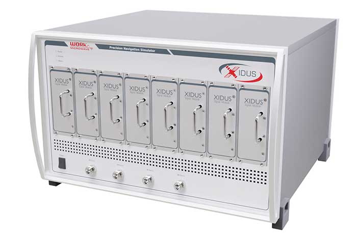
The advanced customization and configurability of Xidus enables users to perform rigorous and extensive testing of GNSS systems.
Test scenarios. Xidus meets all requirements regarding multi-GNSS, multi-frequency and multi-RF signal generation out of the box. Innovative Xidus signal extension and enhancement (SEE) technology allows users to integrate bespoke generation blocks into the signal generation path. In addition, Xidus’ advanced support capabilities allow remote support and updates, remote training and even remote scenario execution.
Easy hardware or software upgrades. Xidus has modular signal generation hardware that allows easy and robust field upgrades. New modules are automatically calibrated, allowing users to accomodate multiple concurrent navigation development projects.
Expert background. WORK Microwave has been designing and building GNSS simulators for more than 15 years. The Xidus hardware leverages WORK Microwave’s 35+ years of experience in the design and manufacturing of bespoke digital and analogue microwave products.
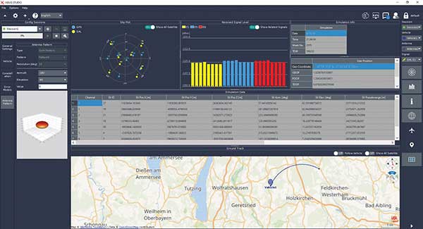
Xidus-Studio (Photo: Work Microwave)
Xidus-424 GNSS Simulator. The Xidus-424 has up to 128 LOS channels, 512 multipath channels and two RF outputs. It supports all GNSS frequencies and signals. It supports an update rate up to 100 Hz and has very wide dynamic power range configurability.
Xidus-648 GNSS Simulator. The Xidus-648 provides all the capabilities of the Xidus-424 plus additional features: up to 256 LOS channels, 1,024 multipath channels, four RF outputs and a 1000-Hz update rate.
Xidus-Studio client software. The software provides everything for testing GNSS systems: different vehicle models with 6DOF, multiple vehicle simulation, spoofing and meaconing, multiple TX antenna patterns, multiple RX antenna patterns, industry-standard error models and runtime distortions on individual channels. Xidus-Studio also allows the design of bespoke satellite orbits ranging from LEO to GEO. Available on Linux and Windows.
Xidus Series. Connect up to four Xidus units to produce a simulator capable of mega-constellation simulation, with precise phase synchronization across units.
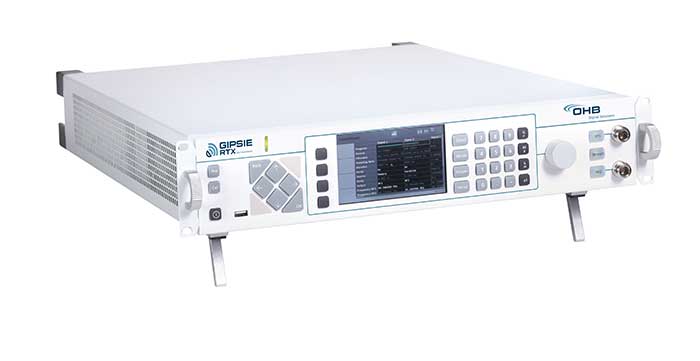
GIPSIE-RTX (GNSS Multisystem Performance Simulation Environment – Real Time Extension)
GIPSIE-RTX is a fully featured GNSS signal generator with real-time streaming functionality, including real-time control of the simulation environment. It consists of a high-quality signal simulator as the hardware platform and a flexible and powerful GNSS simulation environment.
The multi-system and multifrequency-capable GIPSIE-RTX simulates arbitrary satellite orbits using a sophisticated orbit integrator. It is able to model all error sources, delays and propagation effects. These include various models for satellite clocks, ionosphere and troposphere, multipath, signal power, antenna patterns and noise. In addition, multiple types of signal interference, like jamming and spoofing, can be defined. Customized navigation message formats and contents can be used to simulate future GNSS signal features.
Besides generating RF signals, GIPSIE-RTX is also capable of directly simulating digital signals, taking into account user-defined modeling of a radio-frequency front end. Comprehensive data logging of all intermediate results is available for detailed analyses.
GIPSIE-RTX provides a real-time input interface and thus supports hardware-in-the-loop (HIL) testing, such as for automotive applications.
GIPSIE-RTX Features
GIPSIE-RTX is a new compact multi-channel high performance platform for complex and versatile GNSS testing. Features include:
Highly reproducible scenarios
Modeling of all error sources, delays and propagation effects
Interference (jamming and spoofing) simulation
HIL simulation
Synchronization of multiple simulators for advanced testing (e.g., array antenna)
QA707 is the cutting edge solution for global threat GNSS awareness and management. It is a GNSS simulator specifically designed to test cyber-attacks and authentication, and includes the simulation of GNSS interference, deception, jamming, spoofing and advanced cyber-threats such as data and code level attacks.
The high flexibility in the creation of the scenarios and the definition of the type of attacker allow cyber-threat and vulnerability testing for several applications,These applications may include, for example, autonomous driving and vehicle tracking, aeronautics and high dynamics applications, space GNSS receivers and timing.
OSNMA support. The Galileo Open Service Navigation Message Authentication (OSNMA) simulation is an opportunity to test the new Galileo data protected service against a number of known vulnerabilities in GNSS applications. The OSNMA simulator is also available as a standalone tool, allowing the generation of OSNMA data that can be used with third party simulators.
PC-capable. QA707 runs on a standard PC. It is compatible with several third-party hardware RF up-converters, including National Instruments’ USRP. Additionally, it can support customer-specific hardware through the hardware API interface.
QA707 main features
Multi constellation (currently GPS L1, GALILEO E1, SBAS L1).
Galileo OSNMA
RF simulation, binary file dump, signal record and replay
Support to SDR platforms and open API for custom RF upconverters
Runtime streaming of scenario information over UDP (motion, channel data)
Data level cyber-attacks
Accurate spoofing signals control, trajectory spoofing, signal replay attacks
Narrow band, wide band, frequency modulated jamming
Integrity threats (on request): evil waveform, erroneous ephemerides, code/carrier divergence, low satellite signal power, excessive range acceleration
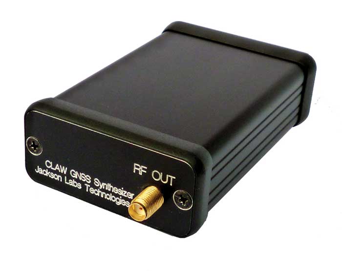
The 18-channel miniature full-constellation CLAW GPS Simulator is a fully self-contained, low size, weight, power and cost (SWaP-C) miniature GPS simulator. It is very popular in manufacturing environments as well as R&D applications that require consistent and repeatable local GNSS signals at low price points.
The CLAW simulator does not require external computers for processing and control — it works fully self-contained by simply applying power, and storing location/time/date data in internal non-volatile (NV) memory, or by storing complex vector data to simulate highly dynamic scenarios.
The CLAW also can be used to transcode NMEA or SCPI position/velocity/time (PVT) data into GPS RF signals. JLT offers an easy to use, highly configurable and cost-free SimCon Windows application program that is downloadable from the JLT website.
The SimCon application allows random scenario generation and is thus usable to simulate leap-second events, week 1023 rollover events, or any other GPS live-sky scenarios, including highly complex yet easy-to-create dynamic vector simulations.
For authorized U.S. government users, a version that does not have altitude and velocity limitations is popular for low-Earth-orbit (LEO) simulations. Multipath simulation allows use of the entire 18-channel simulator capability.
The unit can be field-upgraded with an easy to use in-field software upgrade feature. The CLAW is also very useful in GNSS receiver sensitivity testing for R&D or mass-production assembly lines as it allows accurate control of RF output power ranging from –100 dBm to less than –130 dBm with 0.1-dB resolution and typically better than 1-dB accuracy over the controllable power range.
The CLAW GPS Simulator also has a built-in RF signal generator with sweep, CW and random noise functions that are useful in simulating GNSS jamming scenarios, as well as GPS spoofing scenarios. The simulator comes in an FCC-certified metal desktop enclosure with numerous accessories.
For 2021, the CLAW firmware has been updated to allow live-sky almanac and ephemerides to be automatically uploaded from various externally connected GNSS receivers. This makes simulations using real-time live-sky constellations (such as used in simulating spoofing attacks) an easy task. A free firmware update is available from JLT.
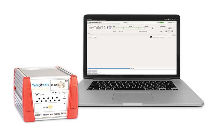
The MGSE product family creates a versatile GNSS test and simulation environment that improves the development, qualification and certification process of GNSS receivers within development phases and for the validation and certification in end-to-end tests.
MGSE enables mobile and stationary interference monitoring, such as for protecting critical infrastructures (based on MGSE REC), and can be used for interference mitigation if combined with TeleOrbit’s GNSSA-6E (six-element antenna array) or its GNSSA-DCP (dual circularly polarized antenna).
With MGSE REC-REP 2.0 users can, among other tasks, record Galileo PRS signals in a real user environment and replay them for Galileo PRS receiver testing. It is also possible to replay simulated GNSS signals.
MGSE SIM-REP supports the development of software-defined radios/receivers (SDR) or specialized algorithms by creating a simulation environment that provides the possibility and flexibility to use synthetically generated GNSS data and recorded real-world samples — both exactly reproducible.
For jamming and spoofing test and evaluation, TeleOrbit offers a sophisticated solution based on the MGSE simulation, recording and replaying product family.
Technical background. The multi-band RF front-end (MGSE REC) receives the GNSS RF signals in different frequency bands simultaneously to obtain digital IF data, which can be used for GNSS multi-system signal analysis and comparison.
MGSE REC also includes a reception board to receive and process the NavIC S-band signal in addition to other L-band frequencies.
The MGSE Replay Unit (MGSE REP) includes a flexible multi-band RF replay device that can stream simulated and recorded raw IF data to a digital baseband output or to an analog RF signal.
MGSE REP simultaneously supports up to two independent RF channels and up to four GNSS signals, such as L1, E1, B1, G1.
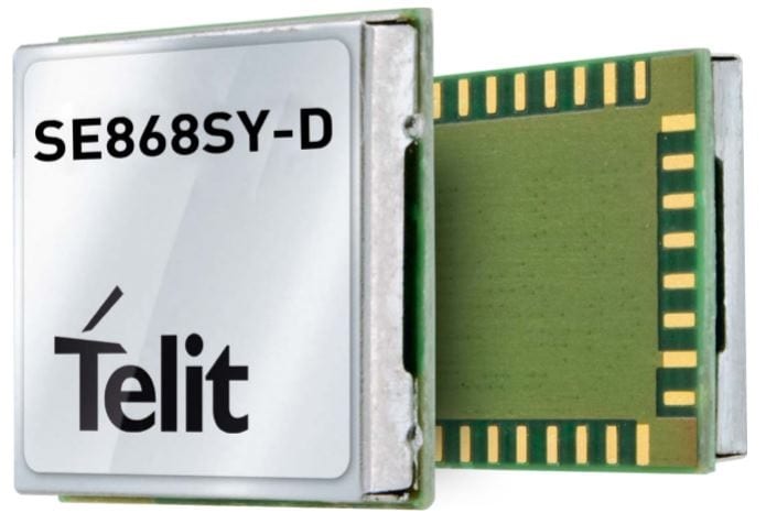
Telit has launched the SE868SY-D multi-frequency, high-precision GNSS receiver module for applications that require high accuracy, fast updates, multi-constellation support and multipath resistance.
At 11 x 11 mm, the SE868SY-D accommodates ultra-compact devices and IoT trackers.
Available now, the high-precision SE868SY-D module is Telit’s first multi-frequency, multi-constellation GNSS receiver module, featuring an ultra-sensitive -167 dBm (tracking) RF front end. By using both the L1 and L5 bands, the SE868SY-D supplies a significantly higher location accuracy than single-frequency devices — even in high-multipath environments such as urban canyons, Telit said.
This sub-1-meter precision is a major reason ABI Research expects more than 1 billion multi-frequency GNSS devices to ship annually by 2023.
The SE868SY-D is the first product from a new strategic collaboration between Sony and Telit, and features Sony’s next-generation CXD5610 GNSS receiver large-scale integrated circuit (LSI).
The Telit SE868SY-D is designed for battery-powered applications such as IoT trackers and wearables. With less than 45 mW in L1+L5 tracking mode, the module has low power consumption, despite using both L1 and L5 bands.
For high-dynamic applications, the SE868SY-D a high update rate of up to 25 Hz. Its high-accuracy, one-pulse-per-second signal also makes the module suitable for timing applications.
“With the new SE868SY-D, Telit is uniquely prepared to meet the burgeoning global demand for multi-frequency, multi-constellation GNSS receivers for IoT trackers, wearables and more,” said Eric Lagorce, Telit business development director. “The SE868SY-D also perfectly complements Telit’s two decades of GNSS expertise and its broad portfolio, and highlights the potential of our strategic collaboration with Sony.”
The Telit SE868SY-D provides pin-to-pin compatibility for applications based on Telit’s legacy GPS module JF2 and GNSS module SE868V3.
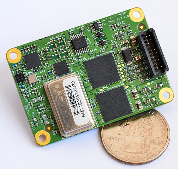
The STL-2600 STL-capable receiver provides a GNSS-independent low SWaP-C UTC-time and location capability
Jackson Labs Technologies Inc. (JLT), a designer and manufacturer of GNSS, timing and frequency equipment, has announced the availability of the STL-2600 Satellite Timing and Location (STL) receiver designed in partnership with Satelles Inc., the STL service provider.
The STL-2600 commercial receiver provides a completely GNSS-independent, low-cost capability to generate UTC nanosecond timing and meters-accurate positioning anywhere in the world. It operates in a way similar to GPS, but without GPS or GNSS. The STL signal has 30-db (1,000 times) higher power compared to GPS signals, allowing the receiver to operate deep indoors independent of any GPS/GNSS signal.
“Useful for non-GNSS-based E911 location and UTC(NIST) timing applications, the STL-2600 receiver is deployable today to fulfill critical infrastructure PNT objectives such as those outlined in Executive Order 13905 on the responsible use of PNT in the U.S. and the emerging mandates for a GNSS-independent backup solution in Europe,” said Said Jackson, president of JLT.
The STL-2600 receiver is also useful in marine applications where GNSS signals are regularly denied or manipulated and for stationary high-accuracy timing applications such as 5G.
The STL-2600 receiver can be directly connected to JLT’s GPS Transcoder products for glue-less retrofit capability of existing customer legacy GPS-only receiver systems to Galileo, GLONASS, BeiDou, QZSS and SBAS as well as adding the STL and optional atomic holdover capability to these legacy systems.
The receiver module combines a custom-designed STL L1 LEO receiver and a latest-generation concurrent-GNSS receiver with a disciplined high-stability reference oscillator sub-system on one circuit board.
Features and specifications of the STL-2600
Photo: JLT
Form factor: 1.4″ x 2.0″ x 0.5″ (36mm x 51 mm x 13mm)
Switching modes: User-selectable automatic and manual switching between GNSS and STL signal reception during jamming or manipulation events
Integration: Incorporates into user systems just like a legacy GNSS receiver would using NMEA and SCPI serial messages, with the use of standard NMEA messages for STL positioning and timing features making system integration trivially easy
Oscillator options and performance: Internal high-stability TXCO standard; capable of directly and gluelessly disciplining numerous optional DOCXO, CSAC and rubidium oscillators for holdover capability, with ultra-stable ADEV performance from 0.1s to infinity with better than 10E-12 stability when using a DOCXO or Rubidium as the holdover oscillator
Low-power consumption: Ranges between 0.7 W to 1.45 W (depending on configuration) allowing for long-term battery operation for use cases without AC power
Antenna support: One GNSS/STL combined standard; optional support of a second antenna for diversity
Interfaces: TTL serial port standard; optional USB serial port allow easy evaluation and design-in
Upgrades: One-button firmware updates performed in situ through any of the serial ports
The receiver includes JLT’s proven frequency and timing disciplining and holdover IP deeply embedded into the entire signal chain for ultra-low phase noise performance and high-stability 1PPS and 10 MHz operation, even when using only the built-in TCXO oscillator.
The unit operates fully autonomously from just a USB cable and is compatible with a customized version of the GPSCon software — offered at no cost to JLT customers — for monitoring and control.
The STL signal has been deployed worldwide since 2016 and can be evaluated and implemented SWaP-C-effectively today via this receiver module.
The STL-2600 is available now. Contact Jackson Labs Technologies for configuration and pricing information.
 Agreement focuses on increasing development and capacity for ultra-compact, low-power laser-beam scanners to expand the market