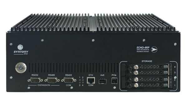
Syntony GNSS has introduced the Echo 4RP, the latest addition to its Echo series of GNSS record and playback systems. This new model builds on the capabilities of the Echo R&P, offering advanced features designed to address the evolving needs of GNSS testing and development.
The Echo 4RP expands its frequency range to include L, S, and C bands, surpassing the previous model’s coverage of 1100 MHz to 2550 MHz. This broader spectrum supports both current and emerging GNSS and non-GNSS signals, making it adaptable for diverse testing scenarios.
The system now supports up to four RF channels for simultaneous recording and playback, an increase from three in the earlier version. This enhancement enables complex testing setups, including multi-antenna configurations and Controlled Radiation Pattern Antenna (CRPA) applications, with precise phase synchronization.
The Echo 4RP delivers high-quality signal fidelity with options for 16-bit I&Q sampling at 93.75 MHz per channel or 8-bit I&Q sampling at 187.5 MHz per channel across all four channels simultaneously. These options provide flexibility to meet specific testing requirements.
Weighing less than 10 kilograms, the Echo 4RP combines portability with performance, making it suitable for both laboratory and field environments. Its compact design simplifies deployment without sacrificing functionality.
The system includes up to 32 terabytes of internal storage with a swappable SSD design, allowing extended recording sessions and efficient data handling.
The Echo 4RP is designed for a wide range of GNSS testing applications:
CRPA testing: Phase synchronization across all channels supports anti-jamming and anti-spoofing technologies for enhanced signal integrity.
GNSS spectrum analysis: C-band coverage allows exploration of new GNSS signals and services, aiding research into next-generation navigation technologies.
Septentrio, a division of Hexagon, has introduced two new products, the AsteRx RB3 GNSS receiver and the AsteRx RBi3 GNSS/INS system. These receivers are designed to operate in extreme environments, featuring IP69K-rated housings and components that have undergone rigorous ISO-standard testing.
The technologies robust construction ensures durability under heavy shocks, vibrations and challenging environmental conditions, making them suitable for demanding applications such as construction, mining and port automation.
The AsteRx RB3 and RBi3 utilize multi-frequency GNSS technology to deliver precise, centimeter-level positioning even in environments where GNSS signals are typically difficult to maintain. The receivers can be mounted externally on heavy machinery or integrated into chassis systems, offering flexibility in placement and simplifying installation.
The AsteRx RBi3 incorporates FUSE+ technology, which combines a high-performance GNSS engine with an industrial-grade inertial sensor. This integration provides accurate orientation data — such as heading, pitch and roll — alongside reliable positioning. In dual-antenna configurations, the receivers deliver sub-degree GNSS heading accuracy immediately upon initialization.
The AsteRx RB3 and RBi3 are ideal for machine guidance in industries requiring rugged equipment capable of maintaining precision under extreme conditions.
SBG Systems has released Qinertia 4.2, an updated version of its post-processing software for GNSS and inertial navigation system (INS) data. This release introduces several new features and improvements aimed at refining processing accuracy and usability, according to SBG Systems.
One of the notable additions is the beta version of Precise Point Positioning Fixed Ambiguity, which allows centimeter-level accuracy processing without the need for a base station. The update also includes a new RTS smoothing option, known as the Trajectory Smoother, which enhances INS processing by removing artifacts while maintaining precision. Another feature is the standalone Lever Arm Estimation Tool, now available as a separate application with a simplified interface. The Advanced Virtual Base Station Network Creation has been enhanced with improved base station quality indicators to increase reliability.
Other updates in Qinertia 4.2 include compatibility with the New Ellipse series and support for Teledyne Intrepid INS. The software now offers faster processing speeds, enhanced geodesy functionalities such as base station velocity analysis, and updated tools for assessing processing quality through new status plots. It also supports the latest firmware versions of Ekinox, Apogee, Navsight and Quanta systems.
These updates aim to improve workflow efficiency and data quality for professionals working with GNSS and INS systems.
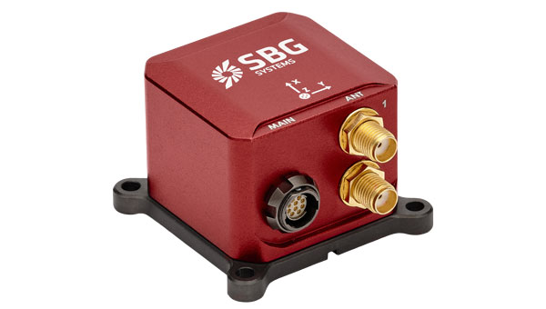
SBG Systems has unveiled its MEMS-based North-seeking inertial measurement unit (IMU) that operates independently of GNSS. According to the company, this launch lays the foundation for future products, such as attitude and heading reference systems (AHRS) and inertial navigation systems (INS), broadening the scope of MEMS-based navigation solutions.
The MEMS-based IMU can achieve a heading accuracy greater than 1° secant latitude without GNSS assistance. When integrated with GNSS and SBG Systems’ navigation algorithms, it can achieve INS heading accuracy greater than 0.01°.
The device features a true MEMS-based design with no moving parts, eliminating the need for carouseling mechanisms. This ensures enhanced durability and reliability across a wide range of operating environments.
Key features of this IMU include its compact size, low weight and minimal power consumption. Measuring 52 x 52 x 36 mm and weighing less than 150 g, it consumes only 2 watts of power. Designed for high-volume production, the device is well-suited for widespread adoption across industries. Additionally, its robust design offers long-term reliability in demanding conditions, and its ITAR-free status allows unrestricted global deployment.
SBG Systems has also developed new algorithms to enhance gyrocompass and INS alignment performance. These include a pure north-finding algorithm capable of rapid initialization in both static and dynamic conditions within one minute, as well as an advanced GNSS/INS fusion algorithm that delivers exceptional single-antenna heading accuracy even in low-dynamic environments.
It can be used for applications such as marine operations, autonomous systems and georeferencing. The IMU is particularly suited for subsea applications including remotely operated vehicles and autonomous underwater vehicles, as well as geospatial and marine surveying tasks requiring precise single-antenna heading accuracy.
The first off-the-shelf solutions are expected to be available by early 2026.
Unicore has introduced the UM981 series, a high-precision positioning module that integrates RTK and inertial navigation system (INS) technologies. The solution leverages GNSS and INS navigation to cater to applications in precision agriculture, surveying and mapping.
The module is compatible with all major navigation systems and frequencies, tracking signals from multiple systems simultaneously for enhanced performance even in challenging environments. Additionally, the UM981 series supports open Precise Point Positioning (PPP) services such as BDS-3 PPP-B2b, Galileo E6 HAS and QZSS L6 MADOCA-PPP, achieving 10 cm positioning accuracy with a convergence time of under 10 minutes, according to Unicore.
The UM981 series processes high-frequency GNSS and IMU data streams efficiently, offering RTCM data transmission at up to 20 Hz, single-point positioning and RTK at up to 50 Hz and integrated navigation data and IMU raw data at up to 100 Hz. These capabilities make it suitable for dynamic scenarios requiring high precision.
In precision agriculture, the UM981 module simplifies machinery auto-steering systems by enabling single-antenna positioning and attitude determination through advanced MEMS technology. At speeds above 1 km/h, it achieves heading accuracy better than 0.3° and roll/pitch measurements better than 0.2°, with accuracy improving as speed increases. The module supports CAN Bus communication and can be customized to work with the ISOBUS Protocol, eliminating the need for switching between interfaces during serial port communication.
For surveying and mapping applications, the UM981S variant delivers high-accuracy positioning and tilt measurement using GNSS and INS fusion algorithms. It eliminates traditional shake-to-start requirements with a walk-and-go feature that allows users to initialize tilt measurement simply by walking with the measurement pole. The module provides 2.5 cm accuracy within a 30° tilt range and supports measurements at larger angles up to 120°, making it suitable for complex environments such as building corners or areas under tree canopies.
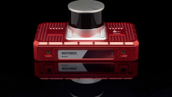
OxTS has released WayFinder, a new localization solution designed for use in GNSS-denied environments. The system combines a GNSS/INS system, onboard processor, lidar scanner and two cameras to enable accurate positioning in areas with limited satellite coverage, such as urban canyons and underground tunnels.
Precise localization data is crucial for various industries, including autonomous navigation, automotive testing and sensor data georeferencing. However, obtaining accurate positioning information in areas with weak or unavailable GNSS signals has been a persistent challenge. WayFinder is designed to operate with minimal setup, requiring only basic configuration before use. The system’s key feature is Lidar Boost, a new software technology that enhances GNSS/INS performance in environments with unreliable satellite signals.
Lidar Boost employs advanced algorithms to process data from the integrated Lidar scanner, compensating for missing or erroneous GNSS updates in real time. This allows WayFinder to maintain high-accuracy localization in areas with limited satellite coverage and ensure smooth transitions between GNSS-supported and GNSS-denied environments.
The system can be used across multiple sectors. In ports, it can provide precise localization for autonomous vehicles operating among stacked shipping containers. In mining, it can support navigation for both underground and surface vehicles. WayFinder also offers a solution for indoor automotive testing without the need for fixed infrastructure. Surveyors working in areas with intermittent GNSS coverage can also benefit from its positioning capabilities.
Read a roundup of recent products in the GNSS and inertial positioning industry from the March 2025 issue of GPS World magazine.
Surveying and Mapping
Photo: Eos Positioning Systems
New Eco-Friendly Carrying Case For Eos Positioning Systems’ receivers
The Skadi Gold, Skadi 300 and Skadi 200 GNSS receivers will now be shipped in a field-rugged carrying case made entirely from recycled materials. The case is designed to meet the demands of professionals who utilize GNSS technology in challenging environments. Its construction incorporates durable, eco-friendly materials that can withstand various field conditions, from remote wilderness areas to urban construction sites.
A key feature is its composition of 100% post-consumer recycled resin, which significantly reduces waste and promotes environmental sustainability, according to the company. It is specifically engineered to be shock-resistant and weatherproof.The case is provided as a standard inclusion with every purchase of the Skadi Gold, Skadi 300 or Skadi 200 GNSS receivers at no additional cost.
Multibeam Sonar Designed for bathymetric surveying
The Gemini 1200id is built on the same robust platform as the Gemini 720is multibeam sonar. The device features a 120° horizontal field of view, operating at both 720 kHz and 1,200 kHz acoustic frequencies.
The Gemini 1200id incorporates advanced noise reduction technology to significantly improve the attenuation of waterborne electrical noise to enhance imaging performance. An integrated speed-of-sound sensor ensures high positional accuracy of displayed targets, while CHIRP processing technology enhances target separation over extended ranges.
Compatibility with Tritech’s Genesis software package allows users to control multiple Tritech products from a single interface to streamline operations. The company has also made software development kits available for Windows and Linux operating systems to integrate into various platforms. The sonar’s design includes a custom-developed analog front-end solution with fully differential receiver channels, making it ideal for longer-range applications.
HiPer XRa is a GNSS receiver for surveying, mapping and construction applications. It can benefit a wide variety of users, including construction professionals, surveyors, geographic information systems (GIS) professionals, archeologists, engineering firms and more. The HiPer XR supports GPS, GLONASS, Galileo, BeiDou, IRNSS, QZSS and SBAS.
The new receiver has advanced Topcon Integrated Leveling Technology (TILT) compensation, featuring a calibration-free and magnetic interference-immune integrated IMU that provides up to 60° of tilt for precision measurements in challenging positions. It has signal integrity protection, anti-jamming and anti-spoofing capabilities. Through the myTopcon NOW! website, users can access online training materials, firmware updates and additional software resources.
Airborne Lidar System Ideal for coastline and river surveying
CoastalMapper is an airborne bathymetric lidar system for coastline and river surveying. The CoastalMapper can survey coastlines and rivers 250% faster than previous sensor models, according to Leica Geosystems.
It is suitable for various mapping applications, from assessing infrastructure resilience to monitoring river floods and conducting environmental investigations.
It features a high-performance bathymetric lidar module, a Leica TerrainMapper-3 topographic lidar and an imaging sensor, integrated into a compact and lightweight sensor head. This allows the CoastalMapper to capture up to 1 million bathymetric data points and 2 million topographic data points per second while providing high-resolution imagery with a 5-cm ground sampling distance at typical flying heights.
It integrates with Leica Geosystems’ airborne mapping workflows and offers cluster processing capabilities, allowing users to analyze large datasets and reduce the time from data collection to final deliverables. These outputs can include classified point clouds, digital terrain and surface models, and various imaging products.
Surveying Kit Streamlines base station and checkpoint setup
WingtraGROUND, a comprehensive survey kit, streamlines base station and checkpoint setup for on-site post-processing kinematic surveys with the WingtraONE Gen II, a vertical takeoff and landing UAV. The kit combines receivers, checkpoints and tools into a single, portable workflow.
The system integrates hardware components with a Wingtra tablet interface, which can help surveyors confirm correct receiver placement and avoid common errors associated with improper base station setup and inaccurate coordinates.
Wingtra receivers, equipped with Emlid Reach RS3 technology, provide accuracy within 2 cm, meeting high standards for aerial data validation. These receivers can also function independently for terrestrial surveys in real-time kinematic mode, including point collection and stakeout for various applications.
Galileo HAS-Enabled Receiver Offers positioning capabilities with 20 cm accuracy
The Geode GNS3H supports Galileo High Accuracy Service (HAS). It offers positioning capabilities with 20 cm accuracy worldwide without requiring additional infrastructure or subscriptions.
It is built to withstand tough conditions, making it ideal for demanding fieldwork. The device offers various accessories, including the Geode Grip, which combines the Geode with a data collection device of choice into a single handheld solution. A backpack strap kit and survey pole are also available to enhance mobility and flexibility in the field. The GNS3H can be used for surveying, agriculture, construction, forestry, mining and archaeology.
Expanded Mapping Portfolio 3D mapping technologies and more
Topcon Positioning Systems has become an authorized distributor of Pix4D’s photogrammetry software portfolio.
The partnership aims to enhance reality capture solutions across various industries, including surveying, mapping, utilities infrastructure, public safety, forensics, and architecture, engineering and construction.
The agreement streamlines the procurement process for end users by allowing them to access Pix4D’s advanced photogrammetry software solutions through Topcon’s global distribution network.
The GNSS real-time kinematic (RTK) 5 Click — a compact add-on board for high-precision positioning and navigation demands — features the UM980, an all-constellation multifrequency RTK positioning module from Unicore, with the advanced NebulasIV SoC for enhanced performance.
It supports Swift Navigation’s Skylark precise positioning service, multiple GNSS constellations and RTK positioning for centimeter-level accuracy. The board also features JamShield technology for robust performance in challenging environments, USB connectivity for easy configuration and visual status indicators for module status and GNSS signal reception.
It can be used for a variety of applications, including surveying and mapping, precision agriculture, UAVs, autonomous robots and autonomous driving.
Multi-Band GNSS Antenna Can operate in urban environments
Levity Series’ AHP24510 (L1/L2/L-Band) and AHP54510 (L1/L5/L-Band) directional patch antennas are designed to receive signals from GPS, Galileo, GLONASS and BeiDou satellite constellations.
These antennas offer faster and more accurate signal acquisition and lock, specifically in urban environments. The L-Band capability allows compatibility with high-precision GNSS correction services. The multi-band antennas offer integral redundancy to minimize satellite security blind spots and reduce energy consumption due to faster acquisition, requiring less system uptime to save power.
The Levity Series active antennas feature a 45 mm x 45 mm x 10 mm wide-band, dual-stacked patch design with a dual-feed, low noise amplifier, providing 28 dB to 29 dB gain and filtering. They operate with a maximum antenna VSWR of 1-to-1 from 1,207 MHz to 1,603 MHz, and the passive antenna efficiency ranges from 39.93% to 68.51% in the L1 band. These antennas use right-hand circular polarization to mitigate multi-path interference.
The Levity Series includes other multi-band products for high-precision applications, such as the HP24510A and HP54510A stacked-patch passive components, and the TFM.120A surface-mount front-end module, which covers the full multi-band GNSS spectrum including L-band. These antennas are suitable for various applications, including wearables, transportation, robotics, precision agriculture and autonomous vehicles.
The M9PLUS-HCT-A-SMA is an active multi-frequency GNSS antenna designed for high-accuracy applications. It supports L1/L2/L5 GPS, Galileo, Beidou and GLONASS bands, as well as L-band correction services. The antenna utilizes Maxtena’s proprietary Helicore technology, which offers advanced pattern control, polarization purity and efficiency in a compact form factor.
It integrates a pre-filter specifically engineered to mitigate LTE interference. This is crucial for maintaining signal integrity in environments with dense mobile communication networks, where LTE signals can overlap with GNSS frequencies. The pre-filter can effectively block out-of-band LTE signals, reducing intermodulation risks and ensuring clear GNSS signal reception.
The M9PLUS-HCT-A-SMA is built with rugged, IP67 automotive-grade components and includes an integrated SMA connector. It also features an O-ring for enhanced environmental sealing. Weighing only 24 grams, the antenna is ground plane-independent, making it versatile for various installations. It is particularly well-suited for GIS and RTK applications where high accuracy and reliability are crucial.
The MostaTech G321M is a three-axis fiber optic gyroscope (FOG) that offers high-precision navigation and orientation measurement capabilities. This advanced sensor features a data rate of 8 kHz.
Key features of the G321M include an input range of 400° per second, a bias RMS of 1° per hour and an angular random walk of 0.025 °/√h. Additionally, it has a power consumption of 2 W and an initialization time of 1 second. The G321M is designed with a compact form factor, making it suitable for various applications where size and weight are critical factors.
It is ideal for UAVs, robotics, borehole surveys, image stabilization, gimbal stabilization and underwater vehicles.
High-Precision Lidar Designed for precision applications
The TV1 Lite and the TV1 UAV systems are designed for various precision applications, such as mapping and data collection.
The TV1 Lite features TrueNav technology, a Hesai 32-channel laser scanner and a FLIR 5MP global shutter camera with a 90° field of view. It also includes one year of TV1 Lite Annual Processing with support and maintenance.
TV1 offers customization options, allowing users to choose from 26 MP, 45 MP or 61 MP cameras and various Trajectory Correction Service options.
Flight Control System With autopilot functionality
The Prism Supervisor software combines UAV autopilot flight control systems with AI-based observations processed in real time, aiming to enhance UAV operations.
The system provides a programming framework and software development kit for users to create custom mission scenarios. During flight, Prism Supervisor can adapt its autopilot functionality in real time, generating mission segments and flight plans as needed.
The software features a user-friendly graphic interface for mission planning, real-time visualization and execution. It supports Windows, Linux, macOS, iOS and Android.
Remote ID Receiver Enhances airspace awareness and UAV safety
RIDER is designed to enhance situational awareness by providing real-time detection of UAV activity in sensitive areas. It also seeks to provide a clear visibility of surrounding UAV operations to help avoid potential collisions and ensure safer flight experiences.
The device features a built-in industrial chip SIM that provides global coverage through LTE-M and NB-IoT, ensuring connectivity in various environments.
It operates effectively within a temperature range of -20 °C to +60 °C and is rated IP54 for dust and water resistance. The device complies with ASTM F3411-22A and ASD-STAN EN 4709-002 standards, making it suitable for regulatory environments.
The RIDER can detect signals from up to 5 km with its default antennas and up to 10 km when using an optional high-performance antenna. It is equipped with an internal cellular and Bluetooth antenna, along with an integrated GNSS antenna that provides precise positioning and timestamping capabilities. It supports multiple GNSS frequencies and utilizes Bluetooth and Wi-Fi technologies for Remote ID communications.
Streamlined BVLOS Operations For a variety of applications
The Sentaero 6 UAV is designed for advanced over-the-horizon operations beyond visual line of sight (OTH-BVLOS). It features built-in AI and machine learning capabilities for real-time data processing. The system can be used for surveying, mapping, inspection, asset monitoring and more.
Engineered to streamline operations, the Sentaero 6 offers more accurate and up-to-date intelligence on assets. Its onboard computer can processes data mid-flight.
Future developments will include swarm operations, enabling one human to control multiple UAVs simultaneously; fully remote operations and higher safety standards, such as a parachute for urban missions, according to Censys Technologies.
SBG Systems has significantly updated its Ellipse series sensors, incorporating the latest World Magnetic Model (WMM) to enhance accuracy and reliability in navigation applications. This upgrade is available for all Ellipse sensors, including first-generation models.
Designed for unmanned systems such as UAVs, UGVs and marine platforms, the Ellipse series comprises compact, high-precision inertial sensors. These devices feature built-in three-axis magnetometers that measure Earth’s magnetic field, crucial for accurate heading and positioning data.
Updated every five years, the WMM is a globally recognized mathematical representation of Earth’s magnetic field. The latest version, released in December 2024, ensures precise heading and positioning corrections to account for ongoing geomagnetic changes.
NDAA-Compliant UAV Now integrated with ArcGIS Flight
Esri now supports the Astro Max UAV in its ArcGIS Flight application. The Astro Max is the first Blue UAS-cleared and NDAA-compliant UAV to integrate with Esri’s platform.
The Astro Max, developed by Esri partner Freefly Systems, adheres to the security and performance standards set by the National Defense Authorization Act and the Defense Innovation Unit’s Blue UAS initiative. This industrial UAV is designed to enhance the capabilities of government and enterprise users utilizing ArcGIS Flight.
Autonomous Swarm Control Controls various autonomous platforms
The Autonomous Multi-Domain Operations Resiliency Platform for Heterogeneous Unmanned Swarms (AMORPHOUS) software features a single-user interface to operate thousands of autonomous assets simultaneously. Designed with an open architecture, this software enables the U.S. and allied militaries to control a mix of uncrewed platforms, payloads and systems.
AMORPHOUS includes an intuitive and distributed command-and-control interface to give operators the flexibility to conduct a wider array of intricate military missions. This collaborative autonomy at scale will provide warfighters with a decisive overmatch capability.
L3Harris is developing prototypes using the AMORPHOUS architecture on contracts for the U.S. Army and the Defense Innovation Unit. AMORPHOUS has demonstrated flexibility and interoperability by controlling multiple, separate assets across multiple vehicle types operating in different domains during government-managed tests.
AMORPHOUS supports decentralized decision-making, which enables individual, uncrewed assets to perform tasks autonomously and make real-time tactical decisions inside the network.
Advanced Counter-UAV Radar Multi-console radar control and display system
Cambridge Pixel has developed a radar control and display system for Weibel Scientific’s XENTA surveillance radar, which is designed for modern air defense and counter-unmanned aerial systems (C-UAS) applications.
The XENTA radar includes 3D target tracking, continuous target illumination and synthetic receiver beamforming. It is available in two configurations: the XENTA-M for short-range air defense and the XENTA-C for C-UAS operations.
The system is designed to work seamlessly with third-party command-and-control systems, enhancing operational efficiency.
Cambridge Pixel’s library of radar processing software allows users to develop a tailored radar controller specific to the XENTA radar’s requirements. Enhancements were made to existing functionalities, such as improved MIL-STD-2525 overlay graphics and support for dual-redundant operator consoles.
The XENTA radar system can detect small UAVs at distances exceeding 7 km and classify them beyond 5 km. This capability makes it suitable for various applications, including airport security, border control, critical infrastructure protection and event security.
The Pelican 2 agricultural spray UAV has an expanded 300-liter payload capacity and can cover up to 5.3 ha/hr.
It incorporates several technological enhancements designed to meet the demands of agriculture applications. The aircraft features an upgraded four-motor electric propulsion system, a wider 18-m spray swath and advanced lidar and radar systems for fully autonomous day-and-night spraying. These improvements aim to increase efficiency and precision in aerial application while reducing operational costs for farmers.
The Pelican 2’s airframe and structural components are constructed from carbon fiber composites, corrosion-resistant metallic components and 3D-printed assemblies.
SBG Systems has released the New Ellipse, a firmware upgrade for the Ellipse product line. The system can now be used as an attitude and heading reference system or inertial navigation system.
Powered by the latest-generation sensor fusion algorithm, the New Ellipse is designed to enhance navigation, attitude, and heave performance for stable and accurate positioning even in high-dynamics environments and challenging conditions.
Additionally, it introduces advanced GNSS-denied capabilities, featuring newly integrated flags that trigger when GNSS jamming or spoofing threats are detected. This allows users to reject or re-enable external sensors — such as GNSS — without resetting the filter. It seeks to provide users with enhanced visibility and control over how the individual system responds to these events, allowing for more precise adjustments in challenging environments.
The New Ellipse offers several new features that simplify system integration. It now supports seamless configuration and interfacing via a robust RESTful API. The user-friendly interface allows for fast and flexible configuration using simple command lines, enabling users to tailor the Ellipse to their specific needs and applications. The firmware upgrade is now available at no additional cost to all users of compatible hardware (v3.x).
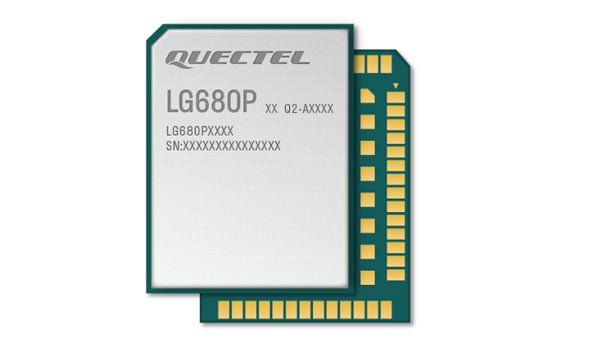
Quectel Wireless Solutions has introduced the LG680P, a multi-constellation, quad-band GNSS module designed to provide high-precision positioning for applications such as precision agriculture, intelligent robotics and surveying. It has a multi-constellation capability for accurate and reliable positioning.
The LG680P supports concurrent reception of L1, L2 and L5 frequency bands, which seeks to improve signal quality and precision. Additionally, it is equipped to support advanced signals such as Galileo E6, QZSS L6 and BDS B2b for Precise Point Positioning (PPP) technology. This feature enables high-precision accuracy without requiring local or broadband connectivity. The module’s ability to integrate these technologies makes it suitable for demanding environments where reliable positioning is critical.
The module achieves horizontal accuracy of up to 0.8 cm + 1 ppm, even in challenging urban environments. It has been tested with dual-band corrections to ensure backward compatibility with existing systems while supporting quad-band corrections for optimal performance. This backward compatibility allows the LG680P to replace older dual-band systems seamlessly, offering enhanced precision and futureproofing without requiring immediate infrastructure upgrades.
Features and Applications
To maintain signal integrity in complex electromagnetic environments, the LG680P incorporates professional-grade anti-jamming and interference detection algorithms. It’s built-in NIC anti-jamming technology suppresses multiple narrow-band interferences, improving signal reception and stability. These features make the module highly robust in environments with significant electromagnetic interference.
The LG680P is compact, with a 22 mm by 17 mm footprint that adheres to a widely used industry form factor. It supports multiple interfaces such as UART, SPI, I2C, and CAN, ensuring seamless integration into diverse platforms. The module also supports external active antennas to optimize signal reception and enhance positioning accuracy.
The LG680P is suited for various applications, including autonomous lawnmowers, delivery robots, surveying equipment, and precision agriculture tools. Quectel also offers two external full-band GNSS antennas compatible with the module: the YEGR001W8AH geodetic GNSS antenna with versatile mounting options and the YEGD006U1A compact patch antenna designed for high-precision positioning.
Hexagon | NovAtel has entered into a Memorandum of Understanding (MOU) with GPR, Inc. to integrate GPR’s WaveSense ground-penetrating radar sensors into NovAtel’s SPAN GNSS/INS solution. This collaboration aims to explore the integration of NovAtel’s SPAN system with GPR’s subsurface mapping technology, enhancing positioning solutions for applications requiring high reliability and centimeter-level accuracy, such as autonomous systems, mining and other mission-critical operations.
NovAtel’s SPAN GNSS+INS technology has historically provided reliable position, velocity and attitude (PVA) data by combining GNSS signals with IMU data. This approach ensures continuous accuracy during short GNSS interruptions caused by environmental factors like foliage or buildings. By incorporating WaveSense’s ground-penetrating radar as an additional input, the system can maintain accurate PVA solutions even during extended GNSS outages due to obstructions, signal interference, or jamming. This integration is particularly beneficial in GNSS-denied environments or areas lacking clear surface structures.
WaveSense technology operates by scanning up to 10 ft below the ground to map unique subterranean features. These stable underground patterns serve as a reliable reference for navigation, unaffected by adverse weather conditions such as snow, rain or fog. The combination of SPAN and WaveSense technologies is expected to significantly enhance navigation accuracy and reliability in challenging environments, according to the company.
Under the terms of the MOU, NovAtel and GPR will collaborate on specific use cases to demonstrate the combined capabilities of SPAN and WaveSense in demanding applications. Following these demonstrations, the partnership may advance toward a full product definition and supply agreement, according to the companies.
In partnership with the European Space Agency (ESA), EnSilica, a maker of mixed-signal application-specific integrated circuits, will design and develop a key silicon component to enable resilient multi-band global navigation satellite system (GNSS) capabilities. These are vital to ensuring the world’s critical infrastructure and services remain robust and secure in the face of evolving global threats, according to the company.
The ESA NAVISP Element 2 program helps to increase the competitiveness of participating European states in the global market for satellite navigation and enables these countries to be positioned to capitalize on emerging market opportunities across positioning, navigation and timing (PNT) technologies and services.
“As we and our infrastructure become ever more dependent on PNT services in everyday life, it is important to have highly integrated, resilient and precise technology sourced in Europe and the UK,” said Paul Morris, vice president of RF and communications business unit at EnSilica. “This collaboration will allow us to accelerate such technology, starting with a next-generation radio design enabling our partners to focus on integrating their custom algorithms.”
EnSilica has a growing satellite communications market footprint and is working with support from ESA and the UK Space Agency (UKSA), with the latter organization awarding the company £10.38 million ($12.8 million) in February 2025 for a development project under its Connectivity in Low-Earth Orbit program. Part of the company’s expertise is in architecting and implementing systems-on-chip with high-performance RF, including mmWave, and complex baseband processing.
Ian Lankshear, CEO of EnSilica, added, “I am extremely proud of our team to have been secured this agreement under the ESA NAVISP Element 2. This project will enable us to further enhance GNSS technology and continue to develop commercial solutions that are critical for resilient and reliable satellite navigation. We are grateful for the ongoing support from ESA and the UKSA, and we continue to focus on PNT and the broader satellite communications market as a key growth driver of our business.”
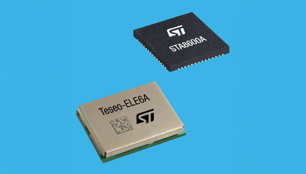
STMicroelectronics has unveiled the Teseo VI family of GNSS receivers. The new receivers integrate multi-constellation and quad-band signal processing on a single chip, achieving centimeter-level accuracy for various applications.
The Teseo VI family includes the STA8600A and STA8610A models, featuring dual independent Arm Cortex-M7 processing cores. These receivers are designed for automotive applications such as advanced driver assistance systems (ADAS) and autonomous driving, as well as industrial uses including asset tracking, mobile robots and precision agriculture.
The receivers integrate all necessary system elements for centimeter accuracy into one die, supporting simultaneous multi-constellation and quad-band operations. This seeks to simplify product development and enhance reliability in challenging conditions, such as urban canyons.
The Teseo VI+ variant can host enhanced positioning engines developed by third-party companies, providing real-time kinematics for centimeter position accuracy. The Teseo APP2 STA9200MA operates dual cores in lockstep, offering hardware redundancy for applications requiring ISO 26262 ASIL-B functional safety compliance12.
STMicroelectronics’ RF architecture and GNSS baseband design provide quad-band GNSS support (L1, L2, L5 and E6) with the ability to acquire and track only L5, improving performance in difficult conditions.
\All variants include hardware cybersecurity features such as secure boot, over-the-air firmware updates, and output-data protection. The devices comply with UNECE R155 and ISO 21434 specifications for cybersecurity by design. Two new GNSS automotive modules, the Teseo-VIC6A and Teseo-ELE6A, have been introduced to simplify integration of Teseo VI/VI+ ICs on customer platforms and ensure optimal performance.