Tag: OEM

  • MIKROE unveils Click Board for precision applications

    MIKROE unveils Click Board for precision applications

    MIKROE has unveiled the GNSS RTK 5 Click, a compact add-on board for high-precision positioning and navigation demands. It features the UM980, an all-constellation multifrequency RTK positioning module from Unicore, with the advanced NebulasIV SoC for enhanced performance.

    It supports Swift Navigation’s Skylark precise positioning service, multiple GNSS constellations, and RTK positioning for centimeter-level accuracy. The board also features JamShield technology for robust performance in challenging environments, USB connectivity for easy configuration and visual status indicators for module status and GNSS signal reception.

    It can be used for a variety of applications, including surveying and mapping, precision agriculture, UAVs, autonomous robots and autonomous driving.

  • Northrop Grumman advances airborne navigation for US Navy

    Northrop Grumman advances airborne navigation for US Navy

    The U.S. Navy has selected Northrop Grumman to advance its airborne navigation capabilities by integrating Northrop Grumman’s LN-251M, the upgrade of the LN-251 inertial navigation system (INS)/GPS. This new system incorporates M-Code technology, which provides an encrypted, military-specific signal with improved resistance to jamming, offering better protection against potential threats.

    According to the company, the LN-251M represents a significant advancement in naval aircraft navigation, being the first M-Code navigation system designed for this purpose. The M-code technology offers increased robustness against GPS signal degradation, which allows pilots to operate more effectively in areas where GPS signals may be compromised or unavailable.

    The LN-251 series is designed to integrate seamlessly with existing aircraft navigation systems and is compatible with future software and GPS modernization upgrades.

  • Advanced Navigation to develop INS for Gilmour Space rocket launches

    Advanced Navigation to develop INS for Gilmour Space rocket launches

    Advanced Navigation has secured grant funding from the Australian Space Agency through the Moon to Mars Initiative Grant. This funding will expedite the development of a space-grade high-shock inertial navigation system (INS) designed to endure extreme conditions during rocket launches.

    The INS will support Gilmour Space Technologies, an Australian launch services company, in the development and launch of Eris Rockets and Elara Satellite platforms to low-Earth orbits (LEO). This collaboration aims to enhance Australia’s sovereign aerospace capabilities and contribute to the growing space industry.

    The development of this advanced INS presents significant engineering challenges due to the harsh conditions experienced during rocket launches. From lift-off to payload deployment, every phase of a rocket’s journey requires precise engineering and seamless coordination. All electronic and fiber-optic components must be capable of withstanding intense shock, vibration, shifting gravity, payload impact and extreme temperature fluctuations.

    The onboard INS consists of a plethora of high-end sensors, including accelerometers and gyroscopes, sensitive enough to detect the smallest change in noise and vibration. To ensure accurate and reliable performance, these delicate components must be shielded from the extreme forces experienced during launch. One solution is the integration of a high-shock enclosure — a protective barrier encircling the INS housing. This enclosure acts as a cushion between the system and the surrounding structure, absorbing and redistributing intense g-forces from engine ignitions and launch vibrations. By dampening these shocks, the enclosure prevents disruptive forces from reaching the sensors, preserving their precision in the harshest conditions.

  • Taoglas launches multi-band GNSS antennas

    Taoglas launches multi-band GNSS antennas

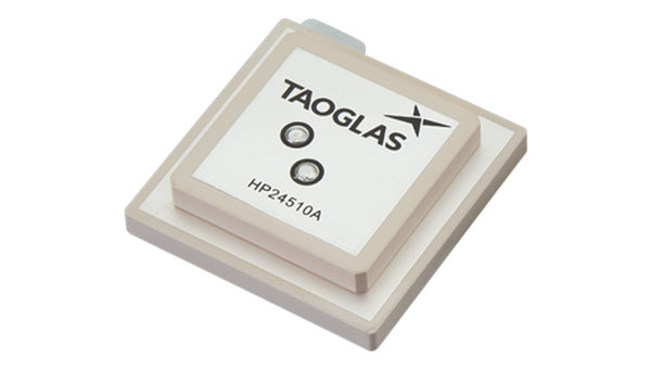
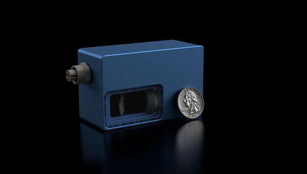
    Taoglas has released a new family of active, multi-band GNSS antennas. Levity Series’ AHP24510 (L1/L2/L-Band) and AHP54510 (L1/L5/L-Band) directional patch antennas are designed for GPS, Galileo, GLONASS and BeiDou satellite constellations.

    These antennas offer improved performance through triangulation across multiple satellites, offering faster and more accurate signal acquisition and lock, specifically in urban environments. The L-Band capability allows compatibility with high-precision GNSS correction services, potentially achieving positioning accuracy better than 200 cm.

    The multi-band antennas seek to offer integral redundancy to minimize satellite security blind spots and reduce energy consumption due to faster acquisition requiring less system uptime to save power.

    The Levity Series active antennas feature a 45 mm x 45 mm x 10 mm wide-band, dual-stacked patch design with a dual-feed, low noise amplifier, providing 28 dB to 29 dB gain and filtering. They operate with a maximum antenna VSWR of 1-to-1 from 1,207 MHz to 1,603 MHz, and the passive antenna efficiency ranges from 39.93% to 68.51% in the L1 band. These antennas use right-hand circular polarization to mitigate multi-path interference.

    The Levity Series includes other multi-band products for high-precision applications, such as the HP24510A and HP54510A stacked-patch passive components, and the TFM.120A surface-mount front-end module, which covers the full multi-band GNSS spectrum including L-Band.

    These antennas are suitable for various applications, including wearables, transportation, robotics, precision agriculture and autonomous vehicles.

  • Savvy Navvy launches navigation platform for marine OEMs

    Savvy Navvy launches navigation platform for marine OEMs

    Savvy Navvy has released Savvy Integrated, a comprehensive hardware and software integration platform specifically designed to provide advanced navigation solutions for original equipment manufacturers (OEMs) in the marine industry. This solution combines digital charting technology with hardware integration capabilities, addressing critical navigation challenges for boat manufacturers.

    The Savvy Integrated platform provides OEMs with a navigation solution featuring a comprehensive digital marine chart with real-time geographical data and seamless integration with multifunction displays. The platform, which is compatible with a range of marine system architectures, offers extensive depth mapping and navigation details, as well as support for various types and configurations of vessels.

  • EnSilica receives funding from UK Space Agency for satellite broadband terminal chips

    EnSilica receives funding from UK Space Agency for satellite broadband terminal chips

    Logo: EnSilica
    Logo: EnSilica

    EnSilica, a chip maker of mixed-signal application-specific integrated circuits (ASICs), has been awarded funding from the UK Space Agency under its Connectivity in Low-Earth Orbit (C-LEO) program. Following a competitive selection process, EnSilica has been awarded £10.38 million ($12.8 million) throughout the next three years for a development project pioneered by EnSilica.

    “This is a great opportunity to accelerate our chipset development, enabling us to extend our portfolio of chips for the satellite broadband market with a focus on providing a complete solution for user terminals while reducing cost and power,“ said Paul Morris, EnSilica vice president of RF and communications business unit.

    EnSilica provided its application with supporting letters of interest from potential lead customers to develop a family of semiconductor chips to support future generations of mass market satellite broadband user terminals. According to the company, the terminals will be capable of connecting with various satellite constellations and will leverage advanced semiconductor technology. In addition, the project will provide a resilient source of chips, which will be independent and not tied to specific satellite service operators.

    The UK Space Agency’s C-LEO program was launched in 2024 and is designed to ensure that the UK space sector remains competitive in the rapidly evolving global market for low-earth orbit constellations. With a total funding pool of up to £160 million ($198 million) available over the next four years, the C-LEO program supports the development of smarter satellites, enhanced hardware, artificial intelligence-driven data delivery and improved inter-satellite connections.

    This new project builds on EnSilica’s long history of collaboration with the UK Space Agency and the European Space Agency, alongside other key satellite communications partnerships and the company’s own investment in the technology.

  • Microchip Technology unveils low-noise chip-scale atomic clock

    Microchip Technology unveils low-noise chip-scale atomic clock

    Microchip Technology has introduced its second-generation Low-Noise Chip-Scale Atomic Clock (LN-CSAC), model SA65-LN. It features a lower profile height and operates in a wider temperature range, providing low-phase noise and atomic clock stability in challenging environments.

    Chip-scale atomic clocks (CSACs) offer precise and stable timing in situations where traditional atomic clocks are impractical due to size or power constraints or where satellite-based references may be unreliable.

    The SA65-LN, featuring Microchip’s Evacuated Miniature Crystal Oscillator (EMXO) technology, offers significant advancements in oscillator design. With a profile height of less than half an inch, power consumption under 295 mW, and an operating temperature range from −40°C to +80°C, this compact device delivers impressive performance. These enhanced specifications make the SA65-LN an ideal choice for a wide array of aerospace and defense applications. It is particularly well-suited for use in mobile radar systems, dismounted radios, IED jamming equipment, autonomous sensor networks, and unmanned vehicles, where size, power efficiency, and temperature resilience are crucial factors.

    The LN-CSAC combines a crystal oscillator and an atomic clock in a single device, offering a low-phase noise of 10 Hz < −120 dBc/Hz, an Allan Deviation (ADEV) stability of < 1E-11 at 1-second averaging time, and an initial accuracy of ±0.5 ppb. The LN-CSAC also demonstrates frequency stability with a < 0.9 ppb/mo drift and maximum temperature-induced errors of < ±0.3ppb. These features contribute to high-quality signal integrity and atomic-level accuracy, potentially extending mission durations and reducing maintenance requirements.

  • ANELLO Photonics unveils Maritime inertial navigation system

    ANELLO Photonics unveils Maritime inertial navigation system

    ANELLO Photonics has introduced its Maritime inertial navigation system (INS). The system integrates ANELLO’s Silicon Photonic Optical Gyroscope (SiPhOG) technology with an advanced sensor fusion engine, offering high-precision navigation for autonomous surface and underwater vessels.

    The ANELLO Maritime INS combines optical gyroscope performance and silicon photonics technology, resulting in a compact, low-power consumption device designed for GPS-challenged environments. Its capabilities include reference-grade position, velocity and attitude data output at 100Hz, and a high-precision three-axis SiPhOG with less than 0.5°/hr unaided heading drift.

    This system incorporates dual triple-frequency GNSS receivers with static heading capability and an AI-powered sensor fusion engine with GNSS spoofing detection. The INS provides accurate dead reckoning and is designed to withstand harsh maritime conditions, being waterproof and resistant to corrosion, salt spray, and chemicals. The system’s applications extend beyond maritime use, with potential benefits for industries such as construction, agriculture, robotics and defense.

  • Hexagon to acquire Septentrio

    Hexagon to acquire Septentrio

    Hexagon has entered an agreement to acquire Septentrio, a move aimed at advancing resilient assured positioning solutions across various industries.

    The integration of Septentrio’s GNSS platform with Hexagon‘s positioning technologies aims to enhance accessibility to high-accuracy positioning solutions with reduced size, weight and power requirements. This acquisition is expected to impact various sectors, including robotics, UAVs and other autonomous systems, by providing improved positioning capabilities. 

    According to the company, Septentrio, based in Leuven, Belgium, employs approximately 150 people and is projected to generate over 50 million euros in revenue in 2024. The transaction, subject to regulatory approvals, is expected to be completed in the first half of 2025.

    Following the acquisition, Septentrio will continue its current business model, supplying GNSS technology to its existing OEM users. The company will be incorporated into Hexagon’s Autonomous Solutions division. It is anticipated to have significant implications for the positioning industry, potentially setting new standards for accuracy, resilience, and scalability in positioning technologies.

  • Voyant Photonics introduces Carbon lidar sensor

    Voyant Photonics introduces Carbon lidar sensor

    Voyant Photonics has introduced the Carbon frequency modulated continuous wave (FMCW) lidar sensor. It features lidar on a chip with solid-state beam steering integrated into a fingernail-sized silicon photonic chip. The Carbon sensor offers high-resolution imaging with millimeter precision and object detection capabilities up to 200 m.

     FMCW technology enables instant velocity measurement at each point, in addition to distance, reflectivity and intensity data. This 4D capability allows for high-fidelity point cloud data generation, providing a real-time view of the environment up to 20 times per second, according to Voyant Photonics.

    The sensor’s performance is notable in various environmental conditions. It can operate effectively through dust, fog, rain, and snow and is immune to sunlight interference, particularly during sunrise and sunset. Additionally, it is not affected by highly reflective objects such as street signs, traffic cones and safety vests.

    The Carbon sensor seeks to enhance machine perception capabilities across various industries, including industrial automation, robotics and security applications. Its software-defined lidar feature allows users to modify the frame rate and adjust the field of view during operation.

  • u-blox unveils GNSS chip for wearable devices

    u-blox unveils GNSS chip for wearable devices

    u-blox has launched the UBX-M10150-CC, a GNSS chip designed for wearable devices. It offers advancements in size, power efficiency and performance for battery-powered devices.

    The chip measures 2.39 x 2.39 x 0.55 mm, making it suitable for integration into small wearable devices such as sports watches and smartwatches — it also includes a mode specifically designed for open water swimming. The UBX-M10150-CC utilizes low energy accurate positioning technology, which achieves power consumption as low as 10mW. This technology, combined with smart adaptation to signal conditions, allows for a 50% reduction in power consumption compared to previous M10 chips, according to u-blox.

    It incorporates multipath mitigation technology, which enhances position accuracy, particularly in urban environments where signal reflections are common. This feature can be beneficial for maintaining accurate tracking in challenging signal conditions, u-blox said.

  • Hexagon | NovAtel introduces anti-jamming solution

    Hexagon | NovAtel introduces anti-jamming solution

    Hexagon | NovAtel has released its lowest size, weight and power (SWaP) GNSS anti-jamming technology (GAJT), the GAJT-310. The GAJT line is a battle-proven solution for assured positioning, navigation and timing (A-PNT) designed to protect against hostile radio frequency interference for land, air and sea applications.  

    The new GAJT-310 features advanced anti-jam technology with minimal latency within a compact device. The reduced latency allows the GAJT-310 to protect signals immediately with no additional setup. It can be either an integrated enclosure or a federated option with a separate electronics card and controlled reception pattern antenna (CRPA). The device offers enhanced protection for GNSS signals on both L1 and L2 bands. The GAJT-310’s commercially exportable technology makes it accessible worldwide, allowing for broader implementation across various industries and regions.

    “We’ve taken everything we learned from the successful in-theatre deployment of the GAJT-710 and GAJT-410 for NATO forces worldwide and built it into the GAJT-310,” stated Neil Gerein, vice president of product, aerospace and defense at Hexagon’s Autonomy & Positioning division. “Regarding assured positioning, navigation and timing, we believe every platform in any industry should be protected.”