PlanetiQ has signed a contract with Antrix Corporation Limited, the commercial arm of the Indian Space Research Organization (ISRO), for the launch of PlanetiQ’s first two weather satellites on a Polar Satellite Launch Vehicle (PSLV) during the fourth quarter of 2016.
Ten more satellites are planned for launch in 2017 to complete an initial set of 12 satellites that will dramatically improve global weather forecasting, climate monitoring and space weather prediction, and enable advanced analytics for numerous industries worldwide.
The ISRO’s PSLV is among the world’s most reliable launch vehicles with 30 consecutive successful flights. It has launched 51 satellites for international customers from 20 countries, in addition to 33 Indian national satellites.
“The stellar track record of the PSLV combined with our seven-year satellite design life provides the reliability and data continuity not just desired, but required by the operational weather forecast community,” said Chris McCormick, Chairman and CEO of PlanetiQ. “Within days after launch, we will validate and start delivering high-quality data and services to our customers.”
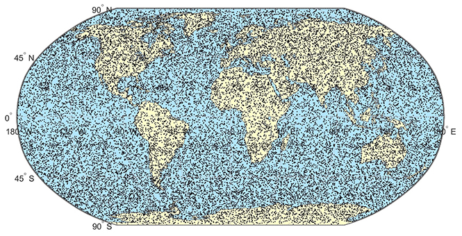
24 hours of data from 12 PlanetiQ satellites = ~34,000 occultations/day.
Each of PlanetiQ’s 10-kilogram microsatellites will fly PlanetiQ’s Pyxis-RO sensor, an advanced satellite weather sensor in a small package that can penetrate through clouds and storms down to the Earth’s surface. Pyxis-RO uses a technique called radio occultation to track the bending of GPS and other signals as they travel through Earth’s atmosphere, and then converts the bending angle into high-precision measurements of global temperature, pressure and water vapor in the atmosphere, and electron density in the ionosphere.
Pyxis-RO quadruples the data collection capability of radio occultation sensors on orbit today by tracking signals from all four major satellite navigation systems — GPS, Galileo, Beidou and GLONASS. With 12 satellites on orbit, PlanetiQ will collect 34,000 occultations per day, evenly distributed around the globe with high-density sampling over both land and water.
Each occultation is a vertical profile of atmospheric data with high vertical resolution, comprised of measurements less than every 200 meters from the Earth’s surface up into the ionosphere. The data is similar to that collected by weather balloons, but more accurate, more frequent and on a global scale.
“The world today lacks sufficient data to feed into weather models, especially the detailed vertical data that is critical to storm prediction. That’s why we see inaccurate or ambiguous forecasts for storms like Hurricane Joaquin, which can put numerous lives at risk and cost businesses millions of dollars due to inadequate preparation or risk management measures,” McCormick said. “Capturing the detailed vertical structure of the atmosphere from pole to pole, especially over the currently under-sampled oceans, is the missing link to improving forecasts of high-impact weather.”
SBG Systems has moved its United States headquarters office from Chicago, Illinois, to Huntington Beach, California.
SBG Systems is a supplier of miniature, high-performance and innovative motion sensing solutions. SBG Systems headquarters are based in Rueil-Malmaison, France.
Its California office has an additional 10,000 square feet. “We will be able to offer better delivery times, more convenient meeting facilities to meet our customers, and more space to allow our U.S team to keep growing,” the company stated in a press release. “The location allows more proximity with our customers in this highly economically dynamic area.”
New address and contact information:
SBG Systems North America, Inc.
5932 Bolsa Avenue, Suite #103
Huntington Beach, CA 92649
United States
ABI Research’s competitive analysis evaluates GNSS IC vendors across innovation and implementation parameters
The GNSS market is slowly shifting in new directions, according to ABI Research. While the smartphone market continues to grow, new opportunities are also emerging in automotive, insurance, wearables, unmanned aerial vehicles (UAVs) and the Internet of Things (IoT).
Overall, the GNSS market is forecast to continue to grow strongly, with ubiquitous location and market-specific IC design as key differentiators.
In its latest competitive analysis of GNSS IC vendors, ABI Research evaluates a variety of innovation and implementation parameters to determine emerging competitive threats and technologies, the companies best positioned for success and those in danger of losing out.
Unchanged for the past three years, the market’s two top IC vendors remain Qualcomm and Broadcom, soon to be acquired by Avago. Both companies continually illustrate the ability to lead the way on cutting-edge innovation, which in turn drives their dominant market-share position, ABI Research said.
Beyond just GNSS, both companies also offer comprehensive location technology platforms in HULA (Broadcom) and Izat (Qualcomm), which will enable smartphone OEMs to begin offering ubiquitous location in 2016. Qualcomm’s work on LED/VLC and LTE Direct illustrates the gap that now exists between it and pure-play GNSS IC vendors.
u-blox, a well-established GNSS IC company, has shown continuous growth each year by implementing new technologies and making acquisitions, culminating in its first ever third place ranking, ABI Research said. The company continues to lead the way in its core markets, while also expanding into the emerging IoT space.
“The big surprise this year has been MediaTek dropping to fourth place,” said Patrick Connolly, principal analyst at ABI Research. “This is primarily due to a lack of new GNSS or indoor location products. However, this did not affect its IC market share, or its ability to win an important GNSS IC win with Fitbit in wearables. MediaTek has a history of delivering when its customers need new innovation. As a result, ABI Research expects new product announcements from the company in 2016, especially around indoor location.”
Ranking fifth, STMicroelectronics is seeing customers migrate to its TESEO III platform. Its modular, high-performance approach should also enable it to move beyond its traditional markets of automotive and recreational/fitness, especially as it has begun to leverage the company’s expertise in sensor fusion.
As new opportunities for GNSS continue to develop in markets such as wearables, IoT, personal tracking and UAVs, there will also be a number of new or emerging companies looking to claim a share in the stakes. Analysis findings point to the Chinese regional market as one such area that has potential to demonstrate strong growth trends in future years.
“There’s big opportunity for emerging Chinese start-ups, such as CEC Huada, to meet new, indigenous, market demand over the next 10 years, while also working their way toward becoming major international competitors,” concluded Connolly. “Additionally, Galileo Satellite Navigation, an emerging company focused in software GPS, is reporting impressive results in trials. As consumer electronics start supporting software GPS, it will be interesting to watch whether or not it can achieve volume shipments in 2016.”
These findings are part of ABI Research’s Location Devices Service, which includes research reports, market data, insights and competitive assessments.
Galileo Satellite Navigation Ltd. (GSN), an Israeli startup, is demonstrating a navigation solution that can “pull the sword out of the stone,” said Uri Michon, sales and marketing manager for GSN.
The company has developed its own GNSS software receiver, and is now in the final stage of integration to a Korean (long-term evolution) LTE integrated circuit (IC) manufacturer platform.
As opposed to a standard hardware receiver convention of one size fits all, GSN offers a tailor-made flexible solution that accommodates each customer’s use cases, performance needs and system resource tradeoff.
The receiver requires any regular RF front-end, simple glue logic and existing platform digital signal processor (DSP)/central processing unit (CPU). The receiver is hardware agnostic and has already been demonstrated working on CEVA, Cadence, ARM and Intel processors.
While reducing the need for an external IC, the customer gains the ability to install only the GNSS constellation required, reducing inventory and solution costs. The customer can also introduce upgrades (new constellation features) and updates when available.
GSN is targeting the cellular market, but the company said its flexibility and ability to create a low resource solution has its best fit for the rapdily evolving markets of machine-to-machine (M2M), the Internet of Things (IoT) and wearables.
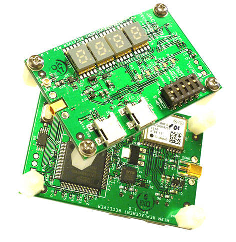
Jackson Labs Technologies Inc. has made available the M12M Replacement Receiver GNSS module that is form-fit-function compatible to the legacy Motorola M12M and M12+ timing and navigation receivers. It uses an eighth-generation GNSS timing-enabled receiver allowing 72 GNSS-channel reception with any two GNSS systems being received simultaneously.
The M12M adds configurability via USB ports as well as dual in-line package (DIP) switches and various status displays. GPS, GLONASS, BeiDou, QZSS and SBAS (WAAS/EGNOS/MSAS/GAGAN) signals can be received.
The module supports NMEA, Motorola binary and u-blox binary, as well as SCPI (GPIB) communication protocols for easy configuration and monitoring, and is designed to allow plug-and-play retrofit of equipment designed for the legacy Motorola receivers, as well as provide an easy design-in for new customer applications, the company said.
The M12M is certified to operate as a plug-and-play upgrade to legacy equipment such as the Symmetricom/Microsemi XLI server, as well as the Jackson Labs Technologies Fury GPSDO, requiring no setup or configuration to operate in those products, and can thus be used to retrofit products for GLONASS/BeiDou compatibility. In the process, the module enhances all performance parameters such as time to first fix; position, velocity and timing accuracy; tracking sensitivity; the addition of SBAS (differential compensation) capability; and the addition of external interfaces such as USB and a synthesized frequency output.
The module supports a satellite tracking sensitivity of down to -167 dBm, allowing indoor reception in typical environments, a 1PPS output with better than 5-nanosecond real-mean-squared (rms) stability (quantization corrected), and a positioning accuracy of typically better than 0.3 meters rms (survey-in) or better than 0.7-meter rms horizontal even in high-dynamic environments such as aircraft missions.
Dynamic auto Kalman filter configuration software allows using changing Kalman filter parameters in real time for improved accuracy, with filter parameters being automatically set dependent on actual mission dynamics. The GNSS timing receiver also supports Auto Survey (Survey-in) operation with Position Hold mode and TRAIM, allowing single-satellite timing reception in challenged or denied stationary environments.
The module integrates a UTC (GNSS)-synchronized NCO synthesizer with buffered output that can generate a user-adjustable frequency from 0.25 Hz to over 10 MHz with extreme frequency accuracy when locked to the satellites. Additional features include operation from various power sources such as USB, or 3V via the M12M compatible connector, as well as a 7-segment LED status display, and numerous DIP switches for easy software-less configuration of the operating modes and desired GNSS systems to be enabled, Jackson Labs said. The module displays Satellite Status information including signal strengths and systems received, and can thus be used as a handheld antenna- and satellite signal distribution-system monitor.
Various optional programs can be used to configure, control and monitor the unit such as GPSD/NTP, GPSCon, Z38xx, u-blox uCenter, TimeKepper, TeraTerm Pro, WinOncore-12 and others. The industry-standard SCPI software interface supports easy-to-use English-language commands such as GPS?, HELP?, and others to monitor and configure the unit, while all advanced GNSS receiver functions such as capturing carrier phase data, assisted start, satellite setup and gating, and health monitoring features are also supported.
M12M Replacement Receiver module samples ship from stock, and are priced at $220 each.
Note: In May 2013 this newsletter published a column on “What’s New in GNSS Simulation.” This month, Editor Tony Murfin takes a brief look at a new start-up in GNSS simulation, Skydel, and its software signal simulator. We also provide quick updates on the latest from those simulation companies and others.
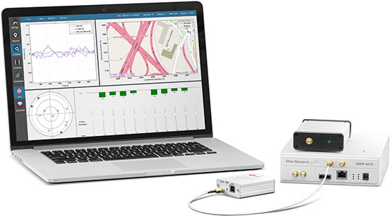
Skydel Software-defined simulator Skydel provides a software-defined simulator using generic hardware to accommodate system integrators who may have a consumer product or application with GNSS inside, and may not require a full-function simulator. Skydel uses a regular GPU to perform modulate the GNSS signal. The computer can be a laptop or desktop, but must include an Nvidia graphics card. The Universal Software Radio Peripheral (USRP) here is the Ettus N210. Skydel also uses the bladeRF x40 made by nuand, an alternative USB 3.0 Software Defined Radio, and Averna RP-6100 Record & Playback system.
“What’s New in GNSS Simulation” Updates
Spirent Spirent debuts practical PNT framework for more robust position, navigation and timing systems Threats to GNSS and related PNT applications are more orchestrated and coordinated, with the motivation to disrupt or cause financial loss. The technology to disrupt GPS has also become much more accessible, resulting in GPS vulnerability even gaining attention at hacker conventions. Spirent’s GNSS Interference Detector System helps users solve these problems.
Rohde & Schwarz Solutions for all aspects of LBS testing Need to verify your location based service (LBS) applications based on A-GNSS, OTDOA and eCID? Rohde & Schwarz offers a wide range of testing solutions for all aspects of LBS testing, including protocol conformance, minimum performance and OTA. Applicable from development and production to installation, the solutions support the positioning techniques and protocols deployed by mobile network operators.
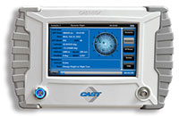
CAST CAST lightweight GPS Satellite Simulator With its compact size of 7 x 11 x 3 inches and weighing in at just over four pounds, the SGX is CAST’s smallest fully capable simulator to date. The SGX lightweight portability features 16 channels of L1 C/A and P codes and is extremely accurate and repeatable. Features include a touchscreen, individual satellite power control and start-and-stop scenarios with the touch of a button.
Spectracom GNSS Simulator Compatible with IRNSS and QZSS Spectracom’s GPS/GNSS simulator is now available for testing receiver compatibility with India’s global navigation satellite system, IRNSS, and Japan’s regional satellite system, QZSS. The Spectracom GSG-6 Series multi-frequency GNSS signal simulator is designed to be field upgradeable to readily enable the addition of all current and future GNSS constellations.
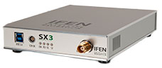
iFEN SX3 GNSS Software Receiver The SX3 Black Edition is a modular dual-RF multi-GNSS software receiver with superior flexibility and performance, whether processing the dual-RF front-end data stream in real-time or post-processing IF samples from storage. Graphical user interface provides easy access to signal processing configuration properties and gives real-time feedback for channel output, correlation function and RF spectrum.
RaceLogic The 2015 leap second – LabSat scenarios now available With the LabSat 3 Simulator you can reliably test your products on the bench to see how they cope with events such as the leap second, alongside standard issues such as multipath and signal obscuration. Recordings of the leap second from the three main constellations are now available for use with LabSat 3.
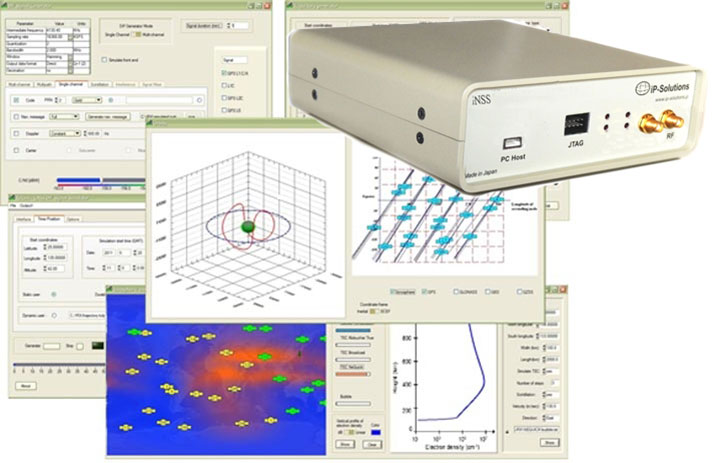
IP-Solutions Replicator GNSS RF simulator, recorder and playback device — inexpensive, economical, flexible, with a high-fidelity GNSS simulation solution. This product was originally developed cooperatively for JAXA (Japan Aerospace Exploration Agency). Originally developed for, and in cooperation with, the Japan Aerospace Exploration Agency (JAXA).
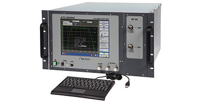
Cobham AvComm ATC-5000NG NextGen ATC/DME Test Set Formerly the Aeroflex AvComm business unit, Cobham introduced this year the ATC-5000NG NextGen ATC/DME Test Set, an RF signal generator/receiver for testing Mode A, C and S transponders. The ATC-5000NG was designed with modern software-defined radio technology for engineering development, design validation, manufacturing and return-to-service testing.
TeleOrbit GIPSIE TeleOrbit’s software-based GNSS multi-system performance simulation environment, GIPSIE, consists of a satellite constellation simulator and an intermediate frequency simulator. The digital signal simulator GIPSIE streams the software-generated signals or recorded live data exactly into the receiver’s baseband processing chain to support development, test, verification, validation, qualification and certification.
Averna RP-6100 The Averna RP-6100 Multi-Channel RF Record & Playback for RF application testing allows users to to record real-world signals such as GNSS, HD Radio, LTE and Wi-Fi, plus impairments, to advance projects and harden product designs. Frequency range of 10–6000 MHz, up to 4×40 MHz or 2×80 MHz bandwidth, 14-bit resolution, tight channel synchronization. Records up to 22 hours, supports Skydel’s software-defined, real-time GNSS Simulator.
Syntony GNSS Syntony RTG2 Constellation Simulator Syntony offers the RTG2, a GNSS constellation simulator that generates realistic GNSS RF signals, taking into account the current and future GNSS constellations. The generator is entirely configurable (troposphere and ionosphere effects, simulated receiver trajectory, etc) through a user friendly interface accessible on a separated PC through Ethernet.
Avago Technologies Ltd. will move ahead with its merger with Broadcom Corporation, following a shareholder meeting Nov. 10 where shareholders overwhelmingly approved the business transaction.
Avago and Broadcom announced their merger agreement on May 28. The companies have received clearance on the proposed merger from the Committee on Foreign Investments in the United States and antitrust authorities in the United States, Japan and Taiwan.
Among other customary conditions to closing, the transaction remains subject to regulatory approvals from the European Commission and antitrust authorities in China and South Korea, all of which are progressing. Avago anticipates that these remaining approvals will be received and expects the transaction to close late in calendar year 2015 or early in 2016.
Avago Technologies is a designer, developer and global supplier of a broad range of analog semiconductor devices with a focus on III-V based products and complex digital and mixed signal CMOS based devices. Its product portfolio includes thousands of products in four primary target markets: wireless communications, enterprise storage, wired infrastructure and industrial, and other.
Chip simplifies integration of GNSS into low-cost products
The Broadcom BCM47748 chip for the Internet of Things and wearables enables devices such as fitness bands to deliver pinpoint location while consuming minimal power and in some cases can eliminate the need for a separate microcontroller. The BCM47748 removes a bulk of the signal processing from the device MCU by calculating position, velocity and time on-chip, delivering significant system power savings. The chip uses intelligent firmware to extend battery life while maintaining accuracy in speed, distance and position. By absorbing location computations on-chip, Broadcom not only reduces power consumption but can also dramatically lower costs for OEMs by replacing the device MCU and reducing board space. Firmware inside the BCM47748 automatically adapts to user activity and context, whether biking, walking or running, to provide precise location results to the user, enabling performance that is not sacrificed for power savings.
Simulation through real-time generation of GNSS signals
The upgraded ReGen DIF simulator is a high-end, low-cost 24-channel GNSS multi-frequency RF simulation solution for academia and research and development. The Replicator provides users with GNSS simulation through real-time generation of GNSS signals; the recording and playback of dual-frequency GNSS RF signals; and GNSS RF signal analysis with the JAXA COSMODE ionospheric scintillation monitor. Features of the replicator support various combinations of GPS L1, L2; GLONASS L1,L2,L3; BeiDou B1, B2; and Galileo E1 signals, and include ANSI C API for user access to customizable signal propagation, orbital, multipath, spatially correlated, scintillation and other error models.
Designed for unmanned aerial systems and mobile platforms
The S2525F8-BD-RTK is a low-power, single-frequency RTK receiver with centimeter-level position accuracy. It supports GPS, BDS, QZSS and SBAS, simultaneously tracking up to 28 satellites. With its 25 x 25 millimeter form factor, 300-mW power consumption and 3 gram weight, it is designed for any outdoor applications requiring high-precision RTK positioning. S2525F8-BD-RTK supports both base station and rover modes. As a rover, it receives RTCM 3.0 or 3.1 data from a base station, or raw measurements from another S2525F8-BD-RTK receiver serving as base station, and performs carrier phase RTK processing to achieve relative positioning with 1 cm + 1 ppm position accuracy within 10-Km baseline.
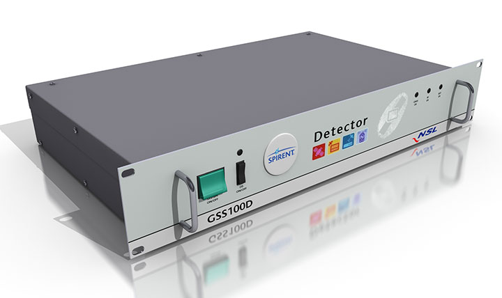
Spirent robust framework evaluates threats to GNSS
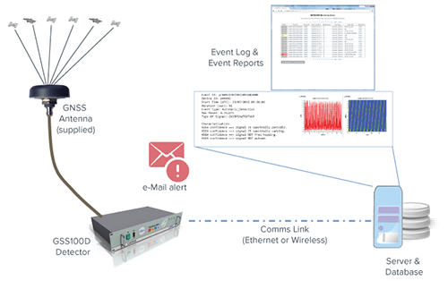
The GSS100D Detector is key to a robust PNT test framework to evaluate GPS and GNSS security vulnerabilities for position, navigation and timing systems. The framework will be used by technology, system and application developers where PNT is critical. The framework enables threats to be detected in the field, taken into the lab, and re-synthesized along with GPS and other GNSS signals. Spirent’s threat intelligence library of actual and typical threats provides a wide range of GNSS segment errors and spoofing attacks, as well as space weather and other vulnerabilities for preventive troubleshooting. Developed in collaboration with Nottingham Scientific Ltd., the GSS100D Detector enables detection, characterization and analysis of real GNSS threats.
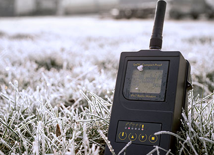
Priate radio data system for measurement applications
Compact-Proof is a UHF radio modem for wireless data transfer with a rechargeable battery, providing a compact and flexible solution for a wide range of applications, including land surveying under varying weather conditions. It supports the radio protocols of Pacific Crest, Trimble and other GNSS providers. It has a temperature range of -30°C to +65°C and frequency ranges of 330 MHz…420 MHz and 403 MHz…473 MHz. Its casing and connectors are rated IP67, making it waterproof and secured against dust. With transmitting power of 1,000 mW, it can be operated fully autonomously for more than 15 hours as a repeater station in the field.
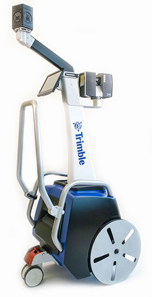
Base station or rover survey receiver with 864 channels
The all-in-one TRIUMPH-LS combines a high-performance 864-channel GNSS receiver, all-frequency GNSS antenna, and a modern featured handheld. The 864 all-in-view channels include Galileo E1/E5A/E5B, GPS L1/L2/L5, GLONASS L1/L2/L3, QZSS L1/L2/L5, BeiDou B1/B2 and SBAS L1/L5. The TRIUMPH-LS offers GUIDE data collection, Visual Stake Out (VSO), navigation, six parallel RTK engines, more than 3,000 coordinate conversions, advanced CoGo features, and rich attribute tagging on a high-resolution, bright, 800 x 460 bright display. Two 3-megapixel cameras enable recording of images along with GNSS data.More than 100 channels are dedicated to continuous interference monitoring. The Triumph-LS monitors and reports interference graphically and numerically with patent-pending interference protection. Interference awareness allows safe GNSS operation in city, airport and military environments. The unit can serve as base or rover. It has a GSM modem, UHF transmit and receive, and an internal high-performance geodetic antenna. The TRIUMPH-LS automatically updates all firmware when connected to a Wi-Fi Internet connection.
The Trimble Indoor Mobile Mapping Solution (TIMMS) produces fast and accurate maps of difficult-to-navigate indoor spaces and translates them directly into 2D and 3D models of structured interiors. TIMMS 2 is a fusion of technologies for capturing spatial data of indoor and other GNSS denied areas, providing both lidar and spherical video and enabling the creation of accurate, real-life representations of interior spaces and all of their contents. The maps are geo-located; the real world positions of each area of the building and its contents are known and can be easily placed and oriented in a wide area model. Small and lightweight, TIMMS 2 can negotiate tight corners, closets and catwalks, and can be carried up and down staircases where no elevator is available for travel between building levels.
The new Leica Geosystems Pegasus backpack wearable mobile mapping solution.
Wearable reality capture
Portable backpack allows mapping while walking
The Leica Pegasus:Backpack is a wearable reality-capture technology that combines five high-dynamic cameras and two LiDAR profilers within an ultra-light and ergonomic carbon-fiber chassis. The ergonomic mobile mapper creates a 3D view indoors or outdoors for engineering or professional documentation while using SLAM (simultaneous localization and mapping) to determine position in GNSS-denied areas. With its fast and efficient capture, calibrated images and point clouds are quickly generated for applications as diverse as BIM 6D to industrial training and disaster analysis.
The YellowScan is a lightweight lidar designed for fixed or rotary-wing UAVs. It has an embedded Ellipse-E, a miniature inertial navigation system from SBG Systems, which helps obtaining a clear and accurate point cloud. YellowScan is operational at up to 75 meters and delivers a highly dense point cloud. It includes a lidar with a ±50 degree angle that measures 40,000 points per second, an Ellipse-E inertial navigation system coupled with a centimeter-level RTK GPS, an on-board computer and an integrated battery. LED lights provide useful information, such as whether the GPS is receiving RTK corrections.
The DJI GO app is an upgrade to the previous DJI Pilot app with a redesigned user interface to make it easier to capture and share images with DJI’s Phantom 3, Inspire 1 and Matrice 100 UAVs. The app includes expanded in-app editing tools to make it easier to adjust photos and videos before uploading to social networks. DJI Director, which automatically edits the best moments from flights into short videos, has also been upgraded to include video speed control, additional templates and background music options.
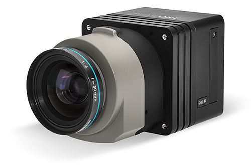
Lightweight with the resolution of a medium format system
The iXU-R camera series for UAVs is available in 80 MP, 60 MP and 60 MP achromatic versions. The cameras feature dedicated interchangeable 40-mm, 50-mm and 70-mm Phase One Rodenstock lenses equipped with central leaf shutters that can be quickly changed in the field, offering flexibility in aerial applications. The Phase One iXU-R systems have been designed to address the aerial data acquisition market’s needs with high-performance optics, flexibility to fit into small places and Phase One’s fastest 80 MP platform. Phase One aerial cameras offer direct communication with GPS/IMU systems and the ability to write data to the image files.
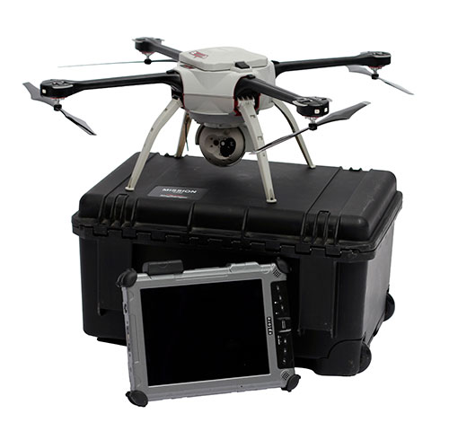
The Aeryon SkyRanger introduces a new airframe and integrated system design to its Aeryon sUAS (small UAS) platform, based on thousands of hours of flight time and successful customer exercises and missions around the world. The SkyRanger is suited for both land and maritime applications, and is designed to military and government specifications for immediate aerial intelligence gathering. Vertical Take-Off and Landing (VTOL) enables continuous eyes-on-target, operations in confined or hard-to-reach environments, and low-risk launch and retrieval without peripheral equipment. Features include up to 50-minute flight time, single operator transport and deployment with no launch or recovery equipment, reliable flight performance in demanding environments such as high winds, and an intuitive touchscreen interface. Microsoft has chosen the SkyRanger to demonstrate aerial image and data capture for its new Microsoft Advanced Patrol Platform (MAPP) vehicle.
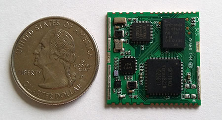
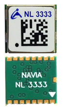
The new GLONASS module Navia NL3333 has been released by the EuroMobile Wireless Solutions Company. The module is made in an original 8.7 millimeter by 9.5 millimeter form-factor on the base of MediaTek MT3333 chipset. The manufacturer has achieved reduced dimensions, as well as significant reduction in a power consumption compared with previous Navia modules. In all such significant improvements, according to the manufacturer, the price remains at an accessible level.
Compared with other modules, the Navia NL3333 has a more flexible power scheme, with an active antenna power supply displayed on the additional output. This allows the customer to save space on the board using a passive antenna or install the necessary RF isolation (inductance) when an active antenna is necessary.
Though labeled a GLONASS receiver, the Navia uses all of the GNSS constellations: GPS, GLONASS, Galileo, QZSS and BeiDou. NL3333 has high sensitivity and fast time to first fix (TTFF). The module includes a noise reduction 12-step system. The module power range is 2.8 – 4.2 V, which can successfully be used in projects powered by Li-Pol batteries. The module connection is via UART, and the data are issued by NMEA protocol.
The EuroMobile Wireless Solutions Company will display its latest developments at booth 81В40 at the 2016 Navitech exhibition, which will be held May 10-13 at the Expocentre Fairgrounds in Moscow.
Trimble has introduced a new grandmaster clock to address the synchronization needs of the fast growing next-generation LTE-Advanced and small cell network market. The Thunderbolt PTP Grandmaster Clock (GC), coming in the first quarter of 2016, was introduced at the ITSF 2015 Time and Synchronization in Telecoms Conference, held in Edinburgh, UK, Nov. 2-5.
Trimble said it value-engineered the industry-standard grandmaster clock, focusing on the features required in next-generation networks, including dual gigabit Ethernet ports and a small form-factor pluggable module port for optical connections. Its low price point enables network architects to move the timing source from the core to the edge of the network, enabling higher phase and frequency precision at the Precision Time Protocol (PTP) clients.
“Trimble entered this market to expand on our success in GNSS timing solutions for telecom networks,” said Karen Guldan, general manager of Trimble’s Time & Frequency Division. “The design and development of the GC focused on creating an optimized solution for network providers — at a price point of less than $2,000, it is intended to be a game-changer in small-cell network design. The GC’s features provide superior value to service providers.”
With flexible network interface protocols and easy integration, Trimble optimized the GC to deliver precise frequency and phase synchronization signals for LTE-Advanced and small cell networks supporting IEEE 1588 PTP, Network Time Protocol (NTP) and Synchronous Ethernet simultaneously. The GC supports up to 250 simultaneous PTP clients and 5,000 NTP transactions per second, and is designed for small- and medium-scale deployment.
With a small form factor of half rack 1RU, users may deploy the Trimble GC either indoors or outdoors. In a server room, the Trimble GC deploys in a side-by-side configuration to provide timing redundancy. For outdoor applications, the Trimble GMC also features an extended operating temperature range for use in non-typical networking environments such as a telecom cabinet. The Trimble GC configures for AC and DC power.
The GC was designed to provide continuous availability of traceable time. The GC includes an embedded, multi-GNSS (GPS, GLONASS, BeiDou and Galileo-ready) receiver to generate precise 10MHz and pulse per second outputs. Utilizing the latest in GNSS technology combined with a precision oscillator, the GC provides better than 3 microsecond phase holdover over a 24-hour period.
The Trimble Thunderbolt PTP Grandmaster Clock is expected to be available in the first quarter of 2016.
According to Spirent, “The use of unmanned aerial vehicles (UAVs) is starting to take off in commercial and military sectors. The potential applications of UAVs are many – including survey, mapping, media reporting, delivery, reconnaissance, conservation and search & rescue. What’s more, in some cases the cost of using UAVs has been found to be up to 98.8% cheaper than manned aircraft.
“But it is still early days, and for designers and developers of UAVs, there are many challenges in bringing viable models to market and putting them to work.”
The ebook looks at those challenges and sets out the main positioning and navigation considerations that UAV test teams should incorporate into their test regime, Spirent said. It covers:
GNSS/GPS performance considerations — how to evaluate positioning capabilities of UAVs
UAV design considerations, including where GNSS receivers should be placed, the type of antenna needed and more
Which environmental/external factors need to be considered, such as wind, temperature and multipath effects
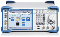
German research organization Fraunhofer Gesellschaft has developed and presented an over-the-air (OTA) wave-field synthesis system for test and certification of GNSS receivers. The testing platform is at its Fraunhofer IIS Facility for Over the Air Research and Testing (FORTE) in Ilmenau, Germany.
The innovative and complex OTA test system is based on hardware and software solutions from IZT GmbH, such as powerful RF receivers and high-performance signal generators.
The demonstrated setup to test GNSS receivers represents a new approach that — in contrast to conventional conducted and open-field tests — realistically emulates real-world scenarios under controllable and repeatable conditions, enabling the realistic comparison of receivers and algorithms. The OTA test system is cost-effective, flexible and scalable.
The newest generations of mobile communication systems employ multiple antennas for transmission and reception, such as LTE, LTE-A, WIMAX and Wireless LAN. Multiple Input Multiple Output (MIMO) OTA test systems are typically deployed for certification, performance testing and product evaluation of broadband wireless devices. The related devices have to be tested in their related environments.
In contrast to mobile phones, GNSS receivers are extremely susceptible to all types of interference. Hence, the goal was to develop a new testing method for interference robustness of GNSS receivers.
The OTA Test Approach
The OTA test laboratory comprises a satellite signal emulator (Spirent) used as signal source, several OTA channel emulators used for wave-field synthesis that are able to emulate any electromagnetic environment in an anechoic chamber, and several OTA illumination antennas. The OTA channel emulators from IZT GmbH support 8 input and 32 phase coherent output channels (up to 256 logical channels) in the frequency range of 1 to 6 GHz, and provide the output signals to the OTA illumination antennas. Note that the final extension of the system based on the IZT components will have 12 x 32 channels.
The unique test environment developed at FORTE together with IZT GmbH excels in its great flexibility regarding possible applications in communications technology. The new OTA emulation approach enables realistic radio channel emulation taking into consideration multipath propagation, multi-frequency, and multi-user scenarios.
The OTA system supports emulation of complex channel impulse responses of nearly unlimited length. Besides GNSS equipment, the test system can be applied for LTE and Cognitive Radio (CR), sensor networks (including energy networks and smart metering) or car-to-car and car-to-infrastructure communications.
The Innovationszentrum für Telekommunikationstechnik GmbH IZT is a spin-off of the Fraunhofer-Gesellschaft, Germany’s leading institution for applied research. Founded in 1997 in Erlangen, the company emanated from the Fraunhofer Institute for Integrated Circuits (IIS). It specializes in advanced digital signal processing and field programmable gate array (FPGA) designs in combination with high-frequency and microwave technology.