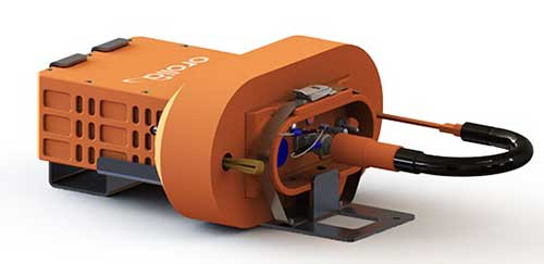
All newly-built commercial aircraft must adhere to safety standards that go into effect Jan. 1, 2021. Orolia, which develops new technology for the Global Aeronautical Distress Safety System (GADSS), offers the Kannad Ultima-DT Distress Tracking Emergency Locator Transmitter.
It features a trigger-in-flight capability to detect imminent emergency situations and send a secure distress signal, including the aircraft’s position, to continuously track its location in any circumstances. The transmitter also includes Return Link Command Service to activate a distress signal from the ground in case of uncertainty about the aircraft’s status, or if attempts to communicate with the flight crew are unsuccessful.
What is the biggest safety challenge for autonomous vehicles?
John Fisher. (Photo: Orolia)
“Sharing the road with human drivers. Optimized safe driving algorithms are compromised to mesh with the human’s natural level of risk taking. But this reduces safety, delaying acceptance — a real conundrum. Now, if we could just eliminate the humans…” John Fischer
Orolia
Julian Thomas
“When AI systems can deal with 99.9% of situations, the challenge will be keeping the passenger engaged to take over quickly when the 0.1% happens. Imagine a truck in front with a load coming loose. Which one would you trust?” Julian Thomas
Racelogic
Members of the EAB
Tony Agresta Nearmap
Miguel Amor Hexagon Positioning Intelligence
Thibault Bonnevie SBG Systems
Alison Brown NAVSYS Corporation
Ismael Colomina GeoNumerics
Clem Driscoll C.J. Driscoll & Associates
John Fischer Orolia
Ellen Hall Spirent Federal Systems
Jules McNeff Overlook Systems Technologies, Inc.
Terry Moore University of Nottingham
Bradford W. Parkinson Stanford Center for Position, Navigation and Time
Safran and Orolia are partnering to offer the latest resilient positioning, navigation and timing (PNT) solutions for military forces, especially in GNSS-denied environments.
This partnership will provide mission-critical equipment for air, land, sea and space programs in environments where GNSS signals are not available or degraded. Whether the outage is unintentional or intentional (jamming, meaconing or spoofing), the Safran-Orolia partnership will provide an alternative to GNSS-dependent military systems.
The Safran-Orolia team will offer military forces an unparalleled convergence of PNT capabilities, including Orolia’s portfolio of precise timing references and PNT sensor-fusion technology, as well as Safran’s proven defense inertial navigation solutions. Initial program priorities include navigation warfare (NAVWAR), along with mobile and fixed PNT solutions.
“Today’s military operations are increasingly mobile and global, with mission priorities that often bring them into territories where GNSS jamming and spoofing are becoming common threats,” said Orolia CEO Jean-Yves Courtois. “We’re proud to introduce this unique resilient PNT military partnership to better protect and enable mobile operations for NATO and allied countries worldwide.”
“In a world full of uncertainty, our partnership will provide autonomous and sovereign PNT solutions to Armed Forces facing harsh GNSS denied environments,” said Safran Electronics & Defense Chief Executive Officer Martin Sion.
Orolia’s PNT solutions improve the reliability, performance and safety of critical, remote or high-risk operations. With locations in more than 100 countries, Orolia provides virtually failsafe GNSS and PNT solutions to support military and commercial applications worldwide.
Safran is an international high-technology group, operating in the aircraft propulsion and equipment, space and defense markets. Safran has a global presence, with more than 92,000 employees and sales of 21 billion euros in 2018.
With the smartphone revolution, we are increasingly reliant on today’s global technology networks. The importance of protecting data centers and mobile devices with resilient PNT can’t be overstated. But what is the best way to accomplish this?
By Rohit Braggs, Orolia
Connected devices and cloud applications are the primary technology sources for most people today, and an exponentially growing number of those devices are connected to data centers in some way. Across the world, you can drive past countless acres of data centers that are storing, updating and retrieving the world’s data.
GNSS signals localize and timestamp the data collected from connected devices scattered across the world in diverse time zones and locations. They also provide the critical time synchronization that supports high-efficiency data storage, routing and exchanges across multiple data centers in various locations.
It is essential to protect data centers and their GNSS signal connections from system failure, jamming, spoofing, interference and denial of service. As the reliance on GNSS signals and the number of connected devices grow, so too does the threat of GNSS failure. False or unavailable positioning, navigation and timing (PNT) information at any point within this network can compromise security and completely disrupt user service.
This article explores the role of data centers and how their constant connection to devices enables almost every digital technology that we use today. It identifies key reasons why we should protect this interconnected data system from GNSS signal interference and disruption, in addition to providing information on how to ensure continuous signal monitoring and protection with a practical, cost-effective approach.
Data centers and connected devices affect nearly every aspect of our digital lives, from cloud software and applications to mobile phones and laptops. They store our personal documents, photo libraries and other priceless personal data. They also keep track of business documents, software licenses and other essential business information. In critical infrastructure, they support the daily operations of society’s most important services such as public utilities, banking and financial transactions, telecom, security, medical and defense systems, among others.
Data centers use timestamps as a key mechanism to store, organize and retrieve data. In addition to categorizing data by authorized users and other relevant identification information, the timestamp enables data centers to monitor revisions and retrieve the most recent version of the data.
A good example of timestamped data use is in cloud-based applications, accessed simultaneously by hundreds of thousands of users. In such environments, data is dynamic and changing frequently, which can lead to data conflicts. With accurate, reliable timestamps, a cloud-based application can resolve such conflicts to determine the order in which the data was received.
Why do we need to protect data centers and connected devices from GNSS signal interference?
GNSS signals are the quiet facilitators of many of our day-to-day tasks. In discussing why it is important to protect these signals, it is often easier to imagine what would happen without the accurate, reliable PNT information that these signals provide.
We need to understand two key pieces of information to operate systems: location and time. We need to know exactly where data or assets are located, and we need reliable, consistent time references to synchronize the movement of data and assets for system operations.
There are many documented examples of GNSS signal jamming, spoofing and denial of service attacks worldwide, and these are easy to find with a simple internet search. Here are a few examples of what can happen when the signal is compromised at a mobile or fixed location, but not taken offline. The user might still see that the signal is working, with no indication that the two critical pieces of information, location and time, are being disrupted:
Imagine that the timestamp on a security camera system was spoofed to show a different time than the actual time. Incorrect or missing timestamps on video from surveillance systems is the most common reason for video evidence being deemed as inadmissible in a court of law. A bad timestamp corrodes the credibility of the video as irrefutable evidence and makes it easy to dispute.
Imagine that a bad actor spoofed the time used by financial trading systems. Since these critical systems rely on GNSS-based time and synchronization, an attack on their underlying timing infrastructure could significantly impact the market and cause billions of dollars in damage.
What if the GPS guidance system on your phone or vehicle gave you wrong directions? You could get lost in a wilderness or encounter dangerous driving conditions by trusting the route shown on your device.
What if more people started using commercially available jammers? Some truck drivers have already been caught using unauthorized GPS jammers in their vehicles to avoid monitoring by their employers. In many cases, these deevices have affected nearby critical systems such as air traffic control, financial data centers, and other critical operations simply by being driven past with active jammers. The incidence of these disruptions is on the rise.
Imagine a secure facility using an access control system that is set to automatically lock and unlock doors at a specific time. If someone spoofed the time used by that system, they could trick the doors into unlocking and gain entry.
We are also seeing an uptick in unintentional or environmental signal interference, which can occur in high-density development areas where various wireless transmitting systems can interfere with GNSS reception.
Which technology solutions are best suited to protect data centers and GNSS signals?
The first step toward protecting a GNSS-reliant system is to test the system for vulnerabilities. GNSS simulators and testing protocols can simulate a spoofing, jamming or denial of service attack to evaluate how the system responds to each situation. Knowing the system’s unique challenges and weaknesses can help resilient PNT experts design the best solution for that system.
One of the most common configurations for a fixed site location includes a highly reliable network time server to ensure that accurate timestamps are applied to each data point. A time server that can identify erroneous or spoofed GNSS signals is recommended for any critical application. In addition, a time series database could be installed to categorize and organize the time-stamped data, while identifying any irregularities in the data.
Once you have reliable timestamps and time server management systems, you also need to continuously monitor the signal to detect interference and raise an alarm. A GNSS signal monitoring system can let you know the minute your system is under attack. A GNSS threat classification system can identify the type of threat and mitigate it, depending on the nature of the threat, by filtering the signal to neutralize the interference.
The best way to prevent GNSS jamming is to deny interfering signals access to the receiver in the first place. Smart antenna technology focuses antenna beams to track the good signals from the satellites and reject the bad signals from interferers. Less sophisticated solutions such as blocking antennas can be employed to reject terrestrial-based interference, which is where most GNSS interference sources exist, and they provide a good first-level protection.
Continuous PNT access can also be achieved by using an alternative signal that operates separately from GPS/GNSS and is less vulnerable to the signal attacks that plague GNSS signals.
Emerging PNT Technologies
Over the next few years, new applications of mobile PNT data will further emphasize the need to maintain system integrity against threats. Here are a few examples of emerging technologies.
5G is here for mobile Internet and telecom service, yet with the specific need for microsecond-level synchronization, the challenge to protect the fidelity of the time used in these systems will become more important.
With rising awareness of the need to protect GNSS signals against threats, individuals will need to determine how they can protect their own GNSS-reliant systems as they navigate the Internet of Things and GIS enabled e-commerce. Personal PNT protection is an emerging technology area that could help protect people and their mobile devices on an individual basis, to ensure GNSS is there when it matters. Whether you are embarking on a remote hiking or sea expedition, sharing your coordinates with an emergency dispatcher after an accident, or simply trekking your way through a new city late at night, having resilient GNSS signal support is becoming a necessity.
Alternative signals are now available, and these new signal options, such as STL (Satellite Time and Location), could play an important role in providing better privacy and security functionality. This signal diversity will help protect against threats and interference by adding resilience to the device’s ability to receive reliable PNT data.
Another exciting technology development is the concept of smart cities, where technology has the opportunity to increase efficiency, reduce waste and provide many conveniences for the public. As we automate more city systems, it is essential to protect these systems from both accidental and malicious GNSS-based interference to ensure that these systems can make decisions based on reliable, precise PNT data.
Intelligent Transportation Systems (ITS) have the capacity to transform how people and freight travel today, saving lives and bringing goods to market more efficiently than ever. The need to know exactly where a driverless vehicle is in relation to other vehicles at any moment in time is just one of the resilient PNT technology requirements that will rely on GNSS signals.
Finally, authenticated time and location information can help increase cybersecurity for many applications, by limiting data access to a very specific window of time and only in a precise location. This is an area of cybersecurity which has the potential to add new layers of authentication to protect users and their data. With connected devices at the forefront of our access to the world, secure and reliable PNT technologies are more critical than ever.
These are just a few examples among many of the new technology innovations that are in the works to provide us with new benefits in leaps and bounds.
Protecting Our Virtual Brain
Data centers are the technology hubs of today, and their constant connection to devices fuels our ability to access critical information instantly. This networked system serves as a virtual brain that holds our personal memories, charts our progress, enables us to share results and helps us deliver new technology advancements faster than we could ever do before.
As we prepare to embrace our new technology, we should first address the PNT technology challenges of today and ensure that our GNSS signals are resilient and reliable. With this strong foundation in place, we can better protect our current systems and keep pace with evolving threats that would otherwise jeopardize the functionality, safety and security of these new capabilities.
Rohit Braggs is the chief operating officer at Orolia. Based in Rochester, New York, he is responsible for the development and execution of the company’s global business strategy and corporate initiatives. He also serves on the board of directors for Satelles Inc., which provides time and location solutions over the Iridium constellation of low-Earth-orbiting satellites.
By Jeremy Onyan, Director, TIme Sensitive Networks, Orolia
Cybersecurity is critical to all facets of the internet. Companies spend millions on cybersecurity every year. Still, often-overlooked areas degrade security. A key example of this is time.
Time plays an essential role in synchronizing core business and network systems. It supports authentication protocols as well as accurate log files critical for an audit trail — necessary for any cyber forensics program. As such, synchronization is often a requirement for network security standards.
A deployment of network time protocol (NTP) synchronizes a local system to a time server. The time source can come from within the network or outside of it.
NTP over the internet. NTP time servers are widely available on the internet. National authorities operate internet time servers based on extremely accurate atomic clocks, such as the National Institute of Standards and Technology (NIST) or the U.S. Naval Observatory.
But even with these sources, many factors impact traceability. According to ntp.org, “If business, organization or human life depends on having correct time or can be harmed by it being wrong, you shouldn’t ‘just get it off the internet’.”
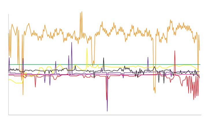
One problem with time synchronization is the variability of network conditions. Network load, variable path delays and firewall settings can impact time quality on the local system. To illustrate this effect, we can use the time-quality monitoring feature of a time server with a built-in GPS receiver as its reference that is accurate to tens of nanoseconds. NTP can be used to compare it to another GPS time server on a local area network. The offset is around 15-20 microseconds (Figure 1).
Figure 1. The comparison between two GPS time servers on the same LAN using NTP results in 15–20 microseconds offset. (Chart: Orolia)
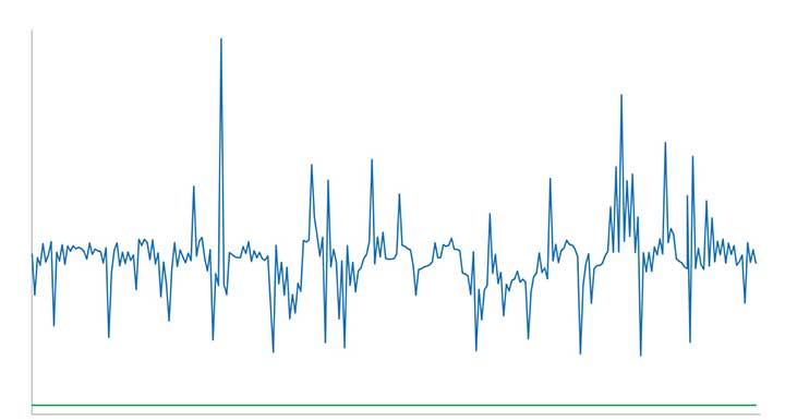
We connected the SecureSync time server to some of the most popular internet time servers. The variation result, shown in Figure 2, is as high as tens of milliseconds — 1,000 times worse than NTP across a local area network. If we assume all the time servers are accurate, then the difference is solely due to greater path delay and other dynamic conditions. This variation is enough to question the traceability of time from the internet.
Figure 2. The comparison of internet time servers as measured by NTP on a local GPS time server. The scale is 1,000 times greater than in Figure 1. (Chart: Orolia)
The internet obscures time traceability. Perhaps more important for a security-critical network is the validity of the source used by the time server that distributes time to your network. Time from GPS/GNSS signals is recognized as the most accurate, available and traceable time source.
GPS/GNSS-based time servers are easy and simple appliances to add to the local network. Even when different GPS/GNSS time servers are deployed in different locations, they will provide the same time regardless of geography. What’s more, GPS/GNSS as a local time source can be monitored, so its logs can become part of the audit trail.
Of the seven internet time servers monitored over a 24-hour period, 20 different time sources were identified. Less than half of the sources could be identified as coming directly from GPS/GNSS. In one case, GPS/GNSS time was distributed through three different time servers.
The best practice of using NTP server pools is one reason why there are more sources than time servers. Server pools rotate among various internet time servers, each with their own source of time, to reduce the chance of one bad or unavailable time server catastrophically affecting the synchronization. But this is a problem for traceability. The source of time is not known, nor can it even be determined.
Indeterminate source identification, indeterminate accuracy variation and the inability to log the resulting time synchronization calls into question the efficacy of getting time from the internet. Internet time servers are also subject to being spoofed (bad NTP data sent from a faked IP address) and to direct attacks, including NTP poisoning, replay and denial of service.
When there is a business-critical need to trace time to an accurate source, a GPS/GNSS-based time server should be deployed on the local network.
Dean Kemp, defense segment manager for NovAtel, has joined the speakers’ panel for the June 27 complimentary webinar, Advanced Simulation Test Systems for Controlled Reception Pattern Antennas. He will present unique content alongside Lisa Perdue, simulation product manager for Orolia, and Stéphane Hamel, director of testing at Orolia.
Kemp has over 20 years of academic, industrial and business experience in engineering products and services. He spent a significant part of his career involved in antenna design and development, including controlled reception pattern antennas (CRPAs) for GPS anti-jam systems. As Defense Segment Manager, he is committed to precise, assured positioning and timing to address the needs of Navigation Warfare (NAVWAR) professionals and is dedicated to delivering high-quality products into the defense markets.
He holds a Ph.D. in antennas, radiowave propagation and computational electromagnetics from the University of Liverpool and an MBA from the University of Warwick. Prior to joining NovAtel, he worked at API Technologies, Cobham and Cobham Technical Services. His key technical skills include antenna/RF/microwave engineering, software development (Matlab, Fortran, VBA, Python), data analysis and processing, and test and measurement.
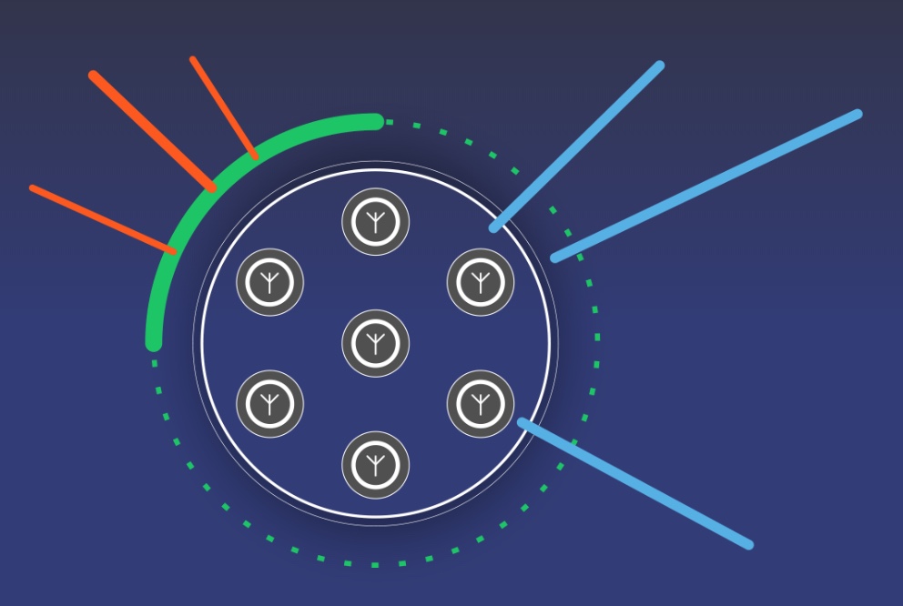
CRPAs are advanced, multi-element antenna solutions designed to protect a GNSS/GPS receiver from jamming sources. When combined with antenna electronics, they form an anti-jam antenna system (AJAS). These systems utilize several available technologies and vary in the number of elements.
This webinar will cover the basics of AJAS and CRPA, and the methods used to test them. Details on simulation system configurations, calibration techniques, and use case examples will also be presented. The webinar is sponsored by Orolia, a global provider of GPS/GNSS and resilient PNT solutions to support military and commercial applications.
Orolia’s Kannad Ultima-S emergency locator uses the Galileo Return Link Service. (Photo: Orolia)
Orolia is introducing a new product for commercial aircraft safety, the Kannad Ultima-S emergency locator transmitter (ELT).
The Kannad Ultima-S is designed to be installed in the cabin of commercial aircraft or in its life raft. It is capable of notifying the crew about the launch of a search-and-rescue operation via Galileo Return Link Service (RLS).
For passengers, installation of the Kannad Ultima-S means their flight can located accurately, with rescue following if an aircraft evacuation is needed.
Orolia’s Kannad Ultima-S ELT was developed under a two-year contract through the European GNSS Agency’s Tauceti Project. Orolia says this is the first beacon to use the Galileo RLS.
Other key features include:
Certified to the new lithium battery regulations to avoid the risk of battery fires.
A multi-GNSS receiver to accept multiple signals such as GPS and Galileo to detect the aircraft’s
location faster and deploy rescue teams sooner than before.
Dual activation modes: manually or automatically upon contact with water.
An RLS option to notify the crew that the distress signal has been received and help is on the way (available on Galileo).
Multiple configurations available to install in aircraft cabins and life rafts. With a rugged, compact, and easy-to-install form factor, both versions can be installed through a carry-off bag or a mounting bracket and require little storage room.
Orolia’s Kannad Ultima-S meets new and evolving EASA/FAA requirements related to ELTs and non-rechargeable lithium batteries documented under the RTCA DO-227A standard.
“Orolia is dedicated to making air travel even safer than it is today with resilient positioning and aircraft location technology, featuring automatic, manual and remote activation modes to provide a complete ELT portfolio,” said Christian Belleux, Aviation Product Line director at Orolia. “We are excited to present aircraft operators with an affordable, reliable and state-of-the-art ELT solution for cabin modifications or linefit installations.”
The new ELT benefits from the proven Cospas Sarsat infrastructure, which is being upgraded to provide highly accurate location data and nearly real-time reporting to search-and-rescue operators through global coverage.
Kannad Ultima-S survival distress beacons complement Orolia’s Ultima family of next-generation ELTs, following the company announcement of the Global Aeronautical Distress and Safety System (GADSS)-compliant fixed Ultima-DT. Orolia provides aircraft manufacturers and operators with a complete solution for every ELT application.
Orolia will exhibit at the Paris Air Show June 17-20, Hall 2B booth E32, where both new ELTs will be displayed for the first time.
Protection from jamming has emerged as the key concern of of both national and organizational/corporate infrastructures. The world abounds in bad actors, and systems based on GNSS signals are uniquely vulnerable. A basic component of any anti-jamming (AJ) strategy is a shielded antenna. An upcoming webinar, June 27, gives a primer and several advanced looks at developing such an antenna-based AJ campaign. Register here for the complimentary webinar.
Anti-jam antennas use techniques, such as nulling or beam-forming, to mitigate the effects of interfering signals. (Image: Orolia)
Controlled reception-pattern antennas (CRPAs) are advanced, multi-element antenna solutions that protect a GNSS/GPS receiver from jamming sources. When combined with antenna electronics, they form an anti-jam antenna system (AJAS). These systems utilize several available technologies and vary in the number of elements.
CRPAs will play an increasing role in the GPS/GNSS landscape. Initially developed in the military domain, they are now entering the civilian market and are poised to bring their benefits to the fields of aerospace, ground transportation, autonomous driving and others. Engineers working with GNSS systems that employ CRPAs and multi-element antennas need special test systems since they need to replicate very specific test conditions that are impossible with live signals.
These complex antenna systems require advanced GNSS simulation equipment in order to be designed and validated, as well as to test their performance. These test systems come in two forms — an anechoic chamber system used to test the CRPA antenna over the air, and a wavefront simulator used to test the antenna electronics with a direct cable connection.
Webinar speakers:
Perdue
Lisa Perdue, Product Manager, Orolia. Perdue is an expert in testing critical GPS and GNSS systems. She has trained hundreds of engineers and technicians who are responsible for high-reliability positioning, navigation and timing applications. She took a lead role in the development of the first GNSS Vulnerability Test System and speaks widely on the topic at many industry conferences.
Hamel
Stéphane Hamel, Director, Testing, Orolia. With a career spanning more than 20 years in engineering test and RF, Hamel has developed many innovative and large-scale products to test semiconductor devices, radios and GNSS receivers. In 2014, he founded Skydel, now part of Orolia. Hamel is one of the architects behind the Skydel SDX GNSS simulator.
Orolia, a provider of resilient positioning, navigation and timing (PNT) solutions, announced that its SecureSync time and synchronization servers have been selected to support enroute radar systems across the U.S.
The selection comes as part of the Federal Aviation Administration’s (FAA) move towards a Next Generation Air Transportation System (NextGen). NextGen is about halfway through a multi-year investment and implementation plan.
The FAA plans to keep rolling out NextGen technologies, procedures and policies through 2025/2030 and beyond.
While NextGen will rely heavily upon GNSS to increase capacity, efficiency, and safety in the National Air Space (NAS), many technologies including legacies such as radar will be integrated into the system for maximum robustness to error and disruption.
The FAA employs a variety of radar types for short-, medium- and long-range air traffic control requirements. These diverse radars require different types of timing signals and outputs to suit their operations.
SecureSync. Orolia’s SecureSync provides the necessary timing outputs and signals to meet these requirements. The time server’s ability to provide resilient, accurate and reliable timestamps for the data that it receives from radars is used to quickly organize the data for the aircraft control user interface.
The only time and synchronization device approved by the Defense Information Systems Agency (DISA) for use in U.S. Government networks, Orolia’s SecureSync provides reliability, security and flexibility to synchronize critical aviation operations. SecureSync combines multi-GPS/GNSS signal synchronization, options for alternative signals and BroadShield GPS anti-jamming/spoofing protection for transportation systems. SecureSync combines Orolia’s precision master clock technology and secure network-centric approach with a compact modular hardware design.
The FAA selected Orolia for the competitive program based on its proven timing and synchronization technology and its ability to offer multiple output options as commercial off-the-shelf (COTS) products that do not require additional research and development time or investment.
“Consistently accurate timestamps and the synchronization of thousands of real-time flight data points are essential for safe and efficient enroute air traffic operations,” said Jean-Yves Courtois, CEO of Orolia. “Orolia is proud to support the FAA’s radar data and aircraft control user interface requirements to improve air travel services nationwide.”
More About the SecureSync COTS Product. Built-in time and frequency functions are extended with up to 6 input/output modules. Included with the base unit is a 1PPS timing signal aligned to a 10 MHz frequency signal without any 10 MHz phase discontinuity.
A variety of internal oscillators are available, depending on requirements for holdover and phase noise. On-board clocks synchronize to a variety of external references as standard, factory-installed or upgradable options.
Users may add alternate signals of opportunity to GPS or GNSS input references to improve resilience, or use them for indoor applications and choose from a variety of option cards to add to configuration of timing signals, including additional 1PPS, 10 MHz, time code (IRIG, ASCII, HaveQuick), other frequencies (5 MHz, 2.048 MHz, 1.544 MHz), telecom T1/E1 data rates, multi-network NTP and PTP. Modules can be customized for exact requirements.
To support network time synchronization, SecureSync supports the latest features of network time protocol (NTP) and precision time protocol (PTP, IEEE-1588v2). An optional multi-port NTP configuration allows for operation across 4 isolated LAN segments. Up to 6 PTP ports can be added to operate in various PTP deployments.
SecureSync is a security-hardened network appliance designed to meet rigorous network security standards and best practices. It ensures accurate timing through multiple references, tamper-proof management and extensive logging. Robust network protocols are used to allow for easy but secure configuration.
Features can be enabled or disabled based on network policies. Installation is aided by DHCP (IPv4), AUTOCONF (IPv6), and a front-panel keypad and display. The 1 RU chassis supports multi-GNSS (GPS/ Galileo/GLONASS/BeiDou/QZSS) input.
Options include SAASM, supporting L1/ L2, available for authorized users and required for the US DoD, and BroadShield GPS jamming and spoofing detection. The unit is powered by AC on an IEC60320 connector. DC as back-up, or primary, is available.
Atomic clocks support world’s first black hole photo
Orolia, through its joint venture company T4Science Inc. in Switzerland, supported the ground-breaking scientific initiative to capture the world’s first photo of a black hole, conducted by the Event Horizon Telescope (EHT) project.
As a leader in maser atomic clock technology, Orolia provided the critical timing solution to synchronize telescopes around the world and create a virtual telescope the size of Earth to observe this deep space, supermassive object.
Some of the world’s most advanced telescopes, located at challenging high-altitude sites, were synchronized with T4Science Masers to capture the sharpest image possible. Locations included volcanoes in Hawaii, Arizona mountains, the Spanish Sierra Nevada, the Chilean Atacama Desert and Antarctica.
T4Science masers deliver ultra-precise time synchronization in the most challenging environments on Earth and in Space.
The EHT project uses very long baseline interferometry (VLBI). This technology requires synchronization, phase stability and phase coherence between different telescopes within a few femto-seconds, and leverages the Earth’s rotation to form one Earth-size telescope.
VLBI enables the EHT to achieve an angular resolution of 20 micro-arcseconds — enough to read a newspaper in New York from a sidewalk café in Paris.
Orolia delivers this critical VLBI technology through its T4Science iMaser-3000 hydrogen masers. The iMaser-3000 is a VLBI atomic clock, supporting other mission-critical timing programs such as military and commercial satellite applications.
“Orolia has been a proud supporter of space research and missions for more than forty years,” said Orolia CEO Jean-Yves Courtois. “As the world leader in resilient positioning, navigation and timing solutions, we develop precise, ultra-reliable technology for environments where failure is not an option.”
Orolia’s proven timing solutions support many space agencies and research institutes worldwide, including ESA, NASA, Jet Propulsion Laboratory, SpaceX, the Centre National d’Étude Spatiales (CNES France), the National Physics Laboratory (UK), Deutsches Zentrum für Luft-und Raumfahrt (DLR Germany) and the Japan Aerospace Exploration Agency (JAXA), among others.
The CAST-5000 produces a single coherent wavefront of GPS RF signals to provide repeatable testing in the laboratory environment or anechoic chamber. The basic system generates four independent, coherent simulations that reference a single point and is upgradeable to support seven elements for CRPA testing. With an intercard carrier- phase error of less than 1 millimeter, the CAST-5000 is extremely accurate.
The system generates a wavefront of GPS when its GPS RF generator cards are operated in a ganged configuration. Each generator card provides a set of GPS satellites coherent with the overall configuration. Several RF generator cards may be utilized together, ensuring phase coherence among the bank of signal generator cards.
The CAST-5000 Controlled Reception Pattern Antenna (CRPA) tester allows a full end-to-end test of the antenna system. The CRPA antenna, antenna electronics and the GPS receiver can be tested as a unit with or without radiating signals.
The CAST-8000 is a new simulator that merges both the CAST-5000 CRPA tester with a CAST-3000 EGI tester.
The tiny 1-inch square Micro-Transcoder module allows glueless retrofitting of existing GPS equipment with secure and Assured-PNT (A-PNT) capability. It is the smallest, full-constellation, stand-alone, real-time 10-channel GPS simulator available from JLT. The unit is useful in upgrading existing legacy GPS receivers with external position, navigation and timing references such as INS, CSAC, SAASM, M-code, GNSS, eLoran or other alternative positioning and timing sources by simply replacing the legacy GPS antenna from an existing GPS system with the Micro-Transcoder RF output.
The unit is based on the JLT CLAW GPS Simulator and RSR Transcoder technologies, and includes a general-purpose, stand-alone, full-constellation, 10-channel, real-time GPS simulator with integrated high-stability timing reference, as well as an internal GNSS receiver for monitoring the RF output signal for quality and accuracy. The unit will transmit a standard UTC time, position, velocity and heading GPS L1 C/A RF signal by simply applying 3.3V power to it.
The Micro-Transcoder can also be operated as a generic GPS simulator with built-in GPS Disciplined Oscillator (GPSDO), and is supported by a free Windows application downloadable from the JLT website. The Windows application allows control of all the simulation aspects, creating and storing simulation vector commands and testing user equipment for leap-second and GPS week rollover event compatibility to identify weaknesses in user equipment. The unit does not require a connected PC to function. The Micro-Transcoder is also available mounted onto an evaluation board for easy evaluation. The unit transcodes baseband PNT NMEA signals into a GPS L1 RF signal with typically less than 100-ms latency. UTC 1PPS timing-transfer accuracy to the GPS RF output is typically better than 5 ns. The unit requires only 3.3V to operate, and setup, location and simulation vector file information can optionally be stored in its internal NV memory.
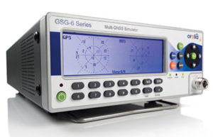
For those responsible for mission-critical PNT applications, the Orolia GSG series of GPS/GNSS simulators is an important tool to evaluate risk for jamming, spoofing or any other threat. Orolia GSG-5/6 series simulators are easy to use, feature-rich and affordable, offering a way to harden GPS-based systems without the limitations of testing from “live sky” signals. The Orolia platform approach allows customers to buy only what they need today and upgrade later. The adaptability of the GNSS RF generation platform can extend to applications for intelligent repeating.
Test Solutions
Position accuracy and dynamic range/sensitivity
Simulate movements/trajectories anywhere on or above Earth
Sensitivity to GPS impairments: loss of satellites, multipath, atmospheric conditions, interference, jamming and spoofing
Conducted or over-the-air RF
GPS time-transfer accuracy
Effect of leap-second transition
Multi-constellation testing
Modernization signals/frequencies
Keyless military SAASM, dual-frequency and survey-grade receiver testing
Infrastructure possibilities include zone-based indoor location (intelligent repeating) and pseudolite applications.
GSG-6 Series 64-channel multi-frequency, advanced GNSS simulator is powerful enough for any cutting-edge test program. GPS, GLONASS, Galileo, Beidou, QZSS and NAVIC (IRNSS) signals are available across multiple frequencies. The GSG-6 is designed for military, research and professional applications.
GSG-5 Series 16-channel multi-constellation L1-band GNSS simulator is designed for commercial development/integration programs. It is for developing commercial products with GNSS capability, and will shorten test programs with confidence.
GSG-51 single-channel signal generator is designed for one purpose — fast, simple go/no-go manufacturing test and validation, ensuring the manufacturing line is operating at full capacity with confidence in quality.
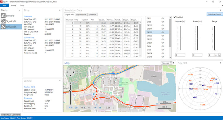
Specifically designed for testing GNSS interferences and cyber-attacks. QA707 has been designed to test robustness against emerging cyber-threats beyond jamming and spoofing. It allows the creation of scenarios with signal and code jamming, data-level cyber-attacks, denial of service threats, low-level spoofing channels control, and trajectory-controlled spoofing.
Optimal for signal modernization design. Being a flexible software defined radio (SDR) solution, QA707 is also suitable for testing of signal modernization and for the simulation of new signal components. An open API is provided to create specific signals simulation. Particularly, the tool is ready to support the upcoming Galileo Open Service Authentication (OSNMA).
Runs on a standard PC or laptop with USRP or other hardware. QA707 is compatible with several third-party hardware RF up-converters, including National Instruments’ USRP. It also can support customer’s specific hardware through the hardware API interface. Qascom introduces the new frontier of GNSS security testing. QA707 is supported from back office with custom services as well as jamming and spoofing mitigation solutions for receivers and applications. This covers 100% of customer GNSS security needs.
QA707 Main Features
Multi-constellation (GPS L1, Galileo E1, SBAS L1)
Galileo OSNMA ready
RF simulation, binary file dump, signal record and replay
Support to SDR platforms and open API for custom RF upconverters
The LabSat 3 Wideband is easy to use, cost-effective and produces extremely low noise, accurate and repeatable signals. Users can record and replay up to three different channels at 56 MHz with a bit depth of up to 3 bits I and 3 bits Q.
The following signals can be recorded and replayed:
2X CAN, RS232, and digital inputs recorded and replayed tightly synchronized with GNSS data
Small, battery or mains powered and with a removable SSD (up to 4 Tb), LabSat 3 Wideband allows detailed, real-world satellite data to be recorded then replayed on the bench. The rugged enclosure measures a compact 167 x 128 x 46 millimeters and weighs 1.2 kilograms, meaning it can be placed in a backpack and used to reliably record real-world signals in almost any situation.
SatGen Signal Simulation Software
If a user wants to simulate the signals from scratch, Racelogic’s latest SatGen signal simulation software can produce synthesized scenarios containing the full complement of popular GNSS signals: GPS L1, L2C, L5, GLONASS L1, L2, Galileo E1, E5, E6 and BeiDou B1, B2.
SatGen software allows users to quickly create accurate scenarios with their own time, place and trajectory, with any combination of constellation and signal that is currently available or will become available in the near future.
Precision-sensitive applications such as autonomous driving, control of unmanned aerial vehicles (UAV), or positioning of aircrafts during landing procedures in coordination with ground-based augmentation systems (GBAS) require that modern GNSS receivers undergo detailed tests before implementation.
Designed to generate highly realistic test scenarios, Rohde & Schwarz signal generators like the R&S SMW200A and the R&S SMBV100B offer a unique approach to generating complex and highly realistic scenarios for testing of GNSS receivers that are able to work with diverse navigational systems such as GPS, GLONASS, Galileo, BeiDou and QZSS/SBAS signals. The R&S SMW200A and the R&S SMBV100B can emulate them all for testing.
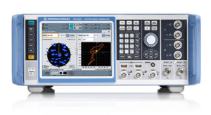
R&S SMW200A
The R&S SMW200A GNSS simulator (pictured above) can be used to produce complex interference scenarios with multiple interferers — all generated within the instrument itself. It can emulate up to 144 GNSS channels and can be equipped with up to four RF outputs. With its ability to simulate multi-constellation, multi-frequency, multi-antenna and multi-vehicle scenarios, the R&S SMW200A is able to cover a variety of high-end GNSS applications.
R&S SMBV100B
The R&S SMBV100B supports the same navigational systems, with access to 24 GNSS channels and one RF output, with the same ability to configure realistic scenarios including obscuration, multipath and atmospheric effects, as well as the specific characteristics of the antenna and the simulated vehicle. An integrated noise and CW interference generator can also be added.
Since the devices do not require an external PC for scenario configuration, all the tests can be created quickly through the user-friendly GUI. Due to all-encompassing instrument options available, both simulators can be set up to fit unique user requirements.
For testing GNSS receivers under controlled and repeatable conditions, the R&S SMW200A and the R&S SMBV100B provide extensive and cost-effective solutions. The platforms are ready to adapt to future requirements and testing of newly implemented GNSS signals.
SDX is a proven and advanced GNSS simulator based on GPU-accelerated computing and software-defined radio (SDR).
It is available as a complete turnkey system suitable for all GNSS simulation needs, including everything from compact test benches to complete CRPA test systems, such as SDX wavefront and SDX anechoic. Moreover, its software-defined roots enable the selection of cost-effective hardware into configurations that can be repurposed for different projects.
The architecture behind SDX provides real-time simulation of uncompromising accuracy. It features advanced signal customization and supports configurable outputs. IQ data can be generated in, or imported back into, the simulator as well. The API is embedded in the simulator core, enabling deep automation with a few simple clicks, as well as complex scripts developed with popular programming languages.
SDX simulates multiple constellations on multiple frequencies (GPS, Galileo, GLONASS, BeiDou and SBAS) on a large number of channels. Encrypted codes are supported for GPS and Galileo.
The Advanced Jammer module in SDX gives users complete control over interference creation. It is integrated directly into simulation scenarios to enable dynamic jammers (up to 120dB J/S) to interact with GNSS signals.
SDX also allows users to create advanced scenarios suitable for any type of vehicle: antenna patterns (receiver and GNSS SV), LEO/GEO/HEO orbits, multipath, hardware-in-the-loop (HIL), additive pseudorange errors, message modification and corruption, raw logging and more.
It is suitable for the design and validation of GNSS receivers, complex integration, academic research, NAVWAR and test engineering.
SDX is developed and actively supported by Skydel’s engineering teams and worldwide distributors. Skydel offers direct support to clients to ensure prompt deployment and integration, or to review advanced customization requirements.
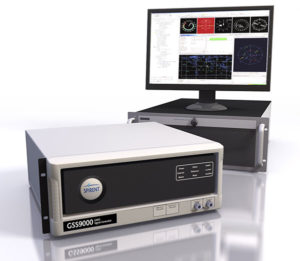
GSS9000, SIMMNSA, CRPA Test System, anechoic chamber testing, mid-range testing
Photo: Spirent
Spirent Federal provides GPS/GNSS test equipment that covers all applications, including research and development, integration/verification, and production testing.
GSS9000. The Spirent GSS9000 Multi-Frequency, Multi-GNSS RF Constellation Simulator is Spirent’s most comprehensive simulation solution. It can simulate signals from all GNSS and regional navigation systems and has a system iteration rate (SIR) of 1000 Hz (1 ms), enabling higher dynamic simulations with more accuracy and fidelity. The GSS9000 supports restricted/classified signals. Users can evaluate the resilience of navigation systems to interference and spoofing attacks, and have the flexibility to reconfigure constellations, channels, and frequencies between test runs or test cases.
SimMNSA. SimMNSA allows authorized users to simulate true M-code for the first time ever. SimMNSA has been successfully delivered to users of the GSS9000 series simulator. SimMNSA has been granted Security Approval by the Global Positioning System Directorate.
CRPA Test System. Spirent’s Controlled Reception Pattern Antenna (CRPA) Test System generates both GNSS and interference signals. Users can control multiple antenna elements. Null-steering and space/time adaptive CRPA testing are both supported by this comprehensive approach.
Anechoic Chamber Testing. Spirent’s GSS9790 Multi-Output, Multi-GNSS RF Constellation Wave-Front Simulator System is a development of the GSS9000. The GSS9790 is a unique solution providing the core element for GNSS applications that require a test system that can be used in both conducted (lab) and radiated (chamber) conditions.
Mid-Range Solutions. Spirent also offers solutions that cater to intermediate GPS/GNSS testing needs. The GSS7000 multi-constellation simulator provides an easy-to-use solution for GNSS testing that can grow with users’ requirements. The GSS6450 RF record & playback system enables replay of a real-world GNSS/GPS test repeatedly in the lab.
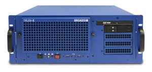
A scalable software-defined simulation platform powered by Skydel’s SDX, capable of generating high-fidelity GNSS and jamming signals simultaneously across multiple constellations and vehicles. Simultaneously simulate every signal below:
BroadSim’s software-defined platform includes intuitive user control and APIs; fast development cycles; flexible licensing and upgradability; and no additional hardware needed to maintain.
Forms
Original (4U)
Rack-mounted 4U simulator used for lab or field testing
4 RF outputs (unlimited jamming signals generated on 1)
1000-Hz simulation iteration rate
High-performance processor, GPUs and memory
Anechoic
Simulation system used for anechoic chamber testing
32 RF outputs and 16 dual-frequency antennas
Automatic antenna mapping
Automatic time delay and power loss calibration
Wavefront
Phase coherent simulation system
Real-time automated phase calibration
Scalable from 4 to 16 elements
Supports CRPA and multi-element receiver testing
Supports jamming and spoofing
Panacea
An automated PNT performance and vulnerability test suite that supports up to 32 UUTs (units under test) in real time, from test plan creation to post-test evaluation.
Time synchronization to live sky
Compatible with 100+ different GNSS receiver brands
Create dynamic scenarios with parameters such as jamming patterns, motions, power loss, delays and more.
Manages receiver communication and standardizes data output for easy analysis, visualization and reporting
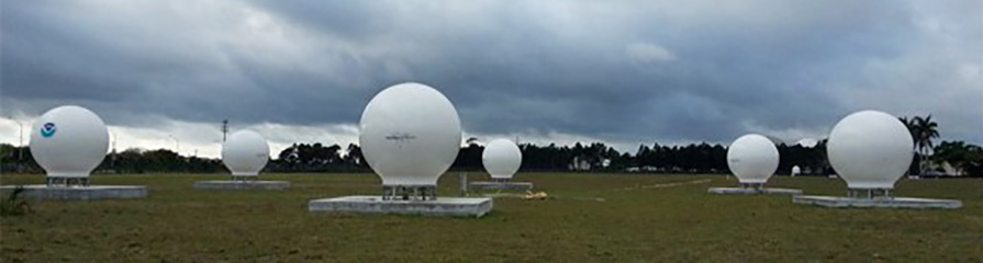
Orolia has successfully installed the first operational Cospas-Sarsat second-generation technology on search-and-rescue ground stations for the National Oceanographic and Atmospheric Administration (NOAA) in Florida and Hawaii.
The ground stations have been upgraded with second-generation beacon (SGB) signal-processing capabilities to more accurately and quickly locate the source of distress signals.
The NOAA Florida and Hawaii ground stations are the only operationally ready Medium Earth Orbit Search and Rescue (MEOSAR) ground stations in the world to receive the SGB signal specification capability.
The Cospas-Sarsat global search-and-rescue system developed specifications for the second-generation 406-MHz search-and-rescue beacon, which uses a modern, spread-spectrum signal to achieve more accurate and robust performance.
“The work performed by Orolia was exceptional, as the process of upgrading an operational system to a higher set of requirements, years after its initial design, involves minimizing downtime while validating the new requirements and revalidating the previous requirements,” said Mickey Fitzmaurice, NOAA SARSAT Systems Engineer. “The successful result makes it obvious that the engineering and operations team at Orolia put a great deal of time and effort into planning the upgrade, as the execution was seamless.”
“This series of world firsts demonstrates Orolia’s broad technical leadership in the global search and rescue ecosystem,” said Orolia Director of SARSAT Operations, Steve Ludwig. “We continually innovate to enhance the usefulness of these technologies, from generating encrypted beacon alert signals to including alert authentication through the use of Galileo Return Link Service.”
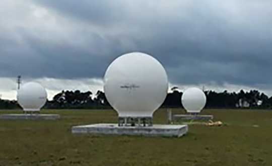
Cospas-Sarsat ground stations are called Local User Terminals (LUTs). These satellite receiving units are the ground stations that receive emergency beacon distress alerts. (Photo: NOAA)