Tag: Orolia

  • GMV uses Skydel SDX for GPS Week Rollover prep

    GMV uses Skydel SDX for GPS Week Rollover prep

    With Orolia's Skydel SDX API, GMV has developed a "Time Plugin" that allows to batch edit the numerical values associated to TGDs, UTCO, and Leap Seconds. (Image: GMV)
    With Orolia’s Skydel SDX API, GMV has developed a “Time Plugin” that allows to batch edit the numerical values associated to TGDs, UTCO and Leap Seconds. (Image: GMV)

    GMV uses the flexibility of Skydel SDX to simulate GNSS timing events.

    Blog by Ricardo Píriz, GMV, via Skydel Solutions

    The upcoming GPS Week Number Rollover (WNRO) on April 6 is a known feature of GPS that occurs only every roughly 20 years and thus can be anticipated and tested in a receiver using a GNSS simulator.

    A less-known rollover effect is also present in the Week Number (WN) associated to the UTC Offset (UTCO) transmitted by GPS. This WN has only 8 bits, which implies a range of values from 0-255, equivalent to a rollover every roughly 5 years. A possible failure in the receiver interpretation of the UTCO WN would not have such dramatic effects as a general GPS WNRO, but it could seriously affect the output of a GPS timing receiver.

    Other than WN rollovers, un-programmed GNSS timing glitches are extremely rare but not impossible. A well known case is the GPS anomaly of Jan. 25-26, 2016, when around half of the satellites in the constellation transmitted an incorrect UTCO value during 12 hours. The transmitted value was of the order of 13 microseconds, when the correct value is usually of the order of just a few nanoseconds. This caused many timing receivers around the world to provide an incorrect timing information or to fail altogether.

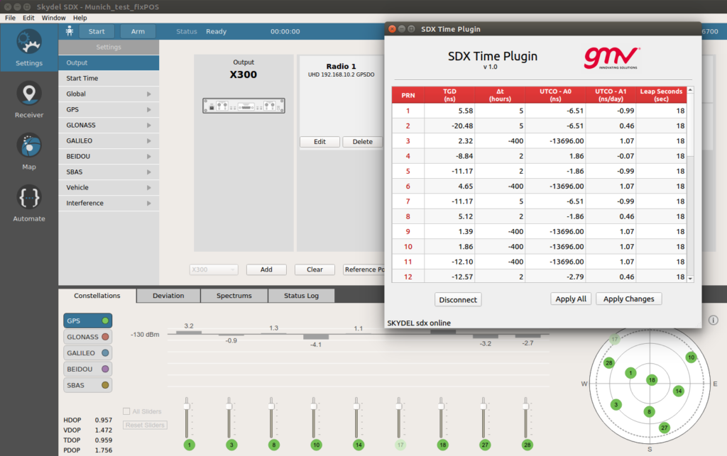
    Other fields in the GPS navigation message that could potentially be corrupt and cause incorrect timing output are Timing Group Delays (TGDs), and Leap Second information. In general, any event related to the contents of the GPS navigation message can be simulated by editing the associated bits in the message, for each satellite PRN.

    However this is a cumbersome and prone-to-error task. Orolia’s Skydel SDX simulator provides an Application Programming Interface (API) that allows to develop SDX extensions to tackle particular simulation problems in an easy and flexible way.

    By using this API, GMV has developed a “Time Plugin” that allows to edit directly on a user interface the numerical values associated to TGDs, UTCO, and Leap Seconds, per individual satellite PRN. These values are then converted to bits in the GPS message and transmitted in the RF stream to feed the receiver under test. Events like, for example, the GPS anomaly of Jan. 25-26, 2016, can be easily tested (as shown in the screenshot).

  • Orolia acquires simulation company Skydel Solutions

    Orolia acquires simulation company Skydel Solutions

    Acquisition Expands Orolia’s Global Footprint into Canada.

    Orolia has acquired Skydel Solutions, a GPS/GNSS signal simulation company based in Montreal, Canada.

    Orolia made the announcement at the Association of the U.S. Army’s Global Force Exhibition in Huntsville, Alabama.

    Orolia is a resilient positioning, navigation and timing (PNT) solutions company and a partner of U.S., NATO and allied forces. The company provides end-to-end resilient PNT solutions, including scalable, modular and cost-effective technology to support PNT-reliant and critical defense and commercial applications.

    Skydel’s capabilities allows Orolia to offer customers more diverse resilient PNT solutions with sophisticated testing and simulation protocols, additional customized signals, and superior vulnerability assessments for military and commercial applications where GNSS failure is not an option.

    According to Orolia, as the latest addition to the Orolia portfolio, Skydel brand solutions bring a new paradigm to the GNSS simulator scene by combining innovative algorithms and off-the-shelf hardware to help protect the world’s most critical GNSS-reliant systems operating through GPS, Galileo and other GNSS.

    Skydel technology also supports secure communications signals such as SAASM, M-code, PRS and other alternative signals with approved partners to provide real-world PNT vulnerability testing for critical infrastructure applications worldwide.

    “The need for continuous, reliable GNSS signals is growing exponentially worldwide, particularly for military and commercial systems that depend on accurate PNT data,” said Orolia CEO Jean-Yves Courtois. “The threats to these systems are growing too, whether it’s through signal jamming, spoofing or meaconing. With Skydel’s unique industry expertise, Orolia now offers even more rigorous, broad spectrum testing and simulation solutions to ensure continuous signals, even in GNSS-denied environments.”

    By combining graphics processing unit (GPU) accelerated computing and software-defined radios (SDR), Skydel-powered simulation solutions generate signals in real time, with uncompromising performance for demanding use cases. They are available as complete turnkey systems suitable for all GNSS simulation needs, including everything from compact test benches to complete CRPA test systems.

    “Since our inception in 2014, Skydel has enjoyed exponential growth,” said Stéphane Hamel, CEO of Skydel. “This strategic move with Orolia will allow us to keep our focus on disruptive innovation and accelerate our global reach.”

    Above: A montage of screenshots showing the various updates, from a February 2019 story about Skydel updating its SDX GNSS simulator to version 19.1 with Galileo Alt-BOC and more. (Image: Skydel)

  • Orolia launches Galileo-enabled personal locators in Europe

    Orolia launches Galileo-enabled personal locators in Europe

    The upgraded McMurdo FastFind 220 and Kannad SafeLink Solo Personal Location Beacons. (Photo: Orolia)
    The upgraded McMurdo FastFind 220 and Kannad SafeLink Solo Personal Location Beacons. (Photo: Orolia)

    Orolia’s McMurdo FastFind 220 and Kannad SafeLink Solo personal location beacons (PLB) now operate with the Galileo GNSS system.

    The PLBs are the first of a series of new solutions coming from the European Union-funded Helios project, led by Orolia, which has been set up to leverage the power of the new satellite system.

    With Galileo, the upgraded multi-constellation PLB receivers offer increased global coverage and support accelerated rescue missions. Location detection is enhanced and can be more precise as the PBLs receive coordinates from the Galileo satellite network in addition to GPS. Signals can even be detected in high-sided locations, such as canyons.

    “We are thrilled to be launching our upgraded PLBs in the European and U.S. markets,” said Chris Loizou, vice president of maritime at Orolia. “The combination of both Galileo and GPS GNSS capability means that our customers will benefit from coverage that spans from the North to the South Pole. We work tirelessly to push the boundaries of product innovation and, ultimately, to give people the best chance of being rescued in an emergency situation.”

    The McMurdo FastFind and Kannad SafeLink PLBs are part of Orolia’s comprehensive search-and-rescue ecosystem and join the McMurdo SmartFind G8 and Kannad SafePro series EPIRBs as Galileo-capable rescue beacons.

  • Spain and Australia commission Orolia for Sarsat

    Spain and Australia commission Orolia for Sarsat

    Orolia’s LEOSAR-GEOSAR-MEOSAR (LGM) Mission Control Center (MCC) solutions are now commissioned as Nodal MCCs in Spain and Australia, enabling global distribution of critical search-and-rescue information through the Cospas-Sarsat system.

    With the successful commissioning of their Nodal MCCs, Spain and Australia will now be able to share critical information with the U.S. and France, providing worldwide coverage for global search and rescue.

    In addition, since they will be authorized to commission other MCCs in their regions, they will also significantly advance the Cospas-Sarsat MEOSAR program.

    Orolia’s McMurdo PRISMA MCC features satellite search-and-rescue technology with full LGM capability. It is the commercial solution of choice for search-and-rescue authorities in Norway, the UK and many other countries.

    “We’re proud to support the world’s most critical search and rescue operations,” said Steve Ludwig, Orolia’s director of SARSAT Operations. “With Orolia onboard, you can rely on proven solutions in critical environments where failure is not an option. Our PRISMA Mission Control Center systems are the only successfully deployed, Cospas-Sarsat commissioned commercial solutions available, meeting the highest standard for search-and-rescue support.”

    The Orolia PRISMA Mission Control Center. (Photo: Orolia)
    The Orolia PRISMA Mission Control Center. (Photo: Orolia)

    Orolia has been developing global search-and-rescue programs for nearly 30 years, reaching a major milestone with the Medium-altitude Earth Orbit Search and Rescue (MEOSAR) system in 2011, and completing all global MEOSAR system installations since.

    To date, 75 percent of the Earth’s surface is monitored by Orolia’s MEOSAR systems.

    Through its McMurdo brand, Orolia has equipped these systems with the latest search-and-rescue technology to increase response times and save more lives worldwide.

  • Prepare today for timing disruptions tomorrow

    Prepare today for timing disruptions tomorrow

    When a Pennsylvania county’s 911 system suddenly went down without warning, garbled messages across the network impacted fire and police agencies’ ability to respond to emergency messages. The issue was traced to a firmware malfunction on communications equipment, related to provision of GPS timing. The firmware had not been updated for 19-1/2 years. Why should it have been?  Everything was working fine — until it didn’t.

    Test lab set-up. Photo: Orolia
    Test lab set-up. Photo: Orolia

    In addition to increased jamming and spoofing threats, GPS has a “week rollover event” set to happen in April 2019. If the GPS receivers found at the heart of many critical systems do not handle this properly, any number of failures can occur.

    Without GPS timing, everything slows down, has less capacity and becomes more dangerous.

    This Thursday, a complimentary webinar outlines test plans for GNSS equipment used in critical timing applications, discusses the need for assured access to accurate timing across financial institutions, industrial automation, telecommunications, transportation, the power grid and elsewhere — and defines just what “assured” access means and how crucial the “assured” part is — and finally reviews some recent mishaps and near-disasters caused by interrupted or inaccurate timing.

    Speaking on the 1-hour webinar are Lisa Perdue, product manager and applications engineer, Orolia; Stefania Römisch, leader, the Atomic Standards Group at the National Institute of Standards and Technology; and Dana Goward, president, Resilient Navigation and Timing Foundation.

    Following each speaker’s 12- to 15-minute slide presentation, a live Q&A period with the audience will explore particular issues and concerns.

    The webinar, taking place 1 p.m. ET Nov. 15, is sponsored by OroliaRegister here (free).

  • Roll over, Eindhoven. And tell tectonics to move.

    Roll over, Eindhoven. And tell tectonics to move.

    A free lesson for those in charge of critical infrastructure systems such as the power grid, communications, financial markets, emergency services, and industrial control.

    Many of these systems have functioned smoothly and efficiently for years, thanks to the precise timing provided by GPS receivers. That could change, suddenly and without warning, if predictive and preventative steps are not taken.

    The GPS receivers somewhere near the hearts of these critical systems, if not thoroughly vetted, tested and checked for up-to-dateness, could constitute a vulnerability — a vulnerability that would be catastrophically exposed on April 6, 2019. In 6 months’ time.

    Image: Orolia
    Image: Orolia

    The GPS constellation transmits the proper date and time to all receivers, worldwide, by supplying the current week and the current number of seconds into the week. This enables the receiver to translate the date and time into a more typical format: day, month, year, and time of day. Infrastructure systems use the precise timing to synchronize many complex operations across their respective networks. Critically, the field that contains the week number is a 10-bit binary number. This limits the range of the week number to 0 – 1023, or 1024 total weeks.

    GPS week zero started January 6, 1980. The 1,024 weeks counter ran out and rolled over on August 21, 1999. The week counter then reset to zero, and it has been recounting ever since. The next time the counter will reach week 1,023 and roll over to zero is on April 6, 2019.

    If the GPS receiver is new or has received firmware updates, it can accommodate and adjust for this change. But do you know for sure? Only if you test. Otherwise, your critical systems may go into a time warp, 19.7 years out of date. Visualize that discrepancy rippling outward from the core component of a critical timing system throughout your infrastructure. Or, simply not working at all.

    It is incumbent upon all managers to verify that such an issue will not occur — well before its possibility arises. At a minimum, experts recommend consulting your receiver manufacturer to confirm that the issue has been fully tested and will not occur. Many manufacturers have already issued compliance statements, and are expected to continue doing so over the next year, up until the event occurs.

    To be sure that your system will not experience any failures related to this issue, it is possible to test for this event using a GPS/GNSS simulator. The requirements for the simulator are straightforward. The basic yet key information necessary to undertake such testing will be communicated in a free webinar on Thursday, November 15.

    The panel of expert speakers includes Lisa Perdue, product manager and applications engineer, Orolia; Stefania Römisch, leader, the Atomic Standards Group at the National Institute of Standards and Technology; and Dana Goward, president, Resilient Navigation and Timing Foundation.

    You may register for this free webinar here, to attend it live or download it for later viewing at your convenience.

    Here is a useful reference from the last time the rollover occurred, with a mention of the next one.

    Photo: Technical University of Eindhoven
    Photo: Technical University of Eindhoven

    Eindhoven, the Netherlands, is home to the Eindhoven University of Technology, an incubator for technology startups where many scientists active in GPS research and in the direction of the Galileo satellite navigation program have trained.

    Tectonics is the study of plates in the Earth’s crust that move in different directions and speeds. To study plate motion, GPS instruments are anchored firmly in bedrock to measure how it moves, infinitesimally yet measurably, thanks to the nanosecond timing provided by the GPS constellation and interpreted by properly calibrated and updated instruments.

    Roll over, Beethoven.

  • Thank you for registering.

    Thank you for registering for the upcoming webinar, “Protecting Time-Sensitive Critical Infrastructure Systems,” brought to you by Orolia.

    A link to the live event will be sent to you two hours before the event. Your personalized event URL will be automatically generated by the ON24 system. To ensure receipt of the email, please whitelist this email address by adding it to your contacts: [email protected].

    This presentation will begin on at 1 p.m. EST /  10 a.m. PST on Thursday, Nov. 15.

    Audience members may arrive 15 minutes prior to live time. If you have any questions, please contact event producer Allison Barwacz at [email protected].

  • Orolia launches Horizon search-and-rescue system

    Orolia launches Horizon search-and-rescue system

    Orolia has introduced the McMurdo Horizon system, an S- and L- band compatible phased array system featuring antennas developed by Ball Aerospace with horizon-to-horizon coverage to capture search-and-rescue signals relayed from orbiting satellites immediately after line-of-sight is established.

    The McMurdo Horizon system is now available to enhance regional search and rescue services worldwide with technology to complement existing and emerging ground-based systems at Medium-altitude Earth Orbit Search and Rescue (MEOSAR)ground stations.

    Orolia’s McMurdo Horizon Medium Earth Orbit Local User Terminal (MEOLUT) can deliver enhanced search and rescue coverage and second-generation signal processing capabilities, in a compact form factor with no moving parts. The key technology innovation, based on a modified off-the-shelf phased array antenna developed by Ball Aerospace, is a custom-designed Orolia solution.

    By pointing to satellites near the horizon, the McMurdo Horizon MEOLUT can detect and locate emergency beacons much farther away. This enhanced detection ability, combined with the McMurdo Selective Schedule Algorithm, enables the system to monitor more diverse regions, including the translation of oblong and irregular data points that are invisible to traditional systems.

  • Orolia introduces SecureFind wearable combat search-and-rescue beacon

    Orolia introduces SecureFind wearable combat search-and-rescue beacon

    U.S. Army photo by Spc. Javon Spence
    U.S. Army photo by Spc. Javon Spence

    Orolia has introduced its latest military technology innovation, the SecureFind Combat Rescue Beacon, at the 2018 AUSA Annual Meeting in Washington, D.C.

    In addition to protecting the most critical assets and leaving no one behind, combat search and rescue (CSAR) technology can significantly enhance military operations by avoiding the loss of sensitive information and technology, avoiding hostage situations and helping to prevent conflict escalation.

    SecureFind is based on Orolia’s search-and-rescue technology suite, selected by military forces for CSAR missions. The wearable base unit includes an open channel search-and-rescue solution, for military use in training or test mode. It can also be configured with a customer-defined, secure channel solution for covert operations.

    The versatile CSAR solution operates with a silent, push-button functionality that does not require voice activation. SecureFind enables military forces to precisely and safely execute CSAR missions, with optional Assured PNT (positioning, navigation and timing) technology that prevents GPS signal interference, spoofing and jamming, the company said.

    “There is no greater need for urgency, stealth and precision than when military personnel are isolated in rugged environments or behind enemy lines,” said Paul Zweers, Orolia’s vice president of defense programs.

    “Software-defined, wearable communications technology is now more important than ever on today’s air, land, sea and cyber battlefields,” added Orolia CEO Jean-Yves Courtois. “CSAR missions are just the beginning of potential uses for this resilient military technology, which can ensure reliable positioning, navigation and timing data in any operating environment. Orolia’s solutions are tailored to support today’s soldiers and engineered with a view toward the future of global military networks.”

    According to Orolia, the standard SecureFind solution is available at a price point that could enable thousands of warfighters to benefit from the new battlefield technology. More advanced functionality is also available, such as the ability to change signals on-the-go for additional security, to detect and mitigate GPS jamming and spoofing, and to generate important strategic information such as virtual battlefield maps of jamming and spoofing activity.

    Orolia offers a cost-effective, modular approach to assured PNT, with a flexible, open architecture that integrates easily with legacy systems. This layered platform meets critical technology requirements without over-engineering a solution that is complex, expensive and difficult to maintain.

    Additional SecureFind product information is available at the AUSA Annual Meeting, Orolia booth #8051.

  • Q&A on challenged PNT

    Q&A on challenged PNT

    This editorial comes to you live from the control console of GPS World’s June webinar, “Defense PNT in Challenged Environments.”

    I’m impressed, as always, by the engagement of our webinar audience. Questions are pouring in about the speakers’ presentations, in addition to knowledgable queries submitted before the webinar began. These events strike me as, hour for hour, the best professional education one can get, short of leaving the office for a week to attend ION GNSS+ or the institute’s other conferences through the year, or the European Navigation Conference or Intergeo or others of the like. And a webinar takes only an hour of your time! From the comfort of your desk! Or sofa, even.

    Here are some of the questions posed, and brief digests of our experts’ answers. The panel included John Fischer, VP Advanced R&D at Orolia, assisted by Jon Sinden, product manager for Rugged PNT; Tim Erbes, CTO at Talen-X; and Carol Politi, CEO at TRX Systems.

    Q: Role of Galileo Public Regulated Service (PRS) in GPS-disrupted environment? Particularly given NATO alliance and cooperation? Any more detail about use of other GNSS to make solution more robust?

    A: The PRS is certainly low-hanging fruit for traditional partners to take advantage of both GPS and Galileo, and I imagine fielded solutions will soon start to show that. There are substantial benefits to be gained from use of other GNSS as well.

    Q: Please discuss the hardened military aspects of coming GPS III signals and codes. How will the new GPS III constellation impact your products?

    A: Block III alone is not enough to make this happen. A new M-code will eventually replace the SAASM M-code, and it will provide a true separation from the civilian signal, different from the current situation with M-code and C/A code. Already, a dozen or more IIF satellites are now transmitting it. But the upgrade has to happen in three places for it to become effective: the satellites, the user receiver — and this is a complex, extremely broad and varied picture in the military realm — and finally the ground control system. There have been some difficulties in deploying the new OCX. This is the biggest determining factor of when these new features will roll out.

    Q: What is the potential role of other means of PNT: eLoran, Iridium STL, lidar, and so on?

    A: ELoran a very good alternative, ideal from the point of view of diversity: terrestrial instead of satellite, high-power instead of low, other end of spectrum from GNSS. Orolia published a white paper on a holistic approach towards resilient PNT, discussing eLoran and STL; see our website.

    There are additional opportunities for outside-the-box solutions, for example, the sensors aboard tanks for anti-missile defense systems. They could also be used for PNT. Networked data radios for crowdsourced PNT data.

    And there’s more! See gpsworld.com/webinars to download the webinar and get it all.

  • New speaker added for June 21 defense PNT webinar

    Carol Politi, CEO of TRX Systems, has just joined the panel of speakers who will address a range of defense and security issues with GPS and GPS denial during a free webinar this Thursday, June 21. Politi will discuss low SWaP sensor and RF technology for supporting continued operation within denied areas and dismount operation within a broader system of systems PNT context.

    She joins John Fischer and Jon Sinden of Orolia, who will focus on “Protecting GPS-Reliant Military Systems,” and Tim Erbes of Talen-X, an expert in GNSS simulation and threat mitigation technologies, for “Defense PNT in Challenged Environments.” Register for the webinar here.

    TRX Systems delivers mapping and location for dismount personnel location in areas without reliable GPS, including indoors, underground and where GPS is intentionally denied, for the defense, public safety and industrial markets. Politi holds multiple patents for innovations related to control of mobile devices and collaborative creation of indoor maps, received her M.S.E.E. from Johns Hopkins and B.S.E.E., MBA from the University of Maryland.

    The company recently showcased the latest updates to its NEON Personnel Tracker for the 10,000 defense industry professionals at the Special Operations Forces Industry Conference. NEON is an enterprise-class 3D mapping and tracking Android application tightly integrated with a suite of algorithms fusing inertial sensor data, Bluetooth and Wi-Fi readings and inferred map and building data to deliver reliable 3D location. Personnel wearing a small, NEON Tracking Unit and carrying an Android device can now be tracked and located in real-time and for after action review.

  • Webinar confronts land warfare’s reliance on GPS

    Webinar confronts land warfare’s reliance on GPS

    A U.S. soldier preparing his Blue Force Tracker before departing Camp Victory, Iraq in 2005.
    (Photo: Petty Officer 1st Class Brien Aho, U.S. Navy)

    A free GPS World webinar, sponsored by Orolia and taking place at 1 p.m. EDT on Thursday, June 21, will discuss “Defense PNT in Challenged Environments.”

    The webinar will consider the reliance on GPS in modern land-warfare systems, as well as the potential effects of GPS disruption on their operations and ways to protect their ability to continue operating in a GPS-disrupted environment.

    John Fischer, vice president of advanced R&D at Orolia; John Sinden, product manager for rugged PNT at Orolia; and Tim Erbes, CTO at Talen-X, will present during the webinar. GPS World Editor-in-Chief Alan Cameron will moderate it.

    Fischer, who has worked with global navigation satellite systems, wireless, positioning navigation and timing at Orolia for more than 15 years, will highlight protecting GPS-reliant military systems during his presentation. Fischer will also discuss considerations for protecting land-warfare systems’ ability to continue operating in a GPS-disrupted environment from jamming, spoofing or environmental interference.

    Register for the webinar here.