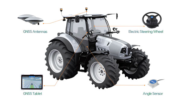
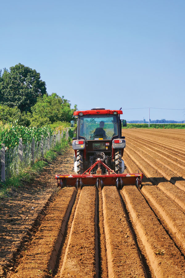
ComNav Technologies has introduced the AG502 automated steering system. It integrates advanced satellite reception, positioning, navigation and automatic driving to meet the diverse demands of modern agriculture.
The system consists of a GNSS tablet, an electric steering wheel, two angle sensors and two GNSS antennas, offering a plug-and-play capability with simple instillation and calibration. It is equipped with a ComNav SinoGNSS to support full-constellation and multi-frequency tracking.
It is designed to withstand harsh outdoor agricultural environments. With waterproof and dustproof properties, the system offers weather resistance and durability in diverse conditions.
The AG502 is equipped with connectivity modules, featuring a 4G modem alongside UHF radio. It offers farmers the flexibility to access real-time kinematics (RTK) correction sources from local RTK networks or GNSS RTK base stations. It uses the combined GNSS+INS terrain compensation technology to provide automated steering accuracy, with a precision of 2.5 cm. This level of precision makes the system ideal for tasks such as ditching, planting and harvesting.
For the remotely located or often network-lacking fields, the system offers a reliable precision point positioning (PPP) solution, which supports PPP-HAS and PPP-B2b service. It also features intuitive and user-friendly 2D/3D software, streamlining the learning and operation process for easy start-up. It supports various work modes such as straight, curved, automatic u-turn and pivot to accommodate diverse farmland and work requirements.
ComNav offers comprehensive training videos of the AG502. In the event of technical challenges, users have access to remote technical support or can reach out to local dealers via phone, email or messaging apps for prompt assistance.
Septentrio has released the AntaRx-Si3, a GNSS/INS smart antenna housed in an ultra-rugged enclosure, designed for straightforward installation on machinery such as agricultural robots. It combines Septentrio’s centimeter-level GNSS positioning with an inertial measurement unit (IMU) within the same enclosure as the GNSS antenna, which uses FUSE+ technology.
The AntaRx-Si3 is designed for challenging industrial environments where GNSS signals are at risk of obstruction, such as under heavy foliage. The integration of the IMU sensor with FUSE+ technology offers continued position availability accuracy and reliability, which is necessary for autonomous systems’ operations.
The antenna’s exterior is crafted from impact-resistant polycarbonate with an IP69K rating and can withstand significant shocks, vibrations, and harsh environmental conditions.
It uses Septentrio’s GNSS+ algorithms to offer advanced multipath mitigation to operate in environments where satellite signals could be reflected off surrounding machinery or structures, such as silos. The antenna delivers high update rates and low latency positioning, which are crucial for the control loops of autonomous movements or rotations.
I asked Jason O’Flanagan, co-founder and CEO of Seirrowon Labs — which specializes in robotic vehicle control, electronics hardware and firmware development — about the company’s collaboration with u-blox on precision agriculture.
What is your background and your company’s origin story?
I’ve been doing precision agriculture for 25 years. I started with Beeline, which was the first company to do automated steering of agricultural equipment, late in the last millennium. I worked for many of the big OEMs, including Kubota and AGCO. I saw an opportunity for GNSS solutions and products. Obviously, there’s a lot of competition there, but we wanted to focus on fixed row crops and orchards because GNSS does not work well in an urban canyon-type scenario. So, there was a niche there for us to jump on.
Were you the company’s co-founder?
Yes, I am one of the company’s co-founders. The company’s name, Seirrowon, is actually “no worries” spelled backward.
I know that you’re working with u-blox.
We’re using both hardware and services products from u-blox. We’re using both their normal RTK receiver and their sensor fusion GNSS receiver. We started looking at u-blox, NovAtel, Trimble and Septentrio. However, we settled on u-blox as its mix of services and hardware were the best suited to our business model. They provide a fully unlocked, fully functional receiver out of the gate.
In the fixed crop, orchard situation, having as many satellites as possible really helps with your position. So, from a hardware standpoint, it was a perfect solution for us. It allowed us to track up to 85 satellites (two channels each) at a time in adverse conditions. Their sensor fusion version, which is their ZED-F9R, allowed us to fill in the gaps when the GNSS became unusable under the tree foliage. The SL LITE is a generic RTK receiver and the SL LITE-R includes sensor fusion and the SL Pro uses their L band receiver with the sensor fusion module.
What value do you add to u-blox’s modules?
All they give us is the raw GNSS. We add some IP functionality and support. U-blox outputs its data in a certain format, which is not really applicable to the ag industry. So, we map out the data to get it in the right format that will work for a lot of the equipment that’s in the marketplace.
Second, we added a support server to it so that it backs up its settings to a remote server. So, if customers go down, we can flash their replacement receiver and overnight them back to them. The customers are also able to turn on remote support where we can see the data from the receiver and diagnose issues remotely. Our dealers have the same access.
We’ve added a support mechanism into our hardware that allows for better remote support without having to wait hours for someone to get to the field or diagnose an issue. We’ve also added remote updating for support and software. So, the customer can update and add new features remotely without us having to send someone out to do that.
Basically, what ag uses violates several of the NMEA conventions. For example, NMEA limits the number of satellite outputs to show 12, but in the ag world all GNSS receivers output the actual number of satellites, using the correction in the NMEA 183 message.
How does the NMEA data format differ from what’s need in agriculture?
Raw GNSS is not sufficient for an active moving solution. Regardless of what GNSS supplier we ultimately chose, the solution provided in GNSS via raw NMEA was not suitable for autonomous or mapping applications by itself. We spent a great deal of time tweaking our output to be best solution possible. This included adjusting for time, terrain and movement. Senor Fusion introduced its own unique issues that we worked through to create the best working solutions. I have spoken to several companies that tried to implement GNSS solutions expecting the raw modules and boards to work out of the box and have been left with a bad taste in their mouth.
In general terms the NMEA 0183 Standards for GGA and VTG don’t have the accuracy required for RTK/PPP performance without violating the length of string limit. We added some additional information to the GGA message to help diagnose issues with performance without needing extra logs and data to see performance. While this does not meet the NMEA 0183 spec it is mostly ignored by Ag equipment downstream. We are currently working with the AgGateway Organization to better use the NMEA spec for use in agricultural applications.
Who stores, aggregates and analyzes the data collected?
We’re not actually taking any position data. We’re just taking GNSS performance information, and the customer must opt in for that. So, it’s defaulted off; if the customer turns it on, it means that we get a complete set of their settings backed up to a server that we own. We have a server with a backup server. So, it comes to our server, and it’s just a just a general setting information that we’re using, and some performance information on satellite tracking, and other things that help us diagnose issues with the receiver. It’s not performance information as far as their location or how they use the receiver. It’s more diagnostic information only.
What is involved in installing your equipment on tractors, combines, sprayers, and so forth? What kind of support do you provide? I assume that you’re brand-agnostic.
We designed our receiver so that anyone can install it. We took a lot of the complications out of it. We use industry standard Deutsch connectors and our device’s user interface is HTML. So, you can use any smartphone or laptop or any device that has WiFi in it to set up the device. There’s no special software required, there are no special cables; you just connect to it as if were a hotspot. You can actually set it up completely from there.
We’ve simplified everything to make sure that users don’t need a degree in GNSS or in engineering to install the receiver. It’s very straightforward. It has several pre-configured profiles within it that allow you to take a generic setup and say, “Hey, I’m putting you here,” so it will default to all the correct settings. We really want to make it as simple and straightforward as possible.
How does it interface with the machine’s steering control?
To interface with the vehicle, we use standard NMEA 0183. We have all the hardware for NMEA 2000 CANBUS but that will come in early 2024.
So, typically, growers just buy the device and have one of their team members put it on?
We normally sell through dealers and OEMs. They incorporate it into their solution. For example one of our dealers uses a system called Weedit. Basically, the distributor incorporates that receiver into each scenario that they have. They must record all that information for EPA in California, so they know exactly what chemicals they put where. So, GPS becomes incredibly important within those orchards to know exactly where the chemical was applied, because they must submit that information.
So, the dealer does the integration onto the machine?
The OEM. However, it is available as a drop-in replacement for any of the old legacy receivers such as Raven receivers that fail over time and some of the other older equipment. So, a general customer that uses Raven equipment can put our receiver in to replace it. I’m just using Raven in this example because it’s a US company that has basically disappeared.
So, it’s not factory-installed and it’s not usually installed by the user, but the dealership put it onto a machine before selling it?
We have dealers and distributors, but it can be installed by an end user as a replacement for a failed old piece of equipment.
Is any of our equipment factory-installed?
No. Not with the big guys anyway. They’re all tied up with their own GNSS at the moment. AGCO is in a pending joint venture with Trimble, CNH Industrial has bought Hemisphere GNSS and Deere has its own offering. So, the big guys all have their own GNSS solutions for now.
The consolidation in the industry is very interesting. I find it curious that in some of the mergers and joint ventures are combinations where both parties already have similar offerings.
Perhaps it’s still evolving.
It sounds like it’s still in the early phases of agreement.
What is the typical use case for your technology?
We have a generalized solution, that would be equivalent to, say, a SMART7 from NovAtel. It’s designed for row crop work out in the field and functionality within the standard operations that you get for GNSS receivers within agriculture. Our offering includes the LITE, which is a generic RTK receiver, and the LITE-R and PRO, which use active sensor fusion to allow us to function better in orchards and fixed crops that have obstructions to the sky.
I’m concentrating on the orchards and fixed crop market because none of the main OEMs that are out there doing GNSS are taking any time with that market, so that’s where we see our niche.
I looked after all the North American support and product direction when I was at AGCO and there was nothing more frustrating than having a product that was complicated to use, difficult to set up, and required multiple people to touch it to make it work. With that in mind, we developed our products to be very simple, very straightforward, able to diagnose most of their problems by themselves, and as functional as possible without having to have someone go out and spend time on diagnosing issues. Our devices are intelligent enough to do that. While generating our product, and putting it into the marketplace, we have spent a lot of time thinking about how to support our customers by avoiding complications and downstream issues.
What else differentiates your company from your competitors?
We have PPP correction services from both satellites from the Internet — similar to services provided by Trimble and NovAtel. However, the industry standard is to only offer a three-month or 12-month subscription, while we offer it monthly. So, you can actually activate it with a phone on the device, purchase a one-month subscription and just use it in the months that you need it. So, a farmer who needs it for only two months in the spring and three months in the fall can pay for only those months instead of having to pay for the whole year. We’re trying to make it as usable and as targeted toward farmers as possible. Through Pointperfect from Ublox. We sell this under our brand name of Flat Earth PPP. (We thought this was a funny name that makes fun of the flat earther movement given that GNSS works because the world is a sphere.)
What else distinguishes your products?
Our receivers are completely unlocked and ready to go out of the gate, without nickel and diming customers or holding features back from them. When they pay for the system, they get everything. If you are going to unlock a feature on a NovAtel or Trimble receiver, you have to get back to the dealership, they then have to use some e-commerce system to purchase that Auth code, then they either give the customer this huge, 64-character code, or someone has to come out and make that change. We don’t have to do any of that. Everything’s unlocked and ready to go.
Our use case is focused on a low profile, a small footprint, and a ruggedized enclosure. We came up with a unique design of antenna that resulted in reduced size without losing any performance. As a result, our receiver is only 35mm tall, 100mm wide and 180mm long. We have filed a patent on this unique design. We also designed it for most agricultural environments by having protection on all IO and the ability to be powered from 9-36V to meet the requirements of both US and European agricultural applications.
Because of the low-profile requirement, we needed a receiver module that is mounted to the board directly instead of a separate receiver board that would have made the enclosure taller.
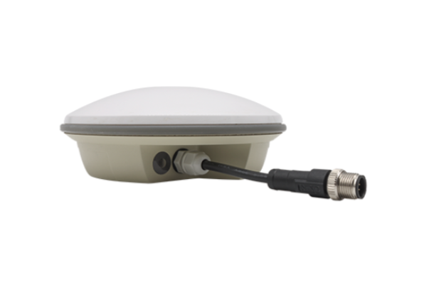
CHCNav’s NX510 SE GNSS RTK auto-steering system helps growers achieve the precision required for specialized planting operations. (Image: CHCNAV)
CHC Navigation’s NX510 SE GNSS RTK auto-steering system helps growers around the world achieve the precision required for specialized planting operations.
Intercropping. Growing two or more crops together in the same field, known as intercropping, is a sustainable and effective agricultural practice that is being adopted worldwide to increase yields. It is a bit counter-intuitive because it forces the different crops to compete for water, light, and nutrients. However, if the plants are carefully selected, their seeds are correctly spaced, and their growth is properly managed, it can be a recipe for success. For example, legumes, such as soybeans, which are good at nitrogen-fixing, can provide nitrogen to corn, thereby reducing the need for additional nitrogen fertilizer and the concomitant risk of chemical runoff. Mixing these two plant species also increases biodiversity and ecological stability. However, if the seeding is not planned carefully and executed precisely, the corn’s tall stalks will shade the soybeans’ short stems and reduce their yields.
Mr. Chen, a farmer and president of Agricultural Machinery in Anhui, China, co-crops corn and soybeans in the same field. To seed them precisely, he relies on CHCNAV’s NX510, which has a pass-to-pass accuracy of ±2.5 cm. Prior to using an automated steering system, his yields suffered because his seed rows were not straight. The system makes planting a simple task: the operator sets the row spacing for crops and the tractor automatically maintains it. Operators can also share those patterns among multiple farm machines, greatly increasing efficiency.
Growing rice. About half of the world’s population — especially in Asia, South America, and sub-Saharan Africa — relies on rice as its staple food. China is consistently ranked among the top 10 rice-producing countries due to its ability to cultivate it during two to three rice-growing seasons per year. Rice farmers around the world share challenges, including resource depletion due to soil degradation, urbanization, the effects of climate change, and a shrinking labor force, especially skilled labor.
Every rice planting season is a race against time and requires optimizing efficiency, including executing precise, straight-line planting operations to accurately align the new rice crop with previously established rows of seedlings. Any inaccuracy can sharply reduce rice yields. This is a key concern in China, which has only 0.02 hectares of rice land per capita. It is also vital to achieve sustainability and minimize environmental impact.
In a recent application, the NX510 has been successfully integrated into rice transplanters used to plant rice seedlings in swampy soils in China. It ensured that rice seedlings were planted at consistent depths and in the correct vertical and horizontal positions, promoting adequate ventilation and optimal light exposure for their subsequent growth.
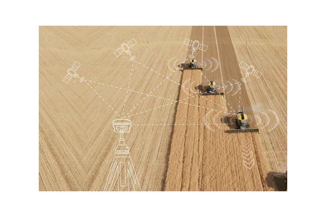
NX510 SE. The NX510 SE utilizes five satellite constellations — GPS, GLONASS, Galileo, BeiDou and QZSS — and multiple correction sources, including 4G RTK networks and UHF RTK stations. Its built-in 4G and UHF modem connects to all industry-standard DGPS and RTK corrections and its terrain compensation technology maintains high accuracy even in challenging environments and terrain. The receiver’s 10.1-inch industrial display, operating on the AgNav multilingual software, supports multiple guidelines patterns, including AB line, A+ line, circle line, irregular curve and headland turn, to handle all common farming operations.
The NX510 autosteering system delivers significant productivity gains at a cost accessible to nearly every farm, making it suitable for retrofitting old and new farm vehicles. An additional advantage of autosteering is that it enables growers to maintain the same high level of accuracy when operating at night, which is often required to escape the oppressive daytime heat or to meet tight schedules.
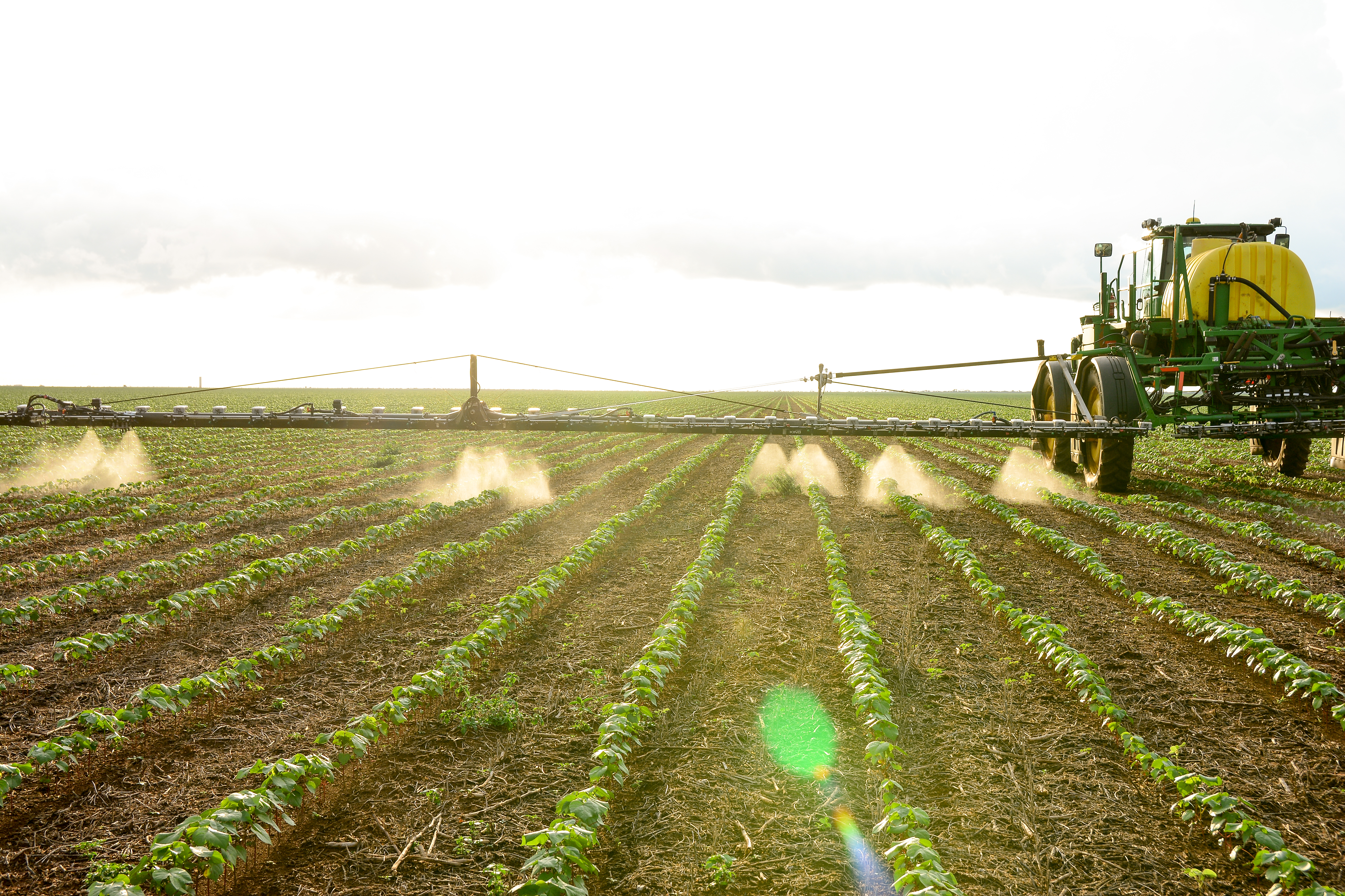
Trimble’s WeedSeeker 2 automatic spot spray system uses advanced optics and processing power to detect and eliminate resistant weeds. (Image: Trimble)
In September 2023, Trimble announced an agreement to form a joint venture (JV) with AGCO “to better serve farmers with factory fit and aftermarket applications in the mixed fleet precision agriculture market.” I discussed the announcement with David Britton, vice president of product management, Trimble Agriculture.
Your press release says “Trimble and AGCO’s shared vision is to create a global leader in mixed fleet, smart farming, and autonomy solutions.” What does mixed fleet mean in this context?
That’s focused on the farmers’ ability to use any brand of tractor or implement together. As you can imagine, there are multiple OEMs in the market. One of the beliefs that Trimble’s had, and that AGCO shares, and why this JV makes sense, is that the farmers’ decisions around what technology they use and the way that their farms operate shouldn’t be inextricably tied to the brand of tractor that they use.
So, they could use an AGCO tractor, but with a GNSS receiver that’s not from Trimble or vice versa?
More so that on their farm they could have equipment from AGCO and other OEMs. In many cases, they’ll have more than one tractor and multiple different implements.
Those machines can talk to each other and share the data.
Ideally, yes.
Image: Trimble
What will be the division of labor between Trimble and AGCO? How will the interface work?
The JV will not be involved with any of the tractor manufacturing, which will stay within AGCO. We’re going to be focused on the precision ag technology that will go into the tractor, help manage the implements, and complete the work, as well as the data systems that underpin that.
Currently, Trimble Ag has capabilities on embedded display software that are used to help manage activities in the field and steer the vehicle. We also have cloud software that allows farmers to manage their information and data and work with other people in their ecosystem, as well as many other things. That’s all going into the JV. Trimble will supply GNSS technology to the JV, which is a foundation to enable geolocating the information in the activities.
Then you have JCA Industries [which AGCO acquired in 2022] that has been focused on implement control and autonomy. So, the two businesses are complementary. They are coming together to focus on higher technology components and then work with both AGCO as well as other manufacturers and the aftermarket to deliver smart farming and autonomy solutions into the farm to help farmers run their businesses and farms more efficiently.
Tell me more about the aftermarket.
One of the key things that we’ve seen historically, and we expect the trend to continue, is that you’ll see innovation happen in the aftermarket first, because it gives a chance to rapidly iterate and learn before you go through the process of putting it into the factory. We expect that we’ll have a very healthy aftermarket business, as well as a portion of the business where our technology will be factory-fit into machines from both AGCO and other manufacturers, because that’s been an important part of the Trimble business. Being able to work with other OEMs to provide important technologies will be a part of that story.
Are you still expecting the deal to close in the first half of 2024?
That’s still the target.
Will the JV sell anything or will it be totally transparent to the user?
The JV will have its own channel to the aftermarket, as well as people working with OEMs from a sales perspective. In terms of branding, that’s something that’s being evaluated right now. Ultimately, the JV will have a channel to the aftermarket and we also have our own relationships with OEMs through which we will continue to sell. So, the end customers should be aware that they’re purchasing technology that has been built by the JV.
Under a name or branding that is still to be determined?
Yes.
Over time, the JV will become the main way for Trimble to sell its precision ag equipment.
Correct. Trimble will go into the ag market primarily through the JV.
Will Trimble also continue to sell to other OEMs other than AGCO?
Trimble will sell ag equipment to other ag OEMs via the JV.
Image: Trimble
Does that mean that AGCO, through the JV, will sell equipment to some of its competitors?
My understanding is they already have businesses that do that currently. Their Precision Planting business works with other OEMs as well as other businesses that they’ve brought into the AGCO family. So, it’s not new for AGCO to have a part of the business that is selling to OEMs in some ways. Trimble has some experience with that as well.
We recognize that it’ll be important for our customers to trust that their data is being managed appropriately. That said, it’s a great way for other OEMs to have access to scale. As we talk about what needs to happen for precision ag to realize the opportunity that comes with technology, scale is going to become increasingly important, which I think is a part of why this JV is so exciting for both Trimble and AGCO. Ultimately, it should be exciting for farmers as well because it’s going to create a very well scaled business that can help provide technology very effectively.
Who will collect, aggregate, analyze, and control the data? How will farmers access it?
We’ll continue to work with the end customers and to find ways that we can ensure that they have the right access to and ownership of their data, while also looking for ways that we can use anonymized data to enhance product functionality.
Is that an opt in or an opt out?
The JV’s policy on that has not been determined yet.
For which crops or scenarios do you expect the greatest adoption of the JV’s technology?
There are places where you see the adoption of precision ag technology more than others, in terms of larger scale farms and high value crops. Ultimately, we take pride in being a global business, which means that we’re thinking about all areas of the globe, as well as multiple crop types. So, every region has crops that are particularly important to it. We try very much to build solutions that fit those local markets, while also leveraging what we can from a scale perspective. There isn’t one particular crop type or one particular region that dominates our thinking at this point.
Trimble has its RTX correction service. Does AGCO have its own?
Trimble will keep RTX but also make it available to the JV and to AGCO, which does not have its own solution. So, RTX is a very good fit. That’s one of the benefits you see in the JV. We’ve already been working with them from an RTX perspective on receivers that we’ve provided. So, we’re more excited to continue that through the JV.
Will the JV come up with any new tiers for corrections?
The JV will work with Trimble to come up with what’s right for the market. As you’ve seen RTX evolve over the years, we’ll continue that process working with Trimble to figure out the right tiers and the right solution for what the farmers need.
Deep Sand Technology (DST), an autosteering and precision agriculture company, and the GEODNET Foundation have partnered to bring precision agriculture real-time kinematic (RTK) services to rural North America.
GEODNET-compatible RTK bases will be immediately available, which support centimeter-accurate operations without the need to install an ultra-high frequency (UHF) radio link.
The partnership between DST and GEODNET aims to offer affordable high-accuracy RTK-based GPS access into key U.S. agricultural and rural areas for precision agriculture, advanced cruise control systems, automated highway trucking operations and eco-friendly robotic lawnmowers.
The GEODNET RTK network comprises more than 3,600 stations globally, covering over 1,800 cities in 100+ countries as of 2023.
Trimble and Sabanto have partnered to integrate Trimble’s BX992 dual antenna with Trimble CenterPoint RTX into Sabanto’s autonomous solutions.
Farming requires a high level of uptime and reliability to avoid service disruption. By using Trimble’s BX992 GNSS receiver and satellite-delivered Trimble CenterPoint RTX corrections service, Sabanto’s autonomous solutions can now receive centimeter-level L-Band corrections across the globe. The integration aims to provide users with precise positioning, which can result in greater productivity, minimize downtime and alleviate workforce shortages through autonomous vehicles.
In addition to RTX corrections, Trimble will offer correction stream-switching enabling farmers to automatically switch from IP to satellite seamlessly, to offer the best signal in a variety of environments.
SingularXYZ has released the SAgro150 automated steering system for precision agriculture.
The product aims to provide farmers with an easy way to get started with auto-steering while increasing productivity. With full-constellation tracking capability, the SAgro150 realizes ±2.5cm auto-steering accuracy to maximizes land use and yield while saving resources such as water and fertilizer.
When compared to the first-generation SAgro100 system, the SAgro150 auto-steering system uses a single-antenna solution instead of a dual-antenna solution. It also features simpler integration options, only requiring a strong magnetic chuck to securely attach the antenna to the top of the tractor for satellite signal tracking. The new system also adopts dual gyroscope mode, enhancing the heading data reliability and compatibility with different tractors.
Upgraded from the SAgro100 auto-steering system, the SAgro150 has also inherited all of its advantages. Facing different tractor models, different farm terrains and working tasks.
The new system aids in work modes including rotary tillage, ridging, sowing and harvesting in straight line, curve, U-turn and more.
Harxon has launched its TS122 family of smart antennas for demanding precision agriculture applications to increase GNSS availability, accuracy and reliability.
The smart antenna family is designed for high-performance semi-autonomous or autonomous applications that require centimeter-level accuracy – even in highly variable terrain and GNSS-obstructed environments. The TS122 family can be used for agriculture OEMs, integrators that develop precision agriculture solutions, autonomous solution providers and more.
There are two models for the new TS122 smart antenna: EUAA and EUUB. Each model has different performance options to fit users’ individual needs.
TS122 EUAA, with ±10cm P2P accuracy and standalone technology, is best for high-performance semi-autonomous or autonomous applications requiring centimeter-level accuracy, even in challenging GNSS-obstructed environments.
TS122 EUUB has single point 1.5 m circular error probable (CEP) and ±15cm P2P accuracy. Both models support RS-232 serial ports and Bluetooth communication for easy configuration of the smart antenna via users installing a configuration app on a phone or tablets, the company said.
OEM products are vital to many industries. Companies such as Septentrio and SBG Systems design and produce a variety of OEM devices for many different applications. (Image: sankai/E+/Getty Images)
OEM devices are an integral part of many applications requiring precise positioning technology. As the OEM market grows and performance requirements become more demanding, it is critical for OEM devices to be reliable, accurate, and easy to integrate. From precision agriculture, to surveying and mapping, to UAV missions, there are OEM devices on the market suitable for demanding applications.
Survey and Map Like a Pro
Surveying and mapping is one area in which OEM boards are embedded deep in many products. Septentrio designs and manufactures multi-frequency, multi-constellation, GPS/GNSS positioning technology and offers a variety of OEM products for demanding applications.
Image: Septentrio
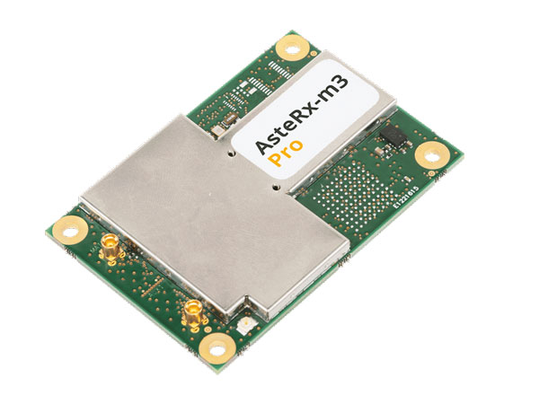
The AsteRx-m3 Pro is an ultra-low power GNSS rover receiver. It is compact and high-performance, making it suitable for integration into high-precision industrial applications. It incorporates multi-frequency, multi-constellation GNSS technology as well as anti-jamming algorithms for availability and reliability. The AsteRx-m3 Pro features AIM+ advanced anti-jamming and anti-spoofing technology as a part of Septentrio’s GNSS+ Technology Suite.
This receiver is designed for rover (mobile) applications, making it an easy-to-integrate solution for any kinematic application where reliable high-accuracy positioning is needed. It is available in single or dual antenna mode, for high quality heading and pitch, or heading and roll information.
GNSS heading is available directly from initialization and removes reliance on vehicle dynamics or magnetic sensors. This is an optional feature.
“Septentrio OEM receivers come in a variety of form factors, from compact modules to credit-card boards,” Danilo Sabbatini, OEM product manager at Septentrio, stated. “Our multi-frequency OEM receiver portfolio includes products that fit various user needs from purely rover GNSS high accuracy positioning to heading receivers, as well as GNSS/INS boards for inertial navigation or mapping.”
Image: Septentrio
Aside from surveying and mapping, the AsteRx-m3 Pro is suitable for assured position, navigation and timing (PNT), autonomous vehicles, precision agriculture, logistics and port operations, mining and construction, rail, robotics, space and UAV applications.
Plowing the Way
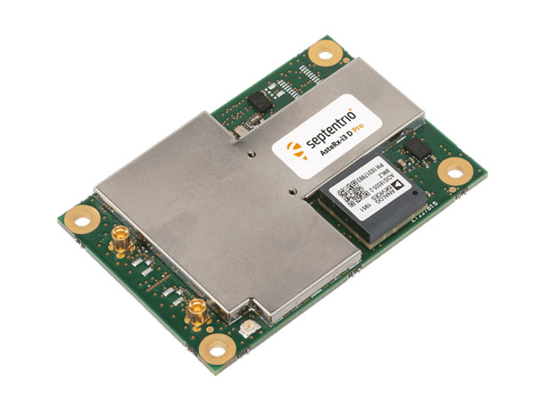
The increase in demand for food due to population growth challenges farmers to increase production. To help them do this, Septentrio is working with manufacturers of agricultural machinery to enable them to achieve centimeter-level positioning accuracy.
Image: Septentrio
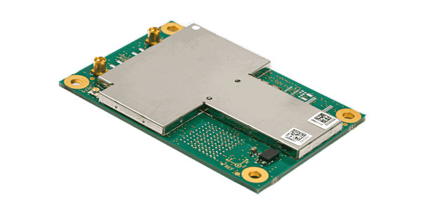
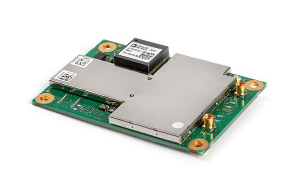
The AsteRx-i3 D Pro is a ready-to-use GNSS/INS single-board receiver that delivers reliable centimeter-level positioning combined with 3D orientation (heading, pitch and roll) in demanding environments. Its inertial sensor provides orientation and positional dead-reckoning, making it suitable for systems that require continuous positioning even during short GNSS outages. It provides reliable and accurate positioning by enhancing GNSS with an inertial measurement unit (IMU).
Image: Septentrio
The AsteRx-i3 D Pro is quad-constellation and multi-frequency. It provides all-in-view real-time kinematic positioning and features AIM+ unique interference monitoring and mitigation system and other advanced GNSS+ algorithms.
Like the AsteRx-m3 Pro, the AsteRx-i3 D Pro is also suitable for assured PNT, autonomous vehicles, logistics and port operations, mining and construction, rail, robotics, space, survey and mapping, and UAV applications.
For more information about Septentrio’s OEM boards, click here.
Flying High
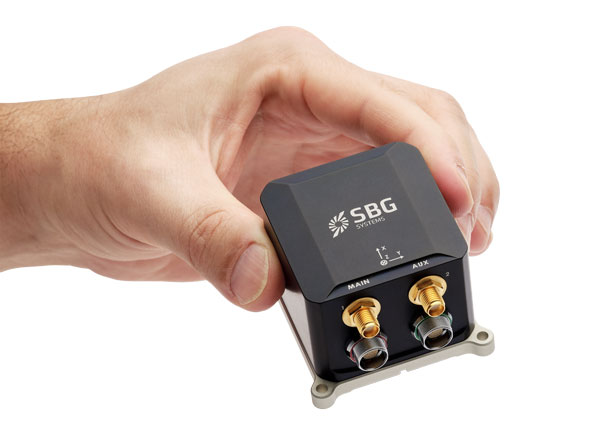
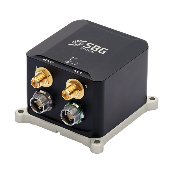
SBG Systems has released Ekinox Micro, a compact and rugged high-performance inertial navigation solution designed to deliver accuracy in challenging environments. Ekinox Micro combines a high-performance MEMS tactical inertial sensor with a quad-constellation, dual-antenna GNSS receiver, making it suitable for mission-critical applications.
Image: SBG Systems
GPS World caught up with Yoann Plénet, head of products at SBG Systems, at AUSVI XPONENTIAL in May. He elaborated on Ekinox Micro’s key markets and features.
“This is Quanta Micro in a box with the same performance and the same benefits that you get [with the Quanta Micro]: inertia, enhanced GNSS, and complement[ing] the GNSS,” Yoann said. “At the same time, we are targeting very rough environments, especially larger drones which are most likely military ones. So, [Ekinox Micro] is a very rugged product.”
Ekinox Micro includes pre-configured motion profiles for land, air and marine applications, enabling the sensor and algorithms to be tuned for maximum performance in any condition. The device is designed for ease of use and integration, with simple connectors, a web configuration interface, a datalogger, Ethernet connectivity, a PTP server, a REST API for configuration, and multiple input and output formats.
Image: SBG Systems
Ekinox Micro is compatible with real-time kinematic (RTK) and based on a tactical 0.8°/h class inertial measurement unit calibrated across the entire operating temperature range. It features accuracy roll/pitch of 0.015°, accuracy heading of 0.035°, and accuracy position of 1.2 m without any corrections or 1 cm in RTK.
Yoann also said that with the rise of jamming and spoofing, Ekinox Micro is designed with enhanced technology to mitigate those threats.
“Jamming and spoofing is ongoing and is an issue for more and more of our clients. So, we have worked a lot — and that is something that is beneficial to all of our product ranges — on enhancing our algorithms and our technology so we can better detect jamming and spoofing than we could before,” Yoann said.
Ekinox Micro will be commercially available in September. Click here for more information on Ekinox Micro.
Bonus Device
Image: Septentrio
The Septentrio mosaic-X5 is a multi-band, multi-constellation GNSS receiver in a low power surface mount module with a wide array of interfaces. It is designed for mass market applications such as robotics and autonomous systems — capable of tracking all GNSS constellations, supporting current and future signals.
The mosaic-X5 has an update rate of 100 Hz, is easy to integrate, and is optimized for automated assembly.
Antoon De Proft, Septentrio’s CEO, mentioned in the April 2023 issue of GPS World the company’s innovation in Leuven, Belgium.
“Septentrio’s 20 years of experience in GNSS technology as well as our strategic partnership with the European Space Agency and close collaboration with the IMEC semiconductor technology hub has enabled us to produce the mosaic-X5 receiver,” he said. “This compact module is one of the highest performing and resilient GNSS receivers on the market. It is used in a wide array of applications, especially where the position is mission critical. Examples include a wide variety of autonomous devices, including drones that benefit from mosaic’s lightweight and low-power design.”
Francois Freulon, head of product management, added, “Reliability and resilience to GNSS vulnerabilities is a key pillar on which we base our receiver design. RF interference in the form of jamming and spoofing* is increasingly common, which is why we are investing heavily in securing our receivers at the core with the latest hardware and software techniques. In addition to the AIM+ patented technology, the mosaic module already includes OSNMA functionality, which will offer end-to-end authentication on Galileo’s civilian signals, protecting receivers from GNSS spoofing attacks.”
For more information about Septentrio’s mosaic GPS/GNSS modules, click here.
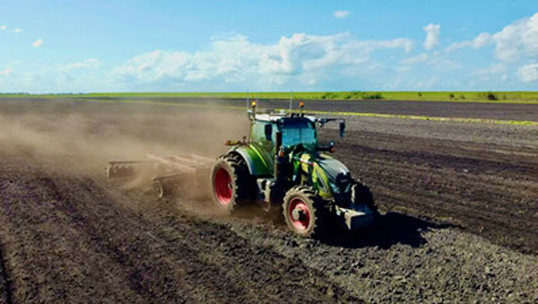
Precision agriculture (PA) — which uses electronic information to better manage spatial and temporal variability in crops, livestock, forestry and other biological systems — is profitable, as proven by the rapid and widespread adoption of GNSS guidance for mechanized agriculture. Other enablers of PA include variable rate technology (VRT), remote-sensing using satellites and unmanned aerial vehicles, geographic information systems (GIS) and soil sampling.
In my introduction to our January cover story, I requested pointers to any “independent, reliable and comprehensive study” as to PA’s return on investment. In response, Professor Won Suk Lee, of the Department of Agricultural and Biological Engineering of the University of Florida Gainesville, introduced me to Professor James Lowenberg-DeBoer, who has more than 30 years of worldwide experience in agricultural research, teaching, outreach and leadership and was the president of the International Society of Precision Agriculture. His research focuses on the economics of agricultural technology.
Dr. Lowenberg-DeBoer wrote to me that “thousands of studies of profitability of precision agriculture” using “a wide range of methods and assumptions” arrive at “a relatively consistent set of conclusions.” He detailed them in a chapter on the economics of PA he wrote for a book published in 2019 (Precision agriculture for sustainability, edited by Dr. John Stafford, Silsoe Solutions, UK and published by Burleigh Dodds Science Publishing) and pointed out to me that additional studies of the topic conducted since then have not altered its conclusions.
Lowenberg-DeBoer used adoption of PA as a proxy for its profitability, because, he wrote, “Farming is a business and technology is adopted if it provides benefits for the farmer and farm household.” He focused on PA for crops on relatively large-scale mechanized farms, but the same principles and general conclusions apply to livestock, forestry and other biological production systems and to medium and small farms.
“Since GNSS guidance was introduced for ground-based agricultural equipment in the late 1990s,” he wrote, “almost all economic studies have shown positive economic benefits which could be quantified and substantial qualitative benefits which were more difficult to measure.”
He reported that within about 10 years of the introduction of both lightbars and autosteer, GNSS was used by about 80% of the dealers. Adoption of PA sensors, on the other hand, was slower. “While GNSS guidance is being adopted quickly almost wherever agriculture is mechanized, VRT is more likely to be found in ‘hot spots’ where the profit potential and soil variability combine to motivate adoption.”
Advances in autonomous robots will further revolutionize agriculture, Lowenberg-DeBoer predicted. “Implementing cropping tasks with swarms of small robots will change agronomic practices and the geography of agriculture. For example, with robotic pesticide application, it might be possible to spray each pest individually instead of broadcast application. This could reduce the amount of pesticide applied by [more than] 90% and reduce the negative effects on beneficial species.”
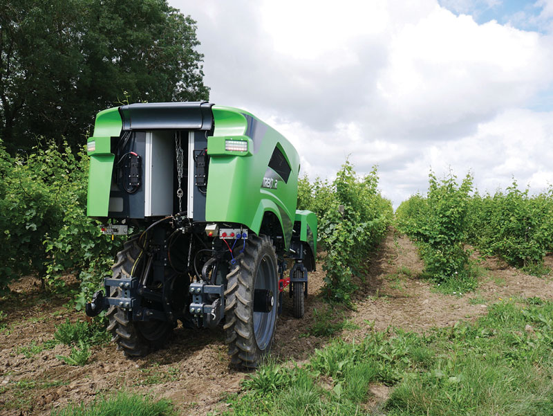
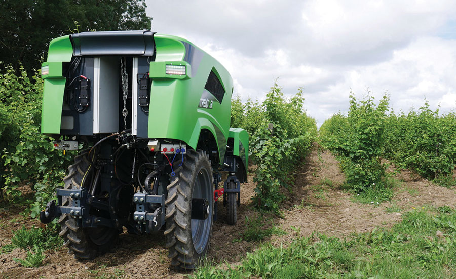
The Trektor hybrid robot for agriculture, made by the French company SITIA, can work on a variety of crops by changing the width of its wheelbase and can perform many repetitive tasks, such as spraying and hoeing. (Image: SITIA)
Precision agriculture has been around for more than 30 years and now covers the majority of U.S. farmland. It refers to the ability of farmers to observe, measure and respond precisely to the variability of soil and crop characteristics within and between fields by using maps of these characteristics and GNSS navigation. It enables them to reduce inputs of seed, water, fertilizer, pesticides and fuel while increasing outputs. It also enables them to work at night and in the fog and automate many functions at large feed lots.
For precision agriculture, GNSS integrity can mean the difference between, say, a robot protecting a vineyard by weeding and spraying pesticides or damaging it by straying onto the vines.
Autonomous Tractors, Mowers, and Feed Monitors
SITIA, a French company, has developed an autonomous tractor that is used by, among others, an organic vineyard in France’s Loire valley to tirelessly weed the narrow rows between the grape vines — compensating for the movement of young workers to cities. Thanks to the high accuracy and integrity of the Septentrio GNSS heading receiver inside, the autonomous tractor has decreased the damage to the vineyards by more than an order of magnitude compared to the traditional work done by a farmer with a manual tractor.
Renu Robotics, based in San Antonio, Texas, makes a robot for vegetation management, called Renubot. It uses machine learning, a form of artificial intelligence, to plan its route, optimize its energy consumption, perform self-diagnostics, collect environmental data and assess the topography that it traverses.
Navigation is based on a stored map of paths, a Septentrio RTK GPS receiver and sensors to avoid obstacles. A radio link enables the Renubot to communicate with a control center, for reporting and updates. When the Renubot returns to its recharge pod, it charges its lithium battery and performs updates and downloads.
Manabotix Pty. Ltd., an Australian company, has developed an automated system to monitor cattle in large feedlots, using GNSS, lidar scanning and other vision or perception technologies and artificial intelligence. This has greatly improved the accuracy and consistency of feedlot volume estimates, which for the previous 150 years had been the responsibility of a select few employees, who would visually gauge the amount of feed in concrete troughs. This visual inspection by humans was inherently imprecise, subjective, and inconsistent, often causing animals to eat too much or too little one day and get off their optimal growth curve or even become ill. Manabotix’s solution consists of a Septentrio AsteRx-U GNSS receiver and antenna, a lidar scanner, and an onboard processing platform.
Statistical Analysis
Integrity is a key aspect of all these applications. A part of delivering integrity is a statistical analysis called receiver autonomous integrity monitoring (RAIM), which was developed for such safety-critical applications as aviation or marine navigation. A refinement of RAIM, called RAIM+, takes this analysis to the next level as part of a larger positioning protection package.
For autonomous operation, it can be particularly hazardous to be overly optimistic about GNSS accuracy. This parameter is reported in the form of positioning uncertainty, which is the maximum possible error on the calculated position. It is especially necessary in challenging GNSS environments, where the receiver has a direct line of sight to only a limited number of GNSS satellites or where GNSS signals are degraded. RAIM alerts users when their receiver’s uncertainty strays beyond the limits they have chosen for their application.
Users can be deceived by a consistent position or movement — which can be consistently inaccurate. The positioning uncertainty gives them an indication of the extent to which they can rely on their receiver’s positioning accuracy at any given moment. The receiver operator can set an alarm limit, so that the receiver can flag situations when positioning uncertainty becomes too large.
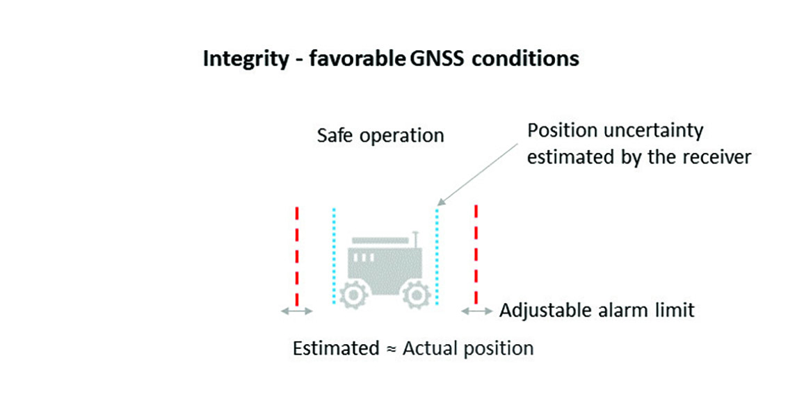
The blue line in Figure 1 shows position uncertainty estimated by a GNSS receiver under favorable conditions, when the view of the sky is unobstructed, and the receiver has a direct line-of-sight to many satellites.
Figure 1. Under good GNSS conditions, the position uncertainty shown by the blue lines is well within the alarm limits, indicating safe operation. The actual position of the receiver should always remain within the blue uncertainty boundaries. (Image: Septentrio)
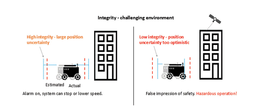
During favorable conditions, the positioning uncertainty stays well below the alarm limit because the calculated position is almost the same as the robot’s actual position. However, in challenging environments, the truthfulness of positioning uncertainty becomes most critical (see Figure 2).
Figure 2. In challenging environments receivers with high integrity report large positioning uncertainty, flagging possible inaccuracies to the system. If the receiver is too optimistic about its accuracy, the operation becomes hazardous. (Image: Septentrio)
For instance, when the view of the sky is partially obstructed by buildings or foliage, the receiver has access to only a limited number of GNSS satellites, making it harder to calculate accurate position. In such cases the receiver must report a higher positioning uncertainty, so that the system can take adequate action such as switching to lower speeds, staying further away from predefined boundaries, or stopping.
A low integrity receiver may keep reporting an optimistic positioning uncertainty, that stays below the preset alarm limit even when the calculated position is way off from the actual position. The number may look fine, but effectively it becomes a “robot on the loose,” no longer on its planned path with a risk of damaging itself and its surroundings.
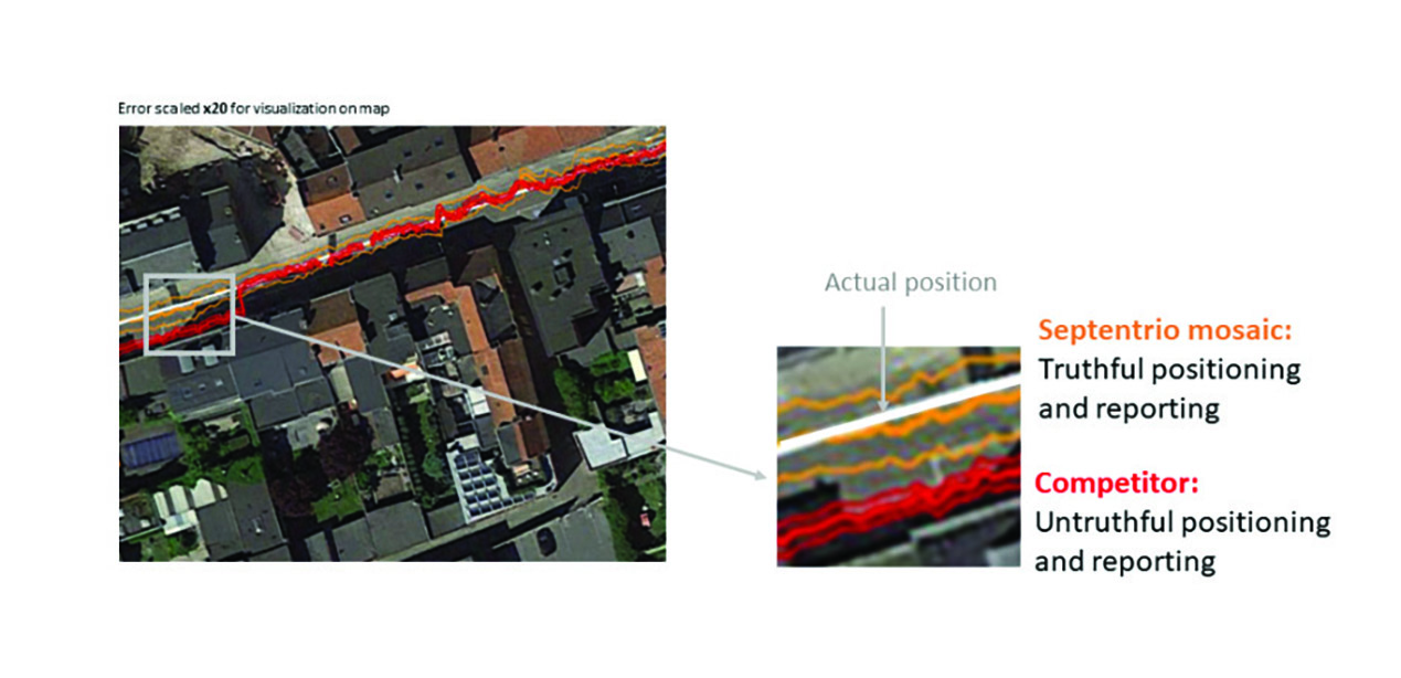
Let us look at uncertainty limits in action during a GNSS car test in an urban canyon, where the view of the sky is partially obstructed by houses (see Figure 3). The orange lines are the positioning and its uncertainty boundaries reported by a Septentrio mosaic GNSS module in the car, while the red lines are the positioning and its uncertainty boundaries reported by another popular GNSS receiver. The white line shows the actual position of the car as it drives along the road. The orange uncertainty boundaries of the mosaic receiver are truthful and somewhat wider in this challenging environment, and you can see that the actual position always remains within these boundaries. On the other hand, the red trajectory jumps off course in a certain challenging spot on the road, with the actual position no more within the uncertainty boundaries, which remain too optimistic. In this case the competitor’s receiver gives a false sense of security and the system is unaware of its hazardous operation.
Figure 3. In an urban canyon car test the Septentrio receiver reports truthful position uncertainty. A competitor receiver seems to be more accurate, while the actual position is not even within its reported uncertainty boundaries. (Image: Septentrio)
If the receiver depicted by the red line provided navigational information for an ADAS automotive system, for example, this could mislead the system into thinking that the car switched lanes. If the system then attempted to correct the trajectory by switching back to the “correct lane” this would result in taking the car off course and potentially hitting the sidewalk or even another car.
RAIM vs RAIM+
The underlying mechanism behind truthful positioning uncertainty reporting is RAIM, which ensures a truthful positioning calculation based on statistical analysis and exclusion of any outlier satellites or signals. Septentrio receivers are designed for high integrity and take RAIM to the next level with RAIM+, guaranteeing truthfulness of positioning with a high degree of confidence.
In Septentrio receivers RAIM+ is a component of a larger receiver protection suite called GNSS+ comprising positioning protection on various levels including AIM+ anti-jamming and anti-spoofing, IONO+ resilience to ionospheric scintillations, and APME+ multipath mitigation.
Septentrio has fine-tuned its RAIM+ statistical model with more than 50 terabytes of field data collected over 20 years. It removes satellites and signals which may give errors due to multipath reflection, solar ionospheric activity, jamming and spoofing, while working together with the GNSS+ components mentioned above. Because of this multi-component protection architecture, it achieves a very high level of positioning accuracy and reliability which goes well beyond the standard RAIM. The RAIM+ statistical model is adaptive, highly detailed, and complete, taking advantage of all available GNSS constellations and signals. The full RAIM+ functionality is also available in Septentrio’s GNSS/INS receiver line. User controlled parameters allow it to be tuned to specific requirements.
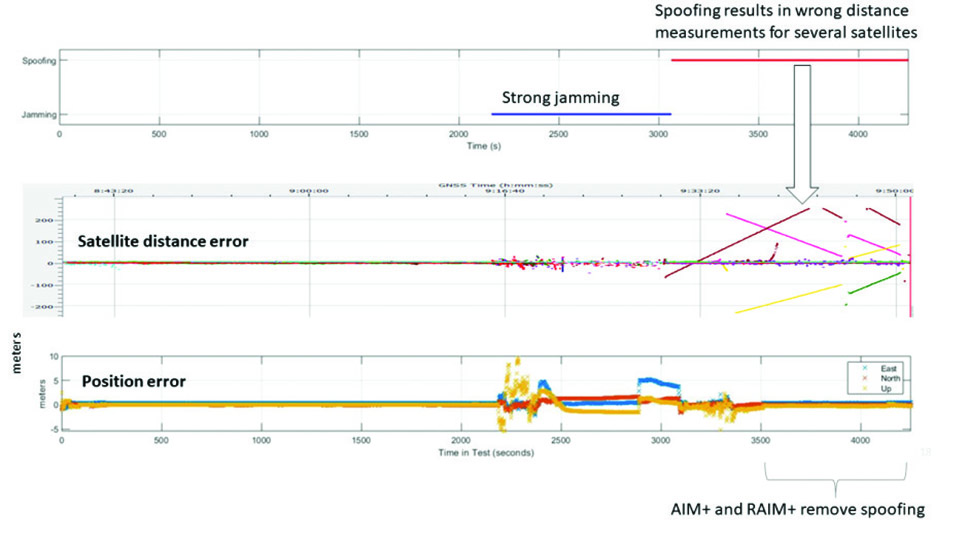
The diagram in Figure 4 shows RAIM+ in action during a jamming and spoofing attack on a Septentrio GNSS receiver. While AIM+ removes the effects of GNSS jamming, both AIM+ and RAIM+ work together to block the spoofing attack. Satellites with high distance errors, shown on the middle graph, are removed by RAIM+ since they do not conform to the expected satellite distance.
Figure 4. In this scenario jamming gives satellite distance errors but is countered by AIM+ technology. During spoofing AIM+ eliminates some of the spoofed satellites, while other satellites that have wrong distances are dismissed by RAIM+ algorithms. (Image: Septentrio)
This example shows that even in the case of jamming and spoofing, Septentrio’s high integrity receiver technology delivers truthful and reliable positioning on which any autonomous system can count.
GNSS Design Around Reliability
GNSS receivers designed to be reliable strive for high integrity in both reporting of the positioning uncertainty as well as in RAIM+ advanced statistical modelling. This ensures that these receivers provide truthful and timely warning messages and are resilient in various challenging environments. Other technologies such as inertial navigation system (INS) can also be coupled to the GNSS receiver to extend positioning availability even during short GNSS outages. Quality indicators for satellite signals, CPU status, base-station quality and overall quality allow monitoring of positioning reliability at any given time. High-integrity GNSS receivers provide truthful positioning in autonomous machines such as the SITIA weeding tractor. They are also crucial components in safety-critical applications, assured PNT and any other application where accuracy and reliability matters.