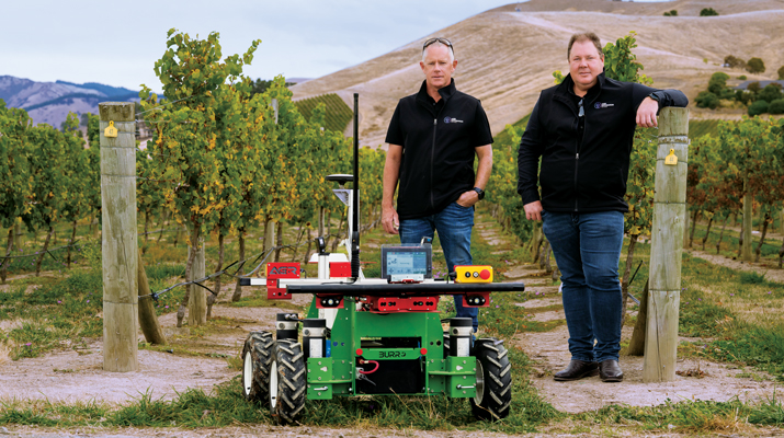
Unicore has introduced the UM981 series, a high-precision positioning module that integrates RTK and inertial navigation system (INS) technologies. The solution leverages GNSS and INS navigation to cater to applications in precision agriculture, surveying and mapping.
The module is compatible with all major navigation systems and frequencies, tracking signals from multiple systems simultaneously for enhanced performance even in challenging environments. Additionally, the UM981 series supports open Precise Point Positioning (PPP) services such as BDS-3 PPP-B2b, Galileo E6 HAS and QZSS L6 MADOCA-PPP, achieving 10 cm positioning accuracy with a convergence time of under 10 minutes, according to Unicore.
The UM981 series processes high-frequency GNSS and IMU data streams efficiently, offering RTCM data transmission at up to 20 Hz, single-point positioning and RTK at up to 50 Hz and integrated navigation data and IMU raw data at up to 100 Hz. These capabilities make it suitable for dynamic scenarios requiring high precision.
In precision agriculture, the UM981 module simplifies machinery auto-steering systems by enabling single-antenna positioning and attitude determination through advanced MEMS technology. At speeds above 1 km/h, it achieves heading accuracy better than 0.3° and roll/pitch measurements better than 0.2°, with accuracy improving as speed increases. The module supports CAN Bus communication and can be customized to work with the ISOBUS Protocol, eliminating the need for switching between interfaces during serial port communication.
For surveying and mapping applications, the UM981S variant delivers high-accuracy positioning and tilt measurement using GNSS and INS fusion algorithms. It eliminates traditional shake-to-start requirements with a walk-and-go feature that allows users to initialize tilt measurement simply by walking with the measurement pole. The module provides 2.5 cm accuracy within a 30° tilt range and supports measurements at larger angles up to 120°, making it suitable for complex environments such as building corners or areas under tree canopies.
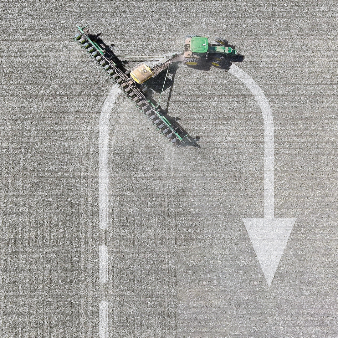
An early 1900s Italian folk song tells of a farmer walking into his fields at dawn to spread wheat seeds with his hand from a small bag.1 Farming has changed quite a bit since then. After remaining essentially unchanged for about 12 millennia, in the past century, it has been transformed by such innovations as tractors, electrification, chemical fertilizers and pesticides. In the 1990s, precision agriculture (PA) emerged. (This magazine produced a few supplements on the subject around 1999. If you still have any of them, please let me know.)
PA reduces inputs of water, fertilizer, seeds, pesticides and fuel and increases harvests by mapping variations in soil characteristics and plant health and then using those maps to adjust the inputs using variable rate technology on sprayers. It also ensures that no part of a field is sprayed twice or missed and greatly reduces overlap in seeding and tilling. Double spraying is costly and wasteful; missing a row when spraying pesticide can cause pests to concentrate there and then spread, nullifying a whole spraying operation.
The data for the maps are gathered from sensors on tractors and other farm machinery in the fields, as well as by aerial platforms — nowadays, mostly UAVs. GNSS receivers are essential in guiding the farm machinery. The required accuracy depends on the crop but is typically at the centimeter to decimeter level.
Increasingly, farm machinery also incorporates a variety of other sensors, both to compensate for GNSS outages and to minimize the risk of collisions, such as when a cow crosses the path of a tractor. To maintain navigation during GNSS outages, inertial navigation is used. For obstacle avoidance lidar, radar and stereo vision cameras are used to measure the distance to the object. (Both challenges — navigation in GNSS-denied areas and obstacle avoidance — and their solutions are very similar to those encountered with autonomous vehicles on roads.)
In-cab displays enable growers to monitor their progress in real time. They often also download the data and maps to a laptop to better identify missed spots or areas with special issues and to plan their next task.
Manufacturers of PA equipment compete in a global market. Some challenges are the same everywhere, while some are specific — such as strong ionospheric scintillations in Brazil or antiquated agricultural practices in Japan’s Furano region. For this year’s cover story on PA, I discussed these challenges and the latest generation of farming hardware, software and services with
■Kirstin Schauble, director of systems engineering, ANELLO Photonics
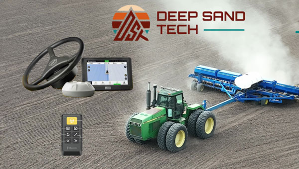
■ Joey Koebelen, founder and CEO, Deep Sand Technology
■ Chad Huedepohl, PA portfolio manager, autonomy and positioning division, Hexagon
■ Ken MacLeod, director of product management and Gordon Echlin, director of business development, Calian GNSS.
This article contains a few excerpts from those interviews. I also received case studies from AgLeader Technology, ComNav Technology and Harxon Corporation.
ANELLO Photonics makes silicon photonics optical gyroscopes, which enable accurate dead reckoning without GNSS and are targeted mostly at the autonomy market. (Anello means ring in Italian, which reflects the nature of the company’s technology and the Italian-American background of its CEO, Mario Paniccia.) Because ANELLO specializes in high precision in situations with obstructed GNSS signals, orchard cultivation is one of the agricultural practices in which it specializes. “Orchards have high-value crops, such as almonds or walnuts, and you’re driving your tractor between very narrow rows with trees completely covering the sky above you,” Schauble said. “Our job is to replace that GNSS input with our inertial navigation system (INS) input.”
Deep Sand Technology — in partnership with GEODNET, the largest real-time kinematic (RTK) network in the world — sells affordable RTK corrections to farmers. It also maintains and troubleshoots the system, compensated by the network’s cryptocurrency. “We handle the blockchain and use it for maintenance,” said Koebelen. “We have someone that checks every day and makes sure that the bases are up. We do the support on it. Instead of charging for that, we take the tokens; that’s just our part of the program, and they get free RTK.” Koebelen, who is also a peanut farmer, adds: “You can trust anything that we sell because it has been tested and used by a farmer and is supported by a farmer.”
Hexagon, a very large company, makes a wide range of sensors that capture and display data about physical reality. Its latest contributions to PA include the TerraStar-C PRO and the TerraStar-X Corn Belt corrections services, which incorporate improvements in ionospheric resiliency. “Especially in the Brazil market, some growers were often experiencing hours of downtime due to ionospheric scintillation,” said Huedepohl. “With the ionospheric enhancements that we’ve added, that downtime now is down to just a few minutes here and there.” He also cites safety enhancements for the autonomy market, such as dual antenna solutions and geofencing.
Calian GNSS is a global supplier of technical solutions, services and products to the space communications, defense, wired and terrestrial wireless, manufacturing, GNSS, agricultural technology and nuclear industries. The company’s recent entries in the PA market include GNSS antennas with lower elevation gain and extended filtering. “Our GNSS agriculture antennas support centimeter level precision, have best in class lower elevation angle gain enabling L-Band correction reception (at northern and southern latitudes), and have eXtended Filtering (XF), which creates very deep attenuation of nearby out of band radio frequency signals,” said Echlin. “Having a digital signal from the antenna to the smart ag controller simplifies and reduces the cost of the installation,” said MacLeod.
Ag Leader, founded in 1992 and focused exclusively on precision farming technology, offers a complete line of systems that integrate with existing farm machinery. In February, it introduced the RightPath passive implement steering solution to alleviate the problem of trailed implements drifting off the guidance line by up to 10 inches or more, even when farmers utilize auto steer and on flat ground. RightPath keeps implements centered on the guidance line, ensuring precise input placement and increasing operational efficiency throughout the growing season while minimizing crop damage, yield loss and operator challenges, Ag Leader said. To utilize RightPath, both the vehicle and the implement require Ag Leader’s GPS 7500, but only the vehicle needs to be equipped with TerraStar-C, TerraStar-X, or RTK. RightPath will be available in late fall 2025 through a single purchase unlock and without any recurring subscription fee.
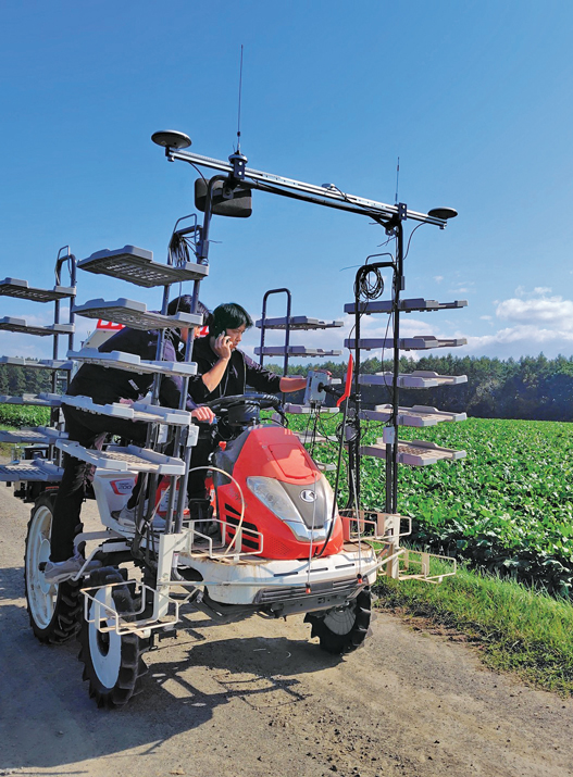
ComNav Technology is an original equipment manufacturer (OEM) that develops and manufactures GNSS OEM boards, receivers and solutions for high-precision positioning applications worldwide. Japan’s Furano region is renowned for its vast farmland and abundant agricultural resources. Still, it is challenged by traditional manual driving methods that provide insufficient accuracy, low efficiency, and operator fatigue during prolonged tasks. To address these issues, ComNav introduced the AG502 autosteer system, which integrates satellite reception, positioning, navigation and autonomous driving. It is compatible with a variety of mainstream tractors on the market and is suitable for a wide range of agricultural tasks such as ridging, seeding, spraying and harvesting, ComNav said. In the Furano project, the AG502 demonstrated its versatility through its successful deployment on a transplanting machine.
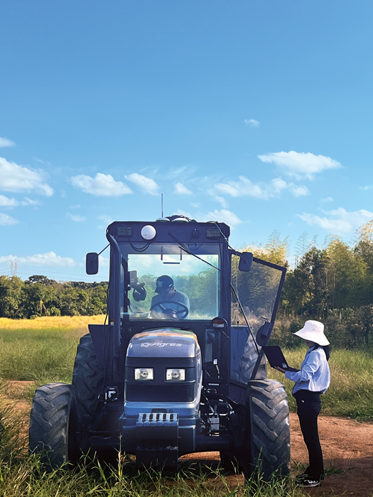
Harxon Corporation makes GNSS positioning antenna solutions. The company has been collaborating with Brazilian agricultural navigation solutions and systems developer Agres to integrate Harxon’s Smart Antenna into the AgresAutopilot System. This secure and robust agricultural navigation solution has been widely adopted by Brazilian agribusinesses to provide automatic steering on straight or curved parallel lines to assist with such field operations as preparing the soil, planting seeds, cultivating the plantation and harvesting the crops. These systems are suitable for various brands and tractor/vehicle models such as Kuhn, John Deere, Valtra, Massey Ferguson, New Holland, LS, Landini, Jacto and others.
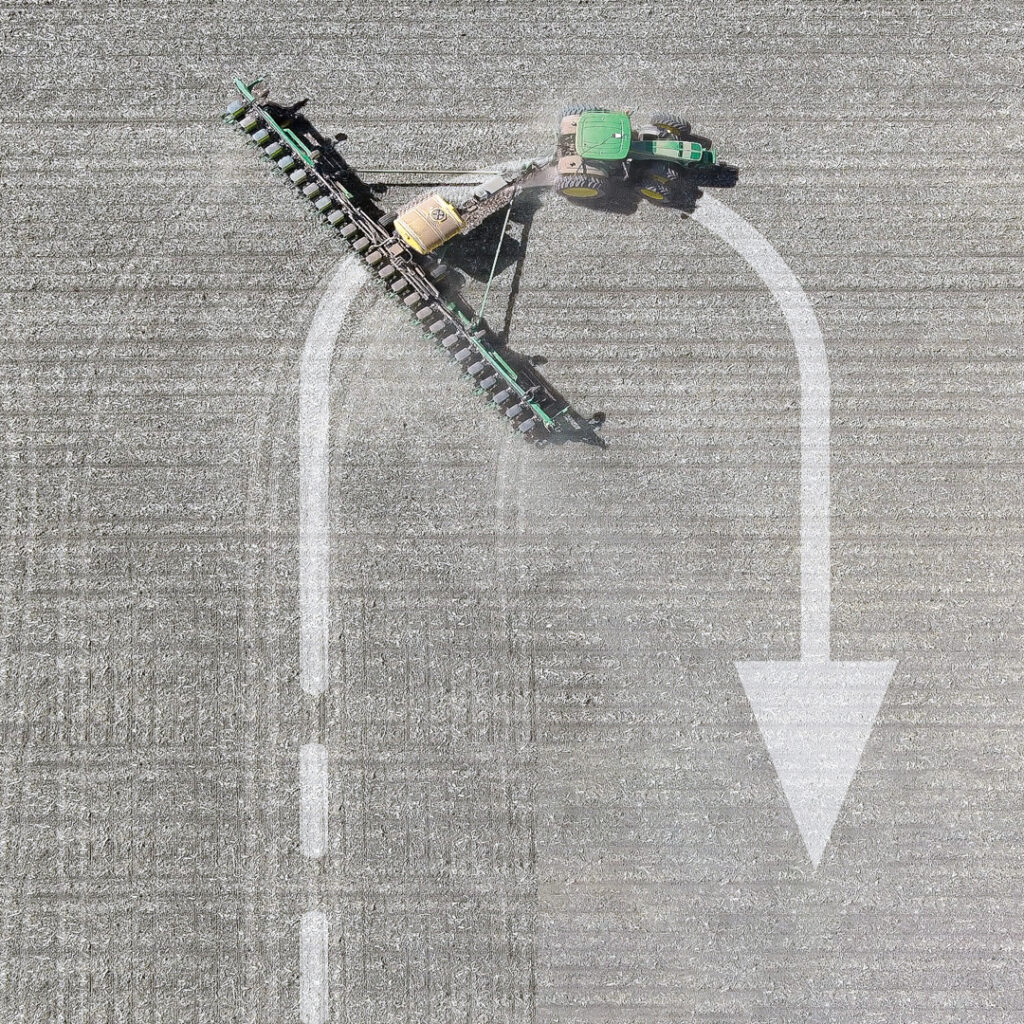
To maximize an operator’s turning accuracy and efficiency, Ag Leader introduced TurnPath, hands-free steering for automatic, repeatable end-of-row turns. (Photo: Ag Leader)
Challenges
The key technical challenges faced by PA systems include minimizing multipath and RF interference and monitoring the positions of implements relative to the tractor. “Agriculture requires positional accuracy, so mounting an antenna on a farm machine is not a trivial matter,” said MacLeod. “On metallic machinery, radio frequency surface currents and reflections (multipath) will degrade the antenna radiation pattern, and RF noise coming from other electronics on the machine can interfere with GNSS.” Additionally, because most GNSS applications now are full band, “the challenge is designing antennas that are small and full band, and which also reduce local multipath on the machine.”
Regarding the position of the implements, MacLeod said: “Many agricultural applications use the moving base technique to estimate a precise heading which can be used to monitor pass to pass overlap. Calian GNSS have smart antennas that support the moving base application.”
Accuracy and Reliability
Nearly all PA practices require RTK, which gives repeatable accuracy of 1 cm to 2 cm. “I have this conversation daily with farmers,” Koebelen said. “All crops or farm practices benefit from RTK, even if you’re just doing hay work — whether you’re planting or harvesting. We can’t control the weather, commodity prices, or fuel prices but we can reduce input costs. So even if you’re just tilling, GEODNET RTK will pay for itself and is better than using traditional autosteer, because you’re eliminating all overlap.”
Additionally, farmers need reliable repeatability, even from one season to the next, to be able to return to the same spot to harvest what they planted. “Peanut farmers may plant with RTX or SF3, but satellite-based corrections, even higher precision ones, didn’t provide them enough repeatability to come back to harvest,” said Koebelen. “So, they still had to adjust their lines or hand-drive them. If the spacing between passes are off by even two to three inches, you’re going to lose peanuts. That’s why peanut farmers — as well as growers of potatoes, cucumbers, and other crops — need RTK.”
Once they enter a GNSS-denied area, such as an orchard, farm machines will need a dead reckoning capability that can keep them within a 20 cm to 30 cm error, said Schauble. “This is typically posed as a cross-track error. Errors in the direction of the distance traveled are slightly less important, because you can tell based on visuals when you exit a row.”
Growers think of reliability, accuracy and repeatability in terms of whether they can count on a system to do what they are asking it to do, Huedepohl explained. “They think about all those things. They do not necessarily focus on one thing versus another.”
Retrofitting
While many agricultural systems are proprietary, there is also a lot of mixing-and-matching and retrofitting going on. More than 90% of new tractors come with factory-installed guidance, but some growers want to retrofit new receivers on their machines, either because they did not have them or to upgrade. On some machines, it is possible to feed better positioning data — for example, integrating GNSS and inertial navigation — into the port that previously took in only GNSS data, using a standard NMEA format.
“It’s a simple plug-and-play to exchange someone’s GNSS receiver with our INS solution. Obviously, they need to do some testing to optimize placement, installation and stuff like that,” said Schauble. “Many companies are retrofitting existing tractors with an autonomy stack. They take commercial off-the-shelf (COTS) systems, such as ours, or a lidar or a camera, and retrofit a tractor. That’s their business model.”
The AG502 autosteer system being tested and calibrated on a transplanter in Japan’s Furano region, which is renowned for its vast farmland. (Photo: ComNav Technology)
Additional Sensors
Among the additional sensors often used are wheel odometers. “Without the wheel speed, you’re relying heavily on accelerometers,” said Schauble. “Growers cannot afford to pay $100,000 for a reference-grade system. The navigation systems for these applications use MEMS accelerometers, as we do. So, wheel speed aiding is extremely important to maintain that distance traveled.”
Integrating GNSS and inertial measurement units (IMUs) has long been standard. Increasingly, this integration is done inside an antenna, called a smart antenna. Calian, among others, does that. “We also have smart antennas that employ the L1-L5 observation pair rather than L1-L2, since the L5 signal is stronger and performs better under cover,” said MacLeod. “L5 uses an enhanced signal architecture with 10x faster chipping rate (10.23 MHz) offering more precise standard localization and improved multipath mitigation for reflections exceeding 29.3 m.”
Corrections
Corrections have also been key to the evolution of PA. A reference base station can provide 1-inch accuracy for up to 21 miles, degrading beyond that distance. It needs a WiFi network to communicate, so farmers often place the base station near their home and connect it to their home network. “We haven’t found an internet connection that isn’t quick enough to handle that,” said Koebelen. “From there, you can use your hotspot with a SIM card on your phone, and it’s like texting, so it will not drop like with voice calls. We haven’t run across rural areas where cell coverage is the limiting factor.”
RTK adoption is growing among farmers. “In the past, many people did not want to use RTK, because it was not very affordable nor easy,” Koebelen said. “However, now that we have these networks [such as GEODNET], you’re going to see a lot more people rely on the precision of RTK and you’re going to see many new products come out. Right now, even John Deere, Trimble and other major brands that are more expensive are trying to make the tier below RTK more affordable or easier to get — for example, RTX, SF3, the satellite-based corrections.” GEODNET’s network is growing rapidly, he said, “because our price for RTK is lower than Trimble’s or John Deere’s basic entries, which use free satellite signals that drift throughout the day.”
Huedepohl agrees that RTK has improved while prices have dropped significantly. “Earlier in my career,” he said, “RTK positioning was very expensive and satellite-based augmentation systems (SBAS) were not as stable. Also, RTK systems and such used a single constellation for the longest time. We started adding in GLONASS and then positioning network (Ntrip) corrections, which gave us a lot more robustness.”
Precise point positioning (PPP) has also improved. It used to have convergence times of up to 45 minutes. “Then, you would drive underneath one tree on the edge of a field, and you had to start all over,” Huedepohl recalls. “That did not sit well with farmers, so PPP corrections struggled to take off. Because of those early experiences, it took a long time for the market to start to accept the newer PPP models that we’ve seen in the past seven or eight years. Now there are farmers who enjoy the reliability of those PPP corrections.” The convergence time for one of Hexagon’s PPP services, TerraStar-C PRO, is often less than five minutes, according to Huedepohl. “We have a fast startup time. So, if the tractor was shut down, already converged and you turn it back on, most people are going to be reconverged in just a minute or two.”
Harxon enables autonomous agricultural applications with GNSS antennas, smart antennas and wireless data radios. (Photo: Harxon)
Division of Labor
The division of labor between manufacturers of PA equipment depends, in part, on whether a system is a retrofit or built from scratch. “If you are, let’s say, John Deere, and you own the entire autonomy stack within this tractor, then you can take our INS solution, add cameras, maybe add a lidar, and you can have your own fusion of those sensors,” said Schauble. “We have our own sensor fusion with IMUs and GPS. The tractor’s autonomy stack can do the sensor fusion with our output and other visual sensors, such as cameras and lidars.”
“Dealerships want their tractors to be known as having the highest tech,” said Schauble. “For a dealership to offer our state of the art, autonomy-enabling technology would be a huge benefit to them.”
Another differentiator is whether a factory-installed system is an OEM or branded. “We’ve been providing NovAtel branded receivers to AGCO for many years, through their channel, both factory-installed and aftermarket. Some of the others, such as CNH, are white labeled, so it would just say ‘Case-IH’ or ‘New Holland’ and have no Hexagon markings.”
Whether OEM or aftermarket, most manufacturers have some type of proprietary integration. “There are products that are just NEMA; they are typically at the lower end and priced much lower,” said Huedepohl. “The higher performing flagship products out of everybody’s portfolio are usually doing a more customized integration.”
Echlin has a similar perspective: “We provide products to OEMs who designed our products into their machinery. There are also system integrators and aftermarket system providers that use our smart antennas.”
According to Harxon, one reason for the success of its smart antenna in the agriculture market, especially for autonomy users, has been its ease of integration and high performance. “GNSS positioning is just one part of an autonomous system, and the autonomous integrators don’t necessarily have resources or expertise to develop an OEM component portfolio. Therefore, it’s a timesaving and cost-effective choice to directly integrate a smart antenna into an autonomous system.”
1 “Di buon mattino il contadino va nei suoi campi a seminare il grano. Ha un sacchettino e ci tuffa la mano.”
■ The term precision agriculture emerged when yield monitoring was first invented and brought to market.
■ GPS receivers were added to map the sources of the yields, which began to make it possible to manage farmland and zones based on productivity.
■ This very quickly evolved into also mapping soil sampling results and directly tying that type of information to point-specific yield information from a field.
■ After several years, variable rate application of fertilizer emerged.
■ In the mid-2000s, auto-swath technology came on the market, making it possible to turn on and off the different implement sections on application equipment — primarily, sprayers and spreaders.
■ In the mid-2000s, autosteering systems started to become standard on newer equipment and soon became a key product in the aftermarket. This gave farmers better efficiency and helped provide them more hours of productivity per day. It also allowed them to pay better attention to the equipment and the application that they were set up to do.
■ The combination of swath control and auto guidance greatly accelerated the development of precision agriculture, eventually leading to the monitoring and control of planter equipment.
■ More recently, the trend toward autonomy began, with greater focus on live sensors, including camera imagery.
An exclusive interview with Joey Koebelen, Founder and CEO at Deep Sand Technology. Read the full story and additional exclusive interviews here.
When and why did you found Deep Sand Technology?
About five years ago. I was looking for an affordable RTK system. I was on a smaller farm and had older equipment. I did peanuts. I needed 7-inch accuracy. I looked around. It was $20,000 a system, plus yearly fees, and they didn’t always work on older tractors. So, I came across the FJDynamics system, and I was the first person in the United States to buy it. I was blown away, because it was a third of the cost of other RTK autosteering systems and great quality. John Deere, Trimble, Outback and Ag Leader asked me what I thought about it and, at the time, the only thing I lacked was some interface changes to make it more user friendly.
They asked me if I wanted to be an engineer for them to make it happen quicker and work directly with the other engineers. So, I did that for about nine months, and then really saw the opportunity of an affordable high precision auto steering system that could really change the world for farmers. For once, the technology was simple enough to be sold remotely. So, I started selling systems across the United States. Once guys tried it, they were blown away. The also realized that I support everything. Who knows how to support a farmer better than a farmer? So, I built my team directly from that.
Then, as we kept growing, we got in partnership with GEODNET because we had to use radio bases, which were nice but were limited and a little hard to troubleshoot remotely sometimes. Once I heard that they were trying to get RTK in rural areas, it was a no brainer, because that’s where our farmers are. It would help farmers. It got more guys into high precision RTK because there are many farmers out there using autosteer, but they never could afford to use true RTK precision. Now that we’re offering that affordable cost, we can help farmers save time and money.
We’re also going to follow the guidelines on some of these environmental practices that are being pushed. Deep Sand Technology will always sell precision agriculture technology. Anything that we sell you can trust because it has been tested and used by a farmer and is supported by a farmer. We always offer a buyback guarantee.
As a peanut farmer, what was your accuracy requirement?
I needed repeatable 1-inch accuracy, which required RTK. Peanut farmers may plant with RTX or SF3, but satellite-based corrections, even higher precision ones, didn’t provide them enough repeatability to come back in to harvest. So, they still had to adjust their lines or hand-drive them. If the spacing between passes are off by even two to three inches, you’re going to lose peanuts. That’s why peanut farmers — as well as growers of potatoes, cucumbers, and other crops — need RTK.
How dense does the network of base stations need to be?
GEODNET is the largest RTK network in the world. They want to expand into rural areas. As we get customers in these rural areas, if they don’t have a base there, we’re able to offer them one. If they keep power and WiFi to it, they get free RTK. That’s going to strengthen our coverage across the United States and the world.
One base can cover up to 21 miles. So, my base covers me and anyone in that area. That’s for 1-inch accuracy but you still have precision accuracy outside of 21 miles.
There are many overlapping circles, each with a 21-mile radius?
Yep. As I said, that is for 1-inch accuracy. There are many things that don’t always need that accuracy. I have guys that will use it up to 40 miles from the base station. There are 10,000 base stations across the world. We enter the location on a map and often, right now, if it’s a rural area and there aren’t a bunch of bases in there, we include one in their package. That way we can keep strengthening the RTK network.
In the past, many people did not want to use RTK, because it was not very affordable nor easy. However, now that we have these networks, you’re going to see a lot more people rely on the precision of RTK and you’re going to see many new products come out.
Besides peanuts, which crops need the highest accuracy? What are the next two or three levels in accuracy requirements?
I have this conversation daily with farmers. All crops or farm practices benefit from RTK, even if you’re just doing hay work — no matter whether you’re planting or harvesting. We can’t control the weather, commodity prices, or fuel prices but we can reduce input costs. So even if you’re just tilling, tem, like RTK, will pay for itself and is better than using traditional autosteer, because you’re eliminating all overlap.
USDA is spending hundreds of millions of dollars to promote farm practices that need RTK. I’m working with the USDA right now to release these programs that express why RTK plays such a factor, because it’s huge. For example, how do you reduce your chemical and fertilizer costs? The simplest way is to not overlap. Also, with accurate repeatability you can take soil samples and map them. So, now guys can adjust their fertilizer or the chemical rate off these samples, but to do that efficiently they need RTK.
The need for WiFi puts farmers are at the mercy of the big telecom companies.
You don’t need WiFi in the field. You need WiFi for the base station to communicate and we haven’t found an Internet connection that isn’t quick enough to handle that. From there, you can use your hotspot with a SIM card on your phone, and it’s like texting, so it will not drop like with voice calls. We haven’t run across rural areas where cell coverage is the limiting factor.
So, there’s enough coverage everywhere for the base station to get online.
A base station normally has a Starlink connection or whatever Internet connection you have at the house. Starlink is pretty popular nowadays.
How is the adoption of RTK going? Is GEODNET the 800-pound gorilla right now?
Yeah, that’s my opinion. Right now, RTK is getting more adopted, because even John Deere, Trimble and other major brands that are more expensive are trying to make the tier below RTK more affordable or easier to get — for example, RTX, SF3, the satellite-based corrections. We’re having a huge trend, because our price for RTK is lower than Trimble’s or John Deere’s basic entries, which use free satellite signals that drift throughout the day.
Drones are becoming a big thing. I’m starting to see in-row cultivators. There are snowplows, a lot of autonomous options. Plus, I see a lot of construction surveying. We’re about to jump off into that. GEODNET is at the front because one their goals, to offer affordable RTK, aligns with farmers and nobody else really has that.
What about the blockchain aspect of GEODNET?
I think it’s a good program. Farmers would rather have the RTK. We handle the blockchain and use it for maintenance. We have someone that checks every day and makes sure that the bases are up. We log people in if they need another log in. We do the support on it. Instead of charging for that, we take the tokens; that’s just our part of the program, and they get free RTK. It’s a good program and it incentivizes other people. Farmers are skeptical when you start talking about blockchain or crypto. We want them to understand why the RTK data is important.
An exclusive interview with Ken MacLeod, Director of Product Management and Gordon Echlin, Director of Business Development at Calian GNSS. Read the full story and additional exclusive interviews here.
What are the main challenges and issues for GNSS antennas in agriculture, as opposed to, say, surveying or construction? How do your products address them?
KM: Many agricultural applications use L-band GNSS corrections, which are broadcast from a geostationary satellite (located above the equator). If you’re close to the equator, the geostationary satellite is roughly above you. However, as you move away from the equator, the look angle gets lower and lower. In Canada and northern Europe for example, the look angle is low, and the signal path is longer than at the equator. Therefore, you need an antenna that has low elevation angle gain. Calian has several antenna products that have great low elevation angle gain.
One of the other differences is antenna mounting. Agriculture requires positional accuracy, so mounting an antenna on a farm machine is not a trivial matter. On metallic machinery, radio frequency surface currents and reflections (multipath) will degrade the antenna radiation pattern, and RF noise coming from other electronics on the machine can interfere with GNSS.
Most GNSS applications now are full band. The challenge is designing antennas that are small and full band, and which also reduce local multipath on the machine.
You mentioned that these antennas are small, but on a tractor, size, weight and power (SWAP) is not a big concern. So, why is size an issue?
KM: As you mentioned, for most large farm machinery, SWAP it’s not a problem. It is, however, for UAVs, which are being used to spray crops with herbicides and pesticides where a small light weight antenna is beneficial.
Do most farm machines now use two antennas for their heading?
KM: Many agricultural applications use the moving base technique to estimate a precise heading which can be used to monitor pass to pass overlap. Calian GNSS have smart antennas that support the moving base application.
You also need to sense obstructions on the ground, but I guess that somebody else deals with integrating other sensors, such as inertial ones, with GNSS.
GE: Calian GNSS smart antennas (GNSS receiver built-in to the antenna) have built in Inertial Measurement Units (IMU). We also have smart antennas that employ the L1-L5 observation pair rather than L1-L2, since the L5 signal is stronger and performs better under cover. L5 uses an enhanced signal architecture with 10x faster chipping rate (10.23MHz) offering more precise standard localization and improved multipath mitigation for reflections exceeding 29.3m
[Shared a screen with eight antenna models.]
What are the key characteristics of your antennas regarding precision agriculture?
GE: Our GNSS agriculture antennas support centimeter level precision, have best in class lower elevation angle gain enabling L-Band correction reception (at northern and southern latitudes), and eXtended Filtering (XF), which creates very deep attenuation of nearby out of band radio frequency signals.
KM: We have deep GNSS antenna knowledge and we know how to integrate receivers into antennas. So, out of the box, you can buy from Calian GNSS a fully functional smart GNSS antenna that outputs a digital signal. Having a digital signal from the antenna to the smart ag controller simplifies and reduces the cost of the installation. Many customers, especially in the autonomy space, know software very well but are not hardware specialists. We remove the problem of integrating an antenna and a receiver into their product, and customers can start solving their PNT application.
GE:There are many startups that don’t understand RF; there are not enough GNSS and RF guys around. Let us take care of the antenna rand receiver integration. Then customers just take the RS-422 or RS-232 signals and read the receiver’s messages or NMEA data and use our ROS2 driver.
Does the installation take place at the factory or at the dealership, or do growers do it themselves?
GE: We provide products to OEMs who designed our products into their machinery. There are also system integrators and aftermarket system providers that use our smart antennas. We offer advice and consulting services to customers who design the products and do the installs and ask us to recommend where they should place the antenna to get the best performance. Let’s say that you have a large metal roof with a patch antenna. The GNSS signal can bounce off the roof or run on top of a metal surface and reach the antenna and interfere with the direct signal. To mitigate these problems, we often provide installation advice.
What are some of the GNSS receivers that you use?
GE: Calian GNSS provides smart antenna products with Septentrio, uBlox or ST-Micro receivers built in. Our ceramic patch antennas typically use a ZED-F9P, which you can use as either a base or a rover. It can take in PPP-RTK corrections through L-band signals. We can also take commercial RTK services, such as those from Point One Navigation or from Swift Navigation. Or, if you have a big farm and many different pieces of equipment that need precise positioning, you could set up your own RTK base, which provide precise positioning for a radius of up to ~20 kilometers from the base station. The point is that we support correction services and are not bound to one service provider.
Trimble and PTx Trimble have introduced Trimble IonoGuard, a new technology designed to enhance RTK GNSS signal reliability for precision agriculture applications. The system aims to improve positioning accuracy and reduce signal loss during challenging ionospheric conditions.
IonoGuard is now available for users of the PTx Trimble NAV-900 guidance controller and Trimble base stations equipped with the ProPoint positioning engine. The technology was developed to maintain RTK correction integrity and minimize positioning dropouts during periods of high solar activity.
Solar activity peaks every 11 years, with the next maximum predicted in 2025. This phenomenon can significantly impact GNSS signal stability, potentially affecting precision positioning. Solar Cycle 25, which began in 2024 and is expected to continue through 2026, may present substantial challenges with the possibility of global disruptions.
While solar cycle disturbances often go unnoticed by the public, high-precision RTK GNSS users in equatorial regions frequently experience impacts from solar activity throughout the year, which can lead to costly interruptions in agricultural operations.
IonoGuard is accessible through the latest PTx Trimble Precision-IQ firmware release. When used with compatible GNSS hardware, the system aims to deliver improved RTK performance during both routine operations and periods of solar disturbance.
John Deere has introduced the second generation of its autonomy kit, which integrates advanced computer vision, AI and camera technology to enhance machine navigation in various environments. This development comes in response to widespread labor shortages across multiple industries, the company said at CES 2025.
The agricultural sector faces a significant challenge, with the American Farm Bureau Federation estimating that approximately 2.4 million farm jobs must be filled annually. Similarly, the construction industry struggles with labor shortages, with 88% of contractors reporting difficulties finding skilled workers. The commercial landscaping sector is also affected, with 86% of business owners struggling to fill open positions.
“Our agriculture, construction and commercial landscaping customers all have work that must get done at certain times of the day and year, yet there is not enough available and skilled labor to do the work,” said Jahmy Hindman, chief technology officer at John Deere. “Autonomy can help address this challenge. That’s why we’re extending our technology stack to enable more machines to operate safely and autonomously in unique and complex environments. This will not only benefit our customers but all of us who rely on them to provide the food, fuel, fiber, infrastructure and landscaping care that we depend on every day.”
New autonomy kit
The new autonomy kit is being implemented across various machines, including the 9RX tractor for large-scale agriculture, the 5ML orchard tractor for air blast spraying, the 460 P-Tier autonomous articulated dump truck for quarry operations and an autonomous battery electric mower for commercial landscaping. These machines feature advanced camera systems, lidar sensors and improved depth calculation capabilities, allowing for more efficient and precise operations.
John Deere offers multiple adoption paths for users, with select machines being autonomy-ready from the factory and retrofit kits available for certain existing machines. The autonomous machines are managed through the John Deere Operations Center Mobile, a cloud-based platform that allows users to control and monitor the machines remotely, access live video and data and receive notifications about job quality or machine health issues.
ComNav Technology has introduced the AG501 Pro autosteer system, an advanced solution for precision agriculture. This system offers improved accuracy and efficiency for various farming operations. The AG501 Pro features a streamlined design, incorporating the A100 Pro Smart Antenna, which integrates a GNSS antenna, GNSS module, gyroscope and datalink functionalities into a single unit.
The system utilizes ComNav’s high-performance GNSS module, which supports full-constellation tracking. By employing GNSS+INS terrain compensation technology, the AG501 Pro can achieve a pass-to-pass accuracy of 2.5 cm across diverse terrains, minimizing skips and overlaps.
It also includes free signal options, such as Galileo-HAS and Beidou-B2B services, allowing 5 cm to 10 cm accuracy without the need for mobile RTK base stations or RTK service subscriptions. This is particularly beneficial in areas with poor internet connectivity.
The AG501 Pro offers a variety of guideline options, including parallel straight lines, curves, A+ Heading and automatic U-turns, catering to different farming procedures. It operates within a speed range of 0.1 to 20 km/h and is compatible with major brands and various machine types, including tractors, sprayers and combine harvesters. The system’s user-friendly software interface seeks to simplify configuration and task management. It allows for quick AB line setting and easy engagement of the autosteer function. Additionally, the AG501 Pro software supports multiple languages, making it accessible to farmers worldwide.
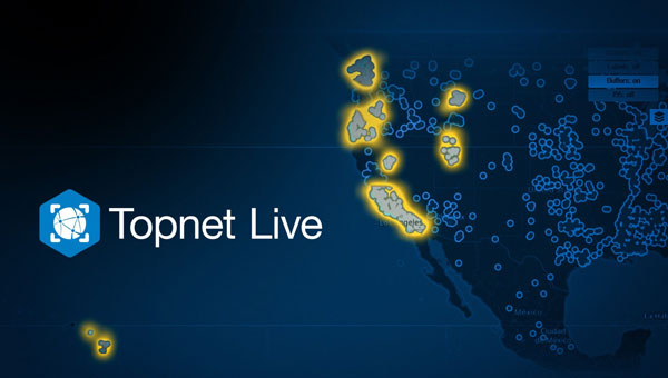
Topcon Positioning Systems has significantly expanded its Topnet Live reference station service, adding 180 full-wave geodetic reference stations across California, Hawaii, Oregon, Nevada, Utah and Washington. This expansion is designed to enhance network corrections, providing centimeter-level accuracy for various industries such as engineering, surveying, construction, and agriculture. The improved service can also benefit specialized applications, including automated mowing, line marking and UAV operations for mapping and delivery in sectors such as the turf industry.
According to Topcon, one key benefit for users is simplified access to globally supported Networked Transport of RTCM via Internet Protocol (NTRIP) network corrections. NTRIP streams GNSS correction data over the Internet, enabling real-time kinematic (RTK) positioning. This technology allows users to achieve high levels of accuracy in their positioning tasks. In addition to NTRIP corrections, the expanded services now include enhanced Differential Global Positioning System (DGPS) coverage, which seeks to improve mapping accuracy.
According to Topcon, Receiver Independent Exchange (RINEX) static files are now more readily available. This enhancement offers more robust static and static kinematic post-processing options. These improvements provide users with more precise positioning data and greater flexibility across a range of applications, from surveying to precision agriculture.
Sabanto has released the Sabanto Steward, a retrofit kit designed to add autonomous functionality to existing tractors. With a simple switch, farmers can seamlessly transition between autonomy mode and standard operator mode.
The Sabanto Steward comprises several key components:
Vehicle Mission Control (vMC): A mobile app that enables users to create, manage, and monitor field operations in real time.
Vehicle Path Finding Module (vPFM): An onboard system that interfaces with the tractor’s steering, power, and hydraulic systems.
Vehicle Operating System (vOS): Software that translates mission control instructions into actual field operations.
Sebanto Steward has successfully executed various field operations across the United States, including mowing, rolling, aerating, rototilling, spraying, seeding, tillage, rotary hoeing and tine weeding. Sabanto’s technology is compatible with various tractor models, including John Deere 5075E, 5100M, 5100E, Fendt 700 Vario and Kubota M5, with plans to expand to more platforms in the future.
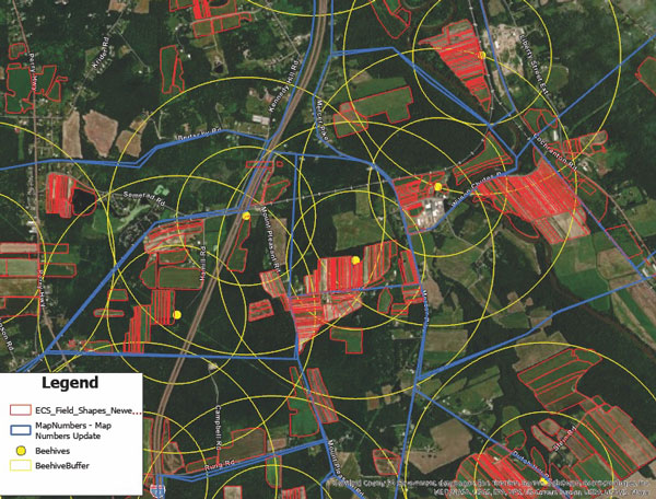
Ernst’s seed production relies on pollinators. Beehives are mapped and placed strategically across the fields to provide full coverage of seed crops. (Image courtesy of Ernst Seeds)
Every Monday and Wednesday, the team at Ernst Conservation Seeds gathers around maps to discuss which fields to harvest, which fields need treatments, and where to plant new crops.
On this 10,000-acre farm near the small town of Meadville, Pennsylvania, the company pioneered the propagation of 180 species of native wildflowers, grasses, and wetland plants to revive degraded land and provide wildlife habitat.
Now, the plants Ernst Seeds propagates are in high demand. Pollinator planting has become a trend worldwide, with the growing realization that flying bugs and birds are key to the survival of three-quarters of the world’s plants, including many we eat. Native plants are also being valued for nature-based solutions to protect soils from erosion and filter pollutants from stormwater.
Across its operation, Ernst Seeds embraces the science of agronomy and the use of geographic information system (GIS) technology to understand native plant species and grow them better, faster, and less expensively.
There’s a lot of experimentation that goes into growing native seeds and designing the right mix for each restoration project. “What we’re doing is going out and looking at existing plant communities to see what species grow together and how they’re doing it,” said Andy Ernst, vice president of Ernst Seeds. “Then there are lessons from our farming failures and successes. We make a lot of discoveries in our fields when we map yield data and the treatments we applied.”
Improving plant propagation
Typically, large farms focus on commodity crops like corn, soybeans, wheat, or cotton. At Ernst Seeds, the growing cycles of 180 species are tracked across 1,300 fields and 15 square miles.
“I realized a long time ago that with the complexity of our farm, we needed software to track it,” Ernst said. His early forays into traditional farm management software products were frustrating as most could not support so many crops. The software lacked the data management and analysis capabilities needed to discern best practices for seed crops no one else was growing.
Then in 2015, Ernst Seeds started using GIS. For operations, the ability to see fertilizer and spray assignments on smart maps helped the company identify places that required more or less treatment.
“There are a lot of accidental experiments when a row is skipped, there’s overlap, or a different chemistry is used,” Ernst said. “When we go out in the field, we can see areas that thrive and other areas that do poorly. With GIS, we can answer why.”
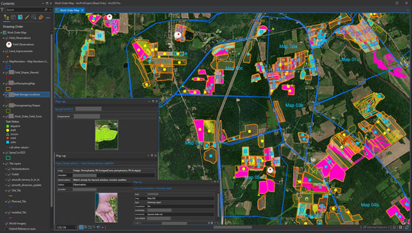
Katy Flaherty, an agronomy expert and the GIS manager at Ernst Seeds, developed a GIS-powered work order management system that guides each phase of production, from planting and fertilizing to applying pesticides and harvesting. The system uses a combination of ArcGIS Survey123, ArcGIS Field Maps, and ArcGIS Dashboards to record data and visualize trends. Flaherty also uses ArcGIS Pro to analyze data from the field, layering it with historical crop records and real-time soil and weather data to uncover correlations.
“When we plan our fields across four counties, there are significant differences in what crops do well from north to south,” Flaherty said. “It’s very spatial aware farming, and that knowledge transfers to recommendations for customers.”
In one instance, this detailed level of monitoring led to a decision to stop using a product that harmed some plants. In another case, improvements in propagation for a species proved so fruitful that smaller plots would meet the demand.
Smart maps guide the company’s planting locations, irrigation system maintenance, and harvesting schedule. Staff use smart maps to track plant maturity and time seed harvests. Unlike corn and soybeans, which can sit in fields for months, some native seeds have only three days of viable harvest. Knowing when and where to harvest is crucial. Ernst Seeds sells 70% of the seeds it harvests every year, putting the rest in the ground for the next crop cycle.
In ArcGIS Pro, administrators and agronomists view short-term plans and historical information. The map views allows them to analyze passes over fields, coverage of treatments, quantities of materials, water drainage, and other variables to inform treatment decisions. (Image courtesy of Ernst Seeds)
Filling gaps and expanding geographic reach
Calvin Ernst, Andy’s father, started the thriving conservation seeds business in 1964 with a Pennsylvania Department of Transportation contract to supply seeds to revegetate highway rights-of-way. Over the next 50 years, the company made wild seed collecting forays across the US to add plants to its offerings. As species count and seed supply grew, so did work with a broader list of customers, including state and federal agencies.
The company has developed seed mixes tailored to specific regions, such as Maryland, northern Virginia, and coastal North Carolina. These seeds are adapted to thrive in the local weather and soil. By choosing native seeds, restoration project managers ensure plants are well-suited to the ecosystem and more resilient to changing climate conditions.
“A simple philosophy is to avoid plants in your seed mixes that would be planted at the southern edge of their historical range,” Ernst said, speaking to the growing need for heat-adapted plants.
This commitment to innovation comes at a cost—it takes time to establish every new species. But insights from GIS can accelerate that timeline.
“It can take seven to 10 years to figure out how to grow something,” Ernst said. “If our observations cut that time down to five years, that’s a major win for us.”
Building native seeds capacity
One of the main challenges with native seed farming, according to Ernst agronomists, is the lack of knowledge of native seed production when compared to conventional row crops.
While the company has typically filled knowledge gaps itself, there have been times when an academic partnership has proved beneficial. For example, Ernst Seeds collaborated with researchers at the Center for Pollinator Research at Pennsylvania State University to identify the mix of flowering plants that could maximize pollinator food and breeding opportunities. The seed mixes developed through this partnership are now used across solar energy farms for revegetation.
The work on developing the right seed mix for solar farms made Ernst Seeds an ideal partner for the Virginia Solar Pollinator Program. Originally, Ernst Seeds was employed on the project by the Virginia Department of Conservation and Recreation to guide a mix of native seeds for Virginia, but that work expanded.
Ernst Seeds experts then worked alongside the Clifton Institute to gather seeds across Virginia, from the Coastal Plain to beyond the Blue Ridge Mountains. They recorded the location and conditions of their findings using a GIS-powered mobile app on their phones. This knowledge will help in planting along corridor projects, such as land beneath the electric transmission lines that will deliver energy from solar farms in rural areas to businesses and households in urban centers.
From its start with solar projects, the program evolved into the Virginia Native Seed Pilot Project to launch a native seed industry in Virginia. The program identifies local growers who can produce native seeds at a commercial scale and shows them how data from GIS helps guide best practices.
Tractor operators record their observations and have access to historical data as they work the fields. (Image courtesy of Ernst Seeds)
“Creating a GIS-centric culture at Ernst has changed how managers and operators work the fields,” Flaherty said. “We aren’t only looking at maps and numbers, we’re utilizing and making the data work for us every day.”
A data-driven approach to farming can be tough to instill in farmers working the same fields with the same approach for decades.
“Early on, we had pushback about the need to collect different information,” Ernst said. “Then in one meeting, we had a big lights-come-on moment when the answers we needed came from the data they’d been collecting. The guys were saying, ‘I know what we did there,’ but when we looked at the records their memory wasn’t as good as they thought it was.”
The GEODNET Foundation has received more than $2 million of strategic investments from new investors including CoinFund, Pantera, VanEck and Santiago R. Santos. The additional funds raised will support the Foundation’s near-term objectives of decentralization and developer accessibility.
GEODNET, the company’s blockchain-based global navigation network, has more than 5,000 GNSS reference stations added to its real-time kinematic (RTK) network, designed to enhance location and intelligent autonomy services. Standard GPS is typically off by two meters; however, devices connected to GEODNET’s global RTK network are designed to achieve instant accuracy within 1 cm to 2 cm.
The network can be used in agriculture, UAVs, consumer robotic devices and commercial global positioning services such as PPP precision point positioning (PPP), automotive-focused PPP-RTK services and low-Earth orbit satellite tracking.
GEODNET has more than 4,000 registered reference stations in more than 2,500 cities across 120 countries. It is designed to provide robust precision navigation systems to a variety of industries, including self-driving cars, agriculture, consumer robots, and more. An additional 2,000 stations are being delivered and installed.