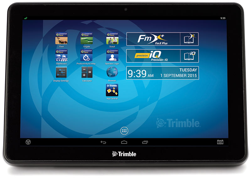
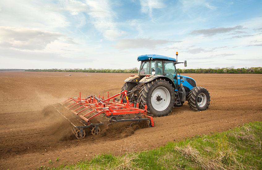
Trimble has added several new third-party apps to its Android-based Trimble TMX-2050 display for precision agriculture.
The new apps fall into several categories, including:
Diagnostic tools to identify and address implement error codes.
Fertilizer calibration charts for various brands of spreaders.
Identification of nutrient deficiencies.
Planter adjustment recommendations for various planter brands.
PDF reader.
Work order and documentation-based software applications for agriculture.
The apps are available for download from App Central marketplace on the TMX-2050 display. App Central provides farmers with enhanced flexibility to install apps, view descriptions and images, report issues, connect with developer partners and stay current with on-demand updates, Trimble says in a news release. Users can search and find the apps most useful to their farm operations, language and regional compliance requirements.
“As we continue to add third-party apps on our TMX-2050 display, we are providing farmers with more localized choices so they can select the tools that best fit their machines, applications and regional needs,” said Pierre-Andre Rebeyrat, marketing director for Trimble’s agriculture division. “These apps can enable farmers to obtain needed information more easily and quickly, leading to more efficient management of their farm operations.”
Every new TMX-2050 display solution includes wireless connectivity allowing farmers to view ongoing field activities, real-time commodity prices, real-time weather conditions to guide irrigation and field deployment decisions, and other valuable task information in the Connected Farm dashboard. It also enables wireless data transfer of as-applied maps and other field activities such as planting, spraying or harvesting, simplifying the overall management and transfer of farm data files.
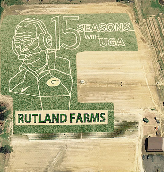
Vellidis’ precision agriculture class helped develop the maze using GPS technology. (Photo courtesy University of Georgia)
University of Georgia precision agriculture students used GPS to design a corn maze in honor of football coach Mark Richt.
George Vellidis, a UGA crop and soil sciences professor, gave his precision ag students the opportunity to experience GPS technology firsthand by having them develop a corn maze at a nearby farm.
“I’ve been teaching precision agriculture at the UGA Tifton Campus since 2003. We’ve been teaching GPS from day one because GPS is a critical part of precision agriculture. Everything we do with precision agriculture has coordinates, so we can collect our data through GPS,” Vellidis told the newspaper. “It’s a great experience for the students to go out and help with the corn maze. They get to do a fun activity while learning how to use GPS.”
Covering 6.1 acres, the maze is the biggest ever constructed at Rutland Farms, and received national coverage on ESPN.
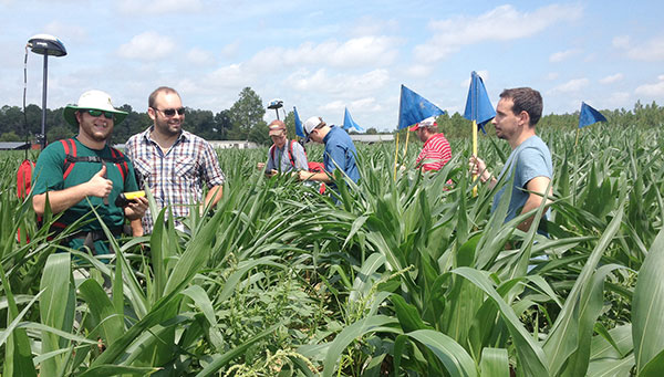
Students have been impressed by how easy GPS technology is to use and how beneficial it can be to farmers. “I’ve used it to go back after we’ve already installed moisture sensors earlier in the season and I’ve used it to find the sensors much later in the season,” Sydni Barwick, Vellidis’ student and student worker in irrigation for UGA Cooperative Extension.
“When, for example, a corn crop is eight feet high, you can’t see across that field, so there’s no way to find the sensors without GPS. Using the (GPS) system is great for things like that because it has an accuracy of about 3 feet,” she said.
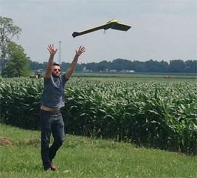
Flying at Molly Caren Agricultural Center in the Ohio State project.
Clark State Community College in Springfield, Ohio, now includes flying unmanned aircraft systems (UAS) as part of its new precision agriculture program, according to the Ohio/Indiana UAS Center (UASC). The new program is designed to prepare students for employment with companies using geospatial technologies, including geographic information systems (GIS) and GPS applied to agricultural production or management activities, such as pest scouting, site-specific pesticide application, yield mapping, or variable-rate irrigation.
Clark State will process and analyze the UAS-collected data. Students will learn how fly and use UAS-gathered data to determine the overall health of crops and manage a range of farming issues, including how to spot early diseases, identify specific pest infestations, and determine fertilization requirement.
The Federal Aviation Administration (FAA) approved the Certificate of Authorization (COA) for UASC earlier this year. The center is working to expand the number of FAA-approved Certificates of Authority for research across Ohio, and operates 11 COAs in support of public entities and universities with an additional 17 COAs pending at the FAA.
Ohio State Sensor Research
In another UASC project, UASC and The Ohio State University initiated regular flight operations in July at Molly Caren Agricultural Center to research various types of UAS sensors to improve agricultural productivity and enhance environmental management practices through improved nutrient use efficiency.
3D Aerial, a UAS business in Dayton, Ohio, pilots the small 1.5-lb fixed-wing aircraft for this project. Data gathered is part of a research and development effort focused on noninvasive assessment of crop health.
“This data will be analyzed and results will be used in support of research on cropping systems and assessment of environmental factors affecting crop growth,” said Scott Shearer, professor and chair of the Food, Agricultural and Biological Engineering at Ohio State. “In addition to precision agriculture experiments, this research will help enhance water quality by better understanding how best management practices may impact surface and ground water quality.”
The UAS market is projected to be an $82 billion industry with a potential to create approximately 100,000 jobs nationally over the next 10 years.
AGCO and Trimble are partnering to deliver wireless connectivity between AGCO’s VarioDoc and AgCommand systems and the Trimble Connected Farm solution. The functionality is expected to be available to customers in North America in September and in Europe, Africa and the Middle East in the fourth quarter of 2015. AGCO is a worldwide manufacturer and distributor of agricultural equipment and infrastructure.
The collaboration allows customers to access their AGCO machine data via AGCO’s telemetry product AgCommand, as well as their agronomic data through AGCO’s VarioDoc task file management platform, from within the Trimble Connected Farm dashboard. This deeper integration of AGCO and Trimble technologies delivers a more streamlined approach to total farm management, simplifying the grower’s ability to access and act on live machine and task data within a single, Web browser-based user interface, the companies said in a statement.
“The inclusion of AGCO’s AgCommand information into Connected Farm aligns well with Trimble’s continued focus on providing a complete solution for growers to manage a mixed fleet of vehicles and implements,” said Joe Denniston, vice president of Trimble’s Agriculture Division. “AGCO customers now have access to one central location in Connected Farm for monitoring their farm operations including fleet data, rainfall and weather information, commodity quotes, and irrigation monitoring to enable improved decision making from the office to the field.”
“This collaboration gives our customers easier access to their operational data for enhanced productivity, mobility and decision making,” said Eric Hansotia, senior vice president, Global Harvesting, Crop Care, Advanced Technology Solutions and Dealer Tech Support at AGCO. “Strategic development with platforms like Connected Farm gives growers a single location from which to monitor their entire operation.”
The development expands on the February 2014 announcement of the connection between Trimble’s Farm Works Software and VarioDoc. This new integration will give Trimble customers the option to sync their task data sent via VarioDoc in either Farm Works or Connected Farm.
The integration between Trimble’s Connected Farm and AGCO’s AgCommand will be the first to utilize AGCO machine data via the AgCommand API (Application Programming Interface). The API will open globally in the fourth quarter of 2015 to developers and service providers who wish to incorporate machine data into custom applications and tools for growers. This offers more points of access to end users, allowing AgCommand data to be integrated into the grower’s farm management platform of choice.
Trimble joins AGCO’s growing list of partners that are part of AGCO’s Fuse Technologies open approach to precision agriculture and precision machine management.
By Denis Parrot Guest Columnist, Survey Scene newsletter
I recently read an article by David Doyle entitled “Why Doesn’t my Centimeter Match Your Centimeter?” (May Survey Scene), which painted an interesting portrait of the widespread use of GNSS-based data collection systems. Nowadays, almost everyone can claim to have surveys with centimeter or sub-meter accuracy anywhere in the world, which before was achievable only by a few rare specialists. In many cases, the positions do not always fall at the right place when they are integrated into geographical information systems (GIS). Unfortunately, it is often at this stage that we call on a specialist! The key is in the reference system, also known as datum.
Even if it can become relatively complex when it comes to details, the concept of a reference system when using the GNSS system is essentially identical to conventional surveying techniques. A surveyor always used a reference station for his survey using his theodolite. He stringently maintained his control point network on the territory being surveyed. All his surveys were in reference to his control network (points that are part of a series of controlled polygons). If certain polygons were not well linked to the rest of the network, integration with centimeter precision into the computer-assisted design program (or his geographical information system [GIS]) would be problematic, or even impossible, for the lots linked to the erroneous polygons. And this is exactly what happens with the GNSS system; if the reference is overlooked, GIS integration becomes a real problem.
Without realizing it, GNSS users also use a reference network. If they work in RTK (differential positioning), they use either a VRS (Virtual Reference System) or a station network that sends corrections. In general, these two systems are based on a national reference system (geocentric or not). Users can also use a portable base that they install themselves as needed. When they enter a coordinate into this portable station, they become responsible for the reference system used. During post-processing, the problem remains the same. A position must be entered for the base station and the reference must be known (i.e., the datum).
Example of positions that do not fall at the right place when they are integrated into a geographical information system (GIS).
If they use satellite-based augmentation systems (SBAS), such as the private Omnistar, Veripos or StarFire systems, these systems are generally referenced by a geocentric system (which nowadays includes a temporal drift) defined by international bodies (IGN in France, which maintains, along with several research centers, the International Terrestrial Reference Frame (ITRF)). Today, this method of positioning is known as PPP or precise point positioning.
These different GNSS positioning methods, therefore, do not use the same reference! Each may provide highly accurate coordinates. However, these coordinates are only accurate with regard to their reference. Although this concept may seem very simple, in reality the increasingly common use of these systems by non-specialists often produces strange results.
Below are a few examples of uses that may lead to confusion with reference systems, in terms of “compared with what?”:
A farmer who carries out micro-topography to analyze his fields is pleasantly surprised by the level of altimetric precision he can achieve (within a few cm), using a “single-frequency” receiver. However, when he tries to juxtapose two fields, he may discover an altimetric deviation of up to 2 meters. The reason for this is quite simple: he systematically used local base stations with average coordinates taken in the field as the base coordinates. Normally, he uses one base per field. By not taking into account the consistency of the coordinates for the base stations, without realizing it, this farmer was creating independent references for each of his fields. It is obvious that if the analysis had been done individually on each field, he would not have seen any problem. It is when the two juxtaposed fields are integrated that problems arise.
Photo courtesy of Effigis.
In Quebec, a surveyor uses a Department of Energy and Natural Resources station as a source for RTK differential corrections. This system is referenced to the NAD83 SCRS coordinates system. When he tries to integrate his survey points using the conventional method, which are based on the original NAD83 coordinates system, he will notice inconsistencies of a few to several centimeters. These two coordinate systems (NAD83 ≠ NAD83SCRS) may have inconsistencies of several centimeters from each other.
In Canada, an agronomist surveys the position of trees in the city using a portable GNSS system with an SBAS corrections system. Once the survey has been completed and he integrates the position of the trees into the city’s GIS, these all seem to be off by +/- 1.5 m. The SBAS reference systems are all geocentric (within +/- several cm) compared with the NAD83 SCRS system, which is positioned +/- 1.5 m from the Earth’s center!
These three examples illustrate the type of error commonly found in the “reference system” category. The issue here is not GNSS system performance, since we are assuming that the positions obtained are accurate versus the chosen reference. Neither does the issue concern the variations between different reference systems, or the methods or precision of transformations between one reference system and another (this topic is very broad).
Lastly, we should find the answer to the question “But compared with what?” in what we commonly call “metadata.” Regarding GNSS position, this is information related to creating positions: the reference system used, statistics regarding the position estimate, date, different dilution of precision (DOP) values, type of GNSS signal used, etc.
For your next delivery, simply mention “Precise, but compared with what?” or deliver your positions along with full metadata!
Denis Parrot earned a degree in surveying and mapping from Université Laval in 1981, and began his career working in those fields around the world for five years. He then completed graduate studies in Fredericton, New Brunswick, where he earned a master’s in satellite geodesy. With a passion for his area of expertise, Parrot has been involved since 1991 in a host of projects that employ geospatial information to meet the specific needs of various markets and users. He is currently president at Effigis and responsible for the OnPOZ Product division, including the commercial aspect and R&D activities.
This column originally appeared as a blog at the Effigis Geo Solutions website, and is shared with permission.
NORAC provides advanced automated boom height control technology for the global agricultural marketplace. Its current product line includes systems to precisely maintain a spray boom height above the top of the crop or the ground to ensure optimum application of needed fertilizers and plant protection products.
The agreement marks the third precision agriculture-related purchase Topcon has made since November 2014. It adds an additional engineering and manufacturing facility in Canada and raises the total number of Topcon employees dedicated to precision agriculture solutions to more than 700.
“For more than 40 years NORAC has created innovative solutions to improve efficiency on the farm,” said Ray O’Connor, president and CEO of Topcon Positioning Group. “Its automated boom height control technology has transformed the use of agricultural sprayers. We are excited to unite with another precision agriculture leader, especially one that has established its leadership in a way that mirrors the growth of Topcon — by being the first to bring best-in-class technology to the market.”
“It’s another example of our optimism for investing in the agricultural marketplace,” said O’Connor. “Topcon is committed to developing automation and management solutions that bring the power of the Industrial Internet of Things (IIoT) to every farm.”
“We are thrilled to have the opportunity to join the Topcon family,” said Bill Strelioff, president and CEO of NORAC Systems International. “NORAC and Topcon have collaborated well in numerous precision agriculture development projects and know that our synergistic technologies and distribution channels make this a great fit. But just as importantly, we recognize that our company cultures are very closely aligned. That’s the real key to multiplying the benefits of this union.”
Founded in 1974, NORAC pioneered automated boom leveling, and currently enjoys a leading market share within the agricultural industry. In addition to the headquarters in Saskatoon, Saskatchewan, Canada, three branch offices include NORAC, Inc. (Minnesota, U.S), NORAC Europe sarl (Guéreins, France) and NORAC Trading (Shanghai, China).
“We are excited to welcome the skilled employees at the world-class facilities of NORAC to the precision agriculture team at Topcon,” said Albert Zahalka, president of Topcon Precision Agriculture. “As a global leader for boom leveling, NORAC will add considerable strength to our original equipment manufacturer (OEM) offering, and is an ideal complement to our extensive portfolio of innovative precision agriculture solutions.”
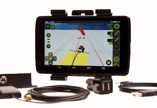
The MachineryGuide package with antenna, receiver and guidance software.
MachineryGuide is a new GPS guidance system for Android that gives farmers the ability to use their smartphones for precision guidance.
With the help of MachineryGuide, the cultivated area and overlaps can be displayed. The guidance application helps farmers in edging along the ideal track by gearing to straight reference lines.
With the application and an antenna from MachineryGuide, farmers can have a simple precision guidance application to improve yield growth, increasing efficiency. Also, fertilizer and pesticide use can be optimized, while machine costs and work hours can be lowered by up to 10 percent, the app designers said.
The application is aimed at managers of small- and medium-sized farms and can be used on a smartphone or tablet. A demo can be downloaded from GooglePlay — the free version can not connect to a real GPS device, but all the functions of the program can be tested.
MachineryGuide sells the software separately; a GNSS receiver + antenna separately; and a package bundle that includes software, GNSS receiver and antenna. The antenna is capable of receiving and processing free corrections (EGNOS, WAAS).
Marketsandmarkets.com is offering a new report on the precision farming market, with forecasts to the year 2020. The report covers various technologies and components, including GNSS.
The report is titled “Precision Farming Market by Technology (GPS/GNSS, GIS, Remote Sensing & VRT), Components (Automation & Control, Sensors, FMS), Application (Yield Monitoring, VRA, Mapping, Soil Monitoring, Scouting) and Geography – Global Forecasts to 2020.”
According to marketsandmarkets.com, “Precision farming is growing rapidly from its infancy towards maturity. Driven by advancements in data management, precision farming has a remarkable impact on traditional approaches to farming. Applying technological developments in data collection and geo-location tracking, precision farming uses technology to optimize yield and detect operating efficiencies as well as deficiencies. Precision farming applications guide farmers about the right time to plant and harvest, and the amount of fertilizers and pesticides needed for better yield production. This information helps cut down input costs, fuel usage, and labor, and negate the environmental impact. Farmers across the globe have been benefitted due to innovations in precision agriculture.
“Major drivers for this market are augmented yield and profitability, which are contributing factors for farmers to opt for precision farming; other drivers like energy and cost saving, and government assistance have also been contributing to the market growth. Major restraints like high initial investments, and lack of awareness and their impact analysis are also covered under this study.
“The total precision farming market size is expected to grow at a CAGR of 12.2% from 2014 to 2020 and reach $4.55 billion by 2020. The report analyzes the precision farming supply chain, giving a very clear insight of all major segments and supported segments to the industry. The report also provides a detailed scrutiny of the Porter’s five force analysis for the market. All five major factors in these markets have been quantified using internal key parameters governing each of them.
“The report also includes company profiles of leading players in this industry with their recent developments and other strategic business activities. The competitive landscape section of the report entails key growth strategies and detailed market share analysis of key industry players. Some of the major players in the precision farming market are AgJunction Inc. (U.S.), Ag Leader Technology (U.S.), Dickey-John Corporation (U.S.), Teejet Technologies (U.S.), Deere & Company (U.S), Trimble Navigation System (U.S.), Precision Planting Inc. (U.S.), ACGO Corporation (U.S.), Topcon Precision Agriculture (U.S.), and Raven Industries Inc. (U.S.).”
Topcon Positioning Systems has received a national exemption from the Federal Aviation Administration (FAA) that allows for operation of its unmanned aerial system (UAS) in the United States. The exemption covers the operation of the Sirius Basic and Sirius Pro for aerial data collection.
The Sirius Pro and Sirius Basic systems are designed to produce accurate solutions for the automated mapping of a wide range of sites — regardless of terrain — including construction sites, mines and quarries. The UAS are designed for land surveying, transmission line and pipeline inspection, and agricultural operations such as field mapping and livestock management. With the Sirius Pro model, Topcon eliminates the need for ground-control points by combining real-time kinematic (RTK) GNSS solutions with precision timing technology to provide accurate mapping results, Topcon said.
“This exemption is exciting news for the U.S. marketplace,” said Eduardo Falcon, executive vice president and general manager of the Topcon GeoPositioning Solutions Group. “It allows Topcon to be a resource for end-users and provide UAS demonstrations and training. Aerial data collection has a strong impending impact on all the industries we serve, and the possibilities for survey, construction, and agricultural applications are seemingly limitless.
“Building on the success the Sirius models have already seen in the European and Australian markets, this exemption allows Topcon to expand on that momentum in the U.S.,” Falcon said.
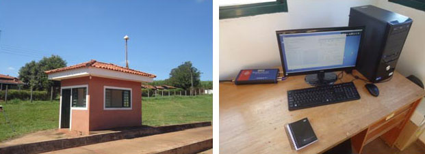
The monitoring station in Brazil uses a Septentrio PolaRxS receiver to monitor the ionosphere, a Septentrio AsteRx3 to perform tests static and kinematic tests, and three RTK Altus APS3 receivers (one as a base station and two as rovers.)
After 27 months of intensive research, a project team funded under the European Union’s 7th Framework Programme has come up with a solution to counter the problem of ionospheric disturbance affecting GNSS signals.
The CALIBRA project recently showcased a commercially applicable approach to mitigate the phenomenon’s impact on high-accuracy GNSS positioning techniques. In two demonstrations, the project’s newly developed algorithm was successfully tested in actual precision agriculture and offshore operations.
Solar flares can cause ionospheric disturbance, a sudden increase in radio-wave absorption that often delays the propagation of signals and ultimately affects positioning. The problem has kept researchers busy for years.
The CALIBRA project team has been participating in this global research effort by focusing on Brazil, which is one of the most exposed regions due to its proximity to the magnetic equator. Add to this that the sun is at its peak of activity since it entered its new 11-year cycle in 2010.
The project achieved three main milestones. First, the team confirmed that ionospheric scintillation and variations in total electron content (TEC) had a direct impact on the functioning of high accuracy GNSS techniques, such as Precise Point positioning (PPP) and real-time kinematic (RTK) positioning. Then a suitable metric was established to characterize these ionospheric disturbances. Finally, the project produced a short-term empirical model for forecasting TEC and scintillation. A regional TEC map was developed which proved advantageous for use in Brazil and, to counter scintillation, a number of approaches for the mitigation of this phenomenon were proposed and their benefit demonstrated.
The project exploited the CIGALA-CALIBRA network and database — a network of ionospheric scintillation monitor receivers with a web interface (the ISMR Query tool), which collects more than 10 million observations on GPS, GLONASS, Galileo, BeiDou and other global navigation systems every day. Since it was launched in December 2014, this data has helped assist users from more than 20 countries because of the software’s visualization and mining techniques.
In light of this success, CALIBRA partners INGV (Istitute Nazionale di Geofisica e Vulcanologia) filed a patent for their forecasting model, and a new spin-off company — SpacEarth Technology — was set up. SpacEarth’s main purpose is to secure the software’s commercialization in relevant applications and services, while also improving and adapting it to evolving market needs.
The project’s results promise to considerably reduce downtime and financial losses caused by ionospheric disturbance in Brazil and other regions of the world. Learn more about the project here.
The TeeJet Matrix 430 is a low-cost GNSS guidance system featuring a graphical, touchscreen user interface that allows for fast setup and intuitive operation. The system is designed for a wide range of field applications including spraying, spreading, tillage and solid seeding.
The Matrix 430 features a 4.3-inch/110-mm high-contrast, full-color display for excellent visibility, even in bright light conditions, TeeJet said. It contains an integral GNSS receiver that supports both GPS and GLONASS signals with a choice of two available antennas for enhanced performance in a wide range of geographies.
Other features include: return-to-point, coverage mapping, field area measurement, applied area alert, elapsed time counter, simple job reporting, and a choice of four guidance modes: Straight AB, Curved AB, Center Pivot, and Last Pass.
“The Matrix 430 builds upon our highly successful and proven CenterLine 220 guidance product while providing an enhanced user interface and expanded capabilities,” said Tim Stuenkel, global marketing manager with TeeJet Technologies. “This product is designed for the grower who wants a simple, affordable guidance system — whether they are a first time buyer or experienced user of GNSS guidance products.”
TeeJet Technologies manufactures a comprehensive line of products including agricultural spray nozzles for various pesticide/fertilizer applications, boom components, valves/manifolds, strainers, and spray guns, as well as GPS guidance systems, sprayer control systems, ISOBUS job computers, assisted steering systems and other precision farming products. In addition, TeeJet Technologies continues to invest in research and development to advance precision application and control technology.
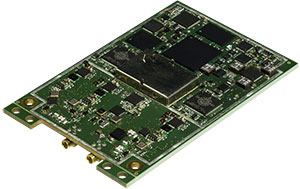
Septentrio has launched its next-generation dual-antenna GNSS receiver, the AsteRx 4 OEM. The AsteRx 4 OEM is a multi-frequency, dual antenna receiver that incorporates the latest innovative GNSS tracking and positioning algorithms from Septentrio. It offers users in the marine, machine control and agricultural industries precision, accuracy, reliability and ease of use, the company said.
Thanks to Septentrio’s positioning engine, which uses advanced multipath and ionosphere modeling algorithms, the AsteRx4 offers robust positioning scalable from meter to centimeter accuracy. Together with precise heading and reliable error estimates, the AsteRx 4 OEM functions in tough conditions on land, at sea or in the air.
Use of all available constellations (GPS, GLONASS, BeiDou, Galileo) provide the operator with a reliable solution even in obstructed areas such as in narrow city streets or at the corners of large structures, Septentrio said. The AsteRx4 OEM features the full range of positioning techniques from stand-alone to real-time kinematic (RTK).
For users who operate in more remote regions of the globe, the AsteRx4 OEM supports Veripos and Terrastar correction PPP services. Furthermore, the receiver features special interference mitigation technology which filters out ambient intentional and unintentional RF interference.
The AsteRx4 OEM is straightforward to set up and integrate with existing systems, Septentrio said. It has the similar hardware interface as earlier AsteRx receivers, and supports the same open and well documented command and binary output format. Users will be able to operate their receiver without special configuration software by using the very accessible web interface, which is available via network and USB connections.
“AsteRx4 incorporates many powerful improvements based on practical difficulties our customers face in the field every day,” said Jan Van Hees, vice president of Business Development, Septentrio. “We are particularly proud of the solutions for interference robustness that we have incorporated into our new ASIC, the GReCo4; the solid and reliable positioning algorithms that result from taking the receivers into the most extreme environments and from focusing not only on accuracy, but on reliability of the position solution.”
The AsteRx4, along with all the AsteRx family of receivers, will be on display at booth W40 for the duration of Ocean Business 2015 starting April 14 at the National Oceanography Centre, Southampton, UK.