Tag: product showcase

  • Launchpad: Datalogger, receivers, timing

    Launchpad: Datalogger, receivers, timing

    A roundup of recent products in the GNSS and inertial positioning industry from the November 2019 issue of GPS World magazine.
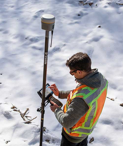

    SURVEYING & MAPPING

    IMU-RTK receiver

    Increases GNSS availability and reliability

    Photo: CHC Navigation
    Photo: CHC Navigation

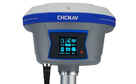
    The i90 IMU-RTK GNSS series receiver is designed to dramatically increase GNSS real-time kinematic (RTK) availability and reliability. The i90 is powered by the company’s latest inertial measurement unit (IMU) and RTK technology to provide robust and accurate GNSS positioning in any circumstances. Unlike standard micro-electro-mechanical (MEMS)-based GNSS receivers, the i90 GNSS IMU-RTK combines a high-end calibration and interference-free IMU sensor with a state-of-the-art GNSS RTK engine and advanced GNSS tracking capabilities. The i90 is designed to increase the productivity and reliability of survey projects, with no complicated calibration process, rotation, leveling or accessories are necessary. A few meters’ walk will initialize the i90 internal IMU sensor and enable RTK survey in difficult field environments. The i90 GNSS automatic pole-tilt compensation boosts survey and stakeout speed by up to 20%.

    CHC Navigation, chcnav.com
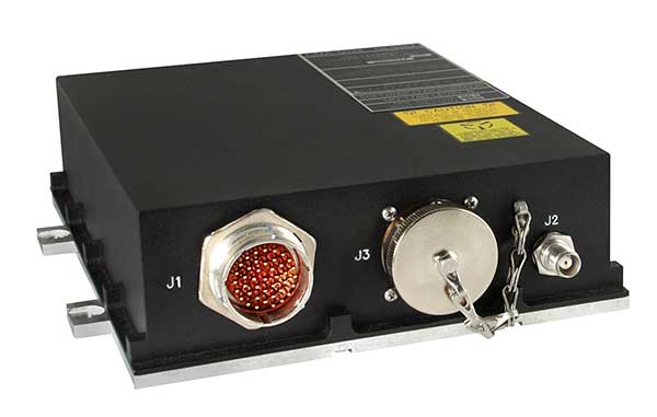
    GNSS/INS System

    Both accurate and rugged for machine control, logistics

    The AsteRX-SBi has a rugged housing, making it suitable for machine control and other outdoor uses. (Photo: Septentrio)
    The AsteRX-SBi has a rugged housing, making it suitable for machine control and other outdoor uses. (Photo: Septentrio)

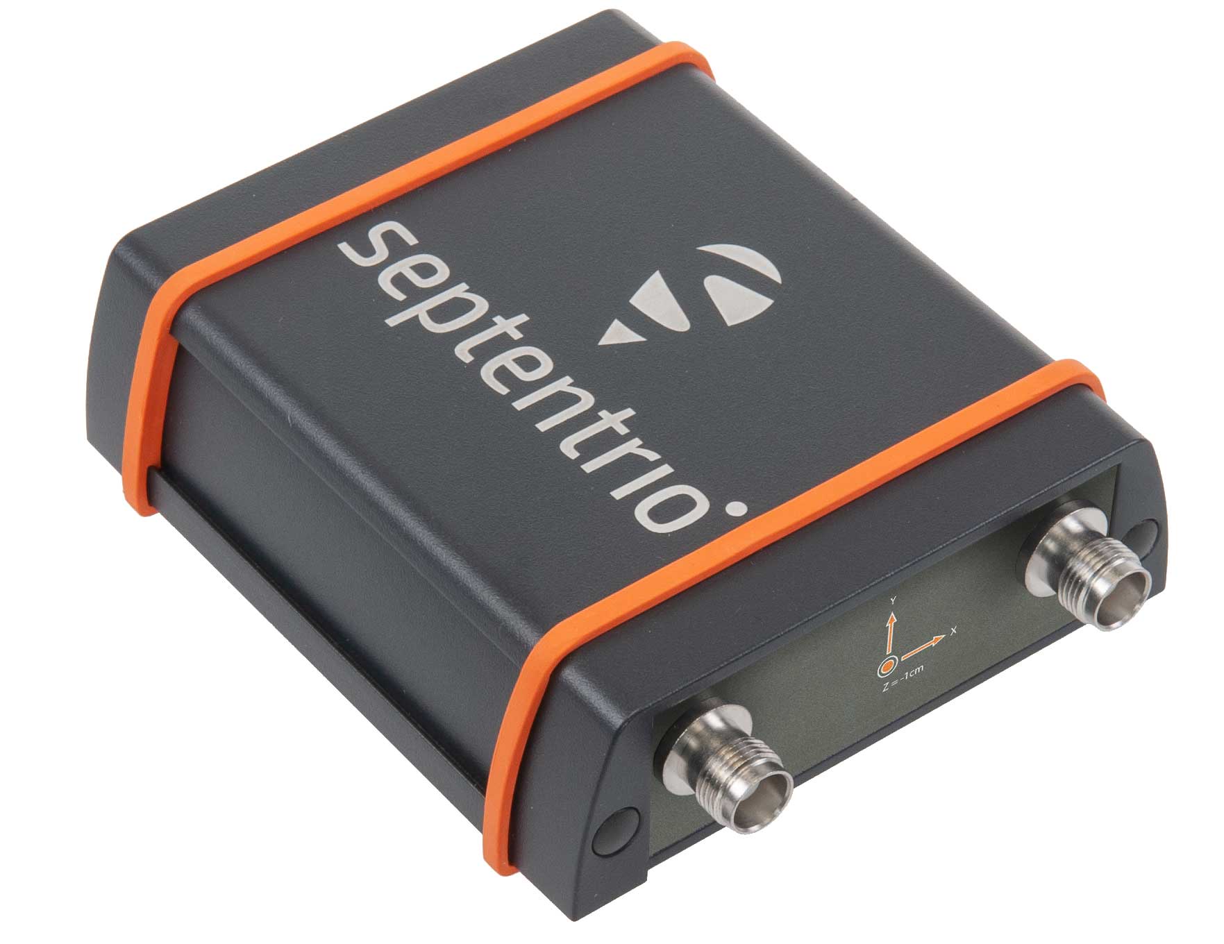
    Septentrio has expanded its GNSS/INS portfolio with the AsteRx SBi, a new housed GNSS/INS receiver. The ruggedized AsteRx SBi fuses high-accuracy GPS/GNSS with a high-performance inertial sensor to provide reliable positioning and 3D orientation for machine control and logistic applications. Within its rugged, waterproof enclosure, a high-performance GPS/GNSS is coupled with an industrial-grade inertial sensor to provide high-accuracy, reliable positioning and 3D orientation (heading, pitch, roll). Offering the flexibility of either single or dual antenna, the AsteRx SBi is designed for quick and easy integration into any machine monitoring or control system. Reliable location and 3D orientation data is streamed with a high update rate and constant low latency. Septentrio’s reliable centimeter-level positioning is based on true multi-frequency, multi-constellation GNSS (GPS, GLONASS, Galileo, BeiDou, QZSS) technology.

    Septentrio, septentrio.com

    Scanning System

    For surveying, construction

    Trimble X7 scanner in the field. (Photo: Trimble)
    Trimble X7 scanner in the field. (Photo: Trimble)

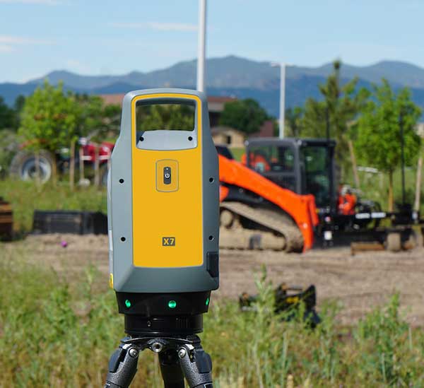
    The Trimble X7 laser scanning system is designed for surveying, construction, industrial and forensic applications. It enables professionals to quickly and easily capture precise 3D scanning data to produce high-quality deliverables. The X7 features Trimble X-Drive technology, survey-grade self-leveling and a smart calibration system. It integrates streamlined workflows to provide automatic registration of point-cloud data in the field with Trimble Registration Assist, bringing scans together through self-leveling inertial measurement unit technologies and cloud-based software.

    Trimble, trimble.com

    City mapping

    Service offered for Europe

    The Bluesky MetroVista range includes high-resolution imagery combined with high-accuracy, wide-scale 3D models. (Image: Bluesky)
    The Bluesky MetroVista range includes high-resolution imagery combined with high-accuracy, wide-scale 3D models. (Image: Bluesky)

    The MetroVista city mapping service for Europe incorporates the Leica CityMapper hybrid airborne sensor designed for 3D city modeling and urban mapping. The sensor includes a vertical camera and survey-grade oblique cameras, and incorporates lidar to accurately collect elevation and infrared data. The MetroVista range includes high-resolution imagery combined with high-accuracy, wide-scale 3D models. CityMapper has already been used to capture MetroVista data for cities across the United Kingdom, including London, Manchester, Newcastle and Bristol.

    Bluesky International, bluesky-world.com


    OEM

    Simulation solution

    Updated for high-accuracy market

    Photo: Spirent
    Photo: Spirent

    The enhanced GSS9000 series GNSS constellation simulator has been updated to provide significantly improved capability, flexibility and performance to meet the test needs of high-performance navigation systems. It doubles the number of supported channels (320 in a single chassis) while maintaining its full performance specification in key areas such as signal iteration rate and low latency under maximum signal dynamics. These attributes, together with the ability to produce a comprehensive range of emulated multi-GNSS, multi-frequency RF signals, enables full and future-proofed testing of advanced applications. Greater signal flexibility is also built into the enhanced GSS9000 through its open application program interface (API) and flexible architecture. This delivers a highly sophisticated arbitrary waveform generator (AWG) capability.

    Spirent Communications, spirent.com

    NavIC support

    Added to constellation data service

    Image: RX Networks
    Image: RX Networks

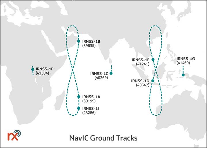
    Rx Networks has added NavIC constellation support to its real-time and predicted-assistance data service. The company’s technology partners — semiconductor vendors, mass-market mobile device manufacturers and network operators — now have global support for all satellite navigation systems and L1 satellite-based augmentation systems (SBAS) for any region around the world. Used daily by more than two billion devices, Rx Networks data is delivered via ephemeris in RINEX and via the Location.io interface, with predictions in SP3. Predictions for NavIC via the Location.io platform will be added in the first quarter of 2020.

    Rx Networks, rxnetworks.com

    MEMS timing

    For rugged GNSS applications

    Endura MEMS timing products. (Photo: SiTime)
    Endura MEMS timing products. (Photo: SiTime)

    Endura micro-electro-mechanical system (MEMS) timing solutions are designed for aerospace and defense applications including precision GNSS. They provide high performance in harsh conditions such as severe shock, vibration and extreme temperature. SiTime offers customers 5 million possible part numbers that can be created from 17 programmable products. Solutions accommodate 4 parts per trillion per g force of acceleration (50 times better than quartz); support for –55° C and +125° C operation; timing specifications conforming to MIL-PRF-55310; and Endura Super-TCXOs (temperature compensated oscillators) for use in GNSS applications.

    SiTime, sitime.com

    GNSS RF Simulator

    Record and playback system

    Portos Team paired with the Ninja. (Photo: IP-Solutions)
    Portos Team paired with the Ninja. (Photo: IP-Solutions)

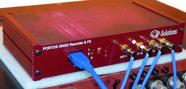
    Portos Team is a new GNSS RF signal record-and-playback system. It can record and play back — or simulate —multi-frequency, multi-system GNSS signals when paired with the company’s Replicator. It can do the same for CRPA signals when paired with the company’s Ninja. The Portos itself can also operate as multi-frequency or CRPA front end for a GNSS software receiver.

    IP-Solutions, ip-solutions.jp
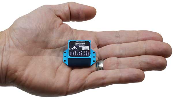
    UWB module

    For real-time location systems

    Photo: Decawave
    Photo: Decawave

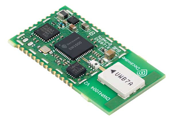
    The DWM1004 module targets time difference of arrival (TDoA) tag applications that require years of battery life and a compact design. Based on the DW1000 chipset, the DWM1004C offers high-accuracy, real-time-location capability with a 6.8-Mbps data rate. It delivers more than five years of battery life. Real-time location systems (RTLS) enable managers to have a real-time view of their operations through data collected from connected objects such as tools, pallets, forklifts, badges and collars. The DW1000 is immune to multipath fading, with 2-centimeter precision in indoor environments.

    Decawave, decawave.com


    TRANSPORTATION

    RTK GNSS Rover

    GNSS for a moving vehicle

    Photo: Drotek
    Photo: Drotek

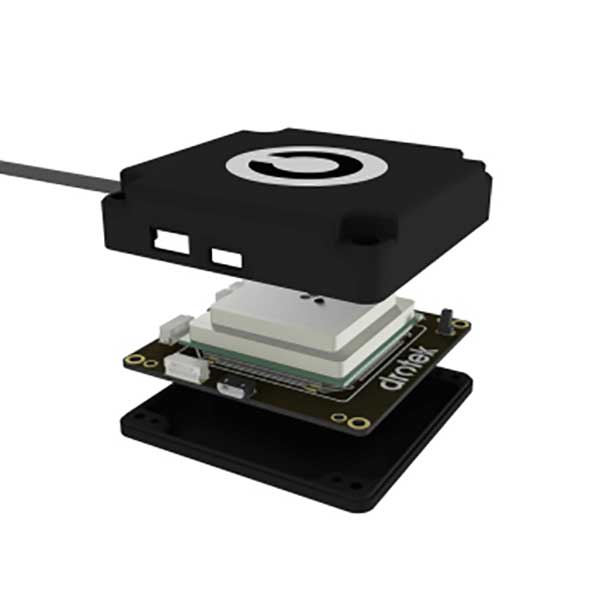
    The F9P Sirius RTK GNSS rover is designed to be mounted on a moving vehicle. The u-blox ZED-F9P module inside provides 1-cm position accuracy, a convergence time under 10 seconds and a navigation update rate up to 20 Hz. The rover has a built-in active antenna patch. It receives GPS, Galileo, Beidou and GLONASS signals, providing additional accuracy. It is designed to fit most setup designs as well as integrate easily into a vehicle. Its six-pin JST-GH connector makes it plug-and-play with the Pixhawk Pro 3 autopilot.

    Drotek Electronics, drotek.com

    GNSS Datalogger

    Accuracy for automotive testing

    VBOX Touch datalogger. (Photo: Racelogic)
    VBOX Touch datalogger. (Photo: Racelogic)

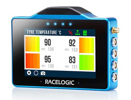
    The VBOX Touch is a highly flexible GNSS datalogger with enhanced accuracy. The powerful hardware can be used diverse automotive tests such as acceleration, braking, speed verification, tire temperature monitoring, lap-timing and durability. The VBOX Touch comes preloaded with a sophisticated performance application that covers common use cases; applications can be downloaded from an online library. Racelogic can also write custom Python scripts based on customer requirements.

    Racelogic, www.vboxautomotive.co.uk

    Positioning module

    Designed for auto industry

    Photo: Quectel
    Photo: Quectel

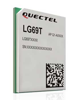
    The LG69T GNSS module is an automotive-grade dual-band high-precision GNSS module that integrates dead-reckoning (DR) and real-time kinematic (RTK) technologies. The module facilitates open-sky positioning performance with an accuracy of up to 10 centimeters. It supports next-generation precision positioning capabilities for smart vehicles and autonomous driving scenarios. The LG69T module is based on ST’s STA8100GA, the latest automotive-grade dual-frequency positioning chip with 80 tracking channels and four rapid-acquisition channels compatible with GPS, BeiDou, Galileo, Navic and QZSS. The AEC-Q100-qualified dual-band module integrates multi-band RTK technology for centimeter-level accuracy. The LG69T module’s dead-reckoning capabilities feature an integrated inertial measurement unit (IMU) that provides continuous high-precision positioning.

    Quectel Wireless Solutions, quectel.com

    STMicroelectronics, st.com
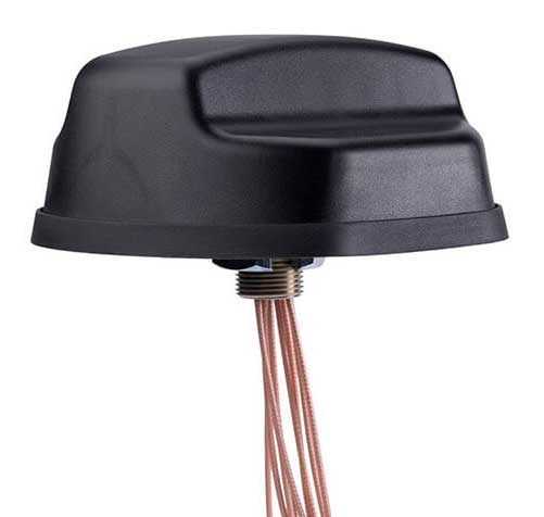
    Photo: PCTEL
    Photo: PCTEL

    Combo antenna

    For advanced rail communications

    The Coach II antenna with GNSS L1/L2/L5 is designed to provide greater precision and reliability for advanced rail communications systems, enabling next-generation positive train control (PTC) and passenger Wi-Fi. The Coach II features global multi-GNSS compatibility, dual-port 4G LTE / sub-6 GHz 5G NR and 802.11ac Wi-Fi / Bluetooth connectivity. It is AAR compliant for railway applications and is IP67-rated.

    PCTEL, www.pctel.com

    Firmware update

    Includes new automotive package for Ellipse GNSS/IMU products

    Photo: SBG Systems
    Photo: SBG Systems

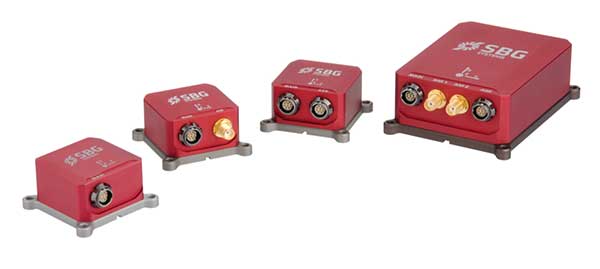
    New features have been added to the Ellipse product line with firmware update version 1.7. The update better answers needs of the autonomous testing and driving markets such as a CAN odometer. Users now have the choice to connect an external odometer (DMI) with pulses or use their car odometer with velocity information. New outputs include body velocity and slip angle, which calculate the drift angle between the vehicle’s assumed trajectory and its actual trajectory. For precision applications as well as low dynamics and reduced warm-up time, the new firmware allows users to run the Ellipse Kalman filter with no lever-arm estimation. This will ensure centimeter pass-to-pass accuracy for real-time kinematic (RTK) applications and allow operation in lower dynamics while reducing warm-up time. The firmware update also provides new features for advanced marine applications.

    SBG Systems, www.sbg-systems.com

  • FAA grants CMC Electronics approval for ADS-B Out compliance solutions

    FAA grants CMC Electronics approval for ADS-B Out compliance solutions

    The U.S. Federal Aviation Administration (FAA) has approved two Supplemental Type Certificates (STCs) for CMC Electronics, to help airplanes comply with automatic dependent surveillance-broadcast out (ADS-B Out) requirements.

    Boeing 737 Next-Generation Aircraft

    CMA-5024. (Photo: CMC Electronics)
    CMA-5024. (Photo: CMC Electronics)

    The FAA has approved an STC to install the SBAS-capable CMA-5024 GPS on Boeing 737 Next-Generation aircraft to comply with worldwide ADS-B Out mandates as well as SBAS/GPS navigation enabling the first localizer performance with vertical guidance (LPV) approaches for B737NGs.

    CMC’s solution, developed in collaboration with the FAA’s Navigation Programs office, offers operators the advantage of a cost-effective alternative to replacing their current multi-mode receiver (MMR).

    The CMA-5024 is an approved DO-260B ADS-B Out positioning source that may be paired with any DO-260B compliant transponder, allowing operators to meet FAA and EASA ADS-B Out requirements, the UAE’s ADS-B Out and RNP requirements mandated by GCAA as well as India’s GAGAN requirements.

    The CMA-5024 is the only solution available that is approved to introduce LPV on B737NG aircraft. With the CMA-5024, the B737NG aircraft can take advantage of satellite-based augmentation system (SBAS) navigation throughout all phases of flight.

    An LPV approach is the highest precision GPS instrument approach available not requiring specialized crew training. It aims to reduce costs associated with flight delays or cancellations and provides airlines with a safe approach into airports when ILS is unavailable.

    The CMA-5024 meets the requirements for an IFR civil certified GNSS and is compatible with all SBAS systems operating around the world such as WAAS, EGNOS, GAGAN and MSAS. SBAS augments GPS to provide an extremely accurate navigation solution throughout all phases of flight, from departure to en-route, through LPV CAT-l equivalent approach. The CMA-5024 complies with published Communication Navigation Surveillance/Air Traffic Management (CNS/ATM) navigational mandates.

    EASA approval of the STC is in progress. Future growth to GBAS GLS precision approach capability can be obtained by upgrading to CMC’s new CMA-6024 GPS/SBAS/GBAS receiver system.

    For Business Jets

    CMC Electronics and DAC International received an FAA STC (ST00934DE) for aircraft equipped with Honeywell’s Primus II avionics suite.

    The new STC provides a low-cost alternative to upgrading the existing onboard Honeywell equipment while meeting the DO-260B ADS-B Out worldwide mandate. This is achieved by replacing the existing non-compliant Primus II transponder with the Becker BXT6553 Diversity Transponder, paired with CMC Electronics’ CMA-3024 GPS/SBAS (GNSSU) receiver.

    The STC extends the operating life of a broad range of aircraft such as Bombardier’s Challenger 600 series, Hawker 800/800XP, Learjet 45, Gulfstream G-IV and GIV-X, Cessna Citation II and V, and many more.

    This is the latest addition to already existing STCs (ST03424CH and ST04159CH), which pair CMC’s CMA-3024 with the Rockwell Collins TDR-94/94D or Honeywell RCZ-8XX Primus II Com/Transponder to meet the DO-260B ADS-B Out standards mandated by the UAE’s GCAA, FAA and EASA for 2020.

    Claude Chidiac, Vice President, Sales and Marketing, at CMC Electronics said: “These STCs bring together the best that CMC and DAC have to offer to economically support business jet operators. They combine the respective technological strengths of both companies, namely the most advanced GPS receiver with DAC’s worldwide distribution channels and FAA approved kits. Our joint ADS-B Out solutions deliver high integrity and the cost-effectiveness that business aviation has been waiting for.”

    The CMA-3024 aviation sensor provides fully ADS-B compliant SBAS/GPS primary means navigation for business, regional, commercial air transport and helicopter aircraft. It is fully compatible and operational with all SBAS signals worldwide.

    With SBAS coverage, differential corrections are incorporated to further improve RNP capability, providing RNP0.1 with outstanding navigation system availability.

    Full installation kits, including the CMA-3024 and STC package, are provided by DAC International.

  • New Trimble R12 receiver boosts surveying performance

    New Trimble R12 receiver boosts surveying performance

    Photo: Trimble
    Photo: Trimble

    Trimble has introduced the the R12 GNSS receiver, a high-performance GNSS surveying solution. Powered by a new real-time kinematic (RTK) and Trimble RTX positioning engine, it features Trimble ProPoint GNSS technology that empowers land surveyors to quickly measure more points in more places than previously.

    Surveyors who work in challenging GNSS environments can use the Trimble R12 receiver to help reduce both the time in the field and the need for conventional techniques such as using a total station.

    The new Trimble ProPoint GNSS technology allows for flexible signal management, which helps mitigate the effects of signal degradation and provides a GNSS constellation-agnostic operation.

    In head-to-head testing with the Trimble R10-2 in challenging GNSS environments such as near and among trees and built environments, the Trimble R12 receiver performed more than 30 percent better across a variety of factors, including time to achieve survey precision levels, position accuracy and measurement reliability.

    “As a leader in the field of GNSS technology and innovation, Trimble dedicated many years of intensive research into developing the Trimble R12,” said Ronald Bisio, senior vice president of Trimble Geospatial. “This has culminated in a first-class solution, which enables our users to extend the reach of their systems to places where other RTK GNSS systems experience degraded performance.”

  • Epson offers SureColor T3170x compact printer

    Photo: Epson
    Photo: Epson

    Epson has launched the Epson SureColor T3170x 24-inch wide-format wireless printer. Engineered to enhance workflow, the new model in the SureColor T-Series product line offers cartridge-free printing in a clean, space-saving design.

    The new, easy-to-fill, refillable ink tanks eliminate time spent purchasing and changing ink cartridges. Ideal for low-cost POP and education posters, as well as blueprints and line drawings up to 24 inches, the SureColor T3170x produces accurate, A1/D-size prints in 34 seconds.

    “This SureColor T3170x joins the popular T-Series line that delivers powerful printing solutions for many industries, including architecture, engineering, construction, creative professionals and graphic design,” said Matt Kochanowski, product manager, professional imaging, Epson America. “The new refillable ink tank design provides greater flexibility and productivity for workgroups — taking away the worry of changing ink cartridges and lowering running costs — while also delivering the advanced features and space-saving design our customers expect.”

    The SureColor T3170x leverages an Epson PrecisionCore MicroTFP printhead with Precision Droplet Control to produce output with crisp lines and outstanding clarity. Whether printing from a roll or the Auto Sheet Feeder, the 4.3-inch color LCD touchscreen makes tasks simple and intuitive, and integrated wireless and Wi-Fi Direct connectivity, allows users to easily print from virtually anywhere in the office using a tablet or smartphone.

    Additional product features include:

    • Cartridge-free printing – High-capacity ink bottles with auto-stop for easy, mess-free filling
    • Ultra-fast print speeds – A1/D-size prints in as fast as 34 seconds
    • Low running costs – Ink included in the box can print a substantial number of posters or technical drawings
    • Easy to operate – Large, intuitive 4.3-inch color LCD screen simplifies print tasks
    • Compact, clean design – Ultra-small footprint,4 and sleek, minimal design enhances workspaces; easily fits on a desktop or on its own with optional stand, sold separately
    • Print from virtually anywhere in the office – Easily print from tablets, smartphones and more with integrated wireless plus router-free Wi-Fi Direct printing
    • Outstanding image quality – PrecisionCore MicroTFP printhead with Precision Droplet Control for outstanding clarity, plus commercial-grade reliability with Nozzle Verification Technology
    • Versatile media handling – Accommodates rolls up to 24-inch wide and sheets up to 11”x17” through the auto sheet feeder
    • Precise, sharp details – Print posters, blueprints, line drawings, and more up to 2400 dpi
    • Easy setup – Get up and running out of the box in as quickly as 30 minutes

    Availability

    The SureColor T3170x 24-inch wireless printer will be available through authorized Epson Professional Imaging resellers in December 2019. The SureColor T3170x offers a standard Epson PreferredSM Limited Warranty, a one-year program that includes toll-free advanced telephone access Monday through Friday. The Epson SureColor T3170x is designed to work exclusively with Epson ink. For additional information, visit www.proimaging.epson.com.

  • MicroSurvey CAD 2020 released

    MicroSurvey CAD 2020 released

    Photo: MicroSurvey
    Photo: MicroSurvey

    MicroSurvey has released MicroSurvey CAD 2020. MicroSurvey CAD is powered by the latest IntelliCAD 9.2 engine, providing users with unencumbered survey drafting and calculation workflows, including COGO, point tools for gridline-based projects, traverse input and adjustment, misclosure reporting, common data collector support, 3D surface representation and computation, corridor design, point cloud management and more.

    MicroSurvey CAD is perpetually licensed and is powered by IntelliCAD, which is compatible with AutoCAD drawing files. With five available feature levels — Basic, Standard, Premium, Ultimate and Studio — MicroSurvey CAD gives users the choice between several tiers of features to ensure they are getting precisely the tools and price point they need.

    Notable improvements in MicroSurvey CAD 2020 include:

    • IntelliCAD 9.2 which includes full support for AutoCAD 2018-2020 .dwg files, performance enhancements, new BIM tools, a block editor, start page, drawing cleanup tools, selection cycling, digital signatures, and much more;
    • Arc Labels have been drastically improved to utilize ArcAlignedText objects, which can be slid along an arc or polyline arc, in/out from the radius point, flipped upside down, and detected in the Lot Closure routine. Text on Arc also utilizes the ArcAlignedText objects to be editable as a single entity;
    • Upgraded CSMap Library includes over 125 new coordinate systems for Africa, Asia, Europe, Australasia and the U.S.

    Details are available in the MicroSurvey CAD 2020 Release Notes.

  • Eos releases underground infrastructure mapping solution for Collector for ArcGIS

    Eos releases underground infrastructure mapping solution for Collector for ArcGIS

    Eos Locate for Collector for ArcGIS enables utilities to map buried assets with submeter or centimeter accuracy

    A worker using an Arrow receiver and vLoc from Vivax Metrotech. (Photo: Eos Positioning)
    A worker using an Arrow receiver and vLoc from Vivax Metrotech. (Photo: Eos Positioning)

    Eos Positioning Systems Inc.  (Eos) has released its underground utility asset-mapping solution: Eos Locate for Collector for ArcGIS.

    Eos Locate for Collector combines three core technologies: Eos Arrow GNSS receivers, Esri Collector, and the Vivax-Metrotech vLoc Series of locator devices.

    With Eos Locate for Collector, one field worker can collect both GNSS locations and locator data (such as depth below cover) for any buried asset including water, sewer, electric, cable, gas, fiber infrastructure and more. They can do so quickly, accurately and without the need for any additional field or office support.

    “We are giving our Arrow GNSS customers a solution today that allows them to combine both locator data and high-accuracy locations in web maps,” Eos CTO Jean-Yves Lauture said. “This greatly simplifies their workflow by allowing one person to do underground locates and GIS mapping simultaneously.”

    “This is a big step forward for utility organizations who need to gain better visibility of their infrastructure,” said Doug Morgenthaler, Esri program manager. “With today’s technology, utilities can already see where new assets are being put in the ground. The challenge historically has been figuring out where existing assets are.”

    Eos Locate for Collector not only streamlines underground-asset mapping, but also improves office production times. It eliminates the need to manually combine datasets from the locator and GPS devices within ArcGIS.

    “Seeing all that information from utility locators and GPS receivers packaged directly into a GIS application is exceptional,” Vivax-Metrotech Eastern Regional Sales Manager Kelvin Cherrington said. “This solution will help utilities create maps of their underground assets with a much more modern and efficient methodology.”

    Indiana American Water Early Adoption

    Earlier this year, Indiana American Water approached Eos to seek a solution that consolidated their utility-locate workflow with their Arrow and Collector field work.

    “We had the manpower to put paint down,” said Todd Chapman, Indiana American Water Senior GIS Analyst. “But we would need to hire another person to map the locations with our Arrow Gold GNSS receivers.”

    Chapman estimates Eos Locate for Collector will cut their field time in half as well as enable the creation of extremely accurate buried-infrastructure maps in ArcGIS.

    “Previously, we were seeing that our old water mains could be off by up to 20 feet,” Chapman said. “With the new Eos Locate for Collector, we’re seeing that it’s accurate to under an inch.”

    The initial release of Eos Locate for Collector runs on Apple’s iOS iPhones and iPads and supports the vLoc Series from Vivax Metrotech. Future releases of Eos Locate for Collector will support additional locator models including the vScan series.

    With accurate digital twins of their buried infrastructure, utilities across sectors can expect improvements to safety, damage prevention, field efficiency and regulatory compliance.

    “Not only does this mean quicker responses to 811 tickets and fewer liabilities during field digs,” Lauture said. “But it also constitutes a major step forward toward the highly efficient future of 3D asset management and viable augmented-reality workflows.”

  • SkyBitz GPS tracker targeted at light- to medium-duty trucks

    SkyBitz GPS tracker targeted at light- to medium-duty trucks

    SA2012 offers customers configurable GPS tracking device on the latest 4G network

    Photo: SkyBitz
    Photo: SkyBitz

    SkyBitz has launched the SA2012, equipped with the latest 4G LTE with 3G fallback, positioned for the light- to medium-duty vehicle tracking market.

    With the option to purchase a range of price packages with configurable feature sets, the SA2012 is designed for customers looking for a scalable vehicle telematics solution they can use to increase profit margins and satisfy customer demand.

    The hardware can be installed using the Ops Center mobile device, either directly plugging it into the vehicle diagnostic port or covertly installing it behind the dashboard, depending on customer preference.

    Once installed, the device feeds into the SkyBitz Ops Center platform, where users can manage the new device alongside all others via a single interface. Customers will have coverage across North America, including Mexico and Canada.

    The basic package includes GPS location data and estimated odometer and engine hours. With several options leading up to the Pro package, SkyBitz offers a variety of location, engine, and safety data that can be selected based on the customers’ operational goals and budget.

    Customers can configure their solution with minimal training, adding features such as advanced alarms and notification schedules and over-the-air upgrades when future features are released.

    “SkyBitz strives to bring the latest technology to market that meets industry demand but also exceeds our customers’ expectations. This is one more device added to the SkyBitz product line that is now delivered on the latest network, and integrated into the SkyBitz Ops Center platform so customers can easily see vehicle and asset data on one dashboard,” said Debbie Sackman, senior product manager with SkyBitz. “This device targets small and medium businesses and offers a flexible package choice where customers can add additional features with OTA upgrades as their business grows.”

  • Geneq launches SXPad 1500 rugged data collector

    Geneq launches SXPad 1500 rugged data collector

    The New Handheld Is Designed for Data Collection for Land Surveying and Geospatial Information Systems (GIS)

    Photo: Geneq
    Photo: Geneq

    Geneq Inc. has added a new data collector to its SXPad product line. The rugged SXPad 1500 data collector features a full alphanumeric QWERTY keypad and long-range Bluetooth, and was designed to meet the rigorous IP67 standard to deal with challenging field conditions.

    The SXPad 1500 and its 5-inch sunlight-readable touchscreen can be connected to any GNSS receiver or compatible robotic total station to ensure the success of all survey projects.

    Driven by a 1-GHz processor and the Windows Mobile 6.5 operating system, the field collector is a high-performance device designed to provide the power needed to work with maps and large data sets in the field, as well as many software solutions.

    With its integrated cellular modem and Wi-Fi standard, the SXPad 1500 offers wireless connectivity for internet access and GIS data transfer. This feature will be helpful for setting parameters and configuring the SXblue PREMIER and F90 or any real-time kinematic (RTK)-compatible GNSS receiver.

    The SXPad 1500 has a GNSS internal module that delivers adequate performance for certain GIS field data collections.

    Equipped with an internal memory of 1 GB (memory can be expanded to 16 GB with an SD card), the SXPad 1500 provides enough storage space for data recording. Users will benefit from its high-performance lithium battery allowing uninterrupted field operation for up to 8 hours.

  • Launchpad: GOOSE receiver, splitter and decoder

    Launchpad: GOOSE receiver, splitter and decoder

    A roundup of recent products in the GNSS and inertial positioning industry from the October 2019 issue of GPS World magazine.


    OEM

    Multi-GNSS receiver

    Refined in the Galileo Online project for rail applications

    Photo: TeleOrbit
    Photo: TeleOrbit

    The multi-GNSS receiver GOOSE, distributed by TeleOrbit GmbH and developed by Fraunhofer IIS, is now available in a new housing. GOOSE now also includes the new OS-NMA beta standard, available by the end of 2019, which was integrated within the research project PRoPART. GOOSE is a flexible, professional GNSS receiver development platform with an open software interface, which can be adapted to a variety of applications and application-specific correction services. The flexible development platform offers multi-system and multi-signal real-time processing; integrated antenna receiver combination (smart antenna); guaranteed stable phase center for all GNSS frequencies; and deployment in commercial PC or as an embedded platform. It allows deep coupling and vector tracking in real time; access to correlation values; and record and replay of IF samples. It also offers access to SBAS data including upcoming augmentation systems and differential augmentation systems. The platform has been refined in the Galileo Online project for specific usage in rail applications. It has also been further upgraded as a robust and reliable Galileo position sensor for autonomous truck applications.

    TeleOrbit, teleorbit.eu

    Inertial measurement

    Low-noise performance for high dynamic applications

    Photo: Gladiator Technologies
    Photo: Gladiator Technologies

    The LandMark 007 inertial measurement unit (IMU) combines low noise, high range sensors and Velox high-speed output in a rugged package measuring 0.7 inches square. With rate ranges up to 2000°/s and acceleration ranges as high as 200 g, the LandMark 007 IMU provides demanding, precision performance for a range of high dynamic, rugged applications. High-speed output data rates (up to 10 kHz) for measurement accuracy and flexibility are complemented by low-noise gyros and accelerometers. A development kit is available.

    Gladiator Technologies, gladiatortechnologies.com

    Decoder

    Corrections data from L6D and l6E

    How Allystar's QZSS L6 Decoder TAU1303 operates. (Diagram: Allystar)
    Diagram: Allystar

    The QZSS L6 decoder module TAU-1303 supports tracking QZSS signals L6D (CLAS) and L6E (MADOCA). It can decode corrections data broadcast from L6D and L6E signals, and assist developers in applying the centimeter-level accuracy by PPP-RTK algorithm with the correction data. Within its 7.6 × 7.6-millimeter size, the module provides six channels to support tracking L6D and L6E at the same time. CLAS on L6D channel corrects satellite clock, orbit, code bias, phase bias ionosphere delay and tropospheric delay. MADOCA on L6E channel corrects satellite clock, orbit, code bias and phase bias. The TAU-1303 offers superior performance through an on-board 26-MHz temperature-compensated crystal oscillator (TCXO) and a reduced time to first fix because of its dedicated 32-KHz real-time clock oscillator. Based on 40-nanometer manufacturing processes of the Cynosure III GNSS chipset, the TAU-1303 has very low power consumption of less than 40 mA at 3.3V.

    Allystar Technology Co., www.allystar.com

    GPS Splitter

    Uses only one rack space

    Photo: ViaLite
    Photo: ViaLite

    ViaLite’s new Local Integrated GPS Splitter was designed to minimize rack space. The unit provides a fan-out of GPS/GNSS signals within a local area, can accept optical inputs from up to four antennas, and has a 1000-1800-MHz frequency range. Though it has a height of only one rack unit, the system is useful for feeding timing and synchronization signals to single or multiple floors or rooms through eight to 32 optical fiber links with no system loss. It includes built-in simple network management protocol (SNMP) control as well as dual-redundant power supply units. Built for data centers, banking institutions, scientific research establishments, cellular test environments, fixed satcom stations, oil and gas platforms, and big data.

    ViaLite, vialite.com


    SURVEYING & MAPPING

    Point-cloud software

    Creates intelligent 3D mesh models

    Image: Pointfuse
    Image: Pointfuse

    Pointfuse point-cloud processing software converts the millions of individual measurements captured by laser scanning and photogrammetry into 3D mesh models.The latest release features streamlined classification to ensure maximum efficiency and multicore processing for unlimited conversion power. The ability to classify objects and compare as-built objects with the design enables more accurate clash detection, reducing the number of false clashes being flagged. Intelligently optimized mesh models reduce the working data size by a factor of up to 100, making them easy to share with online 3D collaboration platforms, such as BIM 360, 3D Repo, Revitzo and Trimble Connect.

    Pointfuse, pointfuse.com

    Android Software

    Mobile data collection in the field

    FieldGenius for Android, v1. (Image: Hexagon)
    FieldGenius for Android, v1. (Image: Hexagon)

    FieldGenius for Android, version 1.0, is multi-platform data-collection software built on Android OS. The brand-neutral data-collection software supports most popular GNSS sensors on the market. Features include dynamic data panels synchronized with map views, intuitive interface, simplified workflows and readily available data that surveyors require to make informed decisions in the field. Early adopters receive additional benefits and participate in the newly created MicroSurvey Technology Innovation Group.

    MicroSurvey Software, microsurvey.com

    Handheld GNSS receiver

    Camera-enabled centimeter logging

    Photo: Spectra Geospatial
    Photo: Spectra Geospatial

    The SP20 handheld GNSS receiver offers innovative camera-enabled centimeter-accurate logging in an everyday GIS and survey tool. Rugged, lightweight and versatile, the SP20 delivers high-end performance. It is an easy-to-use tool that delivers accuracy from meter to centimeter, depending on the job. Android-based, it is useful for cadastral, construction or topographic surveys; a range of GIS jobs from data collection to inspection and maintenance; and non-traditional geospatial professionals. The 5.3-inch screen displays the new workflow using a camera to ensure 2D centimeter accuracy handheld and 3D centimeter accuracy with monopole setup.

    Spectra Geospatial, spectrageospatial.com

    Offline data transfer

    Alternative to the clouds

    Photo: Trimble
    Photo: Trimble

    TerraFlex users can now synchronize data directly to their on-premise Esri geographic information system without cloud services. The new software workflow — called offline data transfer — is possible through the integration of Trimble TerraFlex and the Trimble Positions Desktop add-in for Esri ArcGIS Desktop. TerraFlex is a field solution that enables mobile workers to easily collect, manage and edit their geospatial feature data. The new workflow provides an alternative to using Trimble cloud services for storing and transferring GIS feature data collected with the TerraFlex platform. In addition, TerraFlex field data collected via this workflow using a Trimble GNSS receiver can be post-processed directly inside the Trimble Positions Desktop add-in for improved positional accuracy. The mobile apps are available in Apple’s App Store and the Google Play store.The Trimble Positions Desktop add-in is available through the Trimble Geospatial distribution channel.

    Trimble, www.trimble.com

    GPS Receiver

    Now compatible with iPhone and iPad 

    Photo: Juniper Systems
    Photo: Juniper Systems

    The Geode GNS2 sub-meter GPS receiver features connectivity with a range of iPhone and iPad devices, made possible by the Geode’s new MFi certification. Features of the Geode GNS2 include an IP-68 rating to withstand harsh environments, all-day battery life, multiple correction sources for precise real-time data, and an open interface that works with a wide range of Windows, Android, iPhone, and iPad devices as well as Juniper Systems’ handhelds.

    Juniper Systems, junipersys.com 

  • MicaSense offers Altum 3-in-1 sensor for ag drone mapping

    MicaSense offers Altum 3-in-1 sensor for ag drone mapping

    The Altum is a 3-in-1 sensor that combines thermal, high-resolution and multispectral imaging capabilities in one sensor. (Photo: MicaSense)
    The Altum is a 3-in-1 sensor that combines thermal, high-resolution and multispectral imaging capabilities. (Photo: MicaSense)

    The Altum sensor, offered by MicaSense, is designed for professional-grade agricultural drone mapping by enterprise and academic researchers. The Altum captures synchronized multispectral and thermal imagery, enabling aligned outputs for advanced analytics.

    Altum’s multispectral imagers are the highest resolution integrated multispectral solution available for drones, allowing for detailed RGB outputs and advanced crop classifications.

    Whereas before they had to fly multiple flights with multiple sensors, researchers, growers and service providers can now capture data for plant health, water stress mapping, phenotyping and more in one flight, with one sensor.

    The Microsense RedEdge-MX sensor aboard DJI's M210 RTK drone. (Photo: MicaSense)
    The Microsense RedEdge-MX sensor aboard DJI’s M210 RTK drone. (Photo: MicaSense)

    “The Altum design resulted from experience developing advanced analytics and understanding needs for advanced research,” said Justin McAllister, CTO and co-founder of MicaSense. “We realized the market is limited by time and cost constraints of owning multiple sensors and flying multiple passes over the same field. The goal of Altum is to simplify the workflow, and with synchronized capture, to provide results that can be correlated and quantified more easily.”

    Altum includes MicaSense’s standard five-band configuration of multispectral bands (red, green, blue, near-infrared and red-edge) and an integrated Lepton radiometric thermal longwave infrared sensor from FLIR Systems, providing temperature measurement for every pixel of the scene for additional crop data and optimization.

    https://youtu.be/Kdim4uol7S4

    Expandable high-capacity USB 3.0 storage allows users to fly longer and cover more area without landing to swap storage. In addition, advancements in image capture rate enables faster flight speeds.

    Users can process Altum data with industry standard software like Agisoft and Pix4Dmapper to generate an aligned, radiometrically calibrated six band (R, G, B, RE, NIR, T) geotiff, or access the raw data from Altum to process data themselves.

    Included with Altum is DLS 2, the patent-pending next generation of the MicaSense Downwelling Light Sensor (DLS). DLS 2 allows for a more streamlined integration as it combines both the DLS and GPS into one product. In addition, through proprietary MicaSense technology, the DLS 2 will offer significantly better calibration for changing light conditions and better measurements over time.

    Integrated solutions

    Altum’s multiple interface options and open API gives users the ability to utilize Altum on a variety of platforms. In addition to the DJI SkyPort integration, Altum is integrated with drone offerings from the following companies (with more to come):

    • North America: Drone Nerds (U.S.), BirdsEyeView Aerobotics (U.S)., OmniView Tech (Canada), Sky Flight Robotics (U.S.), Blue Skies Drone Rental (U.S.)
    • Europe: 3D Target (IT), Globe Flight (DE), C-Astral (SI), Droneparts.de (DE), Ecobotix (DK), NaviGate (PL), Quantum Systems (DE)
    • Asia: Cybernetech (Japan), Shenzhen Qianhai Yaqi Technology (China)

    DJI Payload SDK Program: Altum and RedEdge-MX for DJI M200 Series

    Through DJI SkyPort, MicaSense is able to provide seamless integration of its specialized sensors with DJI’s powerful line of enterprise drones, resulting in the MicaSense Altum and RedEdge-MX solutions. This provides users a high-quality drone and sensor combination they can rely on to capture quality data every time – with virtually no set-up time.

    The DJI SkyPort integration for Altum and RedEdge-MX features plug-and-play integration for Altum and RedEdge-MX right out of the box, including power and quick connect/disconnect, and enhanced light calibration with MicaSense DLS 2.

    “Solutions like the MicaSense Altum and RedEdge-MX demonstrate the value of integrating specialized industrial payloads to DJI’s powerful drone platforms,” said Jan Gasparic, head of Enterprise Partnerships at DJI. “By collaborating with solution providers, we are expanding the benefits of drone technology to more and more industries. In the case of agriculture, a specialized suite of sensors and more advanced level of analytics can truly bring tangible value to business workflows and decision making today.”

    The Altum and SkyPort enabled RedEdge-MX and Altum are available today through the MicaSense website.

  • Riegl launches lightweight airborne lidar for UAVs

    Riegl launches lightweight airborne lidar for UAVs

    The miniVUX-2UAV airborne laser scanner. (Photo: Riegl)
    The miniVUX-2UAV airborne laser scanner. (Photo: Riegl)

    The Riegl miniVUX-2UAV is a lightweight airborne laser scanner designed specifically for integration with unmanned aerial vehicles and systems.

    Riegl added the new miniaturized UAV sensor to its portfolio of professional solutions for UAV-based surveying.

    The sister type of the miniVUX-1UAV sensor, the miniVUX-2UAV offers 100 kHz and 200 kHz PRR. With the 200-kHz PRR, the sensor provides up to 200,000 measurements per second, and thus a dense point pattern on the ground for UAV-based applications that require the acquisition of small objects.

    The Riegl miniVUX-2UAV makes use of Riegl waveform lidar technology, allowing echo digitization and online waveform processing. Multi-target resolution is the basis for penetrating dense foliage, and the wavelength is optimized for the measurement of snowy and icy terrain.

    In addition to the stand-alone version of the miniVUX-2UAV, Riegl also offers fully-integrated solutions.

  • Tallysman adds 3 more to Helical antenna line

    Tallysman adds 3 more to Helical antenna line

    Photo: Tallysman
    Photo: Tallysman

    Tallysman GNSS has added three new antennas to its Helical antenna line.

    Released earlier this year, the helical antenna line provides unprecedented performance in a lightweight, compact form factor.

    The line now extends beyond dual-band GNSS and Iridium support to also include single and triple GNSS frequency bands.

    Tallysman helical antennas are designed for applications that require high performance and versatility, with an absolute minimum of weight, such as unmanned aerial vehicles (UAVs).

    In addition to the HC600, HC871 and HC872, the expanded helical antenna family now includes:

    • the single frequency HC771
    • the dual- frequency (plus L- band corrections) HC882
    • the triple band (plus L- Band corrections) HC975.

    The table below lists the complete Tallysman helical Family of antennas.

    Chart: Tallysman
    Chart: Tallysman