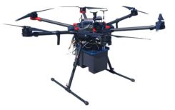
Terra Drone Corporation has launched a new UAV and artificial-intelligence (AI)-based solution designed for maintenance of power transmission and distribution equipment.
The solution was developed based on market gaps identified after inspecting more than 90,000 kilometers of power lines beyond visual line of site (BVLOS) throughout the world.
Acquired data is automatically processed and analyzed by artificial intelligence algorithms trained to detect crossovers at the bottom of transmission lines, buildings and construction machinery.
The system identifies rust on bolts, loosening and missing tower parts, bird’s nests and more. It then generates a smart report highlighting areas that require action. The error (identified anomaly) detection system is accurate up to 92.5%.
The algorithm for an area is developed through a process identifying anomalies in a training data set of 1,500 images. This allows for a custom solution to be created for the end client where all pertinent anomalies are identified and reported.
The development and training of the algorithm only need to be completed once for a particular type of asset and can be implemented easily at different locations on similar assets.
With such a high-precision algorithm, the productivity of AI processing allows for fast actionable results to be provided to clientele. Clients also have the ability to identify the appropriate security protocols for data storage in either a cloud-based or on-premises storage environment. These protocols can then be implemented in a custom client-specific solution.
Loosening and missing tower parts identified by high-accuracy detection system (Photo: Terra Drone)
Power transmission and distribution companies must conduct periodic inspections of power line infrastructure to ensure reliable electric power distribution, although the conventional methods of deploying ground staff or low-flying helicopters to complete the inspections, they are typically cost-prohibitive. Conventional helicopter and boots-on-the-ground service also pose HSE concerns with low flying helicopters and people working in the field. UAV service and AI inspection can aid in minimizing HSE concerns by reducing the number of workers in the field and eliminate low level manned helicopter missions.
This solution has been built from ground up with the aim to simplify and streamline the maintenance work for transmission and distribution facilities.
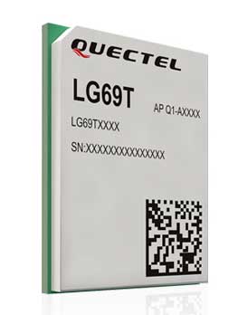
Quectel Wireless Solutions Co. Ltd., in association with STMicroelectronics, has released the LG69T module, an automotive-grade dual-band high-precision GNSS module that integrates dead-reckoning (DR) and real-time kinematic (RTK) technologies.
The new Quectel module, announced at 2019 Apsara Conference in Hangzhou, is designed to facilitate open-sky positioning performance with an accuracy of up to 10 centimeters, which is currently the industry’s most advanced positioning technology for the automotive market. LG69T will support next-generation precision positioning capabilities for smart vehicles and autonomous driving scenarios.
The Quectel LG69T GNSS module is based on ST’s STA8100GA, the latest Automotive-grade dual frequency positioning chip with 80 tracking channels and four rapid-acquisition channels that are compatible with many constellations: GPS, BeiDou, Galileo, NAVIC/IRNSS and QZSS.
It is an AEC-Q100-qualified dual-band (L1 + L5) GNSS module that integrates multi-band RTK technology for centimeter-level accuracy.
The LG69T module’s dead-reckoning capabilities feature an integrated inertial measurement unit (IMU) that provides continuous high-precision positioning. The LG69T supports corrections input for standard Radio Technical Commission for Maritime Services (RTCM) and centimeter-level navigation by using RTCM data from a third — local base stations. The module performs well under the highly challenging conditions of urban canyon environments.
“We are thrilled to collaborate with STMicroelectronics on our newest generation of high-precision positioning module,” said Min Wang, Quectel’s automotive product line general manager. “With this highly-integrated LG69T module, automakers and Tier 1 suppliers will no longer have to spend time selecting components, integrating hardware, adapting interfaces and conducting tests and verifications, which will greatly cut their time-to-market and costs, and help them accelerate the deployment of autonomous driving to seize early opportunities.”
“ST has strong experience and is the Global Automotive High Precise Positioning Technology and Market Leader. We are very proud to cooperate with leading Chinese smart driving high technology company,” said MH TEY, Greater China, South Asia and Korea automotive marketing and application head of department, STMicroelectronics. “Today, there is growing dependency on high-performance GNSS in automotive applications such as navigation, safety and autonomous driving. With this cooperation, we are very confident to become the market leader by providing cost-effective and unique best-in-class solution for autonomous vehicle.”
Engineering samples of Quectel’s LG69T module will be offered to automakers and Tier 1 suppliers by the end of 2019, and the product will be commercially available around mid-2020 and is expected to be deployed in mass produced models as early as 2021.
A roundup of recent products in the GNSS and inertial positioning industry from the September 2019 issue of GPS World magazine.
OEM
Vehicle tracker
Uses u-blox to detect panic breaking
Photo: u-blox
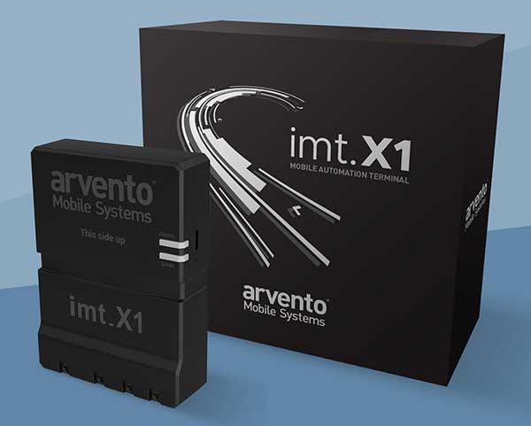
Arvento’s imt.x1 has a six-axis gyro sensor that can sense three-dimensional movement caused by emergency acceleration, panic braking and directional yaw and drift. With connectivity options including dual CANBus and Bluetooth, the system is eCall compatible and captures and provides data for accident analysis and other vehicle tracking functions. The system also uses the next-generation powerful Arm-based microcontroller. The system’s high position sensitivity and accuracy are based on integration of u-blox’s 2G, 4G and 5G-ready cellular modules as well as GNSS modules.
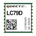
The compact LC79D module features concurrent multi-constellation GNSS receivers on dual GNSS bands. It uses L1 and L5 for GPS, Galileo and QZSS, L1 band for GLONASS and BeiDou, and L5 band for IRNSS. It can generally increase the number of visible satellites, significantly improve positioning drifting when driving in urban canyons and enhance positioning accuracy. Embedded with a low-noise amplifier (LNA) and multi-tone active interference, the module provides high sensitivity and reliable anti-jamming capability, ensuring exceptional acquisition and tracking even in weak signal areas.
The mosaic development kit helps integrate mosaic into an existing system. Mosaic is a compact high-precision multi-frequency GPS/GNSS module that brings precision and reliability of high-end multi-frequency GNSS to mass-market applications. Its light weight and low power consumption makes mosaic suitable for robotics, automation, telematics and wearables. The kit supports connectivity through internet, COM ports, USB 2.0 and an SD Card slot. Mosaic provides Advanced Interference Mitigation (AIM+); extensive corrections support for high-accuracy positioning; integrity needed for safety-critical applications such as autonomous vehicles; and a 100-Hz update rate, suitable for robotics and fast-moving vehicles.
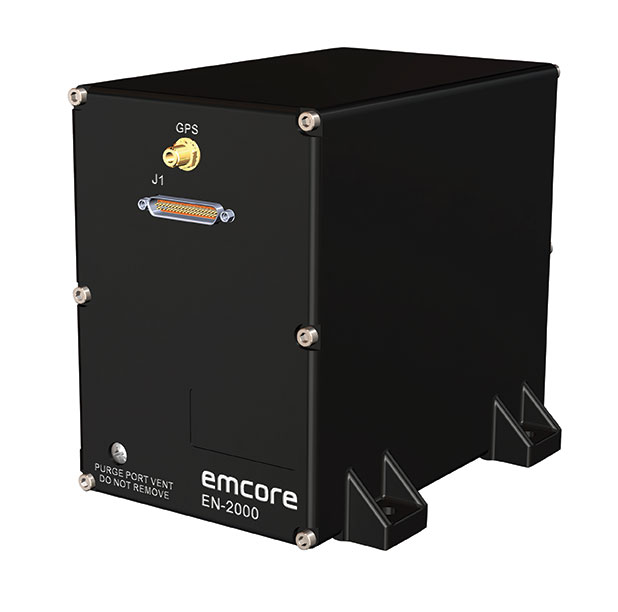
The EN-2000 is the newest addition to the Emcore-Orion series of micro-inertial navigation (MINAV) systems. It is compact and lightweight, weighing less than 7 pounds, with very low power consumption of 10 watts. It can deliver twice the performance of the EN-1000 with the same form factor. With its low size, weight and power (SWaP), the compact EN-2000 is suitable for unmanned aerial vehicles, unmanned underwater vehicles, unmanned ground vehicles, manned aircraft, rotorcraft and dismounted soldier applications. Its three-axis design uses a solid-state optical transceiver with advanced integrated optics, combined with new field programmable gate array (FPGA) electronics to deliver stand-alone aircraft-grade navigator performance at one-third the SWaP of legacy systems.
The Miniature PLGR Engine – M-Code (MPE-M) GPS receiver is a small Type II form factor ground receiver, and incorporates the company’s recently certified Common GPS Module (CGM). As a drop-in replacement for the thousands of customers using Collins’ Miniature PLGR Engine-SAASM (MPE-S) GPS receiver, the new MPE-M technology provides 10 times stronger anti-jamming capabilities for the direct acquisition of GPS signals than its predecessor. The MPE-M receives the current military Y-code GPS signal along M-code. It provides warfighters with improved security and assured positioning, and it satisfies the U.S. government’s requirement for all military GPS equipment to be M-code capable. It is designed for lightweight, ground-based applications such as radios, blue force trackers, targeting devices, vehicle line-replaceable units (LRUs) and small unmanned aircraft. The MPE-M’s security certification makes the receiver eligible for export to U.S. allies through the Foreign Military Sales (FMS) program.
The Catalyst software-defined GNSS receiver for Android phones and tablets is now available with a usage-based service plan: Trimble Catalyst On Demand. The new service plan meets the needs of industries and organizations that need a more flexible payment model. Organizations use Catalyst to record positions, navigate to points, measure relative distance and create digital maps. Trimble Catalyst On Demand provides scalable access to real-time kinematic (RTK)-quality GNSS positioning using a pay-per-use hourly pricing model in addition to the current Catalyst monthly plans. The service also enables automated domain-level email address access, which streamlines license allocation for organizations with a large number of users. (Pictured: Catalyst DA1 antenna).
The DT301X is designed for 3D mapping. Its Intel RealSense Depth camera provides real-time 3D imaging combined with a dual-frequency GNSS module for real-time mapping and positioning. The digital images are better than high-definition standard, and are suitable for construction building information management (BIM) graphics. The highly durable IP65 and MIL-STD-810G-rated tablet in a slim case can be used in the field, office and vehicles. A bright 10.1-inch touchscreen provides indoor/outdoor viewing. The tablet includes long-range Bluetooth and 4G LTE mobile broadband for the latest in high-speed communications. An Intel 8th-generation Core i5 or i7 processor offers high performance while still being energy efficient.
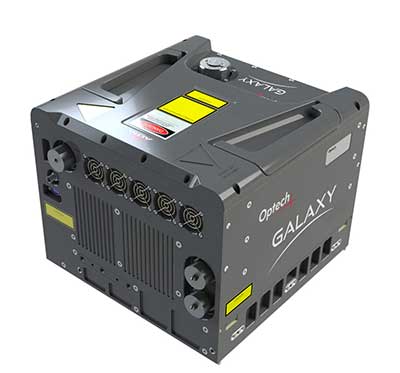
Mapper for wide-area, mountain, urban and corridor surveys
Photo: Teledyne Optech
The ALTM Galaxy PRIME wide-area lidar sensor offers collection efficiency, a small form factor and high-quality data sets that meet rigorous USGS lidar standards. It has a 6,000-meter above-ground-level (AGL) collection envelope and 1-MHz on-ground collection rate. Galaxy PRIME includes lidar technology enhancements to increase sensor performance and collection efficiency, improve data quality, and simplify the collection process. It can be used either gyro-stabilized or fixed-mounted, one camera or six, and full waveform or discrete. PulseTRAK technology enables a continuous operating envelope by eliminating data coverage gaps and irregular point density. Applications include wide-area mapping, urban mapping, natural resource management, engineering, infrastructure modeling, and powerline and transportation corridors.
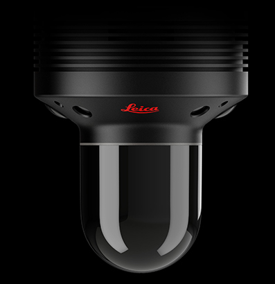
The Leica BLK247 real-time reality-capture device uses sensor fusion technology to detect and report physical changes within a space. It is designed for continuous 3D reality capture, extending capabilities for safety and security applications. The sensor provides real-time situational awareness through edge computing and lidar-enabled change-detection technology. Using artificial intelligence, the BLK247 can tell the difference between still and moving objects — such as a person walking who leaves a suitcase behind — and identify security threats to provide real-time alerts.
Version 15 of Grapher has new capabilities to improve the ability to model, analyze and interpret data as well as communicate the results. Grapher users can now access new Fit Curve, Axes and Statistical Plotting capabilities. Also, users are provided greater color customization functions in the latest release. Enhancements give Grapher users a more powerful ability to display and communicate the results of their work to others. The software provides 80 different 2D and 3D plot types for analyzing and displaying scientific data.
The Harris Aerial H4/H6 Hybrid multicopter is now offered as an integrated package with any Lidar USA scanning system. The Harris Hybrid can provide longer flights with lidar and industrial-grade cameras. The Harris Hybrids use a small generator running on 95 or higher octane fuel to power the UAV for up to five hours.The H6 can carry an A-series high-definition lidar system of 3 kg for 2.5 hours and a V-series of 5 kg up to 1.5 hours. For the lidar operator, this means most projects will require only one or two flights.
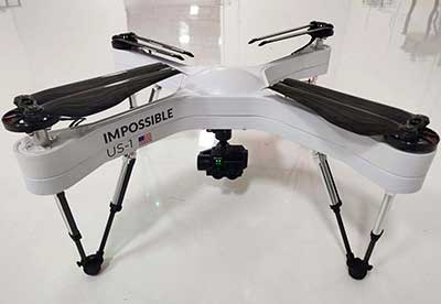
The US-1 was built with sensitive enterprise and government customers in mind. It was designed from the ground up in the United States with a battery-first approach to enable electric aircraft to compete with conventionally fueled incumbents. The US-1 runs on a secure open-source operating system by Auterion. It provides 78 minutes of flight time and high-resolution optical and thermal cameras. US-1 UAVs have been deployed to fight fires, locate pipeline leaks, and track armed suspects.
Impossible Aerospace, impossible.aero
The DRS-M600 reusable parachute safety solution, developed for DJI M600 and DJI M600 Pro, meets specifications of the ASTM F3322-18 standard. The successful completion of the ASTM standard test makes it possible for the Federal Aviation Administration to issue permits for its use on drones over crowds. The ASTM F3322-18 standard is the first standard for parachute systems designed specifically for small UAVs.
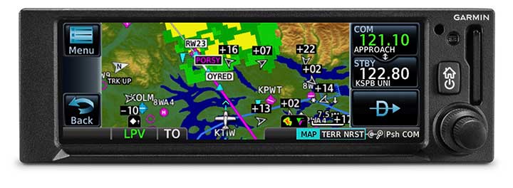
The GNC 355 is a GPS navigator with localizer performance with vertical (LPV) approach guidance. (Photo: Garmin)
The GNS 355 GPS navigator with localizer performance with vertical (LPV) approach guidance gives pilots the benefits of WAAS/SBAS GPS guidance with a modern communications radio. Intended for Class I/II aircraft that weigh 6,000 lbs./2,721 kg. or less, the GNC 355 is certified for more than 700 aircraft makes and models. Aircraft owners can incorporate the GNC 355 into an existing avionics stack because of its standard 6.25-inch wide by 2-inch tall design. The responsive touchscreen display allows pilots to quickly access direct-to functionality, moving map, flight plan, nearest, procedures, waypoint and terrain pages and create customizable data fields and shortcuts for quick, one-touch access to important information. Fully WAAS/SBAS IFR-approach-capable, the GNC 355 gives pilots the benefit of flying LPV, as well as Area Navigation (RNAV) approaches. Many approaches offer vertical approach guidance as low as 200-feet above ground level (AGL).
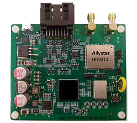
The Allystar INS Platform is a dual-antenna, multi-frequency, multi-GNSS inertial navigation system (INS) that delivers accurate and reliable position, velocity and orientation. It combines high-grade, six-axis, temperature-calibrated accelerometers and gyroscopes with a multi-frequency, multi-GNSS engine, the HD9300 series. The HD9300 is a dual-antenna chip-grade real-time kinematic (RTK) GNSS receiver for accurate positioning and heading. The Allystar INS platform contains an on-board sensor-fusion filter, plus navigation and calibration algorithms for different dynamic motions of land vehicles. The Allystar OBD Data Adapter (v1.0) enables users to read and monitor various sensors built into cars, obtaining real-time vehicle speed and gear signals from the on-board diagnostics (OBD) interface, and then output AT (attention) commands by serial port or serial peripheral interface (SPI).
EOS has partnered with four high-resolution imagery providers — Airbus Defense and Space, SI Imaging Services, SpaceWill and 21AT — so users can purchase the latest images directly from LandViewer, the official high-resolution data reseller, or view the images of an area of interest in high resolution on the map.
LandViewer collects the latest up-to-date satellite imagery from commercial satellite providers and incorporates it into an easy-to-use platform. The collection is constantly being improved with new sensors.
LandViewer offers two data sources of commercial imagery:
High-resolution imagery (for analytics), to find and purchase high-resolution images for further in-depth analysis. In this case, the price is based on the size of the area of intersection between the selected image and your area of interest (AOI).
Image from Landviewer for analytics. (Image: EOS)
High-resolution imagery (view only) to view high-resolution images for your area of interest (AOI). In this case, the price is based on the number of tiles within your AOI. The view only option is designed as a stand-alone data source for the everyday business user.
Image from Landviewer (view only). (Image: EOS)
The EOS platform uses commercial imagery from LandViewer with a resolution between 0.3 meter and 1.5 meters, enabling a close look at assets of interest, anywhere in the world.
ViaLite’s new Local Integrated GPS Splitter was designed to minimize rack space. Suitable to applications requiring a fan-out of GPS/GNSS signals within a single local area, the unit can accept optical inputs from up to four antennas.
Though it has a height of only one rack unit, the system is suitable for feeding timing and synchronization signals to single or multiple floors or rooms through 8 to 32 optical fiber links with no system loss.
Available with 1×8, 2×8, 4×8, 1×16 and 2×16 options, the easy-to-install GPS Splitter has a 1000-1800-MHz frequency range. Built-in simple network management protocol (SNMP) control is included as well as dual-redundant power supply units.
Typical application areas include data centers, banking institutions, scientific research establishments, cellular test environments, fixed satcom Earth stations and teleports, oil and gas platforms, and big data.
“Our new GPS Splitter was developed in response to customer demand across a wide range of sectors,” said ViaLite Product Manager John Golding. “We are pleased to have been able to meet their needs by providing a very high-quality product at a reasonable cost.”
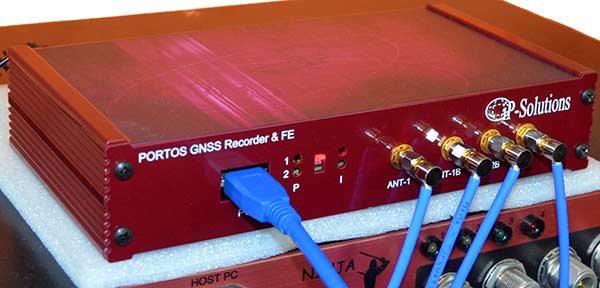
Portos Team paired with the Ninja. (Photo: iP-Solutions)
Japan-based iP-Solutions has introduced Portos Team, a new GNSS RF signal record-and-playback system.
The Portos Team can record and play back — or simulate —multi-frequency, multi-system GNSS signals when paired with the company’s Replicator. It can do the same for CRPA signals when paired with the Ninja (see photo).
The Portos itself can also operate as multi-frequency or CRPA front-end for a GNSS software receiver.
The high-end Ninja simulator allows for multi-antenna controlled radiation pattern antenna (CRPA) and local-area augmentation system (LAAS) simulation, the company said.
The 24-channel Replicator — developed in collaboration with the Japan Aerospace Exploration Agency (JAXA) — provides real-time generation of GNSS signals, recording and playback of dual-frequency GNSS RF signals, and GNSS RF signal analysis with JAXA COSMODE ionospheric scintillation monitor.
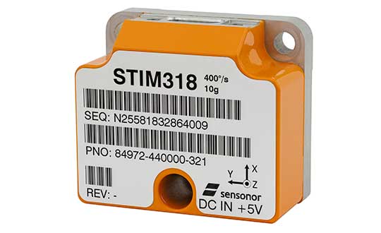
The new high-accuracy tactical-grade STIM318 inertial measurement unit (IMU) from Sensonor provides greatly increased accelerometer performance to support demanding guidance and navigation applications, the company said. Its performance can in many applications competitively replace fiber-optic gyros (FOGs).
Offering improved system performance with respect to robustness, reliability, size, weight, power and cost, it is designed for use in autonomous machine control, UAV payloads, satellites, portable target acquisition systems, land navigations systems, turret stabilization, missile stability and navigation, and mortar aiming systems.
STIM318 is comprised of three highly accurate MEMS gyros, three high-stability accelerometers and three inclinometers. Its development took place in close cooperation with a global customer developing autonomous machine control for accurate contour guidance. The IMU is built on the established STIM design that is field proven in commercial and military applications.
An ITAR-free product, STIM318 is available in export controlled and non-export controlled versions. It is compatible with Sensonor’s STIM300 IMU, and can bring additional capability to applications already using STIM300. STIM318 is available from stock.
In addition to the performance increase, STIM318 comes with a new Bias Trim Offset (BTO) function. This allows the user to individually zero out any bias of all 9 axes. The bias offset can be stored in flash, and then recalled at next system startup.
Higher rate, higher acceleration applications benefit from SWaP-C advantages of MEMS-based inertial systems.
Gladiator Technologies’ LandMark 007 inertial measurement unit (IMU) combines low noise, high range sensors and Velox high-speed output in a rugged IMU package measuring 0.7 inches square. With rate ranges up to 2000°/s and acceleration ranges as high as 200 g, the LandMark 007 IMU provides demanding, precision performance for a range of high dynamic, rugged applications.
Photo: Gladiator Technologies
All LandMark 007 IMUs feature Velox high-speed message timing to minimize digital message phase lag. They also include high-speed output data rates (up to 10 kHz) for measurement accuracy and flexibility.
These high-speed features are complemented by low-noise gyros with a gyro angle random walk (ARW) of <0.0035°/s/√Hz (0.15°/√hr) and low-noise accelerometers with a velocity random walk (VRW) of <6 mg/√Hz.
“The LandMark 007 IMU is uniquely designed to meet the industry’s need for a compact, rugged and high performance, cost-effective IMU. Extensive conditioning and testing ensure reliable, stable measurements for our customers with high dynamic applications,” said Eric Yates, Gladiator Technologies’ sales manager. “We are seeing strong interest in the LandMark 007 and LandMark 007X IMUs from applications which otherwise have been limited to highly specialized, and therefore expensive, IMU solutions.”
IMUs with less than or equal to 98 g linear acceleration range are designated as LandMark 007 IMUs. IMUs with greater than 98g linear acceleration range are designated as LandMark 007X IMUs. The LandMark 007 IMU is exported categorized as ECCN7A994 and the LandMark 007X is export categorized as ECCN7A103.
A LandMark 007 IMU development kit is available for set-up, configuration and data collection.
The GNC 355 is a GPS navigator with localizer performance with vertical (LPV) approach guidance and a built-in communications radio. (Photo: Garmin)
Garmin International Inc. has launched the GNC 355 — a GPS navigator with Localizer Performance with Vertical (LPV) approach guidance and built-in communications radio.
With the GNC 355, pilots can take advantage of the benefits of WAAS/SBAS GPS guidance, while also incorporating a modern comm radio into their existing avionics stack.
Intended for Class I/II aircraft that weigh 6,000 lbs./2,721 kg. or less, as well as experimental/amateur-built (EAB) aircraft, the GNC 355 Supplemental Type Certification (STC) is imminent and will be available in August for more than 700 aircraft makes/models.
“Based on the popularity of legacy products like the GX 60 and the GNC 250/300XL, as well as customer excitement for our new GPS 175 and GNX 375, we’re pleased to bring the GNC 355 to market,” said Carl Wolf, Garmin vice president of aviation sales and marketing. “The GNC 355 gives value-minded customers a simple upgrade path to a GPS navigator with a number of capabilities including WAAS/LPV approach guidance, wireless connectivity, a modern Comm radio, and with its standard mark-width form factor, pilots can easily add the GNC 355 without overhauling the panel of their aircraft.”
Aircraft owners can incorporate the GNC 355 into an existing avionics stack because of its standard 6.25-inch wide by 2-inch tall design. A vibrant, colorful and responsive touchscreen display boasts a familiar Garmin user experience, while a dual concentric knob and home button offer added versatility when interfacing with the touchscreen.
The user interface has been optimized for the screen size of the display, while also retaining a familiar menu structure similar to other Garmin products. Pilots can quickly access direct-to functionality, moving map, flight plan, nearest, procedures, waypoint and terrain pages, as well as frequency information using the touchscreen, and create customizable data fields and shortcuts for quick, one-touch access to important information.
Fully WAAS/SBAS IFR-approach-capable, the GNC 355 gives pilots the benefit of flying LPV, as well as Area Navigation (RNAV) approaches. Many approaches offer vertical approach guidance as low as 200-feet above ground level (AGL).
Pilots can also leverage the touchscreen and moving map to generate customized holding patterns over an existing fix in the navigation database or over a user-defined waypoint and easily insert it into a flight plan. Visual approaches are also available within the GNC 355 and provide lateral and vertical approach guidance in visual flight conditions.
Two versions, the GNC 355 and GNC 355A, are available with 25 kHz and 8.33 kHz frequency channel spacing respectively. Using the internal frequency database, airport, weather, Air Route Traffic Control Center (ARTCC) and Flight Service Station (FSS) frequencies are easy to find and can be loaded to the standby position by selecting the frequency from the airport information page. Recent, nearby and saved frequencies also offer easy access to frequency information. For example, with built-in standby frequency monitoring, pilots can listen to ATIS while monitoring tower frequency simultaneously. The airport identifier and frequency type are also displayed below the frequency so pilots can communicate with confidence.
An array of interface options includes the G3X Touch flight display for experimental and certificated aircraft, the G5 electronic flight instrument, the GFC 500 and GFC 600 autopilots, as well as select third-party autopilots. Course deviation and roll steering outputs can also be coupled to the GFC 500/GFC 600 autopilots and select third-party autopilots so procedures such as holds, radius-to-fix (RF) legs and missed approaches may be flown using the autopilot. Aircraft owners can also retain many of their existing flight instruments, audio panels and many legacy CDI/EHSI indicators such as the KI 208/209 products.
Additional interface options include pairing the GNC 355 with a dual-link Garmin Automatic Dependent Surveillance-Broadcast (ADS-B) solution, such as the GTX 345 or GDL 88. When paired with these products, the GNC 355 is capable of displaying subscription-free Flight Information Service-Broadcast (FIS-B) weather and ADS-B traffic targets, which includes patented TargetTrend and TerminalTraffic.
Wireless Connext devices running the Garmin Pilot and FltPlan Go applications. Pilots can also use the Flight Stream 510 to access the wireless benefits of Garmin’s Database Concierge, which uploads aviation database information from the Garmin Pilot app to the GNC 355 in minutes.
The GNC 355 provides a number of additional benefits, including graphical flight plan editing, allowing pilots to more easily edit their flight plan based on an ATC amendment or weather. Features such as FastFind simplify flight plan entry by applying predictive logic to suggest airports and waypoints using current GPS location, while Smart Airspace makes it easier to identify pertinent airspace on the moving map.
The addition of SafeTaxi airport diagrams displays runways, taxiways, Fixed Based Operators (FBOs), hangars and more relative to the aircraft’s location on the airport surface.
The GNC 355 and GNC 355A can be purchased through the Garmin Authorized Dealer network at that time starting at a list price of $6,9951 and $7,6951 respectively.
European Union Aviation Safety Agency (EASA) validation is expected at a later date.
A free GNC 355 trainer app is also available for download on Apple mobile devices, which allows customers to explore the feature set.
All newly-built commercial aircraft must adhere to safety standards that go into effect Jan. 1, 2021. Orolia, which develops new technology for the Global Aeronautical Distress Safety System (GADSS), offers the Kannad Ultima-DT Distress Tracking Emergency Locator Transmitter.
It features a trigger-in-flight capability to detect imminent emergency situations and send a secure distress signal, including the aircraft’s position, to continuously track its location in any circumstances. The transmitter also includes Return Link Command Service to activate a distress signal from the ground in case of uncertainty about the aircraft’s status, or if attempts to communicate with the flight crew are unsuccessful.
A roundup of recent products in the GNSS and inertial positioning industry from the August 2019 issue of GPS World magazine.
OEM
GNSS module
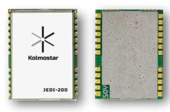
Ultra-low-power for wearables
Photo: Kolmostar
The JEDI-200 reduces the energy for one position fix by up to 150x compared to traditional GNSS sensors, providing a positioning solution for location-based internet-of-things applications.JEDI-200 specification highlights include 10-mW ultra-low-power consumption (measured) at 1-Hz navigation rate; 1-second ultra-fast time-to-first-fix from cold start, and 2-meter CEP high positioning accuracy. It supports GPS and BeiDou. It offers 100-byte compressed ephemeris (EPH) to enable A-GPS with speedy download via low-power wide-area network (LPWAN) technologies such as LoRaWAN and narrowband internet of things (NB-IoT). Kolmostar, www.kolmostar.com
Inertial navigation
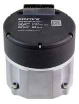
For GPS-denied environments
Photo: Emcore
The EMCORE EN-300 precision fiber-optic inertial measurement/navigation unit is a high-accuracy inertial system designed to be form, fit and function compatible with a legacy equivalent, but with better performance needed for GPS-denied navigation, precise targeting and line-of-sight stabilization. The EN-300 incorporates EMCORE’s proprietary integrated optics devices to enhance performance. The internal signal processing provides full stand-alone or aided navigation, and as an option can provide standard IMU delta velocity and delta theta. With the option of full navigation capability including coning and skulling compensation and sophisticated Kalman filtering, the unit also is able to statically find north to less than one degree through gyrocompassing. Emcore, www.emcore.com
GNSS board
For positioning and heading
Phantom 40. (Photo: Hemisphere GNSS)
The Phantom 40 positioning board is the first Lyra-based offering in a line of low-power, high-precision boards. Its multi-frequency, multi-GNSS receiver processes 700 channels with access to Hemisphere’s Atlas GNSS global corrections network. The 60 x 100 mm module with 24-pin and 16-pin headers is a significant upgrade for existing designs using this industry-standard form factor. The new Lyra II digital ASIC and Aquila wideband RF ASIC designs will be available with the new board, as well as Cygnus interference mitigation technology. Hemisphere GNSS, www.hemispheregnss.com
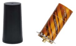
Helical antennas
Available in housed and embedded OEM versions
The new helical antenna in both housed (left) and unhoused form. (Photo: Tallysman)
The first three products of a new range of helical antennas include the HC871, HC872 and HC600. The active GNSS helical antennas feature a low-current, low-noise amplifier (LNA), and include integrated low-loss pre-filters, to protect against harmonic interference from high amplitude interfering signals, such as 700-MHz band LTE and other near in-band cellular signals. The HC871 is a housed, dual-band, active GNSS antenna supporting GPS L1/L2, GLONASS G1/G2, Galileo E1, and BeiDou B1 (25 grams). The HC872 is a housed, dual-band, active GNSS antenna supporting GPS L1/L2, GLONASS G1/G2, Galileo E1, BeiDou B1, and L-Band services (36 grams). The HC600 is a housed, passive Iridium antenna (18 grams). Tallysman, www.tallysman.com
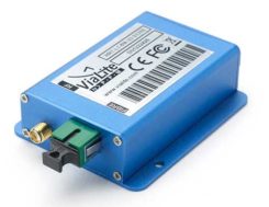
Fiber extension KIT
Carries signals up to 10 kilometers
ViaLiteHD Blue OEM module, one of the available formats for the GPS RF over fiber link. (Photo: VitaLink)
ViaLite’s new GNSS/GPS Fiber Extension Kit has been qualified for use with Microsemi’s timing and synchronization products, and carries timing signals over optical fiber links to 10+ kilometers. The kit includes the ViaLiteHD GPS Link, designed to provide a remote GNSS/GPS signal or derived timing reference to equipment located where there is no reception, such as inside buildings, tunnels and mines. The kit is suitable for GPS, Galileo, GLONASS and BeiDou bands, and the links provide a wide dynamic range with negligible signal degradation from noise or interference. ViaLite, www.vialite.com
SURVEY & MAPPING
Lidar scanner
3D mobile scanner for urban areas, roads
Photo: Viametris
The second generation of the vMS3D lidar scanner is now more compact and simplified in both electronic and ergonomic terms to make it more robust and stable in adverse conditions and challenging environments. Despite being lighter, the second generation offers the same technological capacities as its predecessor, but is simpler to use and can be mounted on a vehicle in minutes. The system component (including the sensors) and the element to affix the device to the vehicle (the frame) previously formed one unit, but are now separated in a design that limits vibrations and prevents any strain on the mechanics during acquisition. The scanner’s receiver is a Septentrio AsteRx-m2a and its inertial measurement unit is an SBG Systems Ellipse2-D. Viametris, www.viametris.com
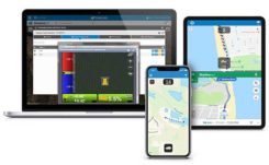
Job-site monitoring
Real-time 3D construction management gets remote support
Sitelink 2.0. (Photo: Topcon)
Sitelink 2.0 is the latest edition of Topcon’s real-time 3D job-site monitoring and management system. The update includes a new pay-as-you-go point-based service model, new features to Sitelink Support Desk, and a new Haul Truck application. Remote configuration via the support desk allows Topcon personnel to directly access and configure receiver components on connected machines, while simultaneously retaining an active remote session of Topcon’s 3D-MC grade-control software for machine control. Topcon, www.topconpositioning.com
Data collector
Connected smartphone for the field
Photo: Trimble
The TDC600 handheld is an ultra-rugged, all-in-one smartphone and GNSS data collector for geographic information system (GIS) and field inspection applications. The rugged handheld runs on Android 8.0 and has a bright sunlight-readable 6-inch display, 2.2-GHz processor, 4-GB memory and an enhanced-capacity all-day battery. It supports the Trimble Catalyst GNSS positioning service that delivers subscription-based accuracy on demand for Android devices. Its built-in receiver supports GPS, GLONASS and BeiDou plus satellite-based augmentation system (SBAS) capabilities for real-time positioning. It is rugged for GIS users in organizations such as environmental management, utilities and government agencies. Wi-Fi, Bluetooth 4.1 and 4G LTE cellular connectivity support data and voice calls, so field workers can use the TDC600 as they would any consumer smartphone, communicating between the field and office, sending emails and texting. Trimble, www.trimble.com
Vehicle scanner
1,200 scan lines per second
Photo: Cepton
The SORA-P60 is designed to provide accurate 3D scans and to enable automated classification of objects and volumetric scanning, including high-velocity vehicle scanning and classification. Cepton’s Micro-Motion Technology (MMT) lidar in combination with its edge-compute hardware SORA-Edge makes it a powerful, mobile object classification and volumetric measurement device that can send its data over Ethernet, Wi-Fi or LTE to a central processing server. The SORA-P60’s three scan lines, each scanning at 400 Hz, enable accurate scanning for classification of objects traveling at highway speeds — 400 Hz translates to a scan line every 5 centimeters for an object traveling at 50 miles per hour. For example, users can measure the size of a tow hitch and trailer on a vehicle traveling on a highway in real time. The SORA-P60 sensor is free of rotational or frictional components, making it impervious to mechanical wear and tear. In addition, the new SORA-P60 features rugged housing designed to withstand harsh environments, cold climates and salt spray. Cepton Technologies, www.cepton.com
UAV
Long-flight demonstrator
Completed maiden flight
Photo: U.S. Defense Department
The XQ-58A Valkyrie from National Security Solutions provider Kratos completed its maiden flight on March 5 at Yuma Proving Grounds in Arizona. Kratos Unmanned Aerial Systems (KUAS) and the Air Force Research Laboratory (AFRL) partnered on the development of the XQ-58A Valkyrie. During its 76-minute maiden flight, the UAV completed its test objectives. The runway-independent UAV is capable of long-range flights at high-subsonic speeds. Its development falls within AFRL’s Low Cost Attritable Aircraft Technology (LCAAT) portfolio, which has the objective to break the escalating cost trajectory of tactically relevant aircraft. Kratos Defense & Security Solutions, www.kratosdefense.com
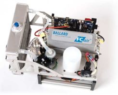
Fuel cells
Long-duration power solution for commercial UAVs
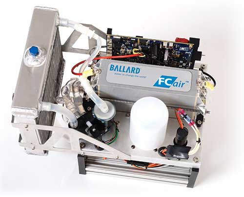
Photo: Ballard
The FCair hydrogen fuel cell can extend UAV flight time to up to 90 minutes, almost three times that of lithium-ion battery-powered drones. The product line includes FCair-600 and FCair-1200 liquid-cooled fuel-cell power systems, with built-in hybrid battery control and charging and delivering 600 and 1200 watts of power, respectively. These systems are in ongoing field trials, having previously been proven in harsh environments and at high altitudes. FCair includes a hydrogen fuel-cell power system, hydrogen storage vessels, pressure regulators, refueling solutions and hydrogen gas supply. The product line supports commercial UAV manufacturers and operators in the delivery of fuel-cell-powered UAV benefits, including: three times the flight duration of batteries; five times the reliability and a fraction of the noise of small internal combustion engines; and significantly reduced operational expenses. Ballard, www.ballard.com
Lidar platform
Compact for uav deployment
Photo: Teledyne
The CL-90 is a lightweight compact lidar platform for UAV deployment. It features exceptional canopy penetration, offering low-noise, high-quality survey-grade data to deliver high-quality performance in data accuracy and point precision. The CL-90 provides full lidar performance across the entire operating altitude range of the UAV, and offers a variable field-of-view capability that eliminates the need for multiple passes over a target. Teledyne, www.teledyne.com
Drone countermeasure
Lightweight, compact handheld gun
Photo: DroneShield
DroneGun MKIII is a portable pistol-shape drone jammer weighing under 2 kg. DroneGun MKIII is designed to be an alternate product rather than a replacement for the previously released DroneGun Tactical unit. It has a shorter effective range of 500 meters versus 1–2 kilometers for DroneGun Tactical. DroneGun MKIII can be used in combination with other DroneShield products, including the RfPatrol body-worn detection device and the DroneSentinel stationary multi-sensor detection system. DroneShield Ltd., www.droneshield.com
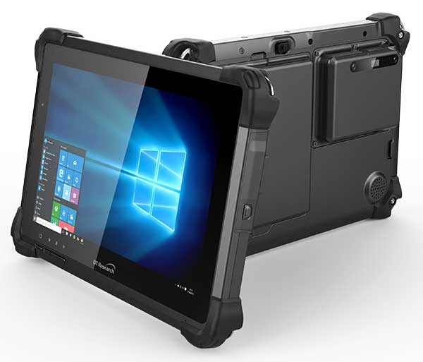
DT Research has designed a new rugged tablet with 3D imaging that is purpose-built for 3D mapping with a built-in GNSS module.
The DT301X has an Intel RealSense Depth camera that provides real-time 3D imaging combined with dual-frequency GNSS module for real-time mapping and positioning. The digital images are better than high-definition standard, and are suitable for construction building information management (BIM) graphics.
The DT301X rugged tablet is compatible with existing applications with Microsoft Windows 10 IoT Enterprise operating systems for flexible integration, and it brings together the advanced workflow for data capture, accurate positioning and data transmitting.
Key features of the DT301X
Highly durable. IP65 and MIL-STD-810G rated tablet in a slim case offers the versatility to be used in the field, office and vehicles.
Indoor/outdoor display. A high brightness 10.1-inch touchscreen offers flexible viewing in a wide range of lighting.
Wi-Fi and Bluetooth. Long-range Bluetooth for 1000-foot range and 4G LTE mobile broadband for the latest in high-speed communications.
High performance. Intel 8th-generation Core i5 or i7 processor offers high-performance while still being energy efficient.
Hot-swappable batteries. With high-capacity 60- or 90-watt hot-swappable batteries, the DT301X keeps working continuously.