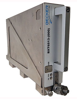
Becker Avionics has received certification for the its BXT65XX Mode S transponder, designed specifically for the rigorous flying environment characteristic of helicopter operations.
Paired with a FreeFlight Systems’ 1203C SBAS/GNSS sensor, the remote-mounted solutions provide helicopter operators a complete and cost-effective way to equip with ADS-B Out to meet the Jan. 1, 2020, mandate.
The system is a part of the company’s robust BXT65XX line of ADS-B Mode S transponders. Manufactured with a standard ARINC 429/743 output, this transponder easily integrates with the FreeFlight Systems Model 1203C SBAS/GNSS sensor for complete ADS-B Out compliance, the company said. It can also be installed either as dual installation for primary transponder interrogations or as single install for a dedicated ADS-B transmission.
The transponder can be installed on aircraft not equipped with a traffic collision avoidance system. Its enhanced privacy settings can disable both ADS-B and Mode S transmissions.
“We are pleased to announce this new milestone in our transponder product line,” said Forrest Colliver, Becker Avionics’ managing director. “This new system showcases how we tailor our compact, robust, and durable avionics to our clients’ requirements in order to provide the best solution for where and how they fly.”
A roundup of recent products in the GNSS and inertial positioning industry from the April 2018 issue of GPS World magazine.
OEM
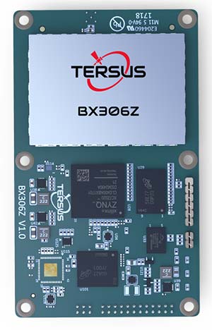
GNSS RTK Board
For OEMs, system integrators
The BX306Z GNSS real-time kinematic (RTK) board has powerful flexibility and compatibility to meet the needs of original equipment manufacturers (OEMs) and system integrators. The BX306Z is a cost-efficient board for positioning and raw measurement output. The board is a compact, multi-GNSS (GPS L1/L2, GLONASS G1/G2, BeiDou B1/B2) RTK module with centimeter-level accurate positioning capability. It is able to integrate with autopilots and inertial navigation units. Log and command is compatible with major GNSS boards.
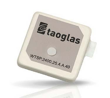
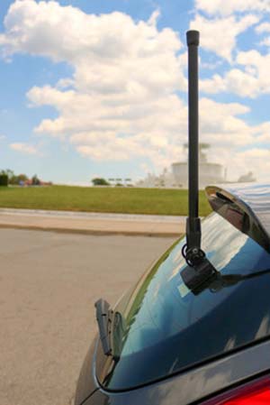
The Taoglas Terrablast antenna line is designed for UAVs and transportation. (Photo: Taoglas)
Rugged antennas
For automotive, drone markets
Terrablast polymer-based patch antennas are 30 percent lighter than their ceramic counterparts and extremely resistant to fracture upon impact. They are designed for the automotive and unmanned aerial vehicle (UAV) markets, where impacts are possible but antenna performance cannot be compromised. The 35-mm GPS/GLONASS/BeiDou patch antenna has high efficiency of more than 70 percent across all bands, improving time to first fix. All Terrablast antennas undergo rigorous temperature, vibration and impact tests, exceed ISO 16750 standards, and are manufactured in Taoglas’ purpose-built facilities in Taiwan and the United States.
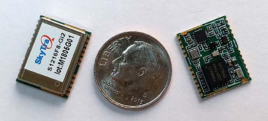
The S1216F8-GI2 is a NavIC + GPS/GAGAN receiver module for emerging intelligent transport systems (ITS) applications requiring NavIC/GPS capability in India. It integrates an L1/L5 RF front-end and baseband processor capable of receiving up to 14 L5 NavIC signals and up to 20 L1 GPS/GAGAN signals simultaneously. With six NavIC signals and three GAGAN signals, it offers 18–23 usable signals, providing improved accuracy in urban canyons. The S1216F8-GI2 is form-factor and pin-out compatible with 12 x 16-millimeter modules, enabling drop-in replacement. NavIC sub-frame data outputs broadcast warning messages for weather alerts and natural disasters. The S1216F8-GI2 is manufactured with ISO/TS 16949 automotive certification.
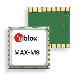
To meet stringent requirements in harsh environments
The automotive-grade MAX‑M8Q‑01A GNSS module measures 9.7 x 10.1 x 2.5 millimeters and has an operating temperature range from –40° C to 105° C. It is designed to meet the stringent requirements of the automotive market, providing superior positioning accuracy even in challenging environments such as urban canyons. Its temperature range ensures reliable performance in harsh environments, such as when mounted in a car‑roof antenna.
The Teseo APP receiver enables safer autonomous driving. The multi-frequency GNSS receiver chipset is suitable for safety-critical automotive applications and high-accuracy positioning at the decimeter and centimeter levels for precise point positioning (PPP) and RTK applications. By tracking satellites of all GNSS constellations simultaneously on at least two of the frequencies used by each system, ST’s automotive-quality Teseo APP (automotive precise positioning) receiver provides high-quality raw GNSS data for PPP and RTK algorithms, which allows accurate positioning and rapid convergence time worldwide. The receiver monitors the integrity of the satellite data to alert the system if accuracy is degraded for any reason. This permits Tier-1 manufacturers to certify safety-critical systems in accordance with ISO 26262.
Qinertia post-processing kinematic software has been designed to help surveyors get the most of their surveys. After the mission, Qinertia gives access to offline real-time kinematic (RTK) up-to-date corrections from more than 7,000 base stations in 164 countries. By creating a virtual base station near a project, the software delivers the highest level of accuracy without having to set up a base station. An advanced tight coupling algorithm delivers high accuracy and maximizes RTK availability. Trajectory and orientation are greatly improved by processing inertial data and raw GNSS observables in forward and backward directions, especially in challenging environments. With Qinertia, surveyors can quickly identify and solve issues such as mechanical installations or sensor alignment.
The T300 Plus GNSS receiver is designed for demanding surveying tasks, with full-constellation tracking capability, tilt compensation, 4G/Wi-Fi connection, 8-GB internal memory and an easy survey workflow with Android-based Survey Master Software. It is designed to make collecting accurate data easy and fast, whether done by a beginner or experienced professional surveyor. As an upgrade of the T300, SinoGNSS T300 Plus combines a GNSS board, Bluetooth and adjustable TX&RX UHF, Wi-Fi and 4G modem into one rugged device. Its built-in 4G modem ensures the T300 Plus works with all kinds of continuously operating reference stations (CORS) worldwide. A built-in tilt sensor supports maximum 30° pole tilt and keeps the compensation accuracy within 3 centimeters; the user can check the electronic bubble on the controller for fast surveys in the field.
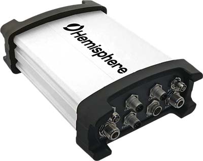
Atlas-capable GNSS receiver for precision 3D applications
The Vector V1000 GNSS receiver is designed for precision marine applications, such as hydrographic and bathymetric surveys, dredging, oil platform positioning, buoys and other applications that demand the highest level 3D positioning accuracies. It provides high-accuracy heading, position, pitch, roll and heave data. The V1000 supports multi-frequency GPS, GLONASS, BeiDou, Galileo, QZSS and IRNSS (with future firmware upgrade and activation) for simultaneous satellite tracking. The receiver is powered by Hemisphere’s Athena real-time kinematic (RTK) engine and is Atlas L-band capable. Based on Hemisphere’s Eclipse Vector technology, the V1000 uses the most accurate differential corrections including RTK and Atlas L-band. It has an integrated display that can be conveniently installed near the operator. The V1000 has heading accuracy of better than 0.01 degree when using a 10-meter antenna separation.
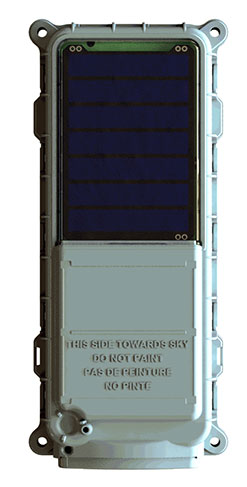
Machine-to-machine (M2M) and internet of things (IoT) device
The SmartOne Solar M2M/IoT device is solar-powered and offers Bluetooth Low Energy connectivity while addressing the growing global demand for reliable and affordable remote monitoring and automated data collection of assets located both within and beyond terrestrial networks. The SmartOne expands the market for remote connectivity to include assets that are otherwise difficult or expensive to reach for power replacement, and lowers the operating cost of monitoring assets being served by legacy SmartOne products. SmartOne Solar’s rechargeable batteries can deliver more than eight years of serviceable life. Without exposure to the sun, a fully charged unit can operate for many months while reporting twice daily. The product’s Bluetooth connectivity allows wireless device configuration and firmware upgrades in the field.
Designed for large-scale surveying and mapping projects
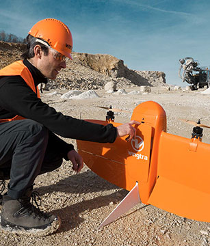
The WingtraOne post-processed kinematic (PPK) drone is the result of collaboration with Pix4D and Septentrio. It is able to deliver orthomosaic maps and 3D models with an absolute accuracy down to 1 centimeter (cm), offering broad coverage and high resolution with ultra-precise accuracy. The WingtraOne can cover 130 hectares (320 acres), equivalent to 240 football fields, in a one-hour flight, and deliver maps at ground sample distances below 1 cm/pixel. Vertical take-off and landing (VTOL) offers hands-free operation and a smoother ride for onboard sensors as well as greater coverage than comparable multi-rotor UAVs. PPK computes ultra-precise geolocations for each image by combining the GNSS data with correction data from a nearby reference receiver. It offers a root-mean-square (RMS) error of 1.3-cm horizontally and 2.3-cm vertically without any ground control points.
DroneHunter is a fully autonomous UAS airspace defense solution. The intelligent robotic aircraft is enabled with TrueView radar designed and engineered for physical remediation of intruder or threatening drones. DroneHunter is an autonomous UAS perimeter detection and protection solution designed to quickly detect, classify and secure against drones and other UAS. When an intruder drone is discovered, DroneHunter can engage autonomously via artificial intelligence (AI)-directed detection, tracking and guidance. Once the rogue drone is identified and the threat level analyzed, DroneHunter safely remediates the threat day or night, at a safe stand-off distance, with no collateral damage. DroneHunter supports multiple drone platforms based on use-case requirements.
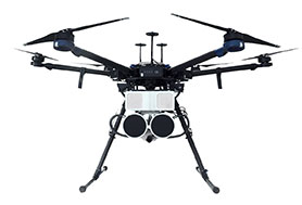
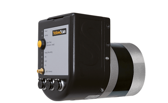
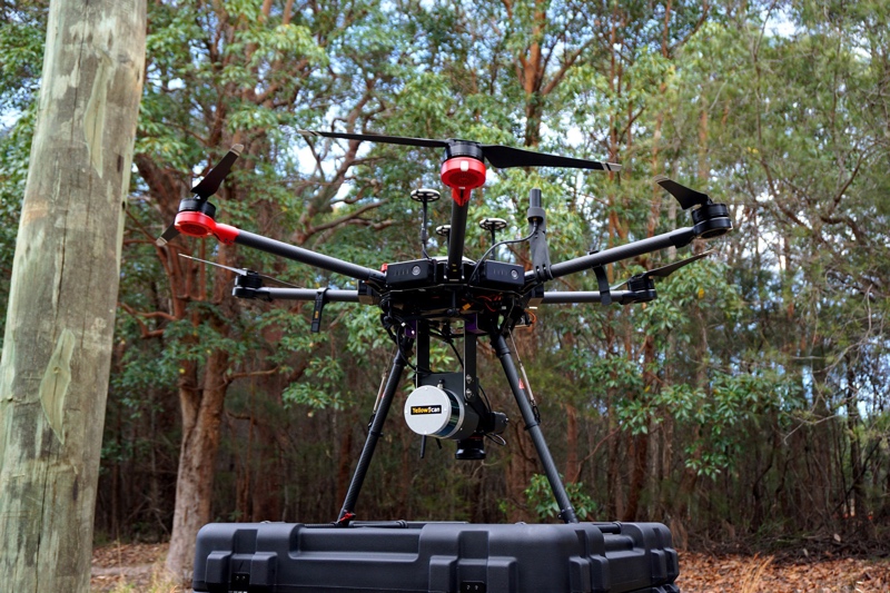
YellowScan has launched a new lidar system, the Surveyor Ultra. It integrates the Velodyne VLP-32C scanner and the Applanix APX-15 GNSS/inertial measurement unit (IMU).
With high density (600,000 shots per second), the system is suitable for high-speed UAVs and long-range needs (maximum range: 100 meters). Its light weight (1.7 kg) makes it easy to mount on any drone, including vertical takeoff and landing (VTOL) UAVs.
As for all YellowScan lidar systems, the Surveyor Ultra is a turn-key system fitted for under vegetation 3D modeling and fast data processing, the company said.
Applications such as forestry, archeology and environmental research will benefit from Surveyor Ultra, as they require long-endurance flights high above trees or over rocky mountains and rugged terrain.
“The Surveyor Ultra shows great potential to safely and efficiently operate lidar on lightweight fixed-wing UAVs,” said Tristan Allouis, YellowScan CTO. “The Surveyor Ultra completes our product line, including the successful Surveyor Lidar System (integration of the VLP-16 scanner from Velodyne).”
Topcon Positioning Group has added a new laser series to its RL-H line of self-leveling rotating lasers.
The RL-H5 series is designed for high-accuracy and long working range in laser applications for grading, excavating and general construction projects. The new offering includes instruments to support diverse jobsite demands.
Lasers in the series include options in working range of up to 800 meters and up to 100 hours of battery life. The RL-H5A with ±1.5 mm at 30 m horizontal accuracy will be available in the Americas, Europe and Oceania. An additional option, the RL-H5B, with ±3 mm at 30-m horizontal accuracy, will be available in the United States and Oceania.
“The RL-H5 builds on what Topcon has been bringing to the market for years and pushes the contractor’s productivity capabilities to the next level. It is another example of our commitment to The Intersection of Infrastructure and Technology, the point at which construction productivity can be improved by applying advanced positioning technology,” he said.
The series is covered by the five-year guarantee on Topcon manufactured lasers.
Viametris, specialist of SLAM-based mobile scanning systems, has launched a backpack-based scanning system called the bMS3D-360. The company continues to rely on SBG Systems’ expertise in inertial navigation by integrating the Ellipse2-D, an inertial navigation system with embedded real-time kinematic (RTK) GNSS receiver.
Photo: Viametris
Viametris has been developing SLAM-based scanning systems for more than 10 years, including the iMS3D, a full indoor mapping system and the VMS3D, a car-based mapping system.
The bMS3D-360 has been designed for the most challenging environments where GNSS is not accessible (indoor) or highly perturbed (urban canyons, forest, etc.). The surveyor starts the system, checks on a tablet that the GNSS and inertial information are computed, and starts the survey.
Back at the office, the user launches the INS/GNSS post-processing software to increase orientation and position accuracy, and then uses the Viametris software to georeference and colorize the point cloud.
Collected data are ready to be imported into common design software. This workflow (from collection to plan drawing) is seven times faster than a traditional method.
The bMS3D-360 offers a 360-degree camera, which greatly simplifies the treatment work. When navigating in the point cloud, the user opens a unique picture of the 360-degree scanned environment instead of looking at four different camera points of view.
Photo: SBG Systems
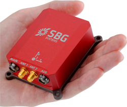
The Ellipse2-D from SBG Systems is a compact inertial navigation system integrating an L1/L2 GNSS receiver. This industrial-grade INS computes roll, pitch and heading as well as position because of its embedded Extended Kalman Filtering.
In real time, Ellipse2-D orientation data are used to correct the equipment attitude and help the SLAM computed heading. The embedded GNSS receiver provides absolute positioning to the point cloud as well as altitude constraint.
When the GNSS faces sources of disturbance, the INS maintains the trajectory were the SLAM technology is limited.
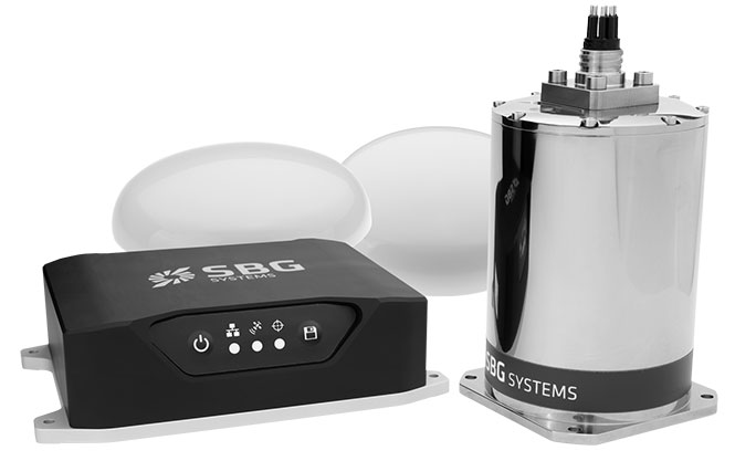
SBG Systems has released the Navsight marine solution, a full high-performance inertial navigation solution designed to make surveyors’ tasks easier in both shallow and deep water.
Navsight consists of an inertial measurement unit available at two different performance levels (from shallow to deep water). According to SBG Systems, the Navsight marine solution is based on 10 years of the company’s experience in marine inertial sensing products.
Whether the IMU comes with a surface or a subsea enclosure, they are all lightweight and easy to install, the company said. Navsight connects to any computer, with no software installation. Once connected through Ethernet, the web interface guides the user to configure the solution.
A 3D view of the boat shows the entered parameters so that the user can check in real time the installation. Navsight allows quick installation and initialization thanks to new mechanical calibration module. The embedded filtering controls and validates lever arms and antenna alignment during this procedure.
Navsight Marine Solution provides high-performance motion and navigation data as well as a real-time heave accurate to 5 cm, which automatically adjusts to the wave frequency, SBG Systems said.
To allow surveying when wave frequencies are large or complex, Navsight comes with a delayed heave feature resulting in a heave accurate to up to 2-cm computed in real-time with a little delay.
If higher performance is required, the surveyor can count on SBG INS/GNSS post-processing software named Qinertia. By processing inertial and GNSS raw data forward and backward, Qinertia greatly increases accuracy especially during GNSS outages; it also fixes set up mistakes.
Highly versatile, Navsight comes as a Motion Reference Unit, providing roll, pitch and heave or as a full navigation solution with embedded tri-frequency GNSS receiver, or using an external one. Fusing inertial data with satellite position in real-time, Navsight INS offers continuous position in all conditions, such as surveying under a bridge, or during a GNSS outages due to coastal infrastructures (buildings, harbor cranes, etc.).
The Navsight Marine Solution supports RTK and every precise point positioning service (Marinestar, TerraStar, etc.). It is compatible with the main hydrographic software such as Hypack, QINSy or Teledyne PDS for seamless integration into existing workflows.
Navsight is ITAR-free. All models are available for order. Ordering information and delivery time are available from SBG Systems representatives and authorized SBG Systems dealers.
The Hibiki processors can take input from up to four frequency GNSS signals simultaneously.
The Hibiki front-end can process up to four GNSS signals for software receivers. (Image: Lighthouse)
The Japanese Quasi-Zenith Satellite System (QZSS) broadcasts GNSS signals in four frequency bands: L1, L2, L5 and L6. Similarly, GPS and GLONASS broadcast in three bands, and the European Galileo and Chinese BeiDou systems broadcast in four bands.
However, many conventional front-ends process only two bands at the same time, and cannot be used for highly specialized applications such as processing multiple signals with different frequencies at the same time.
The Hibiki front-end processor was designed to answer to this GNSS technology demand and is able to process up to four frequency bands simultaneously, the company said.
Hibiki has a high data transfer rate performance using USB 3.0, stably transmitting signal data to the host computer up to 50 million samples per second. This high sampling frequency is much greater than conventional front-end processors, improving L5 signal-receiving performance and reducing multipath.
Wingtra has officially launched the WingtraOne PPK high-precision mapping drone. Wingtra said its drone, which features vertical take-off and landing, is designed to set a new benchmark for large-scale surveying and mapping applications.
WingtraOne PPK offers large area coverage, ultra-high accuracy and brilliant image resolution. It features an advanced PPK module and high-quality cameras like the 42-megapixel full-frame camera Sony RX1RII, it is now possible to reach down to 1-centimeter absolute accuracy in aerial mapping.
To prove this accuracy claim, the Wingtra team performed test flights in a gravel quarry. The process was documented and is now explained in a white paper on the company website.
Conventional drone mapping on centimeter accuracy requires ground control points (GCPs) to correct the final map. Besides requiring additional surveying equipment and being extremely time consuming, setting up GCPs might be downright risky or just not possible in the area of interest.
More advanced solutions achieve similar levels of accuracy by using GPS correction technology for the georeferencing of the aerial imagery: namely RTK (real-time kinematics) or PPK (post processed kinematics).
RTK requires real-time base station connectivity and corrects GPS signals during the flight, while PPK corrects them after the flight and therefore offers greater robustness and consistency.
Moreover, PPK is independent from base stations or base station networks. It is highly reliable, accurate and time saving to use, Wingtra said. Neither special flight preparations nor intensive post-processing steps are required to achieve down to 1-cm accurate aerial maps.
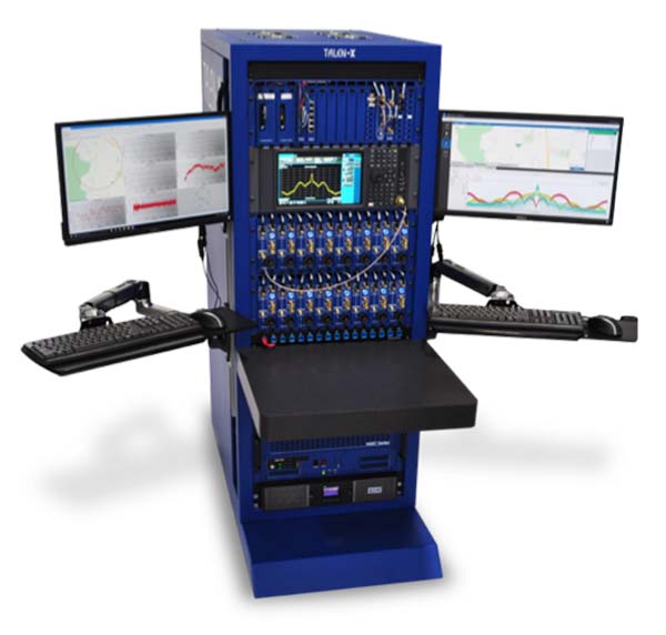
In mid-2017, Talen-X and Skydel engineers began to conceptualize a GNSS simulation system emanating from their BroadSim platform for the purpose of fortifying anechoic chambers.
Over the next six months, Talen-X and Skydel designed, built, tested and delivered an anechoic chamber simulator capable of simultaneously generating multi-GNSS jamming and spoofing signals.
BroadSim Anechoic can be used to support a wide variety of operational tests.
“Our new Anechoic Chamber solution will radically change the way in which mission critical platforms and systems are tested because we are enabling our customers to create real-world threats,” said Talen-X Chief Technology Officer Tim Erbes said. “Not only will BroadSim Anechoic be able to emulate real-world threat scenarios, it will be easier than ever before to create and simulate these environments.”
BroadSim Anechoic is used to test GNSS spoofing and jamming in an anechoic chamber. The BroadSim Controller is at the heart of the system running Skydel’s SDX software suite. Using SDX, users can create advanced scenarios that include both jamming and spoofing signals.
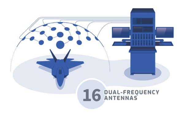
The 16 software-defined radios (SDRs) each with dual transmit ports (32 total outputs) can be configured to output GNSS or jamming signals, giving users flexibility to run test after test. The transmit chains include the hardware to power 16 dual-frequency antennas. The included GNSS receivers allow users to monitor the environment inside the chamber, providing confidence that tests are running correctly.
The BroadSim Anechoic can also be used in controlled radiation pattern antenna (CRPA) testing. Many ground-, airborne- and water-based platforms are transitioning to using CRPAs because of their added jamming resiliency and significant tracking advantages in degraded environments.
Validation and real-world testing is critical to understanding and characterizing the mitigation these antennas can add in highly degraded areas. By using BroadSim Anechoic, users have the ability to create representative jammers with real-world characteristics (modulations, frequencies, angles, power levels, etc).
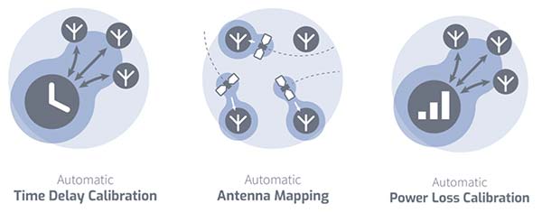
“Skydel developed an innovative approach for time offset calibration between multiple transmitting antenna using a COTS Software-Defined Radio (SDR),” said Skydel Solutions Chief Technology Officer, Iurie Ilie. “This approach allows for very precise measurements and adjustments (better than 100ps) to be done automatically before simulation start. At the same time, transmitting signal power is automatically adjusted to keep the power offset at receiving antenna better than 0.1dB.”
BroadSim Anechoic takes advantage of state-of-the-art software defined radios (SDR) for RF up-converting while signal IQ generation is done using high performance commercial-off-the-shelf (COTS) graphics-processing units (GPU). The ability to generate the IQ data in software (using the GPU) as opposed to hardware (FPGA) significantly reduces the cost while maximizing capability, value, and time to market.
BroadSim Anechoic has the capability of powering up to 16-dual frequency antennas requiring 32 RF transmit outputs. The architecture used for this system required the ability to receive signals in a manner such that precise processing could be done on the receive signal.
The SDR selected for this application has one receiver channel for every transmit channel giving BroadSim Anechoic 32 RF receive ports. Innovative software techniques have been developed enabling the accurate time and power calibration for each antenna transmit chain using the SDR receive ports.
SuperSurv’s NTRIP solution is being enhanced to adopt more RTCM versions and provide a better GNSS positioning service. NTRIP (Networked Transport of RTCM via internet protocol) is a protocol to send GNSS-related data through the internet, which enables users of differential GPS or network real-time kinematic (RTK) to get correction parameters after connecting to the internet. The correction parameters can be used to calculate a more accurate GNSS location. Supergeo’s product team is developing the support for RTCM 3.1, including Types 1021 and 1023.
The scalable A222 GNSS smart antenna is designed for both agriculture and basic indicate systems markets, as well as other markets requiring flexible positioning. The smart antenna has the flexibility to scale and grow as business expands and can be configured from L1-only to multi-GNSS, multi-frequency and real-time kinematic (RTK). It adds a system component so that tractor and farm equipment manufacturers can deliver their own guidance and control solutions to their customers. Designed to excel in challenging environments, the A222 uses Hemisphere’s Athena RTK engine and is Atlas L-band capable. It is easy to mount and customizable. Its dual-serial, CAN and pulse output options are compatible with almost any industry-standard interface. Because the A222 is Atlas-capable, it has the ability to use the new Atlas AutoSeed technology. Atlas AutoSeed allows users to suspend Atlas use for any period, and upon returning to their last location, AutoSeed rapidly re-converges to a high-accuracy converged position. A222 comes pre-configured with Atlas Basic activated.
Locates mobile devices moving indoors and outdoors
Leveraging ubiquitous LTE signals, the Lite-Touch Architecture calculates positioning in the cloud to efficiently locate devices between indoor and outdoor environments. By offloading computation-heavy location calculations from the device to the cloud, the PoLTE positioning solution makes location positioning available to a wider variety of devices, including those constrained by battery life, memory, processing power, size and cost. This includes IoT-based applications that historically relied on GPS, with its high rate of power consumption, as well as Wi-Fi and Bluetooth with their added size, cost and network complexity.
Enhancements to the SyncServer S600 series of time servers and instruments improve time synchronization over enterprise Ethernet networks and supply timing signals for improved military radar operations and satellite uplink communications. The SyncServer S600 series also meets the timing and synchronization needs of the rapidly evolving networks of enterprise and financial customers, particularly for compliance purposes such as the European MiFID II directive, which specifies highly stringent time accuracy requirements for stock trading systems. The latest release includes support for the IEEE 1588 multiport, multi-profile Precision Time Protocol (PTP), which allows the S600 to operate as an independent grandmaster clock on each Ethernet port — delivering cost savings and network deployment flexibility to customers. This is coupled with a new 10-GbE interface to easily interoperate with a wider variety of network and stock trading topologies.
The HG4930 inertial measurement unit (IMU) is tailored for “straight-out-of-the-factory” integration and use in various non-defense and non-aerospace industrial applications including surveying and mapping, autonomous vehicles and gimbal stabilization. The HG4930 IMU is not classified under an International Traffic in Arms Regulation category; it is free from the burden of an export license for all but a few military-related use cases. The micro-electro-mechanical system (MEMS)-based IMU has been tailored to provide significantly improved gyroscope and accelerometer performance for the environments and use cases experienced by non-aerospace and non-defense users.
The HX-DU2017D is a frequency-hopping OEM modem designed to provide strong anti-jamming and signal receiving capability for complex data-intensive applications. HX-DU2017D is a miniature, dual-frequency, software-selectable 840-MHz and 900-MHz data link modem. It provides power switching of 0.5 W, 1 W and 2 W; 20 ms/30 ms/40 ms/50 ms/ frequency-hopping intervals; and supports point-to-point, point-to-multipoint network. Its full duplex mode ensures secure data transferring and stable long-range communication. The HX-DU2017D also provides short latency of data transmission and communication recovery in millisecond level. It allows fast and secure simultaneous data communication for mission-critical applications, especially in the fields of precision agriculture and UAVs, including unmanned plant surveys, UAV plant protection and automatic mowers. It could be placed on a UAV with its extremely small footprint for tight OEM integration and design flexibility. Meanwhile, its frequency-hopping transmission ensures UAV data security and flight stability.
For small construction, thermal inspections and public safety
The Parrot Bebop-Pro Thermal is a compact quadcopter with two embedded cameras: a stabilized 14-megapixel high-definition front-facing video camera and a FLIR ONE Pro thermal camera. The thermal-imaging camera is positioned in a dedicated module at the back of the drone. Three thermal-imaging setting modes are available: Standard, Dynamic and Hotspot. The Parrot FreeFlight Thermal app innovatively transmits and analyzes images captured by the quadcopter’s cameras. Included is a long-range Parrot Skycontroller 2 remote control.
Pergam gas sensor integrated with carbon-fiber UAV
Pergam gas sensor aboard the Microdrones md4-1000 UAV.
The aerial methane detector mdTector1000 CH4 detects methane gas via a fully integrated aerial package. It has a Pergam gas sensor, mounted and integrated with the Microdrones md4-1000 UAV. In real time users can see aerial shots of detection with the laser sensor. The carbon-fiber-built UAV goes into dangerous areas unsuitable for workers. The mdTector1000 CH4 can be used for natural gas line surveys, tank inspections, gas well testing, plant safety and landfill emission monitoring. The mdCockpit Android app allows users to maintain visualization in flight. A special mdTector app allows users to visualize and present all post-flight data on one map.
Microdrones, www.microdrones.com
UAV tracking antenna
Portable antenna for unmanned or manned aircraft
The Octopus UAV portable tracking antenna enables long-range data transmission and is suitable for unmanned and manned aircraft applications. It has a range of more than 100 kilometers and an integrated pointing algorithm. The GPS location of the aircraft is sent over the Airlink IP datalink and received directly by the tracking antenna, making it operational with any existing unmanned aircraft autopilot system. For a manned aircraft, an existing GPS receiver or dedicated GPS receiver can be used.
Brings high-precision positioning and attitude to small UAVs
AsteRx-m2 UAS receiver.
The AsteRx-m2a UAS GNSS OEM engines provides precise and reliable multi-frequency, all-in-view real-time kinematic (RTK) positioning and heading — along with interference technology — with low power consumption. It features Septentrio’s AIM+ interference mitigation and monitoring system, which can suppress a wide variety of interferers. It is designed to bring high-precision positioning and attitude to any space-constrained application, offering a high update rate and low latency output. The AsteRx-m2a UAS provides plug-and-play compatibility for autopilot systems such as ArduPilot and Pixhawk. Event markers accurately synchronize camera shutter events with GNSS time. The board can be powered directly from the vehicle power bus via its wide-range input. It works seamlessly with GeoTagZ software, providing offline re-processed RTK accuracy without the need for either ground control points or a real-time datalink.
The GPS-TMG-HR timing antennas are designed for Positive Train Control and railroad management, among other markets. They are equipped with high-rejection narrowband filtering to mitigate interference and provide 65-dB rejection of frequencies adjacent to L1 GPS. The GPS-TMG-HR maintains all features of PCTEL’s GPS timing reference platform. The antennas feature a 26-dB amplifier (GPS-TMG-HR-26N) and 40-dB amplifier (GPS-TMG-HR-40N ) and narrowband high rejection filtering to support long-lasting, trouble-free deployments in congested cell-site applications with severe interference around the GPS L1 frequency. The proprietary quadrifilar helix design, coupled with multi-stage filtering, provides superior out-of-band rejection and lower elevation pattern performance than traditional patch antennas.
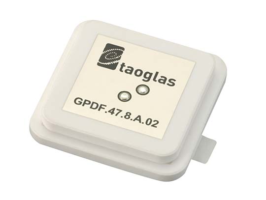
The GPDF.47.8.A.02 is a ceramic GPS L1/L2 / Galileo low-profile, low-axial ratio, embedded stacked passive patch antenna. It is 47.5 x 47.5 millimeters wide and 8 millimeters thick. It is designed for the highest accuracy centimeter-level tracking in telematics applications for positioning technologies. Typical applicable industries are transportation, defense, marine, agriculture and navigation.
The Autonomy Development Platform provides automakers, truck makers and Tier 1 vehicle suppliers the hardware, software, engineering and integration services they need to accelerate development programs for on-road and off-road autonomous vehicles. By combining customized integration and engineering services with GNSS-inertial positioning technologies, the Autonomy Development Platform advances driverless vehicle development projects at every stage of development and commercialization. The platform delivers a navigation solution that is fully customizable and includes integration and engineering services, field-tested hardware and proprietary software for highly accurate positioning. The solution is capable of working with all sensors, including multiple cameras, lidar, radar and ultrasonic sensors, and with all vehicle types at all stages in the development and commercialization cycle. Also, the technology enables highly accurate assessments of the full 360-degree environment around a vehicle to produce a robust representation, including static and dynamic objects, which is critical for successful vehicle autonomy.
TomTom AutoStream is a map delivery service for autonomous driving and advanced driver assistance systems. The service enables vehicles to build a horizon for the road ahead by streaming the latest map data from the TomTom cloud. TomTom AutoStream ensures that the TomTom map data used to power advanced driving functions is the latest, most accurate available, enabling a safer and more comfortable experience. The map-data stream can be customized based on criteria such as sensor configuration and horizon length. It can stream a wide variety of map data including advanced driver assistance systems (ADAS), attributes such as gradient and curvature, and the TomTom HD Map with RoadDNA. This flexibility allows customers to use AutoStream to power a wide range of driving automation functions.
Esri, the spatial analytics company, has publishedThe GIS 20: Essential Skills, Third Edition, a book designed to quickly prepare those who need to use a geographic information system (GIS).
The GIS 20 is aimed at readers who are new to or unfamiliar with GIS, such as a professional interested in using the technology on the job to conduct analysis and create maps, or a student majoring in a subject other than GIS who could benefit from geospatial knowledge.
Avoiding a focus on the inner workings of a GIS and sticking instead to teaching the tasks and functions most frequently and commonly used, this quick-start guide provides clear, step-by-step instructions on how to do common GIS tasks.
These include downloading shapefiles and using essential tools in the software, preparing data for a map, geocoding addresses, making thematic and other types of maps, mapping latitude and longitude points collected with a GPS, using aerial photography in maps, and publishing maps.
Author Gina Clemmer is president of New Urban Research, Inc., a social research and training company based in Portland, Oregon. She has spent her career teaching everyone from executives in New York City to residents of fishing villages in Alaska to how understand the core concepts and use the tools of GIS for decision-making.
“This book is an extension of my passion to help everyday people quickly learn the fundamentals of ArcGIS,” Clemmer wrote in The GIS 20. “Once you see the power of GIS and see that you yourself can create maps easily, you simply can’t unsee it. GIS will change the way you think about presenting data and solving problems.”
The GIS 20: Essential Skills is available in print (ISBN: 9781589485129, 180 pages, US$49.99) and as an e-book (ISBN: 9781589485136, 180 pages, US$49.99). The print and e-book editions of the book can be obtained from online retailers worldwide, at esri.com/esripress, or by calling 1-800-447-9778. Outside the United States, visit esri.com/esripressorders for complete ordering options, or visit esri.com/distributors to contact your local Esri distributor. Interested retailers can contact Esri Press book distributor Ingram Publisher Services.
Danlaw Inc. has released its Through Glass Integrated V2X Antenna for vehicle-to-vehicle and vehicle-to-everything (V2X) communications.
The design incorporates an integrated GNSS antenna on the interior coupler. Optional cellular, Wi-Fi, and other antennas are also available on request.
The antenna pairs with dedicated short-range communications (DSRC) devices to enable vehicle-to-vehicle, and vehicle-to-infrastructure communications.
Traditional aftermarket antennas require drilling holes or passing cables through window and door openings, which risks damaging vehicle seals.
Danlaw’s dual-radio, glass-mounted antenna eliminates the risk of damaging the vehicle by using a coupling pair-to-pass DSRC signals between the vehicle’s interior and exterior.
The easy-to-install antenna can be mounted on the rear, front or side windows using automotive grade glass adhesive. This flexible installation allows the shortest cable route to the V2X device, reducing signal losses due to cable length, the company said.
“Our customers running pilot programs want to install V2X DSRC systems on vehicles with best-in-class RF performance without modifying their cars,” said Scott Morell, Danlaw’s vice president of engineering. “Combined with our Aftermarket V2X Safety Device, this enables V2X capabilities to be installed on vehicles simply and easily.”
The antenna enhances Danlaw’s Connected Vehicle portfolio which includes an aftermarket safety device (ASD) and V2X development tools.
The ASD has been selected by pilot programs supporting multiple applications, including critical safety advice, driver access solutions, and real-time road condition and congestion information.
Danlaw development tools include the OmniAir-certified Mx-DSRC Conformance Test System and Mx-Drive Mobility Simulator.
Detailed specifications for the antenna are available.
 Becker Avionics has received certification for the its BXT65XX Mode S transponder, designed specifically for the rigorous flying environment characteristic of helicopter operations.