MEMS-based sensing solutions company Acienna released OpenIMU, a professionally supported, open-source GPS/GNSS-aided inertial navigation software stack for low-cost precise navigation applications.
Integrating an inertial measurement unit (IMU)-based sensor network will greatly improve its navigation and self-location capabilities, Acienna said.
It is aimed at developing autonomously guided vehicles for industrial applications, autonomous cars, factory or industrial robots, drones, remotely operated underwater vehicle or any kind of smart machine that needs to move fast or slow, on land, in the air or in water.
“Our breakthrough open-source software for INS/GPS algorithm development is the first professional grade open-source navigation stack running on a low-cost IMU,” said Mike Horton, CTO of Aceinna. “Not only will this kit save developers time and money, it is simple to use and does not require a Ph.D.”
OpenIMU enables advanced, easy-to-deploy localization and navigation algorithm solutions for a fraction of the time and cost of traditional methods, Aceinna said.
OpenIMU’s combination of open-source software and low-cost hardware enables rapid development of advanced solutions for drones, robotics, and autonomous applications. Its extensible software-infrastructure provides all the code needed for algorithm development.
The freely downloadable stack includes:
FreeRTOS-based data collection and sampling engine
Free IDE/compiler tool chain based on Visual Studio Code
JTAG debugging for debugging code loaded on IMU
Data logging, graphing, Allen Variance plots and maps
Extensive documentation
Robust simulation environment with advanced sensor error models
To install OpenIMU stack now, follow the directions. Several ready-to-install free GPS/INS and IMU applications are available at Aceinna’s Navigation app store.
The OpenIMU Development hardware development kit includes JTAG-pod, precision mount fixture, EVB and an OpenIMU300 module.
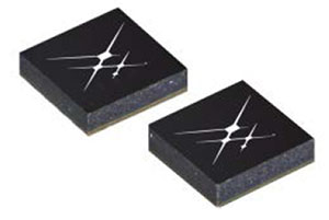
The OpenIMU module features Aceinna’s 5 deg/Hr, 9-Axis gyro, accelerometer, and magnetometer sensor suite with an onboard 180-MHz ARM Coretex floating-point CPU.
The IMU is delivered in a 24 x 37 x 9.5 millimeter module that operates at 2.7-5.5 VDC.
The OpenIMU Development kit is available for immediate delivery.
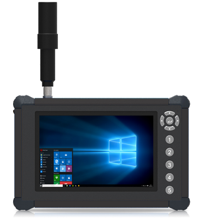
DT Research has launched the DT372AP-TR rugged real-time kinematic (RTK) tablet, a lightweight military-grade tablet that offers RTK to enhance the precision of position data derived from satellite-based positioning systems.
The tablet enables 3D point cloud creation with centimeter-level accuracy to meet the high standards required for scientific-grade evidence in court, the company said.
The DT372AP-TR RTK tablet is military-grade with an IP65 rating, yet lightweight — offering the versatility to be used in the field, office and vehicles.
A dual-frequency GNSS module is built into the tablet, which uses real-time reference points within 1- to 2-centimeter accuracy to position 3D point clouds created from aerial photogrammetry, using GPS, GLONASS and Galileo satellites. Users can measure with the RTK GNSS positioning directly using an external antenna for better survey-grade precision.
“We designed a more compact tablet that still offers all the functionality of a rugged RTK tablet, to give ultra-mobility to law enforcement and first responders who are already weighed down with heavy equipment,” said Daw Tsai Sc.D., president of DT Research. “With programmable side buttons and directional pad, this tablet combines ease of use with a small form factor and centimeter level accuracy, there is nothing in the market now in the same category that can offer this combination.”
The DT372AP-TR RTK tablet is compatible with existing survey and GIS software for mapping applications and brings together an advanced workflow for data capture, accurate positioning and data transmitting.
The tablet can be used in a variety of scenarios, including:
Forensic mapping. Public safety teams, investigators and crash reconstructionists can use the DT372AP-TR to accurately collect measurements that are scientifically and legally defensible by using the real-time centimeter reference points to position 3D point clouds created from aerial photogrammetry or take stand-alone measurements. By using the tablet with a drone for crime and crash scene investigation, cost goes down while accuracy and speed improve, helping to clear areas faster, thereby improving overall public safety.
Land surveying. Surveyors can use the DT372AP-TR RTK tablet to measure the altitudes, angles and distances on the land surface so that they can be accurately plotted on a map to determine property boundaries, construction layout and mapmaking.
E-construction. Construction workers can manage the collection, review, approval and distribution of highway construction contract documents in a paperless environment using the DT372AP-TR RTK tablet.
The tablet has been purpose-built for precision mapping in a variety of environments and includes the following features and capabilities:
Dual-frequency GNSS module. GNSS L1 and L2 RTK that receives GPS, GLONASS, Galileo, BeiDou and QZSS signals up to 372 channels
High-performance CPU and Windows OS. Intel Pentium processor with Microsoft Windows 10 IoT Enterprise with 8 GB of RAM.
Brilliant sunlight-readable display. A 7-inch LED-backlight, high-brightness (800 nits) sunlight-readable screen with capacitive touch and 1280 x 800 resolution.
Superior wireless connectivity. Long-range Class 1 Bluetooth option powers connectivity up to 1,000 feet.
Mobile broadband option. For best field connectivity, there is an option for 4G mobile broadband for LTE, HESPA+, GMS/GPRS/EDGE, EV-DO, Rev A and 1xRTT.
Military standards. For use in harsh environments, the tablet is fully ruggedized to meet the highest durability standards with an IP65 rating, MIL-STD-810G for vibration and shock resistance and MIL-STD-461F for EMI and EMC tolerance.
High-capacity hot-swappable battery pack. Delivers 60 or 90 watts for up to 15 hours of continuous mobile communications.
Camera option. The optional back camera offers 5 megapixels, CMOS sensor and auto focus to capture project progress or record crash and crime scene details.
Accessories. External antennas, pole mount cradles, battery charging kits and digital pens.
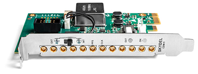
Skydel has released a new clock distribution module for the GNSS industry.
Photo: Skydel
Designed in a PCIe card format, the CDM-5 is a compact and precise clock intended for use with GNSS and other RF systems. It can synchronize up to five devices and can be integrated into custom hardware systems.
Skydel’s CDM-5 provides 10-MHz and 1-PPS signals for up to five devices that need tight and precise synchronization. It is suitable for PCIe-based software-defined radios (SDR) installed in rackmount or desktop PCs, and also can be used for any other applications that require a precise PC-based timing reference.
Skydel’s CDM-5 clock distribution module features two operating modes—internal or external— that are selected with the bracket-mounted switch.
In internal mode, the CMD-5’s internal clock signal is extracted from the onboard high-grade oven-controlled crystal oscillator (OCXO).
When operating in external mode, CDM-5 accepts input signals in the form of 10-MHz and 1-PPS, which are then redistributed via five matched-length traces. Split signals are amplified to maintain the power level across all distributed paths.
Additionally, CDM-5 will regenerate 1 PPS from an external 10-MHz-only source if a 1-PPS source is not available.
The CDM-5 can be integrated into a custom assembly by removing the bracket plate and powering the board through its 12V DC connector. When the bracket is removed, the operating mode can be toggled using the onboard switch.
Key features:
Timing and frequency source with five-way distribution of 10-MHz and 1-PPS signals
PCIe form factor for rackmount or desktop PC
Two operating modes: internal clock (OCXO) or external clock (10MHz and 1PPS)
Supports standalone operation with 12V DC power supply
A roundup of recent products in the GNSS and inertial positioning industry from the September 2018 issue of GPS World magazine.
OEM
Reference receiver
For real-time networks (RTN)
Photo: Trimble
The Trimble Alloy GNSS reference receiver is designed for continuously operating reference stations (CORS). It offers 672 channels and constellation tracking of GPS, GLONASS, BeiDou, Galileo, QZSS, IRNSS and SBAS for robust and reliable reference data. With an IP68 rating for protection against dust and moisture, the Alloy performs in rugged environments to meet the demands of professionals in earth science, surveying, construction, mapping and agriculture. The Alloy allows RTN owners and operators to track and log all current and planned GNSS and deliver absolute position monitoring, as well as centimeter-level accuracy in real time with Trimble RTX precise point positioning technology. Featuring a four-line OLED screen, the receiver displays key information without the need to scroll through multiple menus. Other features include dual hot-swappable batteries, multiple power inputs and serial ports, Wi-Fi connectivity and remote access options.
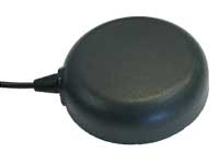
The TW7875 magnetic-mount GNSS antenna is designed for precision dual-frequency positioning. It is capable of receiving GPS L1/L5, GLONASS G1, BeiDou B1, Galileo E1/E5a and NavIC L5. It employs Tallysman’s Accutenna technology, which provides superior multipath signal rejection due to its low axial ratio across the full bandwidth. It also provides a linear phase response and tight phase-center variation. It is designed for precision agriculture, autonomous vehicles and other precision applications. The TW7875 is housed in a magnetic-mount IP67-rated housing, but can also be mounted with screws or adhesive tape. The embedded version, Model TW3875, has a wide selection of connectors and custom cable lengths, and can be custom tuned by Tallysman to ensure optimum performance within the customer’s enclosure.
The SPAN CPT7 provides tightly coupled GNSS+INS navigation technology in a rugged, compact unit. Commercially exportable and designed for integration into a wide variety of applications, it delivers assured positioning anywhere. SPAN technology tightly couples GNSS and inertial navigation system (INS) measurements. The system enables continuous, robust positioning and fast reacquisition in challenging navigation environments where GNSS signals may be unreliable or unavailable for short periods. Dual antennas deliver instant alignment. NovAtel’s OEM7 Interference Toolkit (ITK) provides interference detection and mitigation, with the spectrum analysis function allowing integrators to identify interference within the GNSS frequency bands and implement digital filters to eliminate the problem.
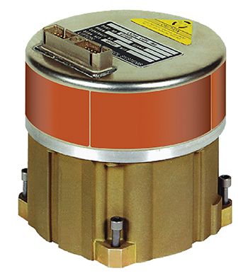
The commercial-off-the-shelf (COTS) LN-200C is a compact and lightweight six-degrees-of-freedom inertial measurement unit (IMU) that can be used for instrument stabilization, motion compensation and navigation in commercial, aerospace and industrial applications. Based on fiber-optic gyro (FOG) technology, the LN-200C IMU’s hermetic seal and lack of moving parts help to ensure low noise and extended operational life. The LN-200C can serve as a drop-in replacement for applications that don’t require the full operational range of the original LN-200 and that can benefit from the expedited licensing and global ease of use offered by the LN-200C.
Global Certification Forum (GCF) protocol conformance tests available
Photo: Rohde & Schwarz
The Rohde & Schwarz CMW500 wideband radio communication tester and SMBV100A GNSS simulator have been expanded to support Global Certification Forum (GCF) protocol conformance tests for C-V2X device certification. Utilizing the Qualcomm 9150 C-V2X chipset from Qualcomm Technologies, the R&S CMW500 acting as an LTE network simulator allows automakers to test C-V2X direct communications (PC5) according to GCF Work Item 281. The new R&S CMW-KK550 test package includes the 3GPP Protocol Conformance tests from LTE-V2V GCF Work Item 281 and LTE-V2X GCF Work Item 282. The R&S CMW-KU514 C-V2X software package on the R&S CMW500 is used to verify data transmission and reception over the PC5 interface in ideal, faded and congested channel conditions. Together, both packages enable Rohde & Schwarz to support C-V2X device testing through all protocol layers.
The Multimax FV family is available in a range of configurations, supporting multi-constellation GNSS. The antennas also support up to dual MIMO LTE (including Band 14 for the FirstNet public safety network), 3×3 MIMO Wi-Fi or 2×2 MIMO Wi-Fi. With a small footprint and a strong, bolt-mount aluminum base, the Multimax FV family provides protection against natural hazards threatening vehicles, including vibration, ice, salt, car washes and tree sweeps. The high-gain antennas deliver a large cellular footprint alongside high-rejection GNSS technology (GPS, GLONASS, Galileo and BeiDou).
For Beyond Visual Line-of-Sight (BVLOS) flight operations
Arctic UAV has adopted Kongsberg Geospatial’s IRIS UAS Airspace Awareness application for BVLOS operations within Canada’s Arctic. IRIS provides simultaneous monitoring of multiple drones. It offers real-time calculation of aircraft separation and communications line-of-sight, real-time visualization of track and weather data.
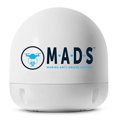
M.A.D.S detects and identifies commercial drones within a 5+ kilometer range, providing GPS positioning of both drone and pilot together with the drone’s speed and heading. Once a drone threat is established, the system enables a 500-meter electronic exclusion zone to be created around the yacht. Should the drone approach this exclusion zone, its control/video signal is blocked, initiating a fail-safe mode and forcing a landing or return to operator.
Operates on the Wave Relay mobile ad hoc network (MANET)
The Auto-Tracking Antenna System is a portable ground-to-air antenna for tracking aircraft, including drones. Defense customers can use it for better airborne communications relay and full-motion video camera/sensor data transmission. It can be assembled and deployed in less than 15 minutes.
Version 6 of Virtual Surveyor drone surveying software offers a faster, more efficient workflow and better user experience in a more stable platform than previous versions. Along with new capabilities is an improved licensing system and an extended free application. The software generates an interactive onscreen environment through orthophotos and digital surface models generated from a UAV, where the surveyor selects survey points and breaklines to define the topography. It enables land surveyors to complement traditional fieldwork with UAV imagery to generate highly accurate topographic products.
Foresights is a risk management and geospatial analytics platform designed to help clients manage forestry assets quickly, effectively and accurately. Foresights identifies areas of new or potential risk, and delivers operations tracking and forest damage management services. It combines satellite imagery, topography maps, soil maps, meteorological data and near real-time ground input from operational teams to deliver optimized insights. It can detect damage as small as 0.1 hectare (0.25 acre) from pests, disease and drought.
EOS Platform provides a powerful toolset for geospatial analysts — offering search, analysis, storing and visualization of large amounts of geospatial data. Image data obtained from LandViewer or uploaded from a user’s computer is stored in cloud-based EOS Storage and is instantly available for remote-sensing analysis or image processing. EOS Processing offers 16 workflows that run online, including raster tools, remote sensing analytics, photogrammetry and proprietary feature extraction algorithms designed by EOS engineers and data scientists to address the main challenges of agriculture, forestry, oil, gas, retail, city planning, defense and other industries.
The Esri book GIS for Surface Water: Using the National Hydrography Dataset by Jeff Simley details how to use geographic information system (GIS) technology to visualize and analyze data sets. Simley is an award-winning cartographer and the former lead of the hydrography program at the United States Geological Survey (USGS). The book examines the complexities of surface water systems and shows readers how to use the Esri ArcGIS software with government water data sets to better study and manage the United States’ vast water system.
EOMAP has opened a commercial online store for global shallow-water bathymetry derived from satellite data. At the store, EOStore Bathymetry, customers can search for and request high-quality data. Satellite-derived bathymetry (SDB) is a valuable tool for the surveying, planning and management of coastal and offshore sites. SDB can provide shallow-water bathymetric data worldwide without the need for a physical presence in the area of interest. EOMAP developed the bathymetry store in response to industry feedback. EOStore Bathymetry offers different horizontal spatial resolutions of the bathymetric grid of 2 to 15 meters, making the data suitable for surveying as well as planning and modeling purposes.
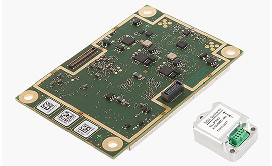
GNSS receiver manufacturer Septentrio has added the AsteRx-i S to its GNSS/INS product portfolio.
The AsteRx-i S combines Septentrio’s compact, multi-frequency multi-constellation GNSS engine with an ultralight external industrial-grade MEMS-based inertial measurement unit (IMU).
Designed around demanding requirements for size, weight, power consumption and temperature variation, the AsteRx-i S is designed for various applications such as inspections with UAVs, UAS photogrammetry, automation, robotics and logistics.
Calibrated for wide temperature ranges, the AsteRx-i S delivers accurate and reliable GNSS/IMU integrated positioning to the centimeter-level, as well as full attitude at high update rates and low latency, the company said.
Key benefits for users include:
GNSS/INS positioning with 3D attitude: heading pitch and roll
AIM+ interference monitoring and mitigation system
High-update rate, low-latency positioning and attitude
Small and ultralight IMU (10 grams)
Robust calibration for wide temperature ranges
“We are delighted to broaden our AsteRx-i GNSS/INS solutions range, bringing maximum flexibility and choice to our customers,” said Francesca Clemente, product manager at Septentrio. “Whether for direct georeferencing in mapping applications with UAVs, for managing containers in a port or for innovative small robots in agriculture, the compactness, affordability and robustness of the AsteRx-i range allows our customers to focus on their success.”
Skyworks has unveiled two new GNSS low-noise amplifier (LNA) front-end modules. The SKY65933-11 and SKY65943-11 both integrate Skyworks’ proprietary TC-SAW filters.
The modules are designed specifically for internet of things (IoT) applications including smartwatches, action cameras, drones, asset trackers and personal navigation devices. athey are designed for wireless module and IoT device manufacturers, providing a turnkey GNSS connectivity solution in a compact form factor.
Both solutions offer:
integrated pre- and post-filter, LNA and matching to reduce PCB area versus a discrete implementation
single DC supply for design flexibility and simplicity
multi-GNSS compatibility to cover GPS, GLONASS, GALILEO, COMPASS (BeiDou) and QZSS receiver applications in the 1559-1606 MHz frequency range
extremely low leakage current (1 uA max) benefitting battery-powered IoT devices
highly manufacturable and low-cost surface-mount technology (SMT) in a 2.5 x 2.5 mm multi-chip module (MCM) package.
SKY65933-11:
Fully integrates all functional blocks, no external components required
Supply range: 1.5 to 2.85 V
Package: 16L 2.5 x 2.5 mm
SKY65943-11:
Exceptional out-of-band rejection and P1dB compression point
Laser Technology Inc. (LTI), manufacturer of professional-grade laser rangefinders, has released its improved TruPulse 360 laser, which features LTI’s TruVector 360° Compass Technology.
The rangefinder has numerous measurement capabilities. According to the company, it can measure slope distance, inclination and azimuth; instantly calculate horizontal and vertical distances; and calculate 3D missing line values.
The enhanced device offers 33 percent increased distance accuracy, 25 percent better target acquisition and a higher azimuth accuracy of 0.5° root mean squared (RMS).
“Given its limitless angle and tilt capabilities, the TruPulse 360 is extremely popular for GPS/GNSS offset mapping processes,” said Eric Miller, president of Laser Technology Inc. “The laser’s flexibility enables users to record offsets and attribute data of multiple features from a single location, making data collection quicker, easier and even safer in potentially hazardous situations.”
The new TruPulse 360 continues LTI’s mission of providing cutting-edge laser measurement solutions in an easy-to-use way, and this model represents an accumulation of more than a decade of work.
In 2007, the TruPulse 360 integrated LTI’s exclusive TruVector 360° Compass Technology, which was developed from the company’s stand-alone MapStar compass module. The combination of an integrated compass, inclinometer and distance laser gave measurement professionals the best possible azimuth accuracy — and mapping-grade precision — no matter the angle it was shot in, the company said.
Features
Photo: LTI
This latest version of the TruPulse 360, with an even more accurate electronic compass integrated into the laser, continues to deliver added value for the modern measurement professional. Uses include forestry, utilities, construction and GIS mapping.
In addition to its increased range and azimuth accuracy and Bluetooth-enabled communication, the TruPulse 360 features:
Reflectorless technology that enables data capture to any surface type;
advanced targeting modes to achieve accurate, repeatable results of the intended target;
seven-power superior optics technology that displays all measured and calculated solutions; and
Smart technology that recognizes adverse measurement conditions and prompts recalibration.
“By integrating our great compass technology into this already groundbreaking device, no other laser on the market can match the performance of the TruPulse 360,” Miller said. “And with our continuous commitment to making user-driven enhancements, the TruPulse 360 stands on its own as the best measurement and mapping laser rangefinder out there.”
Gladiator Technologies has introduced a three-axis, inertial rate system gyroscope. The G300D gyro is 0.67 cubic inches, low power and high speed, making it suitable for image stabilization applications, the company said.
The G300D has message timing under 150 microseconds and output data rates up to 8 kHz with external sync. A micro-electro-mechanical gyroscope, it has an ARW of <0.0028 degrees/sec/√Hz and an option for both 24 and 32-Bit LSB for exceptional resolution.
Users can configure the G300D to their desired configuration using a software development kit or through software protocols to simplify the integration process.
“The G300D, with a 250-Hz bandwidth, allows user to replace more complicated and expensive gyros for image stabilization applications,” said Rand Hulsing, chief scientist at Gladiator Technologies. “The three-axis package is also convenient for mounting in any orientation for tight space requirements.”
“The G300D product is a good example of our SX-series architecture, which has enabled Gladiator to extend our sensor fusion technologies into high speed applications with message latency under 150 usec,” said Lee Dunbar, chief software architect at Gladiator Technologies. “This output offers minimal phase lag like an analog sensor by virtually eliminating typical signal processing and digital conversion overheads.”
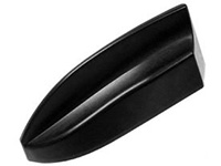
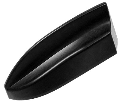
Airgain Inc. has released its Multimax FV 6-in-1 and 5-in-1 antennas.
The compact Multimax FV family is available in a range of configurations, supporting multi-constellation GNSS. The antennas also support up to dual MIMO LTE (including Band 14 for the FirstNet public safety network), 3×3 MIMO Wi-Fi or 2×2 MIMO Wi-Fi.
Airgain is a provider of advanced antenna technologies used to enable high-performance wireless networking across a broad range of devices and markets, including connected home, enterprise, automotive and internet of things.
With a small footprint and a strong, bolt-mount aluminum base, the Multimax FV family provides protection against natural hazards threatening vehicles, including vibration, ice, salt, car washes and tree sweeps.
In addition, the elegant shark-fin design allows fleet owners to add style to their vehicles without compromising performance.
The new products include high-gain antennas that deliver a larger cellular footprint alongside high rejection GNSS technology with coverage for multiple satellite systems including GPS, GLONASS, Galileo and BeiDou.
“Not only does reliable connectivity matter to fleet owners, but also aesthetics and the antenna form factor,” said Reed Pangborn, Airgain’s vice president of Channel Sales for North America. “Our new Multimax FV family is uniquely designed to deliver in each of these key areas. Owners can rely on our commitment to providing class-leading performance across cellular, Wi-Fi and GNSS as well as our industry-best reliability, but all built into a new, sleeker design that complements today’s fleet vehicles.”
The Multimax FV family of antennas can be ordered in either black or white and are available now.
EOMAP has released a commercial online store for global shallow-water bathymetry derived from satellite data. The store, EOStore Bathymetry, provides access to search for and request high-quality data.
According to EOMAP, satellite-derived bathymetry (SDB) is now established as a valuable tool for the surveying, planning and management of coastal and offshore sites. SDB can provide shallow-water bathymetric data worldwide without the need for a physical presence in the area of interest.
“The EOStore Bathymetry allows every coastal engineer, modeller or surveyor to rapidly access up-to-date shallow water bathymetric data,” said Knut Hartmann, COO of EOMAP. “It enables you to get the bathymetry data you need — even data you could otherwise not get — so you can plan and execute projects accurately, effectively lowering the project risk level.”
EOMAP developed the bathymetry store in response to industry feedback, the company said.
“The demand for bathymetry data in shallow waters is increasing significantly,” Hartmann said. “What industry told us at our first conference on satellite-derived bathymetry, in June 2018, was that they needed to understand the global feasibility of SDB methods and ways to search for and request the data. Thus, we’ve created the EOStore Bathymetry, which allows users to get worldwide shallow-water bathymetry data quickly and easily at a fraction of the price of traditional surveys.”
According to EOMAP, EOStore Bathymetry offers different horizontal spatial resolutions of the bathymetric grid of 2 to 15 meters. This makes it flexible and fit for purpose for surveying, as well as for but also for planning and modeling purposes, the company added.
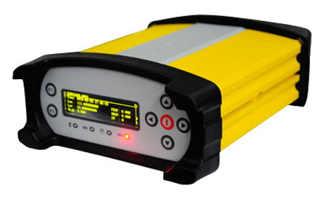
Geneq Inc. has introduced the Net20 Pro, a robust system designed for Continuously Operating Reference Station networks.
The Net20 Pro’s efficiency and flexibility will provide high-quality data for users interested in the proximity and reliability of a reference station while eliminating real-time kinematic (RTK) corrections service charges, the company said.
The Net20 Pro uses multi-frequency, 555-channel technologies in a rugged casing to deliver accurate and effective positioning data even in a harsh environment.
The receiver can be configured for correction data reception in client mode to calculate a fixed RTK position and to monitor the antenna position while continuing to work as a GNSS reference server.
With its NTRIP Caster software, the Net20 Pro provides superior connectivity with an unlimited number of mount points, Geneq said. Users can have permanent transmission of RTK corrections with a simple local internet connection from a LAN working network.
Equipped with an internal memory of 32 GB with an additional 32 GB external memory, the Net20 Pro provides enough storage space for permanent recording even for a 100-Hz high data sampling rate.
The Net20 Pro comes with an ergonomic and easy-to-manage web user interface that features software upgrade, status and settings management, as well as data downloading via smartphone, tablet or other internet-enabled electronic devices.
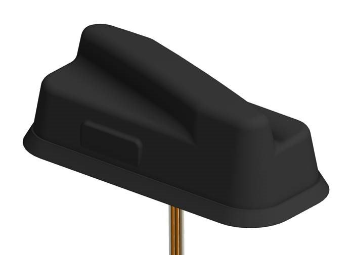
PCTEL Inc. has announced the next generation of its Trooper antenna, the company’s flagship multi-band platform for public safety fleets.
The new Trooper II provides optimal wireless communications performance through the antenna’s 4-port 4G LTE connections and 4×4 802.11ac Wi-Fi MIMO capability, the company said. It also incorporates PCTEL’s newest high rejection multi-GNSS technology for high precision tracking and asset management.
The Trooper II antenna. (Photo: PCTEL)
“The Trooper II antenna enhances PCTEL’s successful Trooper platform, with expanded multi-band RF and GNSS capability in a robust, aerodynamic housing,” said Rishi Bharadwaj, senior vice president and general manager of PCTEL’s Connected Solutions group. “Its slender new design with a single cable exit accommodates installation restrictions often encountered on modern public safety vehicles.”
“Our Trooper antennas have been broadly deployed on public safety fleets, notably in support of the leading FirstNet public safety broadband network systems. The Trooper II is also ideal for many Industrial IoT deployments,” Bharadwaj added.
The rugged Trooper II (part #GL9X1AX-TRB) features PCTEL’s new proprietary high rejection multi-band technology, which supports GPS L1, GLONASS and Galileo for high precision tracking.
In addition to public safety applications, the antenna is suitable for tracking and communications support for industrial internet of things (IoT) and other fleet management applications, including farming tractors for precision agriculture, utility service fleets and railway positive train control systems.
PCTEL will display the Trooper II antenna Aug. 6-7 at APCO 2018, Booth 1719, along with its portfolio of antennas for the public safety industry and grid testing solution for in-building public safety networks.
The Trooper II antenna is available for pre-order now. First shipments are expected in early fall.