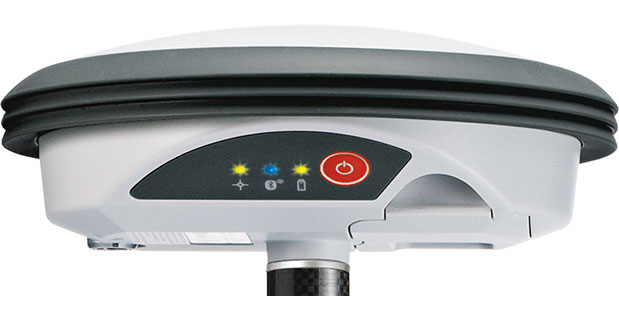
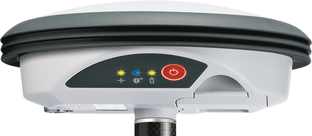
With its recent Ingress Protection (IP) certification, the Leica Zeno GG03 SmartAntenna is now an IP68-certified SmartAntenna for GIS applications. IP68 represents the top rating for protection against dust, moisture and water. Meeting the tough standards for Ingress Protection (IP) makes the Leica Zeno GG03 a rugged GNSS SmartAntenna for GIS asset collection and management tasks.
The upgradable Leica Zeno GG03 SmartAntenna is designed for organizations that require a compact and lightweight device for accurate and reliable positioning. The robust design of the Zeno GG03 brings further advantages when collecting GIS assets by offering reliable and rugged operation in extreme environments, even after continued exposure to water and dust.
“The Leica Zeno GIS series is used all over the world in the most demanding environments,” said Product Manager Johannes Hotz. “The IP68 rating further underlines the quality and robustness of the Leica Zeno GG03. The industry-leading GNSS performance and an unmatched ultra-rugged design is a big win for our customers in the field.”
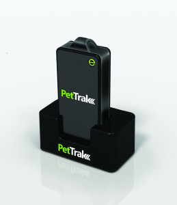
eTrak has announced the release of its latest product, the PetTrak GPS+ tracking system. Now available for purchase online, PetTrak is a small, lightweight device used to track the location of most pets.
PetTrak uses GPS+, eTrak’s patent-pending technology utilizing Wi-Fi, Cell ID, and GPS to deliver accurate location, indoors or out. Users will be able to utilize PetTrak to always know the location of their animal companions. PetTrak also allows users to set up specific safety circle zones, around designated areas where pets spend most of their time. If the pet leaves or enters this zone, the pet’s owner will be notified via text or email.
“One of the best features of PetTrak is the safety circle, which enables pet owners to draw a boundary circle around the house, yard, or any place that provides a protective perimeter for a pet,” said John Harris, eTrak founder and CEO. “If a pet wanders off beyond the circle, PetTrak will send an email and text message to the owner’s cellphone and computer. Not only that, but it will even include a Google map with the pet’s location.”
The PetTrak device can be attached to Simply attached to a pet’s collar. The animal can then be tracked in virtually any environment around the clock, from any smartphone, computer or tablet. With more than six million pets lost every year, PetTrak is designed to help owners rest assured knowing their furry friends are safe.
Millennial Media has announced the launch of Omni Measurement Solutions, a suite of measurement products designed to evaluate and demonstrate the effectiveness of mobile campaigns. The new solutions will combine Millennial Media’s extensive first-party data with best-in-class third-party data sources to show the impact on key advertiser metrics driven by a campaign.
“Measurement is one of the most important issues in mobile advertising today,” said Mollie Spilman of Millennial Media. “Brands need to feel confident that the dollars they are spending in mobile advertising are truly moving the needle, and our Omni Measurement Solutions represent the most comprehensive, data rich solution at this scale in mobile advertising.”
Omni Measurement Solutions currently consists of the following products:
Door Open Rate – Measures the impact on foot traffic to a given retail location generated by a mobile campaign.
Register Ring Rate –Measures the impact in total credit card spend at a retail location due to a mobile campaign, including number of transactions per purchaser and total basket size.
Brand Lift Rate – Measures the impact on high funnel activities such as awareness, intent, consideration, and recall.
For every measurement product in the Omni Measurement Solutions suite, Millennial Media partners with a third party, and matches mobile IDs against exposed and control groups to judge the effectiveness of marketing campaigns with target audiences. Data analytics company Neustar and location analytics firm Placed are among the launch partners. Millennial Media will offer end-of-campaign reports that will accurately show the impact on advertiser KPIs, and give advertisers credible and qualified insights to use for future marketing efforts.
To power Door Open Rate, Millennial Media selected Placed. “The product we’re working on with Millennial Media allows advertisers to track conversions beyond the mobile device itself, and extend measurement into the physical world,” said David Shim of Placed. “By combining Placed Attribution with Millennial Media’s industry leading scale, we’re able to measure the impact on in-store visits in a way that was simply not possible before.”
Additional products will be added to the suite in the coming weeks, including a product in collaboration with comScore that measures online consumer behavior after mobile ad exposure.
Placecast has launched PlaceAd to enable media buyers to target and reach mobile audiences based on their location. In addition to location, advertisers can target and optimize messaging across criteria including age, gender, interests, device type and operating system, time of day, and weather.
PlaceAd is a demand-side platform (DSP) built to maximize the value of location-based inventory on mobile. PlaceAd’s programmatic buying tools, analytics and included dynamic rich media engine are optimized for location-based campaigns. Placecast’s decision engine automatically optimizes campaign performance. PlaceAd can manage geotargeted campaigns based on the quality of the location data across billions of impressions with integrated reporting and store-level analytics.
Placecast is also announcing partnerships with some of the largest ad exchanges and supply side platforms (SSPs), including MoPub, PubMatic, and Smaato. With these key partnerships in place, Placecast can provide substantial reach for brands across thousands of mobile publishers and billions of monthly impressions.
“Mobile advertising, location and real-time bidding are the key ways to reach consumers today, and ad agencies can’t get enough of them,” says Karsten Weide of IDC. “PlaceAd is hitting a sweet-spot in the advertiser market and provides a timely solution for the pain points in reaching mobile audiences locally.”
Besides access to many different sources of ad inventory, media buyers also get comprehensive location-based reporting down to the most granular level, including heatmaps that provide a visual illustration of the intensity of impressions and engagement by targeted locations.
Key features of PlaceAd include:
Reach across thousands of safe mobile publishers for location-based mobile display inventory: Via partnerships with MoPub, PubMatic, and Smaato
Transparency on publishers where campaigns run
Real-time bidding: The ability to price and deliver on a per-impression basis in real-time; IAB OpenRTB 2.1 spec compliant
Machine Learning and Optimization: Placecast’s decision engine optimizes campaign performance based on activity across placements and publishers to maximize performance.
Dynamic Creative: Clients can change elements in the ad based on location, time of day, or other info on the consumer
Store-level analytics and reporting: Consolidated campaign reporting shows deliveries, clicks, and other actions across different inventory down to the individual store location. Heatmaps can be used to see campaign activity near targeted areas.
Geotargeting using both proximity geofencing and metro-level data.
Audience targeting though a number of methods:
Contextual targeting based on content
Place profiles
Third-party audience data
Third-Party Ad Serving Support: Agencies can track their campaign data in DoubleClick for Advertisers or Atlas
“PlaceAd is the latest addition in our toolset that makes it easier for advertisers and agencies to buy location-based mobile campaigns,” said Alistair Goodman of Placecast. “This new offering combines years of geofence marketing expertise with great tools and analytics that together reduce the friction in buying location-based mobile advertising campaigns at scale.”
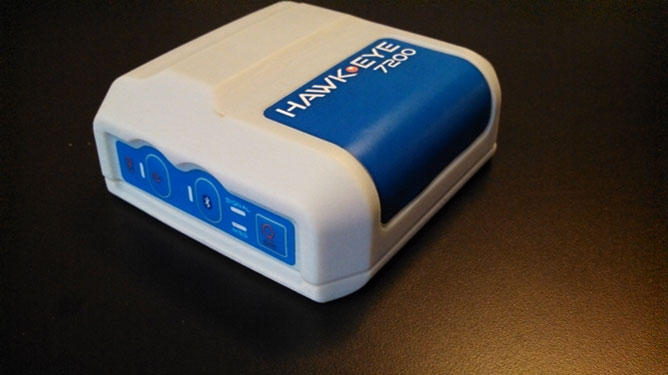
Blue Sky Network’s HawkEye 7200 Portable M2M Tracking Solution.
Blue Sky Network, a supplier of satellite tracking and communication solutions for aviation, land and marine, has launched the HawkEye 7200 portable M2M tracking solution. The HawkEye 7200 includes features such as multinational GNSS receiver support and integrated Bluetooth for Iridium connectivity to smart devices. Designed in a small form factor, the HawkEye 7200 can be powered by battery or via an external power source and is a key addition to Blue Sky Network’s solutions portfolio extending the reach of smart device communications globally anywhere in the world.
The HawkEye 7200 is Blue Sky Network’s first product to incorporate a multinational GNSS receiver. It combines the major GNSS providers into a single location-based chip that can be used in other parts of the world including GLONASS for Russia and the Galileo for the European Union. This multinational GNSS receiver feature enables fleet operators with globally dispersed assets to obtain position reports with increased accuracy and performance. When used with New SkyRouter, Blue Sky Network’s cloud-based web-portal, the HawkEye 7200 offers portable tracking and resource management of any asset type across the globe. The HawkEye 7200 hosts an RS232 interface and digital inputs/outputs for connectivity and control of external sensors or other telematics devices.
With the integrated Bluetooth connectivity, the HawkEye 7200 supports Blue Sky Network’s new iPhone/iPad application. The application allows users to send emails, short-code messages and customizable electronic forms through the Iridium network. With the ability for operators to build and fully customize forms — such as flight plans, maintenance records and logistic records of remote assets — HawkEye 7200 supports the industry’s movement toward paperless fleet operations.
“Blue Sky Network is a long-time member of the Iridium partner ecosystem and is continuously delivering cutting-edge M2M communication solutions targeting new markets,” said Bryan Hartin, executive vice president, commercial sales and marketing of Iridium. “The HawkEye 7200 is yet another solution from Blue Sky Network that offers powerful capabilities and applications that utilize the Iridium network. Together we are providing customers with critical connectivity worldwide.”
“The HawkEye 7200 further bolsters our leadership position in the mobile resource management and tracking industry,” said Blue Sky Network’s CEO and founder, Jon Gilbert. “Combining our HawkEye 7200 with our iPhone/iPad application and our industry-leading backend web portal, New SkyRouter, our customers have a complete end-to-end solution to link the far reaches of the world right in the palm of their hand. We are shrinking the global communication barrier and improving the methods by which people anywhere make connections to manage critical assets and communicate.”
Blue Sky Network is showcasing the HawkEye 7200 at the Helitech International Helicopter Expo & Conference, in London on September 24-26, in booth #B59.
The new HawkEye 7200 is in process of being certified by Iridium, with production expected in Q4 2013.
Kongsberg Seatex has given users of the eBird System the ability to equip SmartWing instrumentation with two additional features — a compass and a GNSS receiver. eBird is a bird concept for lateral, vertical and roll streamer control in marine seismic acquisition that enables fault tolerant and efficient multi-streamer steering by employing a wide range of innovative and patented technological solutions.
The innovative approach of placing a GNSS receiver in the wings opens new opportunities for improving the efficiency of an operation – in particular during launch and recovery but also when running lines.
The built-in GNSS receiver has been implemented based on Kongsberg Seatex’ extensive competence within GNSS technology. Transmission of satellite data from the seismic vessel to eBird reduces the time to first position fix considerably – giving eBird a position with one wing semi-surfaced. The built-in compass has been developed based on Kongsberg Seatex’ deep knowledge and experience within sensor technology and is fully integrated with SmartWing. The compass provides heading information from a submerged eBird.
These add-ons represent further improvements to the eBird streamer positioning and control concept.
“We always try to find improvements to our solutions and these new features are excellent examples of how we combine our core technology and expertise to create improved value for our customers,” says Gard Ueland, President of Kongsberg Seatex AS. “This is one step further in our offering to the seismic market, and we will continue to improve our solutions in close cooperation with our customers.”
eBird has, since its introduction at SEG in 2009, gained high attention within the seismic acquisition community with its sleek and functional design and utilisation of innovative technology together with proven performance in large seismic streamer spreads.
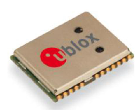
The NEO-7P sub-meter GPS positioning module with Precise Point Positioning (PPP) and Differential GPS.
Swiss-based u‑blox has introduced the NEO-7P, an improved, low-power, compact, high-precision GPS module. While remaining backwards compatible with its predecessor NEO-6P, the new module achieves standalone sub-meter precision based on single-frequency precise point positioning (PPP) technology.
Fully autonomous sub-meter performance can be realized for most outdoor applications within coverage of Satellite Based Augmentation Systems (SBAS) throughout North America (WAAS), Europe (EGNOS), and Japan (MSAS).
In areas where SBAS is unavailable, the NEO-7P achieves high-accuracy based on Differential GPS (DGPS) positioning as an alternative to PPP. DGPS uses RTCM correction messages (correctional data defined by the Radio Technical Commission for Maritime Services) from a local reference station or aiding network to cancel out measurement error introduced by atmospheric distortion and variances in satellite orbits and clocks.
“The NEO-7P addresses many requirements for precise positioning used in surveying, mapping, marine, and clear-sky recreational applications,” said Thomas Nigg, VP product marketing at u-blox. “The solution delivers sub-meter positioning performance based on two techniques at a fraction of the cost of other high precision solutions. The solution is compact, requires no external base station, and uses a single frequency receiver.”
The device comes in u-blox’ compact NEO Leadless Chip Carrier (LCC) module form factor. A UART, USB and I2C interface provide flexible connections to a host processor. It can also communicate directly with u‑blox’ SARA 2G, LISA 3G and TOBY LTE cellular modules.
The NEO-7P also provides complete GPS satellite raw data allowing further accuracy improvement based on post processing by an external host. Internal Flash memory allows simple firmware upgrades. The NEO-7P also supports Russian GLONASS Japanese QZSS positioning standards.
The module is suitable for vehicle, industrial and consumer applications.
Detailed information about the NEO-7P can be found on the u-blox website.
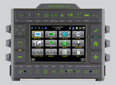
JAVAD GNSS has launched a new version of the TRIUMPH GNSS receiver, which features 864 channels — more than any receiver it has yet offered. The TRIUMPH-LS land survey receiver offers, in addition to the 864 GNSS channels, three powerful processors, 256 I/O, 24 digital filters, 24 anti-jam filters and 14-MB program memory all in a single chip, which uses less power and makes the total system less expensive, according to the company.
The announcement was made at the ION GNSS+ Conference, being held this week in Nashville, Tennessee.
Javad Ashjaee, CEO and founder, explained the decision to incorporate 864 channels. “Some questioned the need for the 216 channels. They now realize the need for 440 channels. We assign multiple channels to each satellite for redundancy and reliability. We use more than 100 channels to scan GNSS bands for interference — 864 channels is the key to reliable performance.”
The TRIUMPH-LS provides visual stake-out, six parallel RTK engines, more than 3,000 coordinate conversions, advanced coordinate geometry features, and rich attribute tagging on a high-resolution 800 x 480 pixel display. When used in photogrammetry, offsets can be calculated using the internal camera for 10-centimeter accuracy, or an external camera for 5-centimenter accuracy. TRIUMPH-LS is the first JAVAD GNSS receiver to offer photogrammetry for land survey.
Other features include versatile attribute tagging, feature coding, automatic photo and voice documentation, and an interference monitoring and reporting feature.
The TRIUMPH-LS has a battery life of 25 hours in RTK rover mode with full screen brightness and UHF/GSM. Two hours of charge equals two days of surveying. The internal batteries are field serviceable and can be easily replaced by the user when needed.
The TRIUMPH-LS, including batteries and pole, is the lightest GNSS RTK receiver in its class, according to JAVAD GNSS. The total weight of the system — including radio, controller, pole and 25 hours of internal battery — is 2.5 kilograms.
Built on a tough magnesium alloy chassis, all connectors, SIM cards, and micro-SD cards are protected against harsh environmental conditions. The pole can be collapsed and the unit can easily fit in a car seat — there are no long poles and no separate controller or brackets to disassemble.
The TRIUMPH-LS automatically updates all firmware when connected to the Internet via Wi-Fi. The built-in GNSS full tracking antenna has a large ground place and excellent centering and rotational performance.
To learn more about the TRIUMPH-LS, stop by the JAVAD GNSS booth (Booth D) in the ION GNSS+ Exhibit Hall now through Friday.Presentation will be given Thursday at the conference room of the exhibition hall at 2:00 pm.
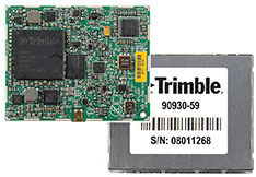
Trimble today introduced the Trimble BD930 module as part of its GNSS OEM portfolio. This small module features triple-frequency support for GPS and GLONASS plus dual-frequency support for BeiDou and Galileo constellations. Capable of receiving a wide range of commercially available GNSS signals, the 220-channel BD930 takes advantage of all available signals to provide optimal and reliable RTK centimeter positioning.
The announcement was made today at ION GNSS 2013 Conference and Exhibition.
“The OEM and system integrator communities trust Trimble to supply high performance, accurate and reliability positioning solutions for their systems,” said Ed Norse, portfolio manager of Trimble’s GNSS OEM modules. “The Trimble BD930 delivers the latest GNSS technology in an easy-to-integrate form factor for demanding conditions and applications such as high-precision navigation and control, robotics and lightweight unmanned vehicles.”
The triple-frequency Trimble BD930 (measuring 41 x 51 millmeters) is a small, yet powerful GNSS module specifically designed for applications requiring high accuracy in a compact package. Form-Fit-Function compatible with the Trimble BD920 receiver, the module tracks all available GNSS constellations including GPS, GLONASS, Galileo and BeiDou.
The BD930 is designed for all levels of accuracy with an advanced engine that provides GNSS, DGNSS and RTK positioning in challenging environments such as under tree canopy and urban canyons. The BD930 allows for easy integration and rugged dependability. Flexible connectivity options — Ethernet, RS232 or USB — provide fast data transfer and easy configuration via standard Web browsers. External 10 MHz frequency input is supported for advanced applications.
The Trimble BD930 module is expected to be available in the fourth quarter of 2013 through the Trimble Precision GNSS + Inertial worldwide sales channel.
Rx Networks, Inc., a mobile location technology and services company, today announced a new z-axis determination capability called Zed. This new solution, comprised of a client software library and associated cloud-based data services, is targeted at chipset vendors, device OEMs and application developers seeking to integrate reliable floor-level detection. The announcement came at ION GNSS 2013 in Nashville, Tennessee.
Whether for emergency or consumer applications, the determination of a mobile device’s vertical position while indoors presents unique challenges. Given the environment, even when a GNSS receiver attains a fix, a mobile device cannot reliably use the reported altitude. Beacon-based techniques, such as those derived from Wi-Fi or Bluetooth, remain challenging as they often rely on GNSS-based crowd sourcing or costly venue characterization. The built-in barometric pressure sensors in recent smartphones bring a new ability to estimate altitude, but they have unique and variable characteristics that prevent floor-level accuracy without further assistance.
Rx Networks’ new Zed solution combines accurate geo-reference barometric pressure data (from Custom Weather, a global provider of real-time weather information), automatic device characterization, and pressure crowdsourcing along with existing location services to determine a device’s altitude within 1 to 3 meters.
The Zed solution will be commercially available at the start of 2014 and will be available either on its own, or as an optional feature alongside Rx Networks’ GPStream Assisted-GNSS and XYBRID hybrid location solutions.
For more information a demonstration of Zed, visit Rx Networks booth at ION GNSS+ 2013.
Rx Networks, Inc., a mobile location technology and services company, today announced that it is upgrading its GPStream GRN (Global Reference Network) to include support for the BeiDou and Galileo constellations alongside its GPS and GLONASS assistance services. The upgrade will be completed by the end of this year with commercial service starting in 2014. The announcement came at ION GNSS 2013 in Nashville, Tennessee.
With the official release of the Chinese BeiDou specifications in late 2012 and the rollout plans for Galileo, several semiconductor vendors will soon be introducing chipsets capable of supporting these new GNSS constellations. Multi-constellation devices receiving GNSS assistance data from GPStream GRN will have much greater success in areas where satellite visibility is severely limited, such as urban canyons or indoors, the company said.
GPStream GRN is the foundation on which Rx Networks’ and third-party real-time and predictive Assisted-GNSS products operate, as used by more than 700 million smartphones worldwide. Backed by a 99.999% Service Level Agreement, GPStream GRN is already a proven source of real-time assistance data for most North American mobile operators for their E911 location platforms.
“Our reference network will be the first to commercially support all four constellations,” said Ryan Reilly, Product Manager, “reaffirming our leadership position on Assisted GNSS solutions for the mobile market.”
For more information, visit the Rx Networks booth at ION GNSS+ 2013.
PCTEL, Inc. announced the launch of its next generation multi-band GNSS antennas for global timing and precision tracking applications at the ION GNSS Conference being held this week in Nashville, Tennessee.
The new antennas, which are designed for use with GPS, GLONASS, BeiDou, and Galileo systems, are being showcased along with other PCTEL antennas at the PCTEL booth in the Exhibit Hall, Booth 318/320. All models of the new antennas are available for sale.
Equipment providers for carrier network timing, precision agriculture, and global asset tracking applications need a single antenna solution for global deployment. PCTEL’s new GNSS1-TMG-26N and GPS-LB12GL-MAG antennas address global compatibility issues for two of the industry’s most crucial applications.
For critical timing applications for macro and small cell deployments, PCTEL has developed the GNSS1-TMG-26N antenna. The GNSS1-TMG-26N is a fixed mount network timing antenna covering GPS, GLONASS, Beidou, and Galileo system frequencies in one single unit, making it a true global solution.
PCTEL’s GPS-LB12GL-MAG antenna is designed for precision agriculture.
For global precision navigation applications, PCTEL has developed the GPS-LB12GL-MAG to cover GPS L1, GPS L2, GLONASS, and L-BAND constellations. The GPS-LB12GL-MAG’s multi-band coverage addresses the precision market in the USA as well as differential correction signals needed across Europe and Asia.
“PCTEL will meet the GNSS market requirements for our global customers while maintaining PCTEL’s high standards for quality and performance,” said Jeff Miller, president of PCTEL Connected Solutions. “We understand that our products need global compatibility to support our customers around the world. We are proud to showcase our design excellence in this highly technical area,” added Miller.
 With its recent Ingress Protection (IP) certification, the Leica Zeno GG03 SmartAntenna is now an IP68-certified SmartAntenna for GIS applications. IP68 represents the top rating for protection against dust, moisture and water. Meeting the tough standards for Ingress Protection (IP) makes the Leica Zeno GG03 a rugged GNSS SmartAntenna for GIS asset collection and management tasks.