Tag: product showcase

  • CHC Offers LT400HS GNSS Handheld

    CHC Offers LT400HS GNSS Handheld

    CHC
    The LT400HS GNSS by CHC.

    CHC today announced the availability of the LT400HS, a rugged 120-channel GPS+GLONASS handheld receiver designed to achieve sub-meter SBAS positioning to centimeter accuracy in RTK networks. The LT400HS is designed to be a cost-effective yet powerful GNSS device for survey, construction and GIS professionals.

    The LT400HS is designed for companies that have not yet invested in GNSS technology due to cost or occasional equipment use, such as earth-moving and landscape contractors, real estate developers, construction SMEs, agriculture irrigation companies, and utilities mapping companies.

    “The LT400HS GNSS handheld series is a compact, rugged, accurate and easy-to-use GNSS receiver to perform surveying and precision mapping tasks wherever RTK Network corrections are available,” said George Zhao, CEO of CHC. “The LT400HS offers unrivaled performance, an attractive price point filling the price performance gap that exists in the industry between GIS level collectors and professional RTK rovers such as our recently introduced X+ GNSS Series. ”

    The LT400HS Series features:

    • Professional 120-channel GNSS Engine – L1/L2 GPS + GLONASS supporting RTCM network RTK corrections and industry standard NMEA output.
    • 3.7” daylight readable transflective VGA touch screen.
    • Built-in GSM/GPRS phone with data transmission, Bluetooth and Wi-Fi connectivity.
    • Built-in 5 megapixel autofocus camera to capture assets information.

    It comes bundled with Carlson’s SurvCE software for survey and construction professionals, or DigiTerra Explorer Mobile GIS software  for accurate GIS field data collection and maintenance.

  • iTRAK Integrates Navigation and Wireless GPS Fleet Tracking

    iTRAK Integrates Navigation and Wireless GPS Fleet Tracking

    Photo: iTRAK Corporation

    iTRAK Corporation, a provider of GPS-based wireless fleet tracking, has integrated the patented iTRAK Fleet Executive (iFE) cloud-based software, the iTRAK WebApp software for tablets and smartphones, and iTRAK’s wireless GPS tracking equipment with the Magellan RoadMate Commercial 5190T-LM fleet navigation unit. The combined product will allow remote tracking of vehicles and handsets in the field, while integrating with the Magellan commercial product to provide in-cab navigation voice prompts and terminal text messaging.

    The new product, combined with a heavy duty engine interface, will meet the new and emerging EOBR/ELD standards, while providing customers with the flexibility, efficiency and reduced liability required by today’s professional carriers and heavy duty equipment operators.

    “Magellan is pleased to have iTRAK as a partner integrating the Magellan RoadMate Commercial 5190T-LM in their offer combining navigation, messaging and fleet tracking,” said Mark Perini, associate vice president of Product Marketing for Magellan.

    The combined system provides fleet tracking using iTRAK’s patented iTRAK Fleet Executive (iFE) and iTRAK WebApp to remotely track vehicles and handsets in the field, while integrating with the Magellan RoadMate Commercial 5190T-LM commercial product to provide in-cab voice navigation and terminal messaging through the iFE cloud-based application. Features include:

    • Five-inch WVGA touch screen.
    • Customizable truck routes.
    • The truck road attributes can be turned off, so drivers can use the same navigation device in their personal passenger vehicles.
    • Free lifetime traffic alerts.
    • Multiple stop routing.
    • Hours of service tracking.
    • Optional engine interface: Both OBD-II and J1939 interfaces are supported. Engine data can be transmitted to the office by the iTRAK system.
    • Loud (93-dB) speaker.
    • Messaging to and from the vehicle.
    • Truck-specific POIs such as weigh stations and truck stops.
    • Bluetooth: The navigation device includes Bluetooth capability, to pair with and serve as the speaker for a smartphone.
    • Ability to phase implementation: The system is modular so it can be implemented in stages to help drivers adjust to the new technology

    The combined product will provide affordable and safe fleet tracking, communication and navigation functions for commercial trucking, service vehicles, government, sales fleets and much more.

    For more information contact iTRAK at 719-686-0100, or e-mail [email protected].

  • IFEN and WORK Microwave Offer BeiDou-2 Support, Enhancements for NavX-NCS GNSS Simulators

    IFEN and WORK Microwave Offer BeiDou-2 Support, Enhancements for NavX-NCS GNSS Simulators

    photo: IFEN  and  WORK Microwave.

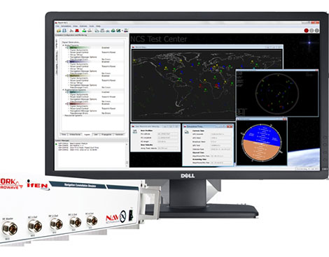
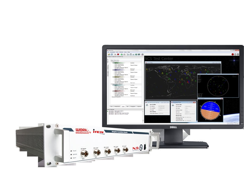
    The NavX-NCS GNSS multi-frequency simulator now supports China’s BeiDou-2 navigation satellite system. BeiDou support is a key enhancement in software update V.1.9 for the NavX-NCS GNSS multi-frequency simulator product line, by IFEN  and  WORK Microwave.

    Leveraging new features and functionalities, users have the flexibility to support a wide range of constellations, frequencies, and channels for research and development of GNSS safety and professional applications, as well as system integration and production testing of mass-market applications, such as automotive satellite navigation, mobile-phone applications, chipsets, and handheld personal navigation devices, the companies said.

    By enabling real-time simulation of second-generation BeiDou satellite signals, also referred to as BeiDou-2, NavX-NCS expands a user’s GNSS signal capability beyond GPS, Galileo, GLONASS, and SBAS constellations.

    “Through a simple software update, NavX-NCS customers can automatically generate signal capabilities for phase two of the BeiDou constellation,” said Dr. Günter Heinrichs, head of customer applications, IFEN GmbH. “Adding BeiDou-2 support to our NavX-NCS simulator comes at the perfect time given the recent release of the BeiDou-2 ICD specification, which outlines interface control requirements for BeiDou-2 B1 satellite signals within the B1 frequency band.”

    A powerful new multi-user functionality enables the simulation of up to four different users, or one user with up to four antennas, in different locations simultaneously, IFEN said. Possible use scenarios include simulating a static user such as a reference station at the same time as a roving user, or simulating multiple docking maneuvers on an oil rig. In addition, the NavX-NCS GNSS simulators now include a new 6DOF functionality that makes it possible to simulate six degrees of freedom (three dimensions of space plus yaw, pitch, and roll). This allows even more true-to-life simulations of ships, airplanes, and cars. A new monitoring widget makes it easier to monitor the current state of simulation.

    Optimized to perform advanced lever arm calculations, the NavX-NCS GNSS simulators ensure accurate navigation for users. In simulation environments where the antenna is not located in the center of the moving object, such as the external of an airplane wing, lever arm calculations compensate for the fact that acceleration and GPS measurements are not made at the same point. By calculating the lever arm measurement between the PAR antenna and GPS position reference for every epoch of observation, this new feature guarantees that the most accurate signal simulation is achieved.

    The NavX-NCS GNSS simulators are available in Professional and Essential versions, both now optionally Export License-Free (LF), speeding up the approval process and delivery time to users abroad. With the Export LF version, users can now limit the simulated user velocity of their simulator equipment to 600 meters per second, eliminating the need for an export license. If an export license should be applied for and be granted later on, it is also upgradeable to a full version meaning the simulation of higher user velocities will be available.

    All NavX-NCS GNSS simulators feature up to nine L-band frequencies and 108 channels, offering users more than twice the number of channels compared with standard GNSS simulators. The platform includes a two-year maintenance contract, the broadest range of frequencies and satellite navigation systems per chassis, as well as the flexibility for users to easily install software updates when they become available.

  • Agency9 Brings 3D Gaming Effects to Web-Based GIS and Planning

    Agency9 CityPlanner, a web service for 3D visualization, has released support for 3D rendering effects such as real time shadow mapping, ambient occlusion, atmospheric scattering and god rays. These effects, traditionally only seen in high-end video games, elevate even the most simple 3D-model and city model to an astounding visually level and enables shadow studies for planners, Agency9 said.

    CityPlanner is a tool for intelligent 3D-GIS visualization with the combination of a powerful 3D engine and support for traditional GIS data sources and standards such as KMZ, WMS, GeoTiff, ESRI Shape and more.

    Agency9 CityPlanner is a web-based service for 3D visualization of projects within urban development, infrastructure and energy. CityPlanner provides 3D web planning tools for widespread access and collaboration. It is created for urban planners, communicators, consultants and GIS technicians to create, share and publish project and spatial information from a normal web browser. CityPlanner is used by municipalities internationally in their daily work with master and local planning, also involving stakeholders and citizens in the planning process by enabling web publishing of 3D plan visualisations.

    “We are very pleased to announce these exciting features that continue to strengthen the position of Agency9 CityPlanner as the premier 3D visualisation tool for the web. CityPlanner is continuously evolving by being developed in close cooperation with the users to ensure that the product supports their workflows and requirements without compromising user experience and usability,” said Johan Göransson, Product manager.

    Atmospheric scattering and god rays:

    Atmospheric scattering and god rays

    Real time shadows & Ambient Occlusion:

    Real time shadows & Ambient Occlusion


  • Juniper Systems Updates Aspect Field Mapping Software to v1.2

    Juniper Systems Updates Aspect Field Mapping Software to v1.2

    Photo: Juniper Systems

    Juniper Systems has released a new version of its field mapping software, Juniper Aspect 1.2. The release builds upon and adds to its previous strengths as an easy-to-use, versatile mapping tool.

    Juniper Aspect is a field mapping software designed to boost efficiency and productivity, while being simple enough that anyone can quickly learn how to use it, according to Juniper. It places the capabilities of GPS and GIS in the hands of field workers, resulting in more streamlined processes, the company said. Used for any job that requires locating, documenting, and inspecting assets, Juniper Aspect is a flexible solution for many different lines of work.

    Juniper Aspect version 1.2 offers improvements designed to boost worker efficiency and user-friendliness. With a new feature to more extensively filter and organize data, and an ability to more easily import large amounts of data into Excel, Juniper Aspect 1.2 offers greater benefits in time-savings and ease of use, the company said. Furthermore, the software appeals to a  broad audience, as it will now operate on most devices running Windows Mobile 6.0 or higher.

    “At Juniper Systems, our focus is on the customer,” said Jim Benson, Public Works Market Manager at Juniper Systems. “And that’s why we have implemented many of the new changes in Juniper Aspect 1.2—to respond to the requests of our users. This new release is amazingly easy to use, and yet it does more to make jobs easier and workflows run smoother.”

    Current Juniper Aspect customers will automatically receive the new upgrade simply by checking for new updates in their current software version. New customers can contact Juniper Systems to learn more about Juniper Aspect 1.2. They can also download a free preview version of Juniper Aspect.

  • Trimble Launches AP15 GNSS-Inertial Board Set for Positioning

    Trimble Launches AP15 GNSS-Inertial Board Set for Positioning

    AP15Trimble introduced today the Trimble AP15, the latest member of the AP series of OEM GNSS-Inertial board sets. The introduction was made at the AUVSI 2013 Conference and Exhibition, being held in Washington, D.C.

    The AP15 uses a custom Micro Electromechanical Machined (MEMS) based Inertial Measurement Unit (IMU). It is the first product to take advantage of Applanix’ proprietary calibration process — Applanix SmartCal, a new software compensation technology that allows Trimble to achieve exceptional performance from IMUs manufactured specifically for mobile mapping applications.

    The AP15 combines high-precision GNSS positioning with Applanix IN-Fusion GNSS-Inertial integration technology, all running on a powerful, dedicated Inertial Engine (IE) board. AP products provide the performance and functionality of Applanix’ POS systems in an embedded form-factor that is specifically designed for third-party manufacturers and systems integrators, Trimble said. The AP Series is designed for a variety of commercial mobile positioning and orientation applications including airborne, terrestrial and marine mapping and guidance for unmanned vehicles.

    Combined with a wheel-mounted Distance Measurement Instrument (DMI), the AP15 provides a full 6-degrees-of-freedom navigation solution for land vehicles that is capable of providing robust position and orientation information regardless of obstructions to GNSS-only positioning such as multipath or complete signal loss. Applanix IN-Fusion technology produces uninterrupted position, roll, pitch and true heading measurements of moving platforms by combining IMU data with raw GNSS observables and DMI velocity.

    GNSS functionality is provided by a Trimble GNSS module, a dual-antenna, 440 channel, multi-frequency survey-grade GNSS receiver that supports a wide range of satellite signals, including GPS L1/L2/L2C/L5 and GLONASS L1/L2 signals. The module also supports Satellite-Based Augmentation Service (SBAS) corrections, including the U.S. Wide Area Augmentation System (WAAS), European Geostationary Overlay Service (EGNOS), Japan’s Multi-functional Satellite Augmentation System (MSAS) and the OmniStar VBS, HP and XP/G2 corrections.

    “Trimble is a leading provider of technology for positioning and orientation solutions and the introduction of the AP15 module continue this tradition,” said Kevin Andrews, product manager. “The AP15 has been designed as a more compact, lighter unit which can deliver excellent performance at lower cost.”

    The Trimble AP15 is expected to be available in October of 2013 through Applanix’ sales channel.


  • Trimble Introduces Ashtech High-Accuracy GNSS Module for System Integrators

    Trimble Introduces Ashtech High-Accuracy GNSS Module for System Integrators

    MB-OneTrimble introduced today the Ashtech MB-One GNSS module. The MB-One delivers highly accurate GNSS-based heading plus pitch or roll in an advanced industry standard form-factor for system integrators.

    The announcement was made today at the AUVSI 2013 Conference and Exhibition.

    Its embedded Z-Blade GNSS technology uses all available GNSS signals equally, without any constellation preference, to deliver fast and stable solutions. The MB-One is designed to add precise positioning and heading in a wide variety of applications such as unmanned, agriculture, marine and military systems.

    “System integrators demand high performance, reliability and support for their positioning solutions,” said Olivier Casabianca, business development manager for the Trimble’s GNSS OEM products. “The MB-One is designed for easy integration and rugged dependability. Users can leverage the module’s Ethernet capability and easy-to-use web browser interface to quickly and cost-effectively develop their products and solutions.”

    The MB-One features an enhanced dual-core GNSS engine with 240 channels capable of tracking a large range of GNSS systems including GPS, GLONASS, Galileo and BeiDou. It uses over-the-air satellite corrections using L-Band hardware to achieve decimeter-level accuracy. The module is capable of receiving and decoding Precise Point Positioning (PPP) to output a highly accurate position solution that removes the need for a local base station.

    The Ashtech MB-One module will be available through the Trimble GNSS OEM international network of representatives and authorized dealers. Evaluation units will be available in the fourth quarter of 2013 and production units are expected to be available in the first quarter of 2014.


  • Bliley Offers Oven-Controlled Crystal Oscillators

    Bliley Offers Oven-Controlled Crystal Oscillators

    Photo: Bliley

    The rugged Poseidon Series of OCXOs by Bliley features unparalleled phase noise performance in a modular type sealed package. It is a customizable frequency range product specifically designed for vibration-prone environments where dynamic phase noise performance is paramount. Applications include ground mobile, airborne, and shipboard environments.

    Features include typical acceleration sensitivity of <2e-11/g, excellent FvT performance, frequency range of 5 MHz to 130 MHz, ultra-low static and dynamic phase noise, and excellent long-term aging.

  • Panasonic Offers Durable Antennas for Wireless

    Panasonic Offers Durable Antennas for Wireless

    The VIC100 Series antenna by Panasonic

    The VIC100 Series antenna by Panasonic is an active L1 GPS antenna designed for timing and synchronization. It offers immunity to noise and interference, and secure performance by attenuating noise and interference near the GPS L1 frequency through triple-filtering design.

    The VIC100 Series is housed in a waterproof enclosure designed for excellent performance under severe environmental conditions. Its shape prevents accumulation of snow and ice, eliminating problems with bird perching and enhanced immunity to lightning surge.

  • Frontline Offers GNSS Emulator

    Frontline Offers GNSS Emulator

    Photo: Frontline Test Equipment Frontline Test Equipment is now offering the Genos GNSS Simulator, a high-dynamic, flexible signal emulator for testing satellite navigation functionality. It is able to emulate satellite signals visible to GNSS receivers for any location around the world, including GPS, Galileo, GLONASS, Beidou, and SBAS (WAAS and EGNOS) signals.

    The simulator helps the user evaluate the performance and characteristics of a GNSS receiver, including time to first fix, acquisition sensitivity, tracking sensitivity, and location accuracy. Also, Genos provides scripting options for creating test configurations that start, stop, raise, and lower attenuation and simulate the various dynamics indicative of cars, airplanes, pedestrians, and other modes of transportation and movement. These customized test configurations can be defined using the Genos user interface or through a script file.

  • Topcon Announces Upgrade to Reference Station Network Software

    Topcon Announces Upgrade to Reference Station Network Software

    Photo: Topcon

    Topcon Positioning Group announces new reference station network software — TopNET+ v10 — bringing new features and functionality to the TopNET+ reference station software suite.

    Topcon’s TopNET+ software is a scalable solution supporting everything from a single CORS station to multiple CORS sites covering a large geographical area. Users of a TopNET+ reference network get GNSS RTK correction data generated using information from all reference stations in a network. This feature allows regional use of RTK while providing data that is specific for each local rover, Topcon said.

    New features available in the latest TopNET+ v10 include:

    • Custom sub-networks based on a rover’s position within a larger regional network, which better supports the network RTK rover to local field conditions;
    • RINEX (Receiver Independent Exchange Format) shop with expanded data management functionality for conversion of data from Topcon and third party reference stations connected to the network;
    • Background maps and BING Maps allow multiple perspectives of the network orientation and regional surroundings;
    • Expanded network RTK engine logging providing detailed metrics of TopNET+ results.

    “This upgrade of TopNET+ software provides increased capabilities and a more visual and detailed presentation of network status to the users of Topcon networks,” said Tom Morris, TPS senior product development manager. “Users will have a customized solution better adapted to local conditions and a better view into the hard processing and statistics being generated in TopNET+.”

  • Chronos Releases Handheld GPS Jamming Detector

    ctl3520-handheldU.K. firm Chronos Technology has released the CTL3520 handheld GPS Jamming Detector and Locator System. Aimed specifically at detecting GPS jammers hidden in vehicles, the unit can pinpoint even the weakest jammer and identify the vehicle in which the jammer is hidden, even in a busy multi-storey car park, Chronos said.  Other applications include detecting vehicles with jammers at ports, fleet depots, airport car parks and taxi ranks.

    The CTL3520 device was recently tested by representatives of law enforcement and security agencies in screened rooms at the MIRA test facility in Warwickshire and successfully identified hidden jammers both in vehicles and people’s pockets.

    The CTL3520 was developed from research undertaken by the University of Bath and is a significant commercial outcome of the Sentinel research project, which was partly funded by the Technology Strategy Board.

    “Previous jamming detecting products have been unable to identify which vehicle is hosting the jammer,” said Charles Curry, founder and managing director of Chronos Technology Ltd. “This has been a particular limitation and a major challenge for people wishing to protect critical infrastructure if faced with GPS jamming emanating from a nearby vehicle. Most websites currently selling GPS jammers maintain that the operating distance of a jammer is just a few meters. This is simply not true. We have tested GPS jammers in controlled trials and their range is easily 250/300 meters which makes specific vehicle identification extremely difficult, particularly in a multi-storey car park. The CTL3520 solves this problem and can pick out one vehicle in a thousand which has the jammer installed.”

    “This product contains advanced technology which is the culmination of more than two-years of research and development at the University of Bath, funded by the Engineering and Physical Sciences Research Council (EPSRC) within the Sentinel project. We are delighted that our collaboration with Chronos has led to a commercial product,” said Robert Watson, University of Bath Electronic & Electrical Engineering Department.

    In addition to UK users, Chronos is seeking international resellers and distributors to take the product into critical infrastructure protection and law enforcement markets where there is a recogniszd concern about the proliferation of low cost GPS jammers used by criminals to cover their tracks or vehicle drivers for personal privacy purposes.