RapidEye, a specialist in high-resolution, wide area repetitive coverage of earth through its constellation of five satellites, announced today that the African Malaria Control Project, MALAREO, which incorporates RapidEye data, has come to a close and results are now available on the project’s website.
MALAREO, which began just over two years ago, was funded by the European Commission under FP7 and run by a mixed European-African comailnsortium, which incorporated years of experience in malaria control, with the Global Monitoring for Environment and Security (GMES) Earth Observation expertise.
Remote Sensing Solutions GmbH (RSS) near Munich was responsible for data processing and the development of EO products for the project, which explored the spatial variability of malaria-relevant environmental factors at local level and supported the work of the National Malaria Control Programs in South Africa, Swaziland and Mozambique. The MALAREO study area, about 43,000 square kilometers, was imaged by the RapidEye satellite constellation, and data was provided via the EC/ESA GMES Space Component Data Access (GSC-DA).
After completion of the project in January, a final meeting with end-users from the Southern African National Malaria Control programs and the MALAREO project team took place in Durban, South Africa, where the products derived from the RapidEye imagery were presented. The end-users emphasized the benefit of these products and the resulting Map Atlas for malaria control, as it greatly improves planning of malaria control measures. It also complements the approach of linking environmental and epidemiological data, which is a first step towards an early warning system for malaria.
The MALAREO Map Atlas, summarizing the EO-based mapping approaches and additional information about the project can be found at the project website.
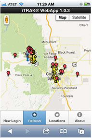
The iTRAK WebApp displays vehicle fleet and landmarks.
iTRAK Corporation, provider of GPS-based tracking, mapping, and reporting solutions, has announced the commercial release of its iTRAK WebApp application. The WebApp provides much of the functionality of the iTRAK Fleet Executive software suite in a mobile environment.
The new application allows iTRAK customers to view all their tracked devices on a wide variety of smartphones and tablets, such as iPhone and Android phones and iPAD tablets. The assets displayed can be tracked using dedicated, in-vehicle GPS devices or GPS-enabled cell phones. Managers and supervisors who regularly work out of the office can still view the location of the vehicles for which they are responsible, as well as historical location and stop data and user-defined landmarks. The mapping system is integrated with Google global street and satellite maps.
iTRAK has been offering mobile fleet management solutions since 2007, when iTRAK FleetFinder, a system to display mobile assets on a Blackberry, was released. The iTRAK WebApp is a response to the convergence of multiple applications on mobile devices, and to customer requests for a mobile fleet management system that will support multiple platforms and operating systems.
The iTRAK WebApp will run on devices that use Apple OS 5.1, 6.0, and 6.1, Android OS 4.0, 4.1, 4.2, and Blackberry 10. Future releases will add geofencing, stored, user-defined map views, and route display. Nine languages are supported: Arabic, Dutch, English, French, German, Italian, Polish, Portuguese and Spanish. There is also an API to the system that allows for third-party integration. Enterprise versions of the cloud services and server software are also available.
iTRAK Corporation (formerly Data Burst Technologies) was founded in 1995 as a developer of GPS-based wireless tracking and AVL systems. The company’s principal offices and network operations center are located in Woodland Park, Colorado.
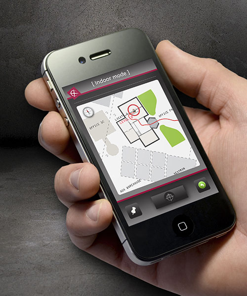
New technology from product development firm Cambridge Consultants can accurately detect someone’s location indoors when GPS drops out. A number of sensors and a custom algorithm determine the location, with an accuracy of within approximately 1 percent of the distance traveled.
The technology uses low-power, low-cost sensors and the device concept is small enough to clip on a belt. It also doesn’t need any existing internal infrastructure.
“We are excited about the many possibilities this cutting-edge technology opens up and the impact it can have in many different situations,” said Geoff Smithson, technology director, sensing systems, at Cambridge Consultants. “It could be used to help locate firefighters in smoke-filled buildings, for example, or to pinpoint the closest doctor in a hospital during an emergency — or to track offenders during home curfews. We are just starting to see the potential of this approach and the diverse demand for this type of low-energy, highly accurate system.”
Indoor tracking systems, which process data from one or more sources of location information to estimate where a person or object is located, are not new. But they often rely on RF signals from Wi-Fi access points or custom infrastructure, poor-quality GPS signals or expensive, high-quality sensors. The availability of low-cost smartphone components — including accelerometers, gyroscopes, magnetometers and pressure sensors — has enabled a new generation of location devices and applications, when combined with a tailored Bayesian algorithm to fuse the information.
The new technology platform can be embedded in an existing design or operate as a stand-alone unit, with options to compute the location locally or transmit the information to a remote system that can process the data before visualizing it on a smartphone app.
“Our biggest challenges were developing an algorithm which optimally combines the data from GPS and the other sensors, and overcoming the issues of using such low-cost sensors in a system without any absolute location reference,” said Smithson.
Cambridge Consultants specializes in developing low-cost, low-power connected devices for clients with a team of experts with sensing, wireless and software engineering expertise. The latest technology builds on the company’s tracking and location systems experience in a variety of market sectors ranging from defense and security to consumer, industrial, and oil and gas.
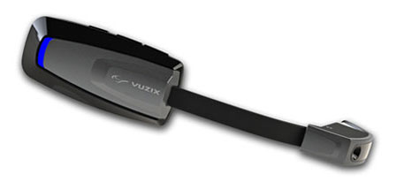
Vuzix Corporation today announced that it has begun shipping M100 Smart Glasses to the first of its Gold developer partners — enabling them to start creating and testing their apps on the real hardware.
The M100 Smart Glasses are a smart hands-free display and communications device for mobile data access, once paired to a smartphone and connected to the Internet. The glasses include an integrated head tracker and GPS for spatial and positional awareness.
Vuzix is a supplier of Video Eyewear products in the consumer, commercial and entertainment markets.
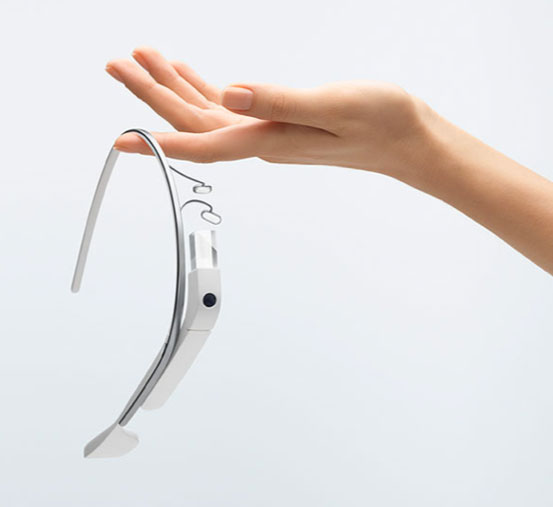
Google Glass
The M100 is in competition — and a race to market — with Google Glass, a similar wearable device. Google recently held a contest to provide sample sets of the glasses to non-developers willing to pay $1,500 — which encouraged Internet and media buzz.
M100 Smart Glasses
Google Glass could be released to the mass market by the end of the year. Google Inc. already sold an unspecified number of the glasses to developers who also paid $1,500 apiece at a company conference in June 2012. The mass-market version of Google Glass is expected to cost less than $1,500, but more than a smartphone.
Like the M100, Google Glass is intended to perform many of the same tasks as smartphones. The glasses include a little display screen attached to a rim above the right eye, run on Google’s Android operating system, and respond to voice commands, which is intended to make it easier for people to take pictures or record video wherever they might be (such as skydiving or riding a rollercoaster). Here is a video showing the glasses in action:
When he demonstrated the glasses at last June’s company conference, Google co-founder Sergey Brin acknowledged the company was still working out bugs and trying to figure out how to extend the product’s battery life.
Privacy Concerns. The ease of taking pictures and recording video with the glasses is causing some to question whether privacy will be affected. zdnet blogger Ben Woods writes, “These glasses can instantly capture and store every move of everyone around the person wearing them. Remember that drunken argument you had with your partner? Well, now Google Glass will mean you have no possibility of forgetting it. If it’s entertaining enough, or you’re well-known enough, the video of that argument could well be on YouTube before you get home. Do you do a lot of business on the phone while out and about or while sitting in coffee shops? Will you continue to, if you know that every call could be recorded by the stranger sitting at the table opposite, staring innocently at the picture on the wall behind your head?”
Google first began developing the glasses in 2010 as part of a secretive company division now known as Google X.
How the M100 is worn.
Vuzix Showstopper. Displayed at Mobile World Congress in February as a “Showstopper,” the M100 contains a near-eye micro display with an integrated camera and powerful processor running an Android OS. It connects wirelessly to a user’s smartphone (iOS or Android) or other compatible device via Bluetooth or Wi-Fi, can connect directly to the Internet, and run applications and games on its own. Working in harmony with a user’s smartphone, the M100 enables access to a vast array of existing and future text, video, GPS, and audio applications, Vuzix said.
With the glasses, users can answer the phone using a visual address book, record video and run applications, including basic augmented reality apps. Interactive tracking and an integrated camera, combined with newly developed applications on the M100 and a wireless link to the Cloud, enable the merging of virtual information with the real world. An integrated camera enables video recording, still image capture and the potential for powerful augmented reality applications.
Industry, Medical. “Although we are seeing applications developed in most every market, there has been a strong focus on the industrial and medical markets,” said Paul J. Travers, chief executive officer.
“Our Company has a focus on developing the fundamental tools that enable applications from training to warehousing,” said Pete Wassell, president of Augmate Corporation, one of the first M100 Gold developers. “This new category of device is going to revolutionize many markets by injecting cloud-connected, hands-free and geospatially accurate information to applications that desperately need it. The M100 does a great job of delivering on that promise.”
The Vuzix developer program offers early access to the M100 smart glasses, technical support and advice. The M100 software developers kit is available in two versions, Gold and Silver. These SDKs are being delivered in stages and include frequent updates, hardware advances when released, and access to the developer center to provide technical and developer community support.
Because the demand is strong, Vuzix is delivering the first smart glasses on a first-come, first-served basis with custom-built prototypes going exclusively to its Gold Developers.
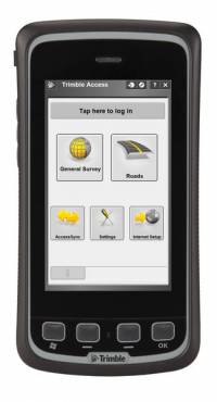
Trimble has introduced an all-in-one device for mobile communications and surveying data collection — the Trimble Slate Controller. The Trimble Slate Controller combines the convenience and ease-of-use of a smartphone with rugged durability. Optimized for Trimble Access field software and the Trimble R4 GNSS receiver, the Trimble Slate Controller supports a surveyor’s everyday workflows.
“Surveyors require mobile, rugged solutions that can readily withstand and perform in the toughest of conditions,” said Erik Arvesen, vice president of Trimble’s Survey Division. “With the introduction of the Trimble Slate Controller, we are providing a rugged handheld device designed to run survey workflows while also delivering the capabilities and convenience of a smartphone.”
Offering voice, SMS text, and 3.75G cellular data transfer capabilities on GSM cellular networks worldwide, the rugged Trimble Slate Controller enables enhanced connectivity in the field. Its wireless communication capabilities keep surveyors connected to the office. An integrated 8-megapixel camera offers enhanced job documentation and point attribution by providing geotagged, high-quality digital photos.
The Trimble Slate Controller’s slim, ergonomic design is easy to hold while its screen provides superior sunlight readability enabling all-day use by survey professionals. Designed to withstand even tough conditions, a 4.3-inch capacitive touch Gorilla glass display covers the entire front surface, increasing readability without sacrificing durability.
Trimble Access field software available on the Trimble Slate Controller offers a variety of features and capabilities to streamline topographic, stakeout, control and other surveying applications. Partnered with Trimble Access and the Trimble R4 GNSS receiver, the Trimble Slate Controller provides a dedicated GNSS solution that is effective for both real time and post-processed GNSS surveys, Trimble said.
GPSTrackIt has released a fleet management tool called Driver, a website that enables drivers using tablet devices such as iPads and Androids to send and receive messages and plan routes.
The site provides drivers with two-way communication by chat or forms with dispatchers and fleet managers. It also provides them with route management and timekeeping utilities. Driver compliments GPSTrackIt’s recent releases for smartphones and tablet apps for dispatchers and fleet managers.
According to Eddie Bermudez, product manager, GPSTrackIt’s vehicle tracking system has been enhanced with Field Service Manager (FSM). “The FSM is the control center for all of the mobile workforce management tools available through the Driver website. Dispatchers and fleet managers use the Field Service Manager to create and send messages. The can build Quick Messages and Quick Responses that drivers can select from a list. They can also create forms with multiple questions, and multiple choice answers that streamline the communications process.”
Dispatchers enter stops and build routes using the FSM. The routes can be rearranged as new stops are added, saving drivers time and reducing the need for them to call in. The routes are pushed out to the drivers, who can then display them on maps and list out the directions. They can also use a third-party navigation app to render true turn-by-turn directions.
Soon Driver will provide route optimization. “Driver will look at all the stops and do the arranging for you,” said Bermudez. “It will evaluate the relative distances and calculate the most efficient route.”
In addition, the FSM also provides a mobile time clock. “This enables drivers to clock in and out using the tablet,” Bermudez said. “That data, as with the chats, stops, and forms, can be reported on using Fleet Manager’s reports. It provides fleet managers with a verification tool for employee timekeeping.”
One of the other advantages to using a tablet device is that it offers users a wide variety of useful mobile apps.
“Tablet devices provide our customers with a platform that not only connects them to the Fleet Manager system, but many other productivity tools,” adds John Stull, President and founder of GPSTrackIt. “Drivers can make use of other apps and peripherals to do credit card transactions, scan and transmit contracts, and perform many other important tasks.”
Spectracom announces its ability to simulate up to 64 RF channels in four frequency bands for testing the integration of most advanced GNSS receivers.
The GSG series of GNSS simulators are designed to offer as much capability as needed by developers, integrators, and manufacturers of applications for global satellite navigation. “We understand the needs for simulating GPS and GNSS signals varies as much as the applications themselves,” said Spectracom CTO John Fischer. “Now the diversity of GNSS signals enables a new generation of receivers requiring a new set of test tools. We designed our simulators to grow along with the GNSS eco-system while maintaining the affordability and ease-of-use that has been our hallmark.”
Spectracom offers two fully configurable and upgradeable platforms. For common single frequency applications, the GSG-5 series simulates up to 16 GPS satellites in the L1 band. Users can start with a single-channel RF generator and upgrade their unit in the field when their needs change. For more advanced applications, the GSG-6 series offers up to 64 channels in four different frequency bands simultaneously. Current firmware generates GPS and GLONASS satellites in L1, L2, L2C, and L5. Customers will receive firmware updates when they need to simulate Galileo and Beidou satellites in the E1/B1, E5/B2, E6/B3 bands.
In addition to generating satellite signals, these GPS and GNSS simulators include other advanced capability in every unit such as simulating satellite-based augmentation systems (SBAS), dynamic motion characteristics (trajectories), multipath, white noise, and interference. Tests can be performed anywhere, anytime, from the convenience of the test bench, Spectracom said.
“Comprehensive testing and validation of high-reliability positioning, navigation and timing applications has been a natural extension of our rich heritage in delivering precision time and frequency products and systems,” said Spectracom CEO Lisa Withers. “As we continue to expand our GNSS signal management offerings, we are excited to introduce synchronization, simulation and test solutions that are geared to be readily adaptable to our customers’ unique applications.”
Fujitsu has revealed a walking cane with built-in GPS. Fujitsu displayed the cane at Mobile World Congress 2013 in Barcelona, Spain, reports engadget. No launch date has been set for the device.
Fujitsu’s GPS cane allows users to set a route and get directions through an LED display in the handle, and follow directions along with a large arrow. If the walker turns the wrong way, the handle vibrates to alert him or her. The cane also allows friends and family to track a user’s location, and send an email alert if the user has fallen down.
The cane include medical monitoring features, with a sensor that monitors the heart rate and skin temperature of the user. This information can be viewed online in real time, giving caregivers peace of mind while allowing the cane user greater independence.
Pole Star has launched its new indoor location platform, NAO Cloud. NAO Cloud simplifies the deployment of indoor location solutions by introducing an automated deployment process that dramatically reduces time-to-market and the costs of indoor location-based services, Pole Star said.
NAO Cloud integrates the NAO Campus Software Deployment Kit (SDK), and enables customers and partners to deploy NAO Campus, Pole Star’s indoor location solution, in just a few hours, by using cloud-based software tools as well as positioning databases already available and shared by worldwide partner program members.
In addition, third parties will have access to NAO Cloud’s crowdsourcing capabilities, eliminating field interventions for a simpler, faster and more affordable deployment and maintenance process, Pole Star said. Behavioral analytics or geofencing are also supported by NAO Cloud to maximize the monetization of value added location-based services.
The NAO Cloud platform targets a wide range of businesses such as venue owners, advertising platform providers, application developers, global solution integrators or network operators. NAO Cloud makes deployment, integration in mobile apps and maintenance of indoor positioning services a simple process, from a single venue to a worldwide multi-site coverage, Pole Star said.
“The indoor location services market has reached maturity. Multi-venue owners, marketing agencies and major telcos understand the challenges and the value of hyper-local information and real-time interactions with customers and related Indoor Location Analytics. Indoor positioning is the core technology that brings high value,” said Christian Carle, CEO of Pole Star. “NAO Cloud is the result of years of innovation and deep market experience through very large and complex field deployments around the world.”
In 2012, Pole Star achieved several major innovation milestones, such as the integration of Bluetooth Low Energy and Inertial Sensors in its NAO Campus fusion engine, in addition to Map Data, Wi-Fi and GPS signals. The dynamic combination of these technologies provides today the best indoor location performance results in the market, while addressing any type of building and minimizing network infrastructure, deployment and maintenance costs, Pole Star said.
The NAO Campus solution is now available for more than 80% of the smartphone market, compliant with Android and iPhone devices and embedded in consumer applications on the Google Play Marketplace and the Apple App Store.
Today, Pole Star’s indoor location solutions have been deployed in more than 43 million square feet, in 15 countries such as airports (Paris Charles de Gaulle), shopping centers in Europe and North-America, museums and department stores. In 2011, Pole Star opened its North American headquarters in Palo Alto and has expanded its international presence in 2012, building deep partnerships with companies in Europe, North-America, Asia, Australia and the Middle East. Finally, at the end of 2012, in time for the holiday season, Pole Star launched, its “living lab” mobile application, Mall Buddy, that covers 9 of the biggest malls in Silicon Valley, from San Francisco to San Jose and demonstrates the worldwide extension capability of Indoor location services.
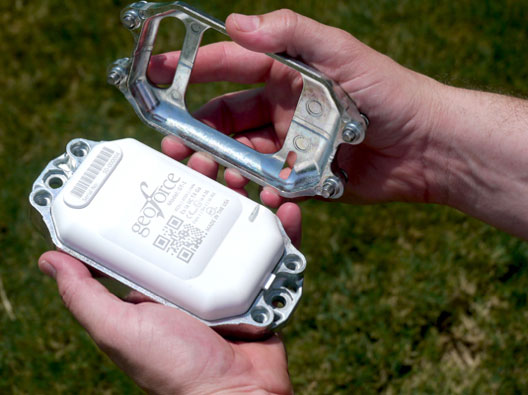
GT-1 asset tracker combines GPS, RFID, and Bluetooth technologies. Photo: Geoforce
Geoforce, Inc. is announcing commercial availability of its GT-1 asset tracking device that can track field equipment in locations and conditions previously too challenging for other devices to function effectively. A globally certified GPS device, the GT-1 enables oil and gas service providers to proactively monitor and share data on vehicles and equipment for more cost effective operations, helping to meet ongoing environmental responsibilities, the company said.
“We have been waiting a long time for a device like this,” said Michael Rolston, operations manager at Permian Equipment Rentals. “It’s small, it’s incredibly rugged, it will last years without replacement. It’s also surprisingly low cost — given all its features and capabilities.”
The GT-1 was previously offered in limited release to several major international service and rental companies beginning in the fourth quarter of 2012. To date, thousands have shipped and are actively tracking oilfield assets around the globe.
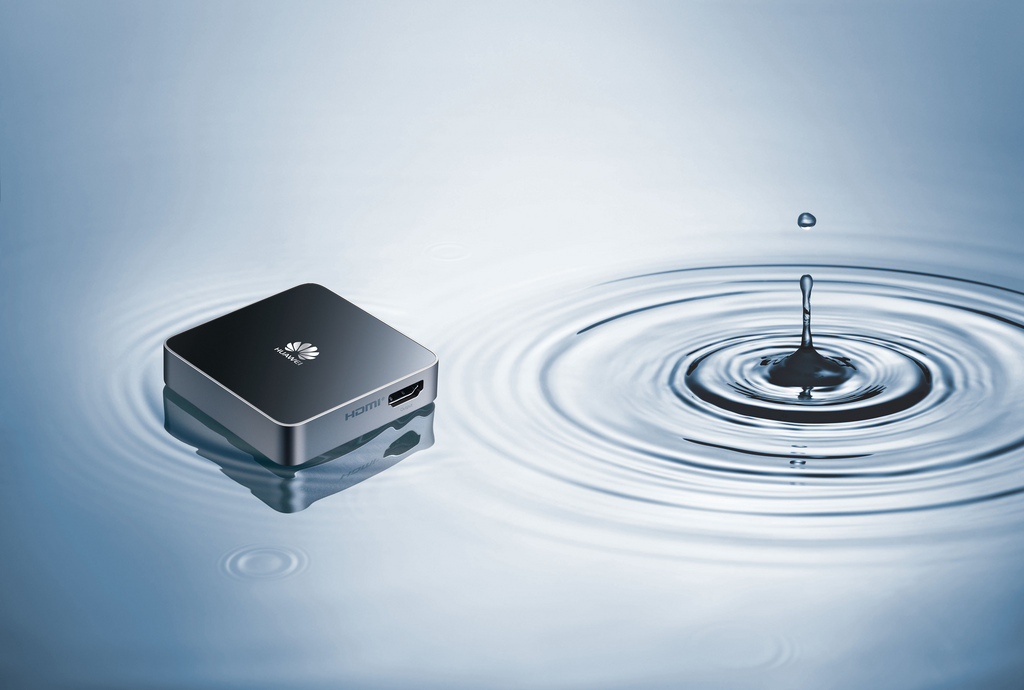
Huawei, a global information and communications technology (ICT) solutions provider, unveiled a series of products heralding the company’s first foray into telematics solutions at the 2013 Mobile World Congress, being held this week in Barcelona, Spain.
Huawei showcased its vehicle-compatible 3G and LTE communication modules, MU609T and ME909T, its 3G mobile hotspot, DA6810, and its 3G onboard diagnostic (OBD) box, DA3100. Huawei’s products for vehicles provide stable wireless solutions in diverse environments regardless of weather conditions, terrain, or reliability of power supply, providing new development opportunities for the automotive industry, and unsurpassed convenience for car owners.
“Huawei is excited to welcome in an era of smart vehicles with the availability of products that integrate wireless communications and automotive electronic technologies,” said Kevin Liu, vice president, Mobile Broadband Division, Huawei Consumer Business Group. “Huawei’s telematic solutions are designed to enable cars and other transportation vehicles to exist in a seamless wireless mobile environment, so that users are truly able to enjoy the benefits brought about by ICT services.”
The MU609T and ME909T are Huawei’s first 3G and LTE communication modules for vehicles. They are both pin-to-pin compatible, and cater specifically to the working enviroment temperature and power consumption of the automotive industry. The MU609T can support up to 14.4M under the HSPA+ network, and the ME909T can support up to 100Mbps under the LTE network. Both modules are pre-installed with GPS and eCall. In addition, the FOTA remote firmwire upgrade capability makes it possible to integrate new technologies into existing MU609T and ME909T modules. The strengths of MU609T and ME909T have been recognized by leading global car manufacturers, and will be integrated into the wireless communication systems of some of the world’s top vehicles in the near future, the company said.
The DA6810 3G Wi-Fi Box creates 3G Wi-Fi hotspots in mobile environments to provide high-speed internet connectivity on-the-go. Once installed with the HUAWEI DA6810 3G Wi-Fi Box, a vehicle becomes interactive, high-tech and networked, providing owners with a high-speed internet and audio-visual entertainment experience, Huawei said.
The DA3100 is an on-board diagnistics (OBD) data transferring system that enables insurance providers and fleet management companies to retrieve information such as location, vehicle conditions and driver habits. This in-car system transfers information in real time through a 3G network to the telematics service provider (TSP) platforms of various third-party entities. It also enables vehicle owners to activate the car horn, headlights and windows remotely via smartphone apps. The DA3100 is powerful yet easy to install, is not limited by geographical region or vehicles types, and can be activated upon installation, Huawei said.
 , which incorporates RapidEye data, has come to a close and results are now available on the project’s website.