The GPS Fiber Optic Distribution system from Optical Zonu connects up to 32 remote locations, transporting GPS signals from a single antenna to as many as 32 GPS receivers (or multiple antennas to multiple receivers). A common example of this application is a campus scenario where installing multiple GPS antennas is impractical. This particular system consists of the OZC J‐Series 5‐Slot modular 1U chassis. The Master Unit is located within close proximity of the GPS antenna and it contains modular and hot‐swappable fiber optic transmitter, AC power supply and J Optical Splitter cards. The remote unit is a stand‐alone (wall mountable) unit. It comes in a low profile semirugged package. A single 1U chassis at the master site is capable of supporting up to 32 remote locations.
The optical transmitter module has built‐in LNA for high sensitivity detection of low level GPS signals. The Master Unit also has a Bias‐T to provide DC power to the GPS Antenna. Local monitoring is also integrated into the Master Unit, which is accessible via a single computer interface terminal. The maximum RF input signal into the transmitter is ‐25 dBm and the RF interface is via a 50 Ohms SMA connector. The standard optical connector is SC/APC (FC/APC is also available upon request) for low back reflection applications. The system is designed to operate on single mode fiber but may be custom configured to work on multimode fiber. The system is configured for complete dual redundancy, including additional fiber optic Tx module for a second GPS antenna.
CSR plc has debuted the SiRFstarV 5e, a GNSS engine optimized to enable highly accurate location positioning for devices including mobile phones, cameras, and health and fitness products. By supporting fully concurrent GLONASS, GPS, QZSS, and SBAS from ROM, the highest accuracy and fastest time-to-first-fix (TTFF) are ensured.
Wireless solutions specialist Telit Communications plc will be using the solution for its Jupiter SE868-V2 module, which was launched at CTIA Wireless 2013 in Las Vegas. The 11 x 11 millimeter QFN packaged receiver module integrates 5e, TCXO, SAW, and RTC oscillator into a small convenient package, accelerating time-to-market and reducing product development risks. CSR believes its advanced power saving modes make it extremely battery-power friendly and ideal for wearable and personal navigation applications.
“The Jupiter SE868-V2 excels in all positioning tasks and foremost in applications requiring high reliability navigation,” says Felix Marchal, Chief Product Officer at Telit Wireless Solutions. “By using CSR’s SiRFstarV 5e solution, we have been able to create a quick and convenient upgrade path for our Jupiter JF2 GPS module customers to the latest and most robust multi-constellation support available in the market.”
SiRFstarV 5e offers a range of features to increase accuracy, improve time to first fix and preserve battery power to enable a better user experience. These include:
InstantFix Extended Ephemeris (EE) — Devices without wireless connectivity, such as cameras, are able to overcome slow TTFF, a common annoyance for the end user. 5e is capable of autonomously forward predicting EE for three days locally, and for connected devices the solution supports server based EE for up to 31 day for GPS and up to 14 day GLONASS EE
Direct to battery capability — The GNSS chip can connect directly to a Lithium battery supply, enabling system cost reduction and increased power efficiency. This is implemented by an integrated switched PMU, reducing system level power and eBOM costs
Design flexibility for optimal solution cost — With clear attention to solution implementation, 5e is designed for small size and low power. For example, UART and SPI Flash drive levels are drivable from 1.8v to 3.3v, eliminating the need for level shifters and increasing implementation flexibility
Intelligent design — The 5e is designed to be optimised for low power battery operated devices. For instance, in asset tracking applications, the 5e engine will intelligently decide how long to try to acquire satellite signal based around its environment, saving a significant amount of battery power
“The SiRFstarV 5e device allows our customers to select a high performance solution that will deliver end users a seamless navigation and location experience whatever the application,” says Dave Huntingford, Director of Location at CSR. “The fact that Telit has already seen the potential of SiRFstarV 5e and selected it for its Jupiter SE868-V2 module reflects the location accuracy benefits afforded by the 5e.”
SiRFstarV 5e is offered in a size optimal 0.4-mm pitch Wafer Level Chip Scale Package (WLCSP) and a 0.5-mm pitch Ball Grid Array (BGA) for low cost PCB applications.
Leica Geosystems has launched Pegasus:One, a flexible, mobile mapping platform that offers an intuitive mobile mapping solution for professionals. Pegasus:One allows service providers to use their existing terrestrial scanner in profiler mode for mobile mapping. Pegasus:One is vehicle independent and comes self-contained in two Pelican cases, enabling users to fly in, map, and fly out.
The Leica Pegasus:One mobile mapping software platform, ArcGDS, draws on synergies resulting from Leica Geosystems’ recent acquisition of Geosoft S.r.l. and is a complete solution from data acquisition to post-processing to database, Leica Geosystems said. It offers users immediate access to their imagery and point cloud data together in the same GUI. Users navigate visually through their images, clicking in their street views, and can add GIS metadata or calculate distances on the fly. Both the imagery and point cloud are calibrated together, so clicking in one immediately provides access to the data in the other.
With nearly 1 billion stop signs and 3.9 million miles of public road in the United States alone, transportation-related asset management provides substantial opportunities, Leica Geosystems said. Additionally, the introduction of new driver assisted technology for cars is putting tremendous pressure on transportation departments to document their highway systems to enable this technology to work successfully. The Leica Pegasus:One provides a solution for both applications.
In the United States, more than 700 thousand billboards exist with new laws limiting the total number of billboards allowed and their placement. Ensuring compliance will generate revenue for states and municipalities around billboard placement, and is now cost effective with the Leica Pegasus:One platform – by simply driving by, Leica Geosystems said.
“Leica Pegasus:One is an enabling product,” said Stuart Woods, vice president for Leica Geosystems’ Geospatial Division. “By providing a single integrated solution and by making our customers’ scanners mobile, we enable our customers to be more efficient.”
In situations where users want or can only afford to capture images, Leica offers an image-only system without a scanner. This provides the same calibrated camera and leverages photogrammetry software to calculate distances from the images – ideal for GIS applications. No longer is the only option a “video recorder on wheels” — now images can be used for distance calculations, Leica Geosystems said.
Spirent Communications’ new SS6425 multi-frequency GNSS record and playback (RPS) test system provides RF recordings for more constellations (GPS, GLONASS, Galileo, BeiDou, QZSS), more frequencies (L1, L2, L5), wider bandwidth (30MHz) and more features than the company’s previous systems, to support a wide range of positioning and timing test applications.
The test system is self-contained and portable, enabling users to record and playback data in the field without the need for an additional PC or external power. With the GSS6425, it is simple to faithfully capture and replay complex signal conditions, such as urban environments, indoor spaces like airport terminals, and dense forests, Spirent said. Multiple environments can be brought into the lab and replayed in a repeatable and controlled manner, helping developers improve receiver and system performance.
“Customers have told us they want to record multi-GNSS signals simultaneously, for example GPS, GLONASS and BeiDou,” said Rahul Gupta, product manager for Spirent’s positioning division. “They have also told us that capture and playback of other data, such as inertial or vehicle CAN bus is needed. The GSS6425 enables all this in a very capable, yet easy-to-use and self-contained unit.”
Users can select and record three GNSS frequency bands at any one time, each with up to 30MHz bandwidth. If more than three concurrent channels are required, two GSS6425 units can be synchronized in a master and slave configuration. For example, survey-grade receiver developers can capture GPS L1, L2 and L5 signals, GLONASS L1 and L2, plus satellite-based augmentation system (SBAS) signals such as StarFire or OmniSTAR.
The GSS6425 is also capable of recording additional sources including inertial and dead reckoning sensor outputs and vehicle CAN bus data. Data can be time-stamped and stored in the GNSS data file, ensuring synchronized playback. The GSS6425 can also record the GPS receiver 1pps (pulse per second) output for synchronization purposes. These features are particularly useful in developing hybrid receivers such as for automotive and indoor positioning applications, Spirent said.
Key features include:
Multiple constellations and frequencies
GPS, GLONASS, Galileo, Beidou, QZSS
L1, L2, L5
Self-contained portable unit
No PC or external drives required
Control from front panel, webserver or scripts
OCXO used on record and playback for frequency stability
Internal 1TB hard drive with additional removable 1TB hard drive
Synchronization of two units in master/slave configuration to support total of 6 frequencies
Store asynchronous or synchronous external data at the same time as GNSS signals
Recorder features:
Record any three RF grequencies simultaneously
Internal battery (up to 1.5 hr) and vehicle DC power adapter
2-bit quantization
Single-touch record
Event markers
Playback features:
Attenuation control per channel
Browser control over network
Multiple file playback
Start at any point in a file
Scripts allow inclusion in automatic test routines
Hemisphere GNSS has launched its new Crescent Vector H200 GNSS compass module, a high-performance receiver for heading, positioning, heave, and attitude. Vector H200 is designed for professional marine, navigation, and land applications in challenging and dynamic environments.
Vector H200 processes L1 GPS and GLONASS signals to deliver precise heading, greater positioning reliability, and better performance in challenging environments, Hemisphere GNSS said. Through using two separate antennas, Hemisphere GNSS’ patented Vector technology computes the heading and pitch or roll angle while stationary or in motion. Vector H200 can compute heading accuracy to 0.02 degrees using a 5-meter antenna separation. A variety of differential correction methods also make it possible for Vector H200 to provide sub-meter to centimeter position accuracy.
Marine industry developers can maximize performance by integrating Vector H200 into their systems for hydrographic and bathymetric surveys, auto-pilots, dredging, and buoys. For land applications, Vector H200 is ideal for aligning cameras, antennas and projectiles, and for machine control applications in agriculture, construction, and mining.
“System integrators have a lot to gain from Vector H200’s powerful combination of navigation and machine control orientation capabilities,” said Ron Ramsaran, Sr. Product Marketing Manager at Hemisphere GNSS. “They will appreciate the performance and value from such a small board package.”
Vector H200 supports SBAS, L-Band and RTK differential positioning solutions and features our exclusive SureTrack technology optimizing the use of GPS and GLONASS signals. Hemisphere GNSS offers precise GNSS antennas to fit a variety of Vector H200 applications.
Newly released Leica GeoMoS 6.0 software includes automatic scanning and deformation analysis integrating the new Leica Nova MS50 MultiStation to scan areas of inaccessible manmade and natural structures. The monitoring data is also processed automatically with the new n.Vec technology implemented by Leica Geosystems. Color-coded, visualized 3D deformation clouds enable easy analysis and interpretation of movements so users can make the right decisions to rectify static problems or protect peoples’ lives.
Leica Geosystems announced version 6.0 at a media event held during the HXGN Live conference in Las Vegas today.
Leica GeoMoS Scanning is an automatic scanning solution fully integrated into Leica GeoMoS Monitoring Solution. This ensures fast integration with existing Leica GeoMoS projects and an easy start for new users, Leica said. In addition to total stations, GNSS, tilt and geotechnical sensors, highly detailed scanning can now be added to the automated measurement cycle. The new scanning module is easy to configure and provides the complete workflow for automatic acquisition and processing of the data to visualize deformations and to notify key personnel in the case of an event. With Leica GeoMoS Web, the data can be accessed anywhere at any time. Leica GeoMoS 6.0 enhances conventional monitoring methods with automatic scanning of surfaces with the Leica Nova MS50 MultiStation. Used for inaccessible places or locations where prisms cannot be installed, e.g. a road cover, a roof, a pipeline or a natural structure, Leica GeoMoS real-time scanning solution monitors any deformation and makes sure that no movement is undetected. The big advantage of using the Leica Nova MS50 MultiStation is that it combines laser scanning and prism monitoring, and therefore the measurements to stable control points guarantee highly accurate setup corrections, including orientation and translations. Additional imaging functionality complements the set by providing yet another information source for better deformation analysis. The implemented scan wizard allows the image-assisted definition of scan areas using different parameter settings and different scan result types. Once defined, the scan area can be scanned manually and via the automatic measurement cycle.
Leica GeoMoS 6.0 enhances conventional monitoring methods with automatic scanning of surfaces with the Leica Nova MS50 MultiStation.
The new scanning feature uses all current automatic functionalities such as automatic measurement cycle scheduling, real-time notification via e.g. SMS/email, automatic limit level check, etc. In addition, the embedded point cloud and image viewer assures powerful 3D visualization of all results using color-coded deformation clouds with a fully traceable history of deformations of the scanned area.
The new n.Vec technology in Leica GeoMoS 6.0 provides automatic scan cloud processing to deliver the real-time information about deformations. The data can quickly and easily be interpreted for informed decisions. Leica Geosystems’ unique n.Vec processing technology uses normal vectors to determine movements in man-made and natural structures through color-coded deformation maps. The deformation maps are created by comparing normal vectors from a reference epoch and the current epoch. To ensure maximum deformation interpretation quality, in an iterative and fully automatic procedure, n.Vec removes non-surface related scan artifacts to ensure uncontaminated surfaces and hence correct normal vectors.
Photo : Leica NovaThe Leica media event at HXGN Live Conference in Las Vegas. Photo : Leica Nova
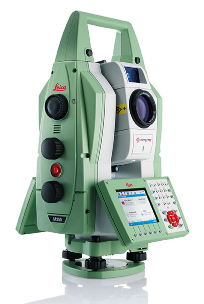
At a media event held during the HXGN Live Conference in Las Vegas today, Leica Geosystems introduced several new products. The highlight of the event was presentation of Leica Nova and the Leica Nova MS50 MultiStation.
The Leica Nova measurement solution is designed to provide users with a complete and seamless workflow, Leica Geosystems said. It integrates advanced measurement technology, modern and intuitive field software, intelligent office software, and Leica’s services to give users the ability to make faster, smarter decisions, across a range of applications. The flagship of the new solution is the Leica Nova MS50 MultiStation, which combines scanning, total station, imaging and GNSS positioning in one instrument to deliver fast and reliable results.
Leica Nova uses advanced measuring technology that provides accuracy and quality, yet is easy to use for an unprecedented range of applications, Leica said. The Leica Nova solution covers the complete process from capturing and visualizing data, to creating intelligent deliverables that shape the world. Whether users measure objects on a construction site, quickly calculate volumes, monitor a dam or a bridge, capture an accident scene with digital imaging or scan a façade, Leica Nova integrates all these capabilities in one compact, flexible solution.
The Leica Nova MS50 MultiStation. Photo : Leica Nova
The Leica Nova MS50MultiStation combines every significant measuring technology in one device for the first time, Leica said. Precision 3D scanning, extensive and precise total station capabilities, digital imagery and GNSS connectivity are brought together in the multistation. The new mergeTEC technology fuses hardware capabilities with comprehensive data-management solutions. Images are synchronized with scans, and scans are tied into total station measurements, making it easy to manage complex 3D data, Leica said.
The Leica Nova MS50 integrates 3D point cloud measurements into regular survey workflows. Users can collect and visualize their topographic survey data with detailed high-precision scans. They save time by computing results and verifying the integrity and completeness of data immediately in the field, avoiding costly reworking or returns. Ultimately, users benefit from better decisions with richer and more detailed data.
Also part of the innovative new Leica Nova solution are the Leica Nova TS50 high-precision total station and Nova TM50 monitoring station.
The Leica Nova TS50 high-precision total station has 0.5-inch angular accuracy and an optimum combination of angle and distance measuring. Integrated overview and telescope cameras with fatigue-reducing autofocus document the scene with high-quality photogrammetric images using the latest SmartWorx on-board software.
The Leica Nova MS50. Photo : Leica Nova
The user sees on the remote control display exactly what the Leica Nova TS50 sees, allowing for easy one-person data capture. The Leica Nova TS50 allows full control through “tap and turn” without the need to go to the instrument and back again. The 20-Hz live video stream can be combined with a graphical overlay for cost-effective recording with immediate clarification of ambiguous situations. Together with the benefits of GNSS connectivity, the Leica Nova TS50 offers complete versatility by delivering reliable results, Leica said.
For critical monitoring tasks, the new Leica Nova TM50 monitoring station provides the highest angle accuracy and offers short measurement cycles through high speed Piezo drives and a fast, highly accurate EDM. The Leica Nova TM50 includes 0.5″ angular accuracy and can measure up to 3’000 meters, which makes it the ideal sensor for monitoring tasks in mines, landslides, etc. For additional documentation, the monitoring sensor includes an overview camera and a telescope camera with 30x magnification and autofocus. The Leica Nova TM50 meets the challenge of 24-hour-a-day, 7-days-a-week monitoring applications. The Leica Nova TS50/TM50 instruments are IP65 rated and designed to withstand the roughest use in the most severe environments.
Leica GeoMoS 6.0 enhances conventional monitoring methods with automatic scanning of surfaces with the Leica Nova MS50 MultiStation. Photo : Leica Nova
The Leica software portfolio includes the following:
With the new Leica Infinity software, users can seamlessly manage, visualize, process and georeference combined total station, imaging and scanning data from the Leica Nova MS50 MultiStation and other Leica Geosystems sensors.
For AutoCAD users who have never before worked with rich point clouds or 3D datasets, the new Leica MultiWorx for AutoCAD plug-in software offers a simple way to integrate point cloud processing into existing workflows.
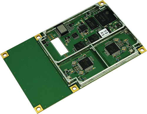
Nexteq Navigation has launched accelGRx, a platform for accelerating professional-grade GNSS receiver development. The platform provides open and production-ready hardware and software building blocks for GNSS receivers. accelGRx is designed for organizations looking to research and develop new techniques and algorithms requiring deep in-receiver integreation or quickly produce a small, high-performance receiver.
accelGRx supports GPS L1 and Beidou B1, and the hardware is GLONASS and Galileo ready. It pairs a compact form factor and industry standard pin layout with a code and phase precision of 4 cm and 0.4 mm respectively for both GPS L1 and Beidou B1. It incorporates an array of software development tools, including the ability to record and play back digitized signals.
An accelGRx licensee wil have tools to develop and test new deep in-receiver integration techniques and algorithms:
• Access to all source code, logic and tools
• Deep in-receiver access to real-time GNSS information
• PC-based software model of receiver platform
• Store and playback of digitized signals for development and testing
• Testing with production-ready receiver and real-world conditions
An accelGRx licensee will have the necessary assets and tools to begin commercialization immediately after development is complete:
• Hardware design (schematic, PCB layout, and BOM)
• FPGA logic design
• Full tracking and PVT source code
• Receiver operating system
• Design documentation and manuals
Nexteq also released two other products:
matrixRTK is a combination of the PPP and network RTK approaches to benefit network-RTK vendors. matrixRTK has the benefits of network RTK (fast initialization) with the benefit of PPP (no baseline restrictions).
L1-RTK-systems is a solution that allows our handheld users to use 2/L1 high sensitive GNSS handhelds working as base and rover to achieve 2-20 cm level accuracy. This is a reliable and cost-effective solution for field workers, Nexteq said.
The Instant Alert Device enables drivers to immediately notify dispatch. Photo: GPSTrackIt
GPSTrackIt has developed an Instant Alert Device that can attach to a driver’s keyring, to enable mobile workforce team members to communicate with their dispatchers or fleet managers. If a driver is in trouble, help can be on the way with the touch of a button.
The compact communication device enables drivers to signal for help even if they’re not with the vehicle. Dispatchers are alerted that a driver is in trouble, and can provide vehicle location information to first responders for expedited assistance.
“The device works in a similar fashion to an electronic key,” explains Eddie Bermudez, GPSTrackIt product manager. “It’s a small plastic box with a single button on it. The driver can carry it on his or her keychain. So even if they’re not with the vehicle they can still call for assistance.”
When the button on the device is depressed, it sends a signal wirelessly to a receiver connected to the tracking device in the vehicle. The Instant Alert Device has a range of up to 500 feet.
Bermudez offered an example. “Let’s say you dispatch someone to a remote oil field and there is no cellular communication out there. The tracking device uses both GPS and satellite communications, a combination that provides optimum coverage. The worker can use the Instant Alert Device to notify their team members back at the office if something is wrong or to acknowledge the completion of a task. This gives real-time, up-to-the-minute notifications to the alert contacts via Fleet Manager.”
The feature can be used with any type of switch, button or Power Take Off (PTO) that connects to an input wire on the tracking device.
C-Nav, supplier of international GNSS Precise Point Positioning services, has launched its latest GNSS real-time tide measurement package, C-Tides.
The C-Tides suite combines the vertical accuracy of C-Nav’s GNSS Precise Point Positioning service with the latest advanced ocean and coastal tides models, the company said.
C-Tides Online features real-time filters and vessel dynamics, a choice of worldwide Mean Sea Surface or regional reference frame models, and tidal prediction for mission planning.
C-Tides Offline utilities include data smoothing and outlier rejection, harmonic analysis, Doodson X0 filter, and a LAT option.
“It’s been a privilege working with our academic partners to develop what is probably the worlds’ most advanced real-time GNSS tide solution,” said Russell Morton, C-Nav head of development.
C-Tides is a fully supported C-Nav utility. The results are suitable for combining with other suitably calibrated vertical components to achieve IHO SP44 Order 1 or better.
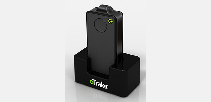
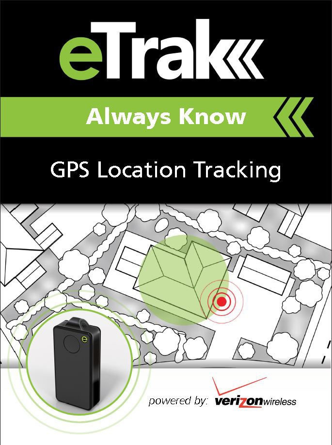
eTrak has released its GPS+ line of consumer and commercial tracking products. GPS+ is eTrak’s patent-pending technology that integrates Wi-Fi, cellular triangulation and GPS to achieve the most accurate positioning possible, both indoors and out, eTrak said.
GPS+ delivers accurate location in real time directly to a smartphone, tablet or computer. eTrak products also contain geofencing capability, which triggers notifications if the device goes beyond preset boundaries. Additionally, the notifications provide a map and address with the location of the device.
“Small and large businesses will benefit from tracking their assets with loss prevention and cost savings,” said eTrak CEO, John Harris. “They will also be able to keep their employees safe and know if they are in danger or need assistance.”
Set-up and the use of eTrak products is simple, the company said. Users can go to eTrak.com and start tracking from any smartphone, tablet or computer and instantly see the location of the eTrak device. The eTrak consumer device is also equipped with an emergency panic button that sends help requests to predetermined recipients in the event of an emergency.
“eTrak is the size of a domino and weighs less than an ounce,” Harris said. “eTrak provides the longest battery life available, and is a low cost personal emergency-response product. And with Verizon’s industry-leading coverage map, it works almost anywhere.”
The eTrak product line encompasses commercial applications, as well as consumer segments including health-impaired, special needs, teens and pets. eTrak also supplies custom design and development services.
An ITT Exelis product that detects and locates GPS interference sources in 3-D by using longitude, latitude and altitude has successfully completed a significant integration milestone.
Signal Sentry 1000, formerly known as GPS Interference, Detection and Geolocation, may now be deployed to collect actionable intelligence for law enforcement, such as tracking high-value targets and protecting critical infrastructure.
Signal Sentry 1000 is a proprietary product that leverages GNSS signal domain knowledge; it is based upon patented technology developed by Exelis through many years of designing and fielding electronic intelligence systems, ITT Exelis said.
“Exelis developed Signal Sentry 1000 to help protect critical infrastructure and to deliver intelligence to law enforcement operations that depend upon GPS availability,” said Kevin Farrell, positioning, navigation and timing general manager for Exelis Geospatial Systems. “Jamming devices can transmit signals capable of disrupting the synchronization of critical infrastructure, such as utility power grids, and timing information of financial transactions. This is why we are continually making improvements in our technology, and the latest milestone achievement is a testament to our goal to deliver actionable interference intelligence to agencies that rely upon GPS operational availability.”
Signal Sentry 1000 technology is a network of threat-detection sensors, which are part of a centralized server executing Exelis‐developed proprietary location algorithms. These sensors can be strategically located around areas of critical infrastructure, such as shipping ports, utilities and government facilities to automatically sense and locate any intentional or unintentional GPS jamming source. Should a threat be detected, users would receive accurate location information and actionable intelligence in order to determine an interference-mitigation plan.
“Signal Sentry 1000 builds upon Exelis expertise in the field of GPS and positioning, navigation and timing. Exelis payloads and payload components have been on board every GPS satellite for nearly 40 years,” said Farrell. “Today, Exelis is involved in GPS modernization initiatives, building tomorrow’s GPS III satellite constellation by developing and integrating the navigation payloads. Exelis is also providing navigation processing components, precision monitor station receivers, and key components of the system security design for the GPS Operational Control System, also known as OCX.”