Tag: product showcase

  • Janam Announces 3G/4G Cellular Rugged Mobile Computer

    XT85.NAngle.left.RGB.MR-W
    Photo: Janam Technologies LLC

    Janam Technologies LLC, a provider of rugged mobile computers that scan barcodes and communicate wirelessly, today announced the release of its new XT85, a high-bandwidth wireless rugged mobile computer designed to support demanding enterprise applications in equally demanding outdoor environments.

    Janam’s XT85 offers a complete set of features that enterprises require in a rugged wireless wide area device, at a price point that makes extending enterprise mobility affordable, Janam said. It is equipped with high-sensitivity GPS with anti-jamming technology.

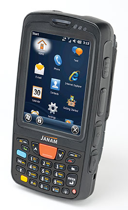
    The XT85 survives multiple 5-foot drops to concrete at temperature extremes (and 6-foot drops at room temperature), offers a 3.5-inch high-transmissivity display that maximizes outdoor readability while minimizing power consumption, offers advanced 4G-ready cellular network connectivity with five-band UMTS for global roaming, and is small and lightweight.

    “Purpose-built mobile computers must appeal to today’s information worker who expects a device that is small, light, fast and highly capable while also serving the business needs of the enterprise for whom the mobile worker is performing mission-critical tasks,” said Harry B. Lerner, CEO of Janam. “Janam’s XT85 is optimized to appeal to both constituencies. It’s much more than a smart phone. It’s a brilliant PDA.”

    In addition to 4G-ready UMTS/HSDPA/HSUPA/GSM wireless wide area network communication, the XT85 is equipped with 802.11 a/b/g/n WLAN with enterprise-grade security and Bluetooth.  It is available with the SE965HP laser engine from Motorola or Honeywell’s Adaptus Imaging technology. Purpose-built to accommodate the realities of work processes and environments, the XT85 is UL-certified for use in hazardous environments, sealed to IP65 standards and available with QWERTY or numeric keypads.

  • Magellan Debuts SmartGPS Apps for Apple and Android Mobile Devices

    Magellan SmartGPS App_iPhone
    screenshot: Magellan SmartGPS App

    Magellan has announced Magellan SmartGPS Apps for iOS and Android mobile devices.

    Following the recent announcement of Magellan’s SmartGPS device, the free Magellan SmartGPS Apps for iOS and Android devices are the next key elements in Magellan’s Smart Ecosystem, a cloud platform that integrates social media and navigation content directly onto a navigation map, the company said. The SmartGPS Apps automatically deliver continually updating reviews and tips for local businesses from social media including Yelp, Foursquare, and other partners to create current, local and personalized driving and pedestrian experiences.

    The Magellan SmartGPS mobile apps display location-relevant information “squares” that graphically flip to show reviews, tips and offers from Yelp and Foursquare for nearby restaurants, stores and services. Users can then navigate to those locations directly from the SmartGPS App without needing to open an additional application or device. The cloud architecture enables new monetization of end users’ mobile search and navigation, and additional social media and content partners.

    “We architected the Smart Ecosystem to integrate with automotive infotainment and mobile network service platforms so users can enjoy a truly mobile, connected car experience now,” said Peggy Fong, president of MiTAC Digital Corporation. “SmartGPS mobile apps connect to the vehicle dash, allowing users to easily search social media and points-of-interest for destinations, and send the locations via Bluetooth or Wi-Fi to SmartGPS-enabled vehicle navigation systems.”

    Magellan’s free iOS and Android SmartGPS apps create a total-solution SmartGPS experience that is truly mobile. Magellan connects the smartphone to the vehicle dashboard, enabling location sync and sharing, hands-free operation and data connectivity. Users can pair their Magellan SmartGPS app with SmartGPS-enabled navigation systems. Using their SmartGPS App, SmartGPS enabled navigation system, or PC, users can search for a location, save the location in Magellan’s Smart Ecosystem cloud, and sync and share the location to any SmartGPS enabled device via Wi-Fi or Bluetooth.

    The free Magellan SmartGPS Apps will be available in North America this Spring, and in Europe this Summer, from iTunes and Google Play. Premium versions of both apps featuring spoken turn-by-turn navigation will also be available.

  • Broadcom Introduces Femtocell Chip to Integrate RF and Baseband Modem

    Broadcom Corporation introduced at the Mobile World Congress a highly integrated digital baseband processor and RF transceiver designed for 3G femtocell residential access points, the BCM61630 systems on chip. The Mobile World Congress is being held in Barcelona, Spain, this week.

    The new devices integrate a multiband CMOS RF transceiver with GPS and full-time sniffing capability while maintaining software compatibility with all previous Broadcom WCDMA physical layer and backhauling interface architectures.

    With the new chips, mobile operator OEMs and ODMs have a powerful, low-cost, power efficient device to support small cell strategies and meet growing mobile traffic demands. Embedding a high-speed CPU and Broadcom’s Layer 1 modem and peripherals, these devices provide a complete low-power single-chip solution for residential and small enterprise 3G small cell deployments, the company said.

    “As on-the-go content consumption continues to drive traffic growth, mobile operators must meet consumers’ increasing demand for higher bandwidth without sacrificing quality of service,” said Greg Fischer, Broadcom’s vice president and general manager for Broadband Carrier Access. “Broadcom’s BCM61630 SoCs deliver a low-power, cost-efficient device for residential small cells to leverage existing mobile infrastructure and deliver faster data speeds through a smaller form factor.”

  • Ruckus Wireless Offers Wi-Fi Solutions for Rising Data Demands

    Ruckus Wireless, Inc. today outlined its SmartCell architecture for creating carrier class Wi-Fi networks to deal with the densification challenge sweeping the industry. Built on its SmartCell Architecture, Ruckus unveiled a wide range of new carrier-class Smart Wi-Fi products, including the Ruckus ZoneFlex 7782 family, which integrates a GPS receiver. The announcement came at the Mobile World Congress being held in Barcelona, Spain, this week.

    The rapid growth of mobile data services, driven by smartphones, laptops, and tablets has accelerated data-traffic growth to the point where macro cellular networks are no longer sufficient to meet subscriber demand in many high-density indoor and outdoor settings. While new macro cellular technology, such as long-term evolution (LTE), is being introduced to address this capacity crunch, it will provide only partial relief, as traffic volumes continue to grow faster than operators can economically add capacity, Ruckus said.

    Consequently, mobile operators are rapidly adopting Wi-Fi as an additional radio access network (RAN) option to augment mobile capacity. At the same time, fixed line carriers and multiple system operators (MSOs) are also deploying Wi-Fi for public access to enhance their service offerings, reduce subscriber churn and enter new markets such as managed enterprise wireless LAN (WLAN) services.

    For high-capacity outdoor environments, such as stadiums and other public venues, the Ruckus ZoneFlex 7782 outdoor AP Series is a family of four new, high-capacity Wi-Fi access points designed to give service providers unprecedented capacity and performance. With models supporting omni-directional antennas, 120º sectorized, and 30×30º narrow-beam coverage through integrated internal antennas as well as external antenna options, ZoneFlex 7782 APs offer a combination of high performance and flexibility in a sleek, low profile, light form factor essential for meeting the tight mechanical and aesthetic constraints of deployment outdoors, Ruckus said.

    Each Ruckus ZoneFlex 7982 AP is a dual-band, three stream (3×3:3) 802.11n access point enabled for high throughput approaching 900 Mbps. ZoneFlex 7782 APs with integrated antennas support Ruckus-patented BeamFlex adaptive antenna technology for greater signal gain and interference mitigation. Additionally, the Ruckus ZoneFlex 7782 family integrates a GPS receiver, allowing service providers to begin providing location-based services as well as continuous spectrum monitoring features.

  • Qualcomm Announces 4G LTE Advanced Connectivity Platform for Mobile Computing

    Qualcomm Technologies, Inc., has announced the industry’s first 4G LTE Advanced embedded data connectivity platform for mobile computing devices, including thin form factor laptops, tablets and convertibles. The technology, based on Qualcomm Technologies’ Gobi chipsets — the MDM9225 and MDM9625 — is the first embedded, mobile computing solution to support LTE carrier aggregation and LTE Category 4 with peak data rates of up to 150Mbps. The announcement came at the Mobile World Congress being held in Barcelona, Spain, this week.

    The Gobi MDM9x25 embedded platform includes an embedded GPS receiver with GLONASS support for enhanced asset tracking, turn-by-turn navigation and other location-based services.

    The introduction marks the arrival of Qualcomm Technologies’ third-generation 4G LTE embedded chip, extends Qualcomm Technologies’ modem technology leadership in mobile computing, and promises to deliver the fastest 3G and 4G LTE connections worldwide, while offering the broadest multi-region coverage via a single SKU solution, the company said. PC OEM customers can  select from embedded module vendors that support a range of Gobi chipsets, from 3G solutions with speeds up to 42Mbps to cutting-edge 4G LTE Advanced. Coupled with pay-as-you-go, no contract data plans, these products enable thinner, lighter and better connected mobile computing devices running leading operating systems such as iOS, Android, Windows 8 and Windows RT, and support a variety of modules for thin form factors, including PCI Express Mini Card, PCI Express M.2, and Land Grid Array.  Additionally, the Qualcomm RF360 Front End solution, providing expanded active band support integral to Qualcomm Technologies’ single SKU LTE World Mode solution will also be included.

    “Our broad portfolio of Gobi chipsets — including 3G 42Mbps, 4G LTE and 4G LTE Advanced — features industry-leading LTE multiband support for seamless connections to the fastest networks worldwide,” said Cristiano Amon, executive vice president of Qualcomm Technologies and co-president of Qualcomm Mobile Computing. “This latest addition can be easily implemented across enterprise, SMB and consumer industries allowing end users to download and stream rich HD content, access enterprise applications, share large files quickly and connect virtually wherever they are in the world.”

    Qualcomm Gobi MDM9x25 chipsets began sampling to module vendors last November and will enable commercial device launches in the second half of this calendar year.

  • CoPilot Brings GPS Navigation to Windows Phone 8

    lumia-920-copilot-ukALK Technologies, provider of navigation and GeoLogistics software, announced at the Mobile World Congress that its CoPilot GPS navigation apps for smartphones and tablets will be available for Windows Phone 8 and Windows 8. The Mobile World Congress is being held in Barcelona, Spain, this week.

    Designed as an alternative to traditional in-vehicle systems, the app provides voice-guided GPS navigation, with turn-by-turn guidance, comprehensive trip planning and automotive-grade street maps stored on-board the device for offline use. Integral real-time services include ActiveTraffic, Yelp, Wikipedia and Google Search to keep drivers fully informed on the road.

    “We’ve always been fans of Microsoft’s mobile solutions,” said David Quin, head of consumer applications at ALK Technologies. “CoPilot was originally developed for Microsoft’s Pocket PC and pioneered mobile navigation on Windows Mobile, so we are delighted to announce a new app for Windows Phone 8 and Windows 8. The Windows family of mobile devices is rapidly gaining momentum as an alternative to Android and iOS, and provides an ideal platform for us to deliver a full-featured and driver friendly CoPilot navigation experience.”

    “Windows Phone is backed by a vibrant app ecosystem with a variety of quality titles, like CoPilot, which help people enjoy a smartphone that is uniquely theirs,” said Todd Brix, general manager, Windows Phone Apps, Microsoft Corp. “CoPilot is a great example of the rich applications that people can enjoy on their Windows Phones.”

    CoPilot for Windows Phone 8 and Windows 8 provides a suite of advanced navigation features, including:

    • Clear, non-distracting 3D map views with lane arrows and signpost display.
    • ActiveTraffic, which calculates the fastest routes and accurate arrival times based on live traffic flow information.
    • CoPilot ClearTurn for navigating complex junctions.
    • On-screen speed limit indicator and excess speed warnings.
    • Advanced trip planning with a choice of three routes and drag-and-drop route editing.
    • Comprehensive local search with integrated Yelp, Wikipedia and Google.
    • Global map regions available to purchase and store on the device as required.

    CoPilot is expected to launch on the Windows Phone Store and Windows Store in summer 2013 with the following versions: CoPilot Premium, a paid app which includes turn-by-turn navigation and 12 months ActiveTraffic; CoPilot GPS, a free offline trip-planning and maps app with in-app purchase for turn-by turn navigation; and CoPilot Truck for truck-specific GPS navigation. Pricing will be in-line with existing CoPilot apps for iOS and Android.

  • Avenza Offers NatGeo Maps Off-Line, Yet Still GPS Interactive

    National Geographic Maps has joined with Avenza Systems to offer a new channel to access its map content. The alliance enhances Avenza’s digital map database by adding more than 500 maps from National Geographic and furthers National Geographic Maps’ established reach with mobile consumers.

    The Avenza PDF Maps app takes advantage of geospatial technology and allows users to view, acquire and interact with maps on their mobile devices, including iPhone and iPad, without needing a mobile data connection or being accessed international roaming charges. PDF Maps offers an in-app store to facilitate the transaction and delivery of the maps, consolidating, in a digital format, consumers’ access to hundreds of maps from multiple publishers.

    “In the last decade, advances in technology have shifted how consumers receive and use information, and we have responded by making our rich map content available on a variety of platforms,” said Charles Regan of National Geographic Maps. “Avenza’s PDF Maps app provides a unique way for consumers to access our content with an easy-to-use in-app map store and a set of robust features that will enhance the map user’s experience.”

    Hundreds of maps from National Geographic Maps’ extensive library are now available in Avenza’s PDF Maps system, including travel and destination titles covering five continents, historical and thematic maps, and educational and reference titles. The app provides constant access to geographic information and points of interest, with additional interactive tools such as measuring, place marking and location tagging. PDF Maps operates without the risk of lost reception, due to cell tower proximity, and does not rely on an Internet connection.

  • Broadcom Launches GNSS Chip with Geofence Capabilities

    Broadcom Corporation has introduced the BCM47521, a GNSS chip with architecture that enables geofence capabilities while preserving battery life. According to Broadcom, the new chip opens the door to always-on location-aware applications such as social networking, place-based mobile commerce and local merchant advertising.

    Broadcom will showcase its GNSS innovations at the upcoming Mobile World Congress show in Barcelona, February 25-28.

    A geographical region of interest (“geofence”) is being used by many new and innovative location-aware applications. The geofence feature enables the application to receive a notification when a user enters or exits a virtual perimeter. However, the implementation of this feature in traditional architectures is not viable, as the applications processor needs to run constantly, causing rapid drain to the device’s battery. Broadcom’s new BCM47521 overcomes this issue, making it possible to continuously monitor geofence areas while consuming 60x less battery power.

    “The astounding growth of mobile devices is driving new opportunities for inventive applications that deliver valuable location-aware information,” said Scott Pomerantz, Broadcom vice president and general manager, GPS. “With the BCM47521’s low-power geofence mode, Broadcom is driving the next wave of system power consumption innovation that will allow OEMs to incorporate features that differentiate their mobile offerings and make location-aware, always-on applications a reality.”

    The BCM47521 chip also provides multi-constellation support by simultaneously collecting data from GPS, GLONASS, QZSS and SBAS, and using the best received signals, resulting in faster searches and more accurate real-time navigation, Broadcom said. Broadcom’s multi-constellation technology, coupled with advanced signal processing, provides faster positioning performance for improved user experience, especially in challenging urban environments where buildings and obstructions can dramatically impact accuracy and time-to-first-fix.

    A key feature is the 60x better system power efficiency versus a host-based architecture. An advanced host-offload mode monitors geofences in the background and only activates the applications processor when there is a trigger event, and smart algorithms adapt in real-time as the user gets closer to a geofence boundary.

  • LOCiMobile Launches Enterprise Work Force Tracking App TMWF

    LOCiMOBILE, Inc., a wholly owned subsidiary of GTX Corp, has launched its first enterprise app for companies looking to effectively track and monitor their workforce in real time. Track My Work Force (“TMWF”) is available for download on iTunes, and based on its early success, is in development for release on the Android platform.

    Once downloaded on either an iPhone or iPad, the app works in the background and reports the whereabouts of that device back to the GTX Corp monitoring back-end. The app was designed for small- to medium-sized companies that have a mobile sales or service workforce and need to know the location of their reps in real time. Companies in the U.S., Canada, Czech Republic and Morocco, in industries including transportation, construction, plumbing, IT, medical and pharmaceutical, have already deployed the TMWF app and the GTX back-end monitoring platform.

    Morocco+All
    In January, a pharmaceutical company based out of Morocco that services 25,000 pharmacies across several North African countries deployed TMWF for 150 of its sales reps.

    “Our diamond delivery business relies heavily on our traveling sales representatives in order to maintain relations with existing customers as well as meeting new ones. GTX Corp’s Track My Work Force app was extensively tested during our system trial,” Jack Daynes of the Diamond Group said. “The results were such that we implemented the program immediately and haven’t regretted it in the slightest. Both the pricing and the service that we’ve received have exceeded our expectations.”

    Companies can easily deploy this technology by leveraging the mass adoption of smartphones and tablets in the workforce, said GTX Corp. In January, a pharmaceutical company based out of Morocco that services 25,000 pharmacies across several North African countries deployed the app for 150 of its sales reps.

    “We are very pleased with the initial feedback and potential of this app,” said Patrick Bertagna, GTX Corp CEO. “There are tens of thousands of companies all over the world that can benefit and increase customer service, productivity and security from two-way GPS technology and are now able to implement this technology with a simple download.”

    The TMWF app is an efficient and cost-effective way for business owners and managers to keep track of and manage their mobile work force, GTX Corp said. It’s faster and safer than text messaging and allows the worker to focus on the task at hand rather than spending valuable time calling HQ to check in and report, the company said. The app costs $9.99 initially, with an additional monthly monitoring service fee that costs around $5.00 per user per month.

    The company provides a free two-week evaluation for any business with more than five employees, and custom solutions along with a licensable white-label platform for larger companies.

  • MEMS IMU for OEM Receivers

    NovAtel-adis-1(NB)
    Photo: NovAtel

    The ADIS16488 is a Micro Electromechanical System (MEMS) Inertial Measurement Unit (IMU) from Analog Devices. It features low noise gyros and accelerometers in a rugged, environmentally sealed enclosure. The ADIS16488 enables precision measurements for applications that require low cost, high performance, and rugged durability.

    At 71 x 46 x 11 millimeters, the OEM-ADIS-16488 features low noise gyros and accelerometers in a small, lightweight form factor. The custom device is designed to be paired with a NovAtel OEM6 receiver card to provide continuously available position, velocity, and attitude (roll, pitch, yaw).

    SPAN tightly couples NovAtel’s precise GNSS technology with highly accurate inertial measurement technology to provide robust, stable, and continuous 3D navigation. Tight coupling of the two technologies enables continuous robust positioning in difficult environments.

  • GPS Module

    The Jupiter SE880 by Telit Wireless Solutions is a small, ultra sensitive 48-channel GPS module that features an advanced 3D technology that improves time to first fix and brings indoor location fix to reality with cold start and tracking sensitivity down to -148 dBm and -165 dBm. The turnkey solution enables the design of ultra-compact applications, requiring minimal external BOM and a footprint of less than 40 millimeters compared to conventional PCB technology.

    The Jupiter SE880 is designed for high-volume GNSS ultra-compact mobile / tracking devices as well as advanced consumer devices such as sport watches and cameras.

  • Taoglas Launches GPS/GLONASS Passive Flexible Loop Antenna

    Taoglas_passive_antennaTaoglas USA, Inc., provider of antenna solutions to the M2M and connected device market, has launched the FXP.611 Cloud, a GPS/GLONASS flexible loop antenna that the company says outperforms most active patch antennas with an efficiency of 80 percent and a peak gain of 3 dBi across the GPS and GLONASS bands (1575 to 1610Mhz).

    This antenna can resist external detuning effects due to dual resonance and has a small form factor of 38 x 37 x 0.1 millimeters. At less than half the cost of heavy active patch antennas, this peel and stick, flexible loop antenna is suitable for any GPS/GLONASS M2M device, Taoglas said.

    “We’ve been blown away by the performance of this linear polarized A-GPS GLONASS antenna,” said Dermot O’Shea, director at Taoglas. “Before we developed the FXP.611 Cloud, we had only seen this kind of performance from active patch antennas. We ran a drive test in downtown San Diego and were surprised by the real-time performance and first time to fix from cold-start of this passive loop, particularly in urban canyons where you expect active patches to out perform.”

    Original equipment manufacturers will find the FXP.611 suitable for assisted GPS/GLONASS applications for industrial handheld devices, tablets and smartphones. According to Taoglas, the patent-pending FXP.611 Cloud antenna

    • eliminates the need for a filter or low noise amplifier (LNA), and can connect directly to a module or to a connector on a board.
    • offers a “peel and stick” mounting with 3M tape that can be attached to plastic device housings freeing up board space.
    • costs half the price of active patch antennas.
    • incorporates a detuning design with dual resonance.
    • radiates power uniformly with an omnidirectional design, making it suitable for use in devices that have fixed positions.

    The FXP.611 Cloud antenna is available for purchase immediately from Taoglas by contacting [email protected] and online later in the first quarter of 2013 with Taoglas distributors.