While UAVs are an exciting new technology for mapping, most respondents to our survey recognize the continued value of hands-on, in-the-field data collection.
Most respondents think UAVs could be used for as much as half of data collection, but very few expect UAVs to be used for more than that. UAVs are just one mobile collection method, of course. Others include autos such as SUVs, boats and all-terrain vehicles.
What role will UAVs play in the mapping industry over the next three years? (Source: GPS World 2018 State of the GNSS Industry survey)
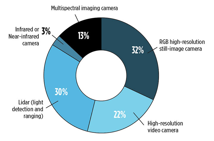
We also asked respondents how they use UAVs for data collection. RGB high-resolution still-image cameras and lidar are the most frequently used, with video cameras not far behind. Other specialty cameras collect infrared or thermal imagery, while specialty sensors collect everything from temperature to pressure and methane levels.
Whether mounted on a UAV, a vehicle, or on the ground, these technologies are used in fields as diverse as forest management, disaster response and infrastructure planning.
For instance, urban planners rely on mapping data for land value, topography and water and electricity resources. Meanwhile, forestry experts use infrared to detect areas of disease or die-off in the early stages.
Software in the Cloud. Turning to software, developments in cloud storage and open-source and subscription platforms are constantly improving geographic information systems (GIS). A wealth of GIS and GPS data is available from Google Maps, Apple Maps, OpenStreetMap and other applications. Specialty applications include Esri ArcGIS, Maptitude, Surfer and more. In the coming years, expect an increase in 3D modeling, digital elevation models (DEMs) and augmented reality.
What is the most valuable sensor to use in conjunction with GPS/GNSS aboard a UAV for mapping and data-collection purposes? What role will UAVs play in the mapping industry over the next three years? (Source: GPS World 2018 State of the GNSS Industry survey)
The automotive sector has been adopting digital mapping applications for use in self-driving cars, as well as fleet management, logistics control systems, and advanced driver assistance systems (ADAS).
Every year, more satellites are launched for mapping and GIS data collection, and they don’t all provide photo imagery. For instance, NASA’s Aqua satellite detected and mapped huge concentrations of carbon monoxide drifting east across the U.S. from western wildfires — important information for public health planning.
For more results from the 2018 State of the GNSS Industry, see this page.
DigitalGlobe has released pre- and post-event satellite imagery of the areas in India affected by heavy flooding.
According to the company, massive flooding devastated the Kerala state of India in late May and early August. At least 164 people were killed and more than 223,000 were displayed from their homes and are living in relief camps. In addition, Kerala has seen 40 percent more rainfall than normal since June, which has triggered landscapes in several districts.
In an effort to support disaster response and as a part of its Open Data Program, DigitalGlobe decided to publicly release the satellite images. According to the company, its Open Data Program supports the humanitarian community by providing critical and actionable information to assist response efforts.
(From left) Francois Lombard and Dirk Hoke, Airbus, sign agreement with Will Marshall, Planet.
Airbus and Planet have entered into a partnership to facilitate access to each other’s data and the co-development of new geospatial solutions.
The companies are establishing a framework agreement to explore opportunities for joint cooperation in new and existing markets, product offerings, sales and marketing efforts.
Both companies aim to provide a comprehensive suite of global satellite data at multiple temporal and spatial resolutions, and develop new analytic products for a wide range of applications to benefit their customers.
Benefitting from both companies’ constellations, customers will have access to the entire Earth’s landmass every day at 3m resolution with PlanetScope satellites, as well as to intra-daily sub-meter resolution imagery with Pléiades and SkySat constellations.
In addition, they will also have the capability to order images with resolutions of 1.5m (SPOT 6/7), 5m (Rapideye) and 22m (DMC Constellation).
Lastly, TerraSAR-X, TanDEM-X and PAZ radar satellites will allow the acquisition of images regardless of weather and daylight conditions, ensuring access to any place on Earth independent of cloud coverage.
“By combining our strengths, we will provide a key capability to address all market needs, both in terms of data and value-added products, and to best serve our clients, whatever their industry and their requirements,” said François Lombard, director of the Intelligence Business at Airbus Defence and Space.
“Airbus and Planet are truly complementary partners. Airbus brings long-standing success in serving reliable, high resolution remote sensing, and Planet brings its unique global coverage and temporal cadence, as well as agile aerospace iteration to get sensors quickly to space,” said Will Marshall, CEO and co-founder of Planet. “Together we will be able to deliver sophisticated offerings to fit customer needs across international markets.”
Airbus Defence and Space is celebrating the 25th anniversary of Eagle Vision, its lightweight deployable imagery downlink ground station designed to process and distribute commercial satellite imagery in near-real time to support U.S. Air Force and Air National Guard missions in homeland security, combat and disaster relief.
Eagle Vision allows downloading and processing of unclassified commercial satellite imagery directly in the field, as the satellite passes overhead, supporting military leaders, even in remote areas and non-anticipated operations. Imagery provided by this system supports wartime operations, natural disaster and relief efforts as well as Homeland Defense preparations.
“Today we celebrate an uninterrupted success since 1993,” said François Lombard, director of the intelligence business at Airbus Defence and Space. “Since then, Eagle Vision has become a valuable source for commercial imagery exploitation for the U.S. Air Force and many entities within the U.S. government, to provide fresh, near-real time satellite data for information extraction in preparation for mission critical applications.”
The system receives and processes SPOT 6 and 7, TerraSAR-X and Pléiades images, and is also capable of processing Landsat, Radarsat, RapidEye, Cartosat, Ikonos, Cosmo-SkyMed and Resurs-DK data.
The Eagle Vision Program has been a valuable asset within the U.S. Air Force for the past 25 years, the company said. The program enables warfighters, first responders and planners to have situational awareness so that they can plan, execute and deliver mission resources efficiently and effectively, Airbus said.
Five Eagle Vision systems have been developed and sustained 24/7 by Airbus Defence and Space for the last 25 years. They are assigned to:
Ramstein Air Base, Germany
San Diego Air National Guard Station, California
McEntire Joint National Guard Base, South Carolina
Esri is releasing Sentinel-2 Image Services to all Esri users for no additional cost.
According to the company, Sentinel-2 is an Earth Observation Satellite that provides multi-spectral imagery for any location in the world at 10-meter resolution. Currently in beta, the service is updated daily with new imagery for all ground locations every five to seven days.
The Sentinel-2 Image Services provide temporal, multi-spectral imagery of the entire globe for improved monitoring of agricultural and forest conditions, monitoring of land cover changes, and to assist with natural disaster management.
Sentinel-2 is part of Copernicus, the world’s largest single Earth observation program directed by the European Commission in partnership with the European Space Agency.
Esri makes the multi-spectral data quickly accessible using ArcGIS Image Server and publishes an image service through the ArcGIS Living Atlas of the World, hosted on the Amazon Web Services Infrastructure.
The service includes all Sentinel-2 imagery going back 14 months, enabling change to be easily reviewed. Image analysis can be run directly on the service to create indexes displaying properties such as vegetation health or soil moisture as well as quantifying the changes over time, for better understanding of the environment.
“We are committed to helping our users discover, explore, and better understand our changing planet,” said Jack Dangermond, Esri founder and president. “Pairing Sentinel-2 imagery with our ArcGIS Image Server provides a powerful platform for in-depth analysis which can inform meaningful action.”
Sentinel-2 multi-spectral imagery can provide better visualization and understanding of catastrophic events such as Hawaii’s Kilauea volcano, the company said. The ability to use imagery of the volcano along with other spatial data, such as digital elevation models, provides an unprecedented opportunity to help predict lava flow direction and provide advanced notice to those who may be in danger.
Sentinel-2 can also help provide understanding of the conditions that lead to fires such as this past winter’s Thomas Fire, which is California’s largest wildfire on record. The Thomas Fire burned more than 280,000 acres and triggered massive mudslides. Visualizing factors, such as periods of increased moisture contributing to more lush vegetation followed by hot and dry weather, can help predict future wildfires and mitigate their effects in the future.
The Sentinel-2 imagery is available through the Living Atlas, the foremost collection of geographic information from around the globe. The Living Atlas is included with all ArcGIS online subscriptions. It is comprised of maps, apps, and data layers that support the work of thousands of Esri users around the world. Full service access, including a rolling 14-month archive of the Sentinel-2 data, is now available to all Esri ArcGIS users.
Less than two weeks after it was launched, the Copernicus Sentinel-3B satellite has delivered its first images of Earth. Exceeding expectations, this first set of images include the sunset over Antarctica, sea ice in the Arctic and a view of northern Europe.
One of the Copernicus Sentinel-3B’s first images featured Greenland. Captured on May 7, 2018, at 13:20 GMT (15:20 CEST), the image shows sea ice swirled into eddies caused by the wind and ocean currents. The image was taken by the satellite’s ocean and land colour Instrument, which features 21 distinct bands, a resolution of 300 m and a swath width of 1270 km. The instrument can be used to monitor aquatic biological productivity and marine pollution, and over land it can be used to monitor the health of vegetation. (Image: ESA)
The very first image, captured on May 7 at 10:33 GMT (12:33 CEST), shows the transition between day and night over the Weddell Sea in Antarctica. The satellite also captured swirls of sea ice off Greenland on the same day. Another in this first set of images offers a rare cloud-free view of northern Europe.
They were taken by the satellite’s ocean and land colour instrument, which features 21 distinct bands, a resolution of 300 m and a swath width of 1270 km. The instrument can be used to monitor aquatic biological productivity and marine pollution, and over land it can be used to monitor the health of vegetation.
Josef Aschbacher, ESA’s Director of Earth Observation Programmes, said, “The launch of Sentinel-3B completed the first batch of Sentinels that we are delivering for Copernicus.
“We finished the launch and early orbit phase in a record time and we are now getting on with the task of commissioning the satellite for service.
“These first images from the ocean and land colour instrument already show how the satellite is set to play its role in providing a stream of high-quality environmental data to improve lives, boost the economy and protect our world.”
The Copernicus Sentinel-3B satellite captured this rare cloud-free view of Northern Europe on May 8, 2018, at 09:33 GMT (11:33 CEST). Features over land and water can been seen clearly such as different types of land cover, snow and also a plume of phytoplankton in the North Sea. The image was taken by the satellite’s ocean and land color Instrument. (Image: ESA)
The Sentinel-3B satellite lifted off from Russia on 25 April and joins it identical twin, Sentinel-3A, in orbit. This pairing of satellites increases coverage and data delivery for the European Union’s Copernicus environment programme.
As the workhorse mission for Copernicus, the two satellites carry the same suite of instruments to systematically measure Earth’s oceans, land, ice and atmosphere.
Over oceans, it measures the temperature, colour and height of the sea surface as well as the thickness of sea ice. These measurements are used, for example, to monitor changes in Earth’s climate and for more hands-on applications such as for monitoring marine pollution.
Over land, this innovative mission monitors wildfires, maps the way land is used, checks vegetation health and measures the height of rivers and lakes.
European Commissioner for Internal Market, Industry, Entrepreneurship and SMEs Elzbieta Bienkowska, said, “This new satellite will deliver valuable images of how our oceans and land are changing.
“This will not only speed up the response to natural disasters, but also create new business opportunities. Earth observation is a larger market than you would think – a driver for research discoveries, a provider of highly skilled jobs and a developer of innovative services and applications.”
One of the Copernicus Sentinel-3B’s first images featured Greenland. Captured on May 7, 2018, at 13:20 GMT (15:20 CEST), the image shows sea ice swirled into eddies caused by the wind and ocean currents, and was taken by the satellite’s ocean and land color Instrument. (Image: ESA)
Bruno Berruti, ESA’s Sentinel-3 Project Manager, said, “We are extremely pleased to see these first images, which show that the satellite is in good health.
“ESA will spend the next five months carefully calibrating the instruments and commissioning the satellite for service before it is handed over to Eumetsat for routine operations.”
During this commission phase the two Sentinel-3 satellites will be flown in a tandem formation, separated by about 30 seconds.
Sentinel-3B will then be phased to reach its final position – flying in the same orbit, but adjusted to be separated by 140° with respect to Sentinel-3A.
Once commissioned, ESA will hand over satellite operations to Eumetsat. It will then be managed jointly, with ESA generating the land products and Eumetsat the marine products for application through the Copernicus services.
Alain Ratier, Director-General of Eumetsat, added, “The Sentinel-3 constellation establishes the European backbone of a space-based, global ocean-monitoring system.
“These first images are the first demonstration that Sentinel-3B will deliver on its promise to usher in a new era for operational oceanography and flow-on benefits for human safety, businesses and industry.
“They will amplify the benefits of the Sentinel 3 mission for ocean forecasting and the blue economy.”
Sentinel-3B is the seventh Sentinel satellite launched for Copernicus. Each mission carries different state-of-the-art technology to deliver a stream of complementary imagery and data to monitor the environment.
An oblique image of downtown Chicago, captured in June 2017, with measurements. (Image: Nearmap)
Guest column by Sanchit Agarwal Vice President, Field Operations, Nearmap
With high-resolution imagery comes the ability to model reality, creating real-life visualizations for engineers, planners, construction teams and many others.
A quantum leap in computing capacity has allowed us to model and analyze the real world — all from our desktop and mobile devices. In days past, maps were purely for visualization and direction.
Today, they have graduated to full-blown analytics platforms empowering users to make decisions faster than ever before.
Why?
They closely represent truth on the ground — truth created from high-resolution aerial imagery captured at heights of up to 18,000 feet. Camera systems mounted in the bellies of planes can efficiently map the real world in incredible high detail. These aerial photographs are updated continuously.
In years past, access to aerial mapping content and services was reserved for more significant players.
Today, with easy access to scalable high-definition mapping content, anyone can utilize the power of maps in applications that extend far beyond directions and navigation.
There are two essential attributes of aerial maps driving this transformation — image resolution and model density. Today, most users are applying low-resolution satellite images that lack the detail needed for accurate decisions. But, as resolution increases, the imagery becomes more detailed; the visualizations, more vivid.
Ground features have gone from fuzzy satellite photos to clearly identifiable homes, buildings, roads, lakes and more — all captured using powerful cameras that have found the perfect pixel. With high-resolution comes added benefit.
Aerial image of the Aria Resort in Las Vegas captured in May 2017. (Image: Nearmap)
Users can manipulate the imagery — zoom closer and closer without losing the details. Computers can classify the features, distinguishing skylights from solar panels, walking paths from sidewalks, and pools from ponds.
Rich imagery is yielding richer data used to instantly query massive databases and return results that answer complex questions for businesses and government.
With high-resolution imagery comes the ability to model reality, creating real-life visualizations for engineers, planners, construction teams and others.
These models of landscapes, cities and neighborhoods are portrayed inside design tools and mapping systems, saving the analyst countless days of traveling to the site only to be surprised that the outdated low-resolution imagery does not depict what’s actually on the ground.
Imagery can vary greatly in resolution. Pixel resolution refers to the actual distance on the ground that each pixel represents in the orthophotography — the vertical image. For example, one-foot pixel resolution means that each pixel in the image covers one foot on the ground.
Common resolutions include three-inch, six-inch, one-foot and one-meter. The higher the imagery resolution (for instance, three inches per pixel), the greater the visible detail within the photograph. Clearly, a three-inch resolution is much better than a one-foot resolution.
Most mapping content currently consumed is two-dimensional and generated from low to mid-resolution nadir imagery. In other words, you see the land as if you were staring straight down at it, not height-of-ground features and certainly not change over time.
While that was adequate for some users, others reached for higher resolution and, while they were at it, decided they needed a third and fourth dimension — namely, height and time. These new perspectives provide more analytical options, more insights and a variety of new use cases that show change over time, height and multi-perspectives of the same property or landscape.
With the democratization of mapping products and services and the general trend toward consumption of multi-dimensional experiences, there is an implicit need to increase resolution, detail, dimensions and perspectives in mapping content and services as well.
The Rancho Mirage community of California, captured in February 2017. (Image: Nearmap)
Traditionally, satellite imagery has been used to monitor large areas of the earth at scale remotely. The resolution of the satellite imagery has graduated from multiple meters to feet with the advent of advanced mapping satellites.
The challenge here is the resolution. Low-resolution satellite imagery, although scalable, is good for macro-analysis of cities and neighborhoods but is not detailed enough for accurate measurements and micro-analysis at the level of each individual property.
On the other end of the spectrum come drone mapping solutions that offer the promise of delivering incredibly high-resolution datasets (sub-centimeter resolution) but fails to provide the scalability and repeatability.
Let’s get specific. Why does resolution matter?
You cannot measure what you cannot see. The resolution of imagery provides a more detailed, zoomed in and richer view of the real world, thereby enabling desktop based reconnaissance, inspection, analysis and measurement of features that are not traditionally visible in satellite imagery.
Higher resolution means high fidelity and dependable measurements. With the added details and definition of features that high-resolution offers comes the much-needed advantage of clearly and legibly identifying feature boundaries and hence measuring the feature with high precision and accuracy.
Higher resolution map content means fewer site visits. Rather than travel onsite to inspect and measure, many organizations are now relying on high-resolution imagery and, in the process, not having to waste resources sending team members on site.
High resolution means more detailed documentation of reality. Gamers have experienced reality-like landscapes for quite some time. Now, 3D and 4D mapping content allows users to immerse themselves in the landscape, navigate through street views, and fly like a bird to inspect rooftops with ease.
High resolution and refreshed content means more accurate change analysis. Identifying how locations have changed over time through multiple captures that embody leaf-off and leaf-on imagery allow users to not only visualize detail but also notice progress, changes in construction, degradation of property features, growth in vegetation and more.
High-resolution content means more automated workflows. High-resolution content allows for better feature definition models resulting in higher success rates in interpreting and analyzing the reality algorithmically. Higher success rates of automated algorithms results in efficient exploitation of datasets to solve real world problems.
Machine learning thrives on high-resolution content. There’s no shortage of news on the use of machine learning and artificial intelligence in data science. With the advent of high-resolution maps, machine learning is now able to differentiate skylights from solar panels, decks from patios and pavement from pavers. In turn, the ground features identified are being stored in databases for lightning fast queries to complex problems.
The higher the resolution, the higher your confidence will be.
The Airbus-operated SpaceDataHighway has begun regularly relaying data from the Sentinel-2A satellite, after the successful end of the commissioning period.
This marks the start of the SpaceDataHighway service using all four Copernicus Sentinel satellites and the beginning of a new era for space-based imagery users.
The first two sets of Earth-observing Copernicus Sentinels-1A and -1B and -2A and -2B are signed up to this service as SpaceDataHighway’s anchor customers under an agreement between the European Union and the European Space Agency (ESA) as owners of the Copernicus programme, and Airbus as the owner and commercial operator of SpaceDataHighway.
Since using the SpaceDataHighway, the Sentinel-1 constellation has increased the amount of data it produces by about 50%. The service is also able to bring operational added-value to Sentinel-1 users by greatly improving the data timeliness for observations outside Europe. This is an important asset for users, especially when it comes to the routine monitoring of remote areas in the domain of maritime applications or assessment of natural disasters and first line response for emergency.
The SpaceDataHighway is the world’s first “optical fibre in the sky” based on cutting-edge laser technology. It will be a unique system of satellites permanently fixed over a network of ground stations, with the first — EDRS-A — already in space.
Each day, it can relay up to 40 terabytes of data acquired by observation satellites, UAVs and manned aircraft, at a rate of 1.8 gigabits per second.
The relay satellites are designed to lock on to low-orbiting satellites via laser and collect their data as they travel thousands of kilometres below, scanning Earth. SpaceDataHighway then immediately sends the collected data down to Europe from its higher position hovering in geostationary orbit, acting as a go-between.
This process allows the lower satellites to continuously downlink the information they are gathering, instead of having to store it until they travel over their own ground station. That way, they can send down more data, more quickly.
The SpaceDataHighway is a public-private partnership between ESA and Airbus, with the laser terminals developed by Tesat-Spacecom and the DLR German Space Administration. EDRS-A, the first SpaceDataHighway relay satellite launched in January 2016, offers coverage from the American East Coast to India. A second satellite will be launched in 2018.
It will double the system’s capacity and extend the coverage and redundancy of the system. Airbus is willing to expand the SpaceDataHighway with a third node, EDRS-D, to be positioned over the Asia-Pacific region.
By leveraging the Kongsberg Satellite Services (KSAT) polar ground station in Svalbard, Norway, Pléiades and SPOT constellation images are now retrieved at every orbit, resulting in ultra-fast image deliveries after collection, anywhere in the world.
In addition to this advanced reactivity, the 24/7 Service gives customers easy, immediate and round-the-clock access to a dedicated team of satellite experts who provide timely support in case of unplanned events.
“When facing crises, time is critical. With our 24/7 Emergency Service, offering an image delivery time averaging two hours after acquisition, emergency situations can be treated with an even higher priority and our customers and partners will receive their mission critical satellite images much faster,” said François Lombard, Head of the Intelligence Business at Airbus Defence and Space.
The 24/7 Emergency Image Delivery Service, relying on advanced Near-Real Time capability, was developed to answer customers’ specific requirements when facing unplanned events, geopolitical crises, natural or man-made disasters. It provides timely, reliable and accurate satellite images to assess damage and help mitigate the impact on those affected.
The service ensures that satellite resources, such as the wide-swath SPOT or very high-resolution Pléiades constellations, are booked with the highest tasking priority, guaranteeing accelerated access to data worldwide.
The service is also designed to be flexible, providing the possibility of last-minute modifications or cancellations. With this improved performance and capability, Airbus further enhances its ability to deliver timely and accurate satellite images using its smart and complete optical and radar constellations consisting of Pléiades & SPOT 6/7 satellites, DMC Constellation as well as TerraSAR-X and TanDEM-X radar satellites.
Where are all the windmills on Earth? Or oil derricks? How about baseball stadiums?
You could scan through the millions of satellite images snapped by hundreds of satellites now circling the planet. Or you could try Descartes Labs’ demo search engine.
Satellites are snapping images of the Earth every day. Alongside Planet Inc. and DigitalGlobe satellites, imaging constellations are planned from companies such as Urthecast and Astro Digital (the latter launched its first pair of satellites in July). But how do we make use of all of that data in an organized, searchable way?
New Mexico startup Descartes Labs has created a cloud-based supercomputing platform to apply machine intelligence to massive data sets, using satellite imagery to model complex systems on the planet.
While Descartes started by focusing on forestry and agriculture, its new Geovisual Search tool allows users to find similar-looking objects of any kind all over the globe. Just click anywhere on the map and a red tile appears, enabling users to search for similar objects. Descartes was inspired by a team at Carnegie Mellon University, who applied the principles of visual search to seven cities around the world in a demo called Terrapattern. Descartes has built three demo maps on three different scales: The continental United States, China and the entire world.
Orbital Witness will receive a voucher worth €50,000 for the acquisition of satellite data and will benefit from both technical and business coaching.
The competition encourages startups to innovate and develop new applications primarily based on Airbus’ satellite data. The winning British startup Orbital Witness proposes to use satellite imagery to provide a new perspective for legal due diligence in real estate.
Launched on May 30, the goal of the four-month challenge was to create added value for new businesses focusing on themes identified as important topics for the global population, ranging from forestry and agriculture to smart cities and maritime.
More than 130 projects from five continents were entered for the competition, among which 23 startups were pre-selected based on their originality and relevance as well as their technical and commercial feasibility.
These “semi-finalists” entered a subsequent round to further develop the proposals — this ended with a second selection phase in which the six finalists were chosen.
During the final, held Oct. 20 at the Airbus PlayLab in Toulouse, the six finalists presented their projects in front of representatives of different Airbus departments, including strategy, innovation, and marketing and sales.
The other finalists were:
23insights (the Netherlands), which tracks and predicts the human footprint in forests.
Ozius (Australia), which creates new landscape intelligence by fusing a variety of remote-sensing data to identify where the environmental risks and opportunities occurred in the past, where they are today, and project where they will occur in the future.
Ursa Space Systems Inc. (U.S.), which utilizes radar satellite data to deliver global and unbiased economic intelligence to energy and financial enterprises, providing reliable information about areas of the world that are traditionally opaque.
Qirate (Italy), which enhances position appeal for boosting business locations and helps people find their ideal place to live by rating the quality of life.
Kermap (France), which uses satellite imagery to support the ecological transition of cities.
The runner-up projects also received satellite data vouchers: €20,000 for 23insights, €15,000 for Ozius, €10, 000 for Ursa and €5,000 for Qirate and Kermap.
DigitalGlobe has released high-resolution satellite images of the wildfires burning in Northern California. These wildfires have killed at least 21 people, destroyed at least 3,500 structures, and burned more than 115,000 acres.
The Oct. 10 images were collected using the Shortwave Infrared (SWIR) sensor on DigitalGlobe’s WorldView-3 satellite, which is uniquely able to pierce through the wildfire smoke to see where the fires are burning on the ground. For comparison, the ground and the fire line are completely obstructed by smoke in the natural color image of the same area (see the larger overview image on the first slide).
The Oct. 11 images were taken by DigitalGlobe’s GeoEye-1 satellite. Some of these are natural color, while others are shown in the Very Near Infrared (VNIR), where burned areas appear gray and black and healthy vegetation is red.
Additionally, DigitalGlobe has activated its Open Data Program, which provides imagery to support recovery efforts in the wake of large-scale natural disasters. Pre- and post-wildfire imagery of the affected areas are available to emergency responders on the Santa Rosa wildfires page.
 Most respondents think UAVs could be used for as much as half of data collection, but very few expect UAVs to be used for more than that. UAVs are just one mobile collection method, of course. Others include autos such as SUVs, boats and all-terrain vehicles.
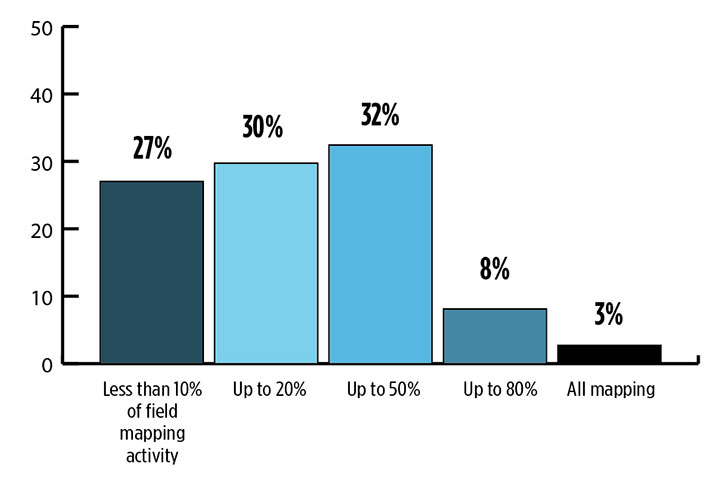


 Eagle Vision allows downloading and processing of unclassified commercial satellite imagery directly in the field, as the satellite passes overhead, supporting military leaders, even in remote areas and non-anticipated operations. Imagery provided by this system supports wartime operations, natural disaster and relief efforts as well as Homeland Defense preparations.


