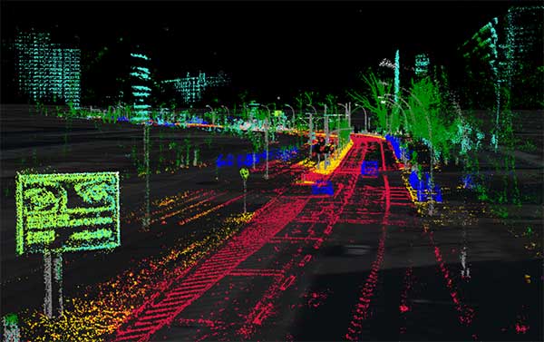
High-precision GPS, INS and computer vision come together in a single package called VINS to be demonstrated at the Auto.ai show in Berlin on Sept. 25-27.
Septentrio high-performance GPS/GNSS technology provides reliable absolute positioning inside this innovative computer vision localization system developed by Artisense, a company specializing in vehicle localization and 3D mapping solutions.
Septentrio, a manufacturer of high-accuracy GPS/GNSS technology for demanding applications, is providing positioning technology to Artisense, a supplier of computer vision solutions for automated vehicles.
Artisense incorporates Septentrio GPS/GNSS in their latest visual inertial navigation system (VINS), which will be demonstrated live at Auto.ai show in Berlin, Germany, on Sept. 25-27.
VINS combines computer vision, inertial sensors and GNSS (Global Navigation Satellite System) measurements to deliver highly accurate global 3D positioning and orientation information in any environment, even indoors.
“We are very pleased to work with Artisense on this technology and demonstrate how vehicle localization systems benefit from fusing computer vision with high-precision GNSS,” said Jan Van Hees, business development director at Septentrio. “The result of our cooperation is precise localization in any environment offering positioning reliability and redundancy needed for safety-critical applications such as autonomous vehicles or robotics.”
Multi-constellation, multi-frequency GNSS technology provides reliable centimeter-level global positioning to the VINS system with accuracy required for lane-level maneuvering and V2V warning systems.
Cameras and inertial sensors continue accurate localization as the vehicle moves into tunnels or parking garages with no line-of-sight to GNSS satellites.
Although the system uses a relatively simple MEMs IMU and off-the-shelf cameras, it delivers precision and reliability of a high-end INS system. “Positioning accuracy and reliability are very important to us. Earlier this year we have deployed a large-scale mapping operation in Berlin where we tested a lot of different GNSS receivers. We saw the best results coming from Septentrio consistently,” said Johannes Start, Technical Product Manager at Artisense. “We continue to use Septentrio receivers because they are precise, they acquire RTK (real-time kinematic) fix quickly and reliably and they are easy to integrate.”
The live demo at Auto.ai will offer a ride around Berlin in a car featuring VINS technology. One screen inside the car will continuously display the car’s location. Unlike the GPS of an average infotainment system, VINS will continue accurate localization anywhere, even in tunnels or in parking garages. The second screen inside the car will feature a real-time 3D point-cloud reconstruction of the car’s surroundings.
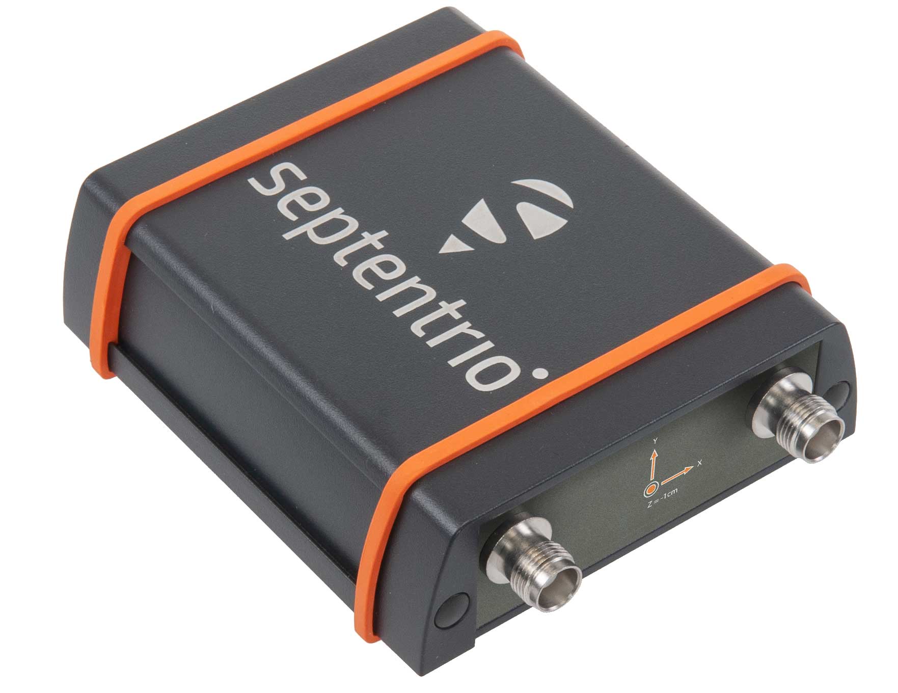
The AsteRX-SBi has a rugged housing, making it suitable for machine control and other outdoor uses. (Photo: Septentrio)
Septentrio has expanded its GNSS/INS portfolio with the AsteRx SBi, a new housed GNSS/INS receiver. The ruggedized AsteRx SBi fuses high-accuracy GPS/GNSS with a high-performance inertial sensor to provide reliable positioning and 3D orientation for machine control and logistic applications.
Within its rugged, waterproof enclosure, a high-performance GPS/GNSS is coupled with an industrial-grade inertial sensor to provide high-accuracy, reliable positioning and 3D orientation (heading, pitch, roll).
Offering the flexibility of either single or dual antenna, AsteRx SBi is designed for quick and easy integration into any machine monitoring or control system. AsteRx SBi packs performance and durability into a single, compact box. Reliable location and 3D orientation data is streamed with a high update rate and constant low latency.
“AsteRx SBi was designed with ease of integration and reliability in mind. Its compact, ruggedized housing is optimized for easy clamping to any machinery,” said Danilo Sabbatini, product manager at Septentrio. “It has all the features and tools needed for straightforward integration into machines or large robotic systems.”
Septentrio reliable centimeter-level positioning is based on true multi-frequency, multi-constellation GNSS (GPS, GLONASS, Galileo, BeiDou, QZSS) technology. AsteRx SBi combines GPS/GNSS and an industry-grade IMU (inertial measurement unit) to deliver precise positioning together with 3D attitude.
The AsteRx SBi is a robust positioning solution for machinery operating in environments challenging for GNSS. (Photo: Septentrio)
Septentrio’s unique GNSS–IMU integration algorithm enables continuous positioning in environments of low satellite visibility where short GNSS outages are possible. This is referred to as coasting or dead reckoning, and can happen near high structures, under bridges or under thick foliage. This makes AsteRx SBi a robust positioning solution for machinery operating in environments challenging for GNSS, such as in container yards, urban canyons or near cliffs.
AsteRx SBi comes with built-in Advanced Interference Mitigation (AIM+) technology. In busy urban environments electromagnetic waves can interfere with GPS and GNSS signals. AIM+ offers protection against such interference resulting in faster set-up times and robust continuous operation. A built-in power spectrum plot allows users to analyze interference, helping locate its source and mitigating it.
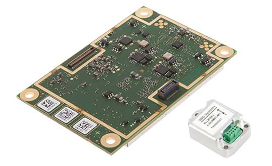
High-precision GPS/INS receiver is now available with a single-antenna option for faster integration, lighter weight and lower power consumption.
Photo: Septentrio
Septentrio’s GPS/INS receiver is now available with a single-antenna option. The single-antenna receiver brings the possibility of robust centimeter positioning and 3D attitude (heading, roll, pitch), while keeping weight and power consumption to a minimum. For Septentrio customers, this means simplified integration as well as increased operation time and productivity.
Septentrio centimeter-level positioning is based on multi-frequency, multi-constellation GNSS (GPS, GLONASS, Galileo, BeiDou, QZSS) technology. AsteRx-i S combines GNSS and an industry-grade inertial measurement unit (IMU) to deliver precise positioning together with 3D attitude and coasting functionality.
Septentrio’s unique GNSS/IMU integration algorithm enables continuous positioning in difficult environments such as near high structures, under foliage or during short GNSS outages (this is referred to as coasting or dead reckoning).
This makes AsteRx-i S a suitable positioning solution for robotics, autonomous vehicles and logistics. Previously available only as a dual-antenna product, AsteRx-i S is now available with either a single- or a dual-antenna option.
“By strengthening our GPS/INS integration portfolio we continue building upon our strategy of bringing reliable precise positioning together with 3D attitude to challenging industrial environments such as container parks or tree plantations,” said Danilo Sabbatini, product manager at Septentrio.
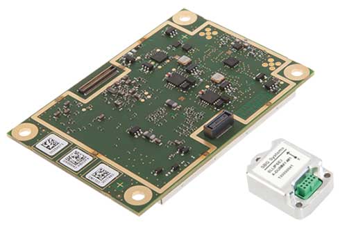
“AsteRx-i S has now become even more versatile with the support of both single and dual antenna operations on the same hardware platform,” Sabbatini said. “With the single-antenna AsteRx-i S delivers accurate 3D attitude in small-size applications where weight and power consumption are critical, while the dual antenna option is still the best solution for applications requiring short initialization time.”
Small, light, low power. The single-antenna AsteRx-i S requires minimal space which makes it suitable for robotic devices looking for small and light precise positioning solutions. Since only one antenna is required, there is less weight and lower power consumption, resulting in extended battery life. The dual antenna AsteRx-i S, on the other hand, is the best solution for devices requiring quick heading initialization and devices with prolonged static operation.
Advanced Interference Mitigation. AsteRx-i S comes with built-in Advanced Interference Mitigation (AIM+) technology. In robotic devices neighboring electronics can emit electromagnetic radiation which interfere with GNSS signals. AIM+ offers protection against such interference resulting in faster set-up times and robust continuous operation. A built-in power spectrum plot allows users to analyze interference, helping locate its source and mitigating it.
By offering both single and dual antenna options, Septentrio is now able to better accommodate specific needs of their customers interested in a GNSS/INS solution.
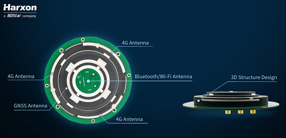
Architecture of the X-Survey antenna. (Image: Harxon)
Blocking interference
Interference can be blocked at the data-collection stage, using an advanced antenna.
Harxon’s X-Survey is a compact high-precision GNSS antenna. It provides superior navigation and communication performance in surveying applications. A frontal band-pass filter setting effectively rejects out-of-band signals before they enter the low-noise amplifier of the antenna for signal augmentation.
Meanwhile, the filter itself has insertion loss, making a low insertion loss filter a prerequisite for optimal system noise reduction. To avoid this situation, X-Survey employs ceramic filter with low signal loss and in-band flatness to significantly improve system anti-interference capability and ensure reliable signal receiving.
The mosaic module provides AIM+ mitigation technology. (Image: Septentrio)
Septentrio began to tackle the interference problem more than 20 years go, designing and manufacturing high-precision GNSS receiver technology with emphasis on reliability and robustness. The result is Advanced Interference Monitoring and Mitigation (AIM+) technology which secures the company’s GNSS receivers against jamming and spoofing interference. AIM+ has recently been upgraded with an extended anti-spoofing functionality.
Building on its existing spoofing detection, Septentrio has developed a new anti-spoofing algorithm for its commercial receivers. The algorithm leverages Galileo Open Service Navigation Message Authentication (OSNMA) for spoofing resistance. It was developed in the framework of the GSA FANTASTIC project with the goal of improving the security of timing in critical infrastructure.
Mobile devices and cloud applications increasingly rely on GNSS technology used by telecom companies. Having secure and robust GNSS receivers in telecom infrastructure is key to reliable mobile and positioning services.
Alternative signals
Prototype design of the PNT-5500. (Image: Jackson Labs)
A new reference receiver, Jackson Labs’ PNT-5500, includes a custom Satelles/Iridium (STL) and GPS receiver, and an optional Edge Grandmaster/PTP1588 capability.
Using STL signals received directly through a small antenna mounted on the device, the PNT-5500 provides nanosecond timing synchronization in GPS-challenged environments, including deep indoors (no rooftop antenna required). It provides secure timing during GPS jamming and spoofing events. The unit is designed for high-volume, low-cost telecom small-cell synchronization, and is optionally available with holdover oscillators such as DOCXO and CSAC atomic clocks.
While GPS is vulnerable to jamming and spoofing, the PNT-5500 uses the Iridium infrastructure to provide assured timing that is impervious to spoofing and provides 1,000X higher signal strength compared to GPS, producing jamming resilience and deep-indoor reception. The system is designed to be fully interoperable with legacy equipment, for a low-cost, fully-deployed Assured PNT capability alternative to GNSS today.
Assessing vulnerability
Image: Qascom
Qascom offers several robust PNT services and products, including vulnerability assessment, robust navigation and interference localization.
Vulnerability assessment is the key proactive measure, using cutting-edge signal generators to design and test tomorrow’s receivers. For example, Qascom’s QA707 GNSS simulator tests receivers against emerging jamming and spoofing threats, allowing OEMs to discover in advance any potential vulnerability that may affect the availability and the integrity of the signal.
Robust navigation is supported by advanced mitigation algorithms, equipped with pre and post-correlation algorithms, as well as the inclusion of sensor fusion and dead-reckoning features.
Qascom’s attack detection products include external monitoring networks that support GNSS receivers. These networks provide an accurate perception of the operational environment, allowing threat characterization, classification and forecast. For instance, Qascom’s QB100 enables the simultaneous threat detection and localization by means of a monitoring cluster that delivers 24/7 situational awareness to a set of target receivers within the protection area.
Reliable timing
Meinberg provides GNSS timing solutions for nearly every application type. Its reliable systems are based on firmware built from the ground up by an in-house team of expert engineers. All Meinberg firmware is constantly checked and updated to ensure it adapts to evolving industry standards.
The company’s synchronization systems use a built-in Meinberg GPS receiver or combined GPS/GLONASS clock. They also support a broad range of reference time sources, including 1 PPS, 10 MHz, inter-range instrumentation group time codes (both direct current level shift and amplitude modulated), or network time protocol (NTP) servers. This redundancy in synchronization sources means Meinberg’s systems are protected against a loss of signal. Furthermore, to ensure the correctness of the reference time and date, an intuitive Secure Hybrid System (SHS) feature includes an independent secondary clock for enhanced plausibility checks.
For superior holdover performance, the Meinberg XHERB (with one or two Rubidium modules from Stanford Research) can be added to the Meinberg Intelligent Modular Synchronization (IMS) time and frequency systems. If the reference clock loses its sync source, the XHE chassis will provide the sync reference for the IMS chassis based on its holdover performance.
Mosaic is Septentrio’s most compact, next-generation, high-precision multi-frequency GPS/GNSS module. The receiver brings precision and reliability of high-end multi-frequency GNSS to mass-market applications, the company said. It is designed to fit into the assembly-line process, which allows mosaic to be favorably priced for high volumes.
Its lightweight and low power consumption helps extend the battery life of robotic devices, increasing operation time and efficiency. This makes mosaic suitable for applications such as robotics, automation, telematics and wearables.
“We see a growing demand for reliable high-precision positioning,” said Chris Lowet, product manager at Septentrio. “A few years ago, this demand was concentrated in professional applications, for example survey, high-precision mapping and machine control. Today, with expansion of robotics, automation and IoT, a wide range of devices need high-precision positioning, from ag robots to IoT gateways to autonomous vehicles. We designed mosaic to answer these market needs.”
Highlights of mosaic include:
Centimeter positioning in tough environments with multi-frequency, multi-constellation GNSS technology
Extensive corrections support for high-accuracy positioning: SBAS, PPP, SSR, RTK
RAIM+, integrity engine needed for safety-critical applications such as autonomous vehicles
Tracking all current and future GNSS satellite signals for enhanced real-time kinematic (RTK) performance and guaranteed RTK network compatibility
100-Hz update rate, suitable for robotics and fast-moving vehicles.
The development kit assists Septentrio customers with integrating mosaic into their system. It supports connectivity through internet, COM ports, USB 2.0 as well as an SD Card slot. The development kit can be requested here.
Welcome to Part 2 of our coverage of the mammoth AUVSI Xponential 2019 show in Chicago, which drew 8,000 attendees, featured 300+ speakers on its technical program, and furnished a temporary home for more than 800 exhibitors. It was “Everything Unmanned” and a challenge to cover. Last month we looked primarily at new vehicles. This month’s column focuses on sensors, capabilities and apps aboard those and other airborne drones — and even an anti-drone drone!
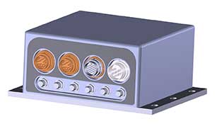
Sagetech: For UAVs to gain entry to the US National Airspace System (NAS) and to other controlled airspace all around the world, sense-and-avoid capability is paramount. Sagetech comes from the world of Mode-S transponders, with which the majority of piloted aircraft are equipped. These devices transmit aircraft identification and provide the moving IDs on air-traffic controller display monitors. In the military sector, Identification Friend or Foe (IFF) interrogator-transponders enable similarly equipped aircraft of NATO countries to determine which are friendly aircraft within their immediate airspace, and which are not.
The MX12B Mode 5 IFF with FAA-certified civil modes. (Photo: Sagetech)
Sagetech has just released a micro-mode 5 MX12B aviation transponder that enables small unmanned aircraft to interoperate within NATO airborne units. The transponders weigh around 10lb, so mil-spec UAVs operating in NATO airspace can now also carry this light-weight unit.
For civilian UAVs, GPS has been added to provide aircraft position outputs in Automatic Dependent Surveillance Broadcast (ADS–B) message format, allowing other aircraft and UAVs to receive a vehicle’s location. The Sagetech ADS-B transponder is small, certified to Federal Aviation Administration (FAA) standards (TSO C-166b) and is affordable. Boeing Scan-Eagle UAVs apparently already carry Sagetech transponder capability.
The tailBeacon ADS-B retrofit. (Photo: uAvionics)
uAvionix: Another avionics supplier has brought out certified ADS-B capable transponders, but with a novel way to add the required capability to general aviation (GA) aircraft, typically smaller private planes. The FAA has mandated that all aircraft should be fitted with ADS-B capability by January 1, 2020 in order to fly within controlled airspace, so uAvionix has simplified ADS-B retrofit for older GA aircraft.
All aircraft have wingtip and/or rear-tail beacon lights; this update replaces their existing beacon with a light which also includes ADS-B capability when paired with the aircraft transponder.
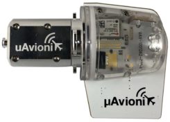
The FYXnav TSO CERTIFIED GPS navigation source. (Photo: uAvionics)
uAvionix also supplies a couple of GPS sensors for external mounting on UAVs: the FYXnav sensor is FAA-certified to TSO-C199 Traffic Awareness Beacon System Class B.
Sensefly released a new inspection application for their eBeeX UAV, specifically designed for solar farms. With a dual thermal/video sensor for data collection and data processing using application-specific Raptor Maps software, Sensefly claims to reduce the inspection time required for a 150MW solar farm to around 1 day, a 300-times improvement on ground inspection using a hand-held thermographic sensor.
Provided an inspection operation could support five 70-minute eBee-X flights during one day, the UAV could over-fly up to 161 acres of solar panels at an altitude of 138ft, gathering anomalies during each flight. This adds up to 150MW of solar panels over the 5 flights. Sensefly claims this to be twice as fast as with multi-rotor dones. The Raptor Maps software then generates an inspection report identifying each anomaly, using the eBee X’s video and thermal imagery to identify, classify, and localize the detected problems.
The Fortem DroneHunter intercept drone. (Photo: Fortem)
Fortem makes an anti-drone defense combining a radar detection system with a DroneHunter drone that attacks other UAVs, releasing an 80ft net to capture intruders. For those nefarious drones which are hardened against RF countermeasures, this system is also touted as capable of recovering the offending drone without damage, returning it to the operator in a net at the end of a tether. The DroneHunter flies autonomously on its intercept mission, carrying a compact radar system integrated with a ballistic net release system.
Septentrio continued promotion of its Mosaic chip-level GNSS at Xponential. The new chip uses the same proven core DSP with a new RF front-end and a new processor, working with more than 30 signals from the existing six GNSS constellations, and with L-band and satellite-based augmentation systems (SBAS).
The chip appears to be aimed at the high-precision market, replacing the AsteRx-m2 board level receiver family.
The chip runs Septentrio RTK algorithms, is quite small (1.29 x 1.29 x 0.15 in), is designed for high-volume surface mount manufacture, and comes with a set of popular interfaces. The chip is sampling now, with production planned for later this year.
NovAtel is growing, opening new offices in the US and needing more local real-estate to fit its headquarters in Calgary, Canada. The company is now part of Hexagon Positioning Intelligence (Hexagon PI), a partial re-branding that includes VERIPOS correction services and recently purchased AutonomousStuff, specializing in ground vehicles. Each organization still operates individually through its own brands. On the NovAtel booth, existing products were presented through a number of new applications, including those of the growing mil-spec products group.
Summary. While AUVSI Xponential was over in early May, the companies who were there have not rested. All are developing new approaches for UAVs and unmanned ground vehicles, sensor systems for even wider applications than seen in Chicago, and all manner of other added capabilities. This business only gets bigger and more innovative.
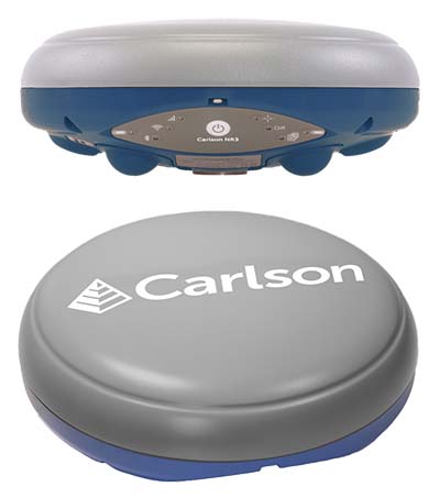
Carlson Software has introduced a new four-constellation, three-frequency surveying receiver. The Carlson NR3 network rover weighs just under two pounds, but delivers highly reliable GNSS real-time kinematic (RTK) for land surveying, geospatial information systems (GIS) and other data-collection uses.
Carlson Software President and Founder Bruce Carlson introduced the Carlson NR3 network rover at the company’s Grow With Us User Conference 2019.
Able to be used as a base or rover, the NR3 uses all four constellations — GPS, GLONASS, BeiDou and Galileo — and provides triple-frequency tracking on GPS, GlONASS and Galileo, the company said.
Incorporating multipath and ionospheric detection, the NR3 maintains accuracy and continued operation despite shocks, vibration or other interference.
According to the company, the NR3 is easy to mount and balance as it utilizes the optional Hybrid+ in Carlson SurvCE/PC that enables simultaneous interaction with GNSS and a robotic total station, the company said.
”The NR3 is Carlson’s answer for a lightweight – just 1.8 lbs. – network rover that can also be used in a base rover setup with Carlson’s Listen-Listen service,” said Butch Herter, Carlson’s director of Hardware Development. The Listen-Listen service allows base/rover operations via cellular modem for better correction transmission ranges compared to traditional terrestrial UHF radios.
“It has hot swappable batteries and four come with the system that give it over a 20-hour runtime,” Herter added. “With the dual internal cell modem antennas, it maintains cell signal where others may not. When paired up with the Carlson CR2+ robot, it is the ideal companion receiver to use with the new SurvCE hybrid surveying system.”
Produced by Septentrio with Carlson specifications, the Carlson NR3 has an integrated 4G LTE cellular modem, plus Wi-Fi and Bluetooth for modern wireless capabilities and is made to perform exceptionally in locations with bad visibility or interference.
Recent years have seen an increase in drivers turning to cheap GNSS jamming devices in order to move around undetected or to thwart built-in anti-theft systems or road tolling systems. These jammers not only knock out their own GNSS receiver, they also block GNSS signal reception in a radius of several hundred of meters.There is a growing demand for automatic detection of these illegal jammers to help catching the offending driver.
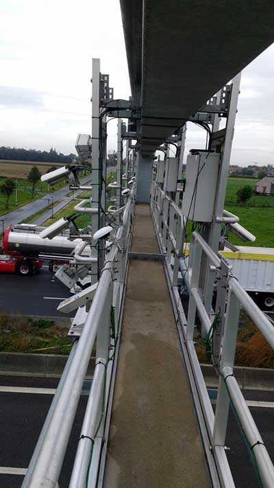
Septentrio GNSS antenna placement on highway gantry. (Photo: Septentrio)
An ION GNSS+ 2018 presentation by Wim de Wilde and Jean-Marie Sleewaegen presentation showed how a multi-antenna GNSS receiver with built-in RF spectrum monitor and adequate processing tool can efficiently detect and classify jamming events and identify the offending car or truck. They conducted a five-day test with two Septentrio AsteRx-U dual-antenna receivers installed on an overhead structure above a busy highway.
In parallel to the GNSS tracking and built-in anti-jam functionality, the AsteRx-U can simultaneously sample the RF signal from its two antennas. One of the objectives of the test was to evaluate the possibility to perform lane detection by cross-correlating the jamming signal received by the two antennas. In addition, the antennas were mounted with a significant inclination angle to create an asymmetrical reception pattern.
The goal was to assess the feasibility of detecting the driving direction from the time series of the received jammer power. Such lane or direction detection would greatly help identifying the offending driver in heavy traffic conditions when more than one vehicle crosses the overhead structure at the time of the jamming.
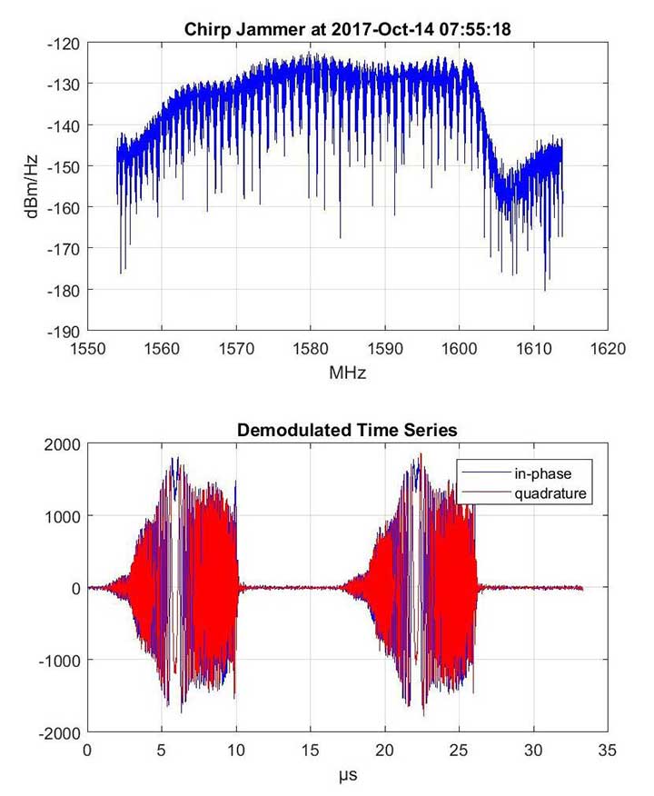
Over the five days of the experiment, 45 jamming events were recorded and analyzed, most of them intentional: continuous wave, chirp or even less-known pulse jammers.
Chirp jammer example. (Charts: Septentrio)
The researchers explained how the jamming events are automatically detected and classified by the processing tool, using pattern recognition to distinguish between intentional harmful events and unintentional interferences. They presented selected cases illustrating the RF signature of the most prevailing types of jammer.
They then addressed the direction and lane sensing algorithm and discussed the effect of multipath propagation of the jammer signal. All algorithms are illustrated with real-life examples.
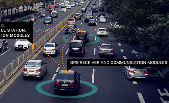
Belgium has launched its first smart highway test environment. Septentrio GPS/GNSS receivers are integrated into vehicles and infrastructure to provide dependable, high-accuracy positioning and to aid sensor fusion in driverless navigation and truck platooning.
Septentrio’s high-precision GPS/GNSS technology will be one of the key components in a Smart Highway system, which launched April 8 with a live demonstration in Antwerp, Belgium. A section of a highway will be dedicated as a test environment for technology which prepares Belgium for automated driving and truck platooning.
When vehicles are aware of each other’s position and velocity, road efficiency and safety can be significantly improved by smoothing traffic flow and automatically breaking if slowing traffic is detected ahead.
Roadside units along the highway will feature GNSS receivers acting as reference stations, sending out continuous positioning corrections. Onboard GNSS units will use these corrections together with built-in quality indicators to calculate trustworthy, sub-decimeter positioning. They will also provide precise timing for syncing the multitude of sensors onboard these “smart vehicles.”
“We are excited to be a part of the Smart Highway testbed which is aimed at improving road safety and traffic flow,” said Jan Van Hees, business development director at Septentrio. “The automotive ecosystem is undergoing a shift towards automation enabled by the latest technology in communications, sensors and precise positioning. Our role in this project builds upon our strategy to continue providing high-accuracy, reliable positioning solutions aimed at the automotive industry.”
The Advanced Interference Mitigation (AIM+) technology shields Septentrio receivers from interference. On a highway, an increasing number of trucks are equipped with illegal jamming devices to avoid road tolling. These jamming devices can interfere with GPS signals used by other vehicles and infrastructure.
Smart Highway is a project of the Flemish government coordinated by imec, a world-renowned research and innovation hub of nano-electronics and digital technology. Septentrio, Toyota, Ericsson and Telenet are contributing industry partners for the project, while UAntwerpen, UGent and others are research partners.
On the European level, the CONCORDA project supports research and development of automated vehicle technology and infrastructure in Germany, Spain, France, Netherlands and Belgium.
Are drones (UAVs) a disruptive or constructive technology for high-precision mapping that yields practical, actionable results for the end user/customer?
Ismael Colomina
“More constructive than disruptive. Drone mapping is opening new markets that, to a large extent, were not serviceable by conventional manned flights. On the other hand, the profound changes — and crisis — in the mapping business were not produced by drones.” Ismael Colomina GeoNumerics
Jean-Marie Sleewaegen
“Drones have dramatically reshaped the surveying and mapping industry. Combined with reliable positioning and recent advancements in high-resolution cameras, photogrammetry and computer vision, drones now enable high-accuracy mapping faster and at much lower cost than conventional mapping techniques.” Jean-Marie Sleewaegen Septentrio
Jules McNeff
“Drones can be constructive augmentations to high-precision map products because of their ready access to diverse locations. Drone imagery can document real-time physical changes that affect mapping applications during natural disasters or other events — but images alone aren’t maps without a geo-referenced grid such as the U.S. National Grid.” Jules McNeff Overlook Systems Technologies Inc.
Other members of the EAB
Tony Agresta Nearmap
Miguel Amor Hexagon Positioning Intelligence
Thibault Bonnevie SBG Systems
Alison Brown NAVSYS Corporation
Clem Driscoll C.J. Driscoll & Associates
John Fischer Orolia
Ellen Hall Spirent Federal Systems
Terry Moore University of Nottingham
Bradford W. Parkinson Stanford Center for Position,Navigation and Time
Septentrio, a high-precision GNSS company, and Sapcorda, a specialist in GNSS correction services, will conduct a live demonstration of a safe, high-accuracy positioning and correction solution for automated driving.
“We are running the demonstration during the course of this week just south of Las Vegas city center,” Neil Vacans told GPS World. Vacans is Septentrio’s vice president of global Sales. The demonstration is taking place in Las Vegas during the Consumer Electronics Show, being held Jan. 8-11.
Sapcorda and Septentrio have put together a solution that is ready for demonstration in Europe and North America.
The companies have combined their respective technologies to deliver the benefits of SSR (space state representation) technology seamlessly to OEM automakers and Tier 1 integrators. These benefits include decimeter-accuracy within seconds, anywhere over an entire continent, to support autonomy levels from lane keeping to full autonomy in a totally homogeneous coverage, the companies said.
The GNSS augmentation service is scalable through simple broadcast corrections, and safety-awareness is provided via Sapcorda’s integrity concept and Septentrio’s integrity monitoring engine.
In December 2018, Septentrio announced its mosaic compact multi-constellation GNSS receiver SiP (system-in-package) module, available in 2019. The Septentrio mosaic, a multi-band, multi-constellation receiver in a low-power surface-mount module with a wide array of interfaces, is designed for mass-market applications like robotics and autonomous systems. The mosaic module integrates the latest GNSS and RF ASIC technology, as well as the robust positioning engine from Septentrio.
All Septentrio GNSS receivers and modules feature AIM+ technology, an advanced on-board interference mitigation commercially available. Septentrio GNSS receivers can suppress the widest variety of interferers, from simple continuous narrowband signals to the most complex wideband and pulsed jammers.
“We are excited to be able to provide live demonstrations of Sapcorda’s safe and precise correction service especially designed for autonomous driving,” said Jan Van Hees, business development director at Septentrio. “Sapcorda provides a unique high-precision GNSS correction service designed for fast, homogeneous accuracy at continental coverage, thus ideal for autonomous and mass market applications.”
“Septentrio specializes in high-precision and high reliability GNSS positioning for a variety of industrial and commercial markets,” said Goran Jedrejčić, business development manager at Sapcorda. “They have developed a range of technologies, including unique jamming robustness and integrity positioning to support safety-sensitive applications in various challenging environments. Combining this with our safety-centered correction service, it is a unique solution for developers of autonomous driving systems.”
“With fast and efficient implementation of Sapcorda SSR-based correction service into Septentrio’s GNSS-platform, we were able to demonstrate the efficiency of the technology for automotive use in a robust & highly efficient way,” confirmed Jedrejčić. “Septentrio offers a unique blend of GNSS-based technologies and is an ideal partner for both traditional and new markets, with growing demand for high-precision positioning.”
Septentrio has teamed up with Point One Navigation, a provider of precise location as a service, for autonomous vehicle demonstrations during the 2019 International Consumer Electronics Show, which will take place Jan. 8-11 in Las Vegas. During the conference, invitees will be able to ride in a fully autonomous demonstration vehicle that incorporates technology from both companies, as well as meet directly with technical experts, reports GIM International.
During the demonstration, Point One Navigation will showcase its proof-of-concept autonomous vehicle equipped with the the FusionEngine vehicle localization software. According to the company, demonstrations will utilize corrections from Point One’s Polaris Cloud, a new correction network that enables high-precision GPS and computer vision-based localization, while allowing the customer to choose the performance and price point that best fits their application.
According to GIM International, Point One’s solution is powered by Septentrio’s GNSS receivers. For accurate positioning of autonomous vehicles, Septentrio utilizes at least two frequencies broadcast by each GNSS constellation (BeiDou, Galileo, GLONASS, GPS, QZSS), the companies said.
For users operating in open sky scenarios, a Septentrio RTK receiver can be used directly with Polaris Cloud to provide centimeter-level accuracy.
Point One Navigation has chosen to work with Septentrio to power its solutions for both the correction network and our FusionEngine reference design because of the excellent quality, robustness and jamming resistance of their GNSS receiver technology, said Aaron Nathan, CEO and co-founder of Point One Navigation.