Tag: Septentrio

  • Septentrio launches AsteRx SB compact, ruggedized GNSS receiver

    Septentrio launches AsteRx SB compact, ruggedized GNSS receiver

    Photo: Septentrio
    Photo: Septentrio

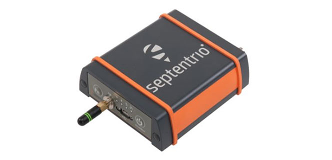
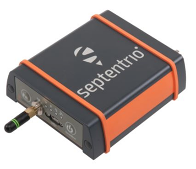
    GNSS receiver manufacturer Septentrio is introducing its AsteRx SB at two industry shows: Expomin in Santiago, Chile (April 23-27), and Intermat in Paris, France.

    According to the company, the AsteRx SB delivers Septentrio’s quad-constellation real-time kinematic (RTK) positioning in a low-power, IP68 compliant housing. Built around the AsteRx-m2 GNSS receiver engine, the AsteRx SB features Wi-Fi, Bluetooth, USB, Ethernet and serial connectivity.

    Septentrio’s GNSS+ suite of positioning algorithms converts difficult environments into good positioning: LOCK+ technology to maintain tracking during heavy vibration, APME+ to combat multipath, and IONO+ technology to ensure position accuracy during periods of elevated ionospheric activity.

    The AsteRx SB also features the AIM+ interference mitigation and monitoring system, which can suppress the widest variety of interferers, from simple continuous narrowband signals to the most complex wideband and pulsed jammers.


    Key benefits for users:

    • Quad-constellation, multi-frequency, all-in-view RTK receiver
    • Robust and compact IP68 weatherproof housing
    • AIM+ interference monitoring and mitigation system
    • L-band PPP, RTK, scalable accuracy
    • High-update rate, low-latency positioning
    • Base and rover operation
    • Bluetooth, Wi-Fi, Ethernet, serial and USB communications

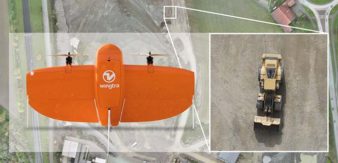
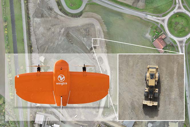
    Whether exposed to the elements or inside a vehicle cab, operating alone or as a core component of a sensor-fusion system, the AsteRx SB is straight-forward to set up and integrate into any new or existing application. Using Wi-Fi or micro USB, the AsteRx SB can be configured and monitored using any device with a web browser.


    “We believe the AsteRx SB is the best all-rounder on the market today. We’ve produced a small and low-power device with zero compromise on performance,” said Gustavo Lopez, product manager at Septentrio. “From machine control to sensor-fusion applications, manned or unmanned, the compact size and low power of the AsteRx SB along with its range of communications options make it ideal for any project requiring reliable high-precision positioning.”

    At Intermat in Paris, Septentrio will exhibit at Booth 6H-041 and at Expomin in Santiago, Chile, at Booth 1K-30.

  • Septentrio to supply GNSS boards for WingtraOne mapping drone

    Septentrio to supply GNSS boards for WingtraOne mapping drone

    Belgian GNSS receiver manufacturer Septentrio was selected by Swiss drone manufacturer Wingtra to supply GNSS OEM receiver boards and PPK processing software for the recently-launched WingtraOne PPK drone.

    The combination of vertical take-off and landing (VTOL) technology and a high-spec post-process kinematics (PPK) brings wide-area coverage at ultra-high precision.

    Following a flight, the GNSS data of the WingtraOne is processed offline using Septentrio’s PPK software. This combines the drone data with correction data from a nearby reference receiver to get accurate cm-level geolocations for every photograph.

    The on-board high-resolution Sony RX1RII camera, AsteRx-m2 UAS receiver board combined with Septentrio’s PPK library, and Pix4D photogrammetry processing software are together able to produce ground precisions of 1.3 centimeter (cm) horizontal and 2.3 cm vertical.

    Image: Wingtra
    Image: Wingtra

    “With the WingtraOne PPK, we can offer a world first in drone photogrammetry — wide coverage at ultra-high precision,” said Armin Ambühl, CTO of Wingtra. “In a single one-hour flight, the WingtraOne can cover 130 ha (320 acres) delivering mapping with GSDs [ground sample distance] below 1 cm/pixel with absolute accuracy down to 1.27 cm.”

    He continued, “WingtraOne’s advantage is twofold: it combines VTOL with the latest PPK technology from Septentrio. With VTOL we can offer the best of both worlds: multirotors and fixed-wings. Vertical take-off and landing means hands-free operation and a smoother ride for the on-board camera payload. Secondly, efficient flying in fixed-wing mode means far greater coverage than any comparable multirotor.”

    “We are proud and excited to be part of this innovative project with Wingtra pushing the boundaries of aerial photogrammetry,” said Gustavo Lopez, product manager at Septentrio. “The WingtraOne incorporates our AsteRx-m2 UAS OEM board and, photogrammetry applications requiring high-precision, low-latency positioning are what it does best. The board is specifically designed for quick and easy integration and, with Septentrio’s world-first, multi-frequency PPK, cm-level precision can now reach the parts dual-constellation solutions feared to tread.”

  • Airobot locates containers at largest European terminal

    A Belgian container terminal is about to become Europe’s largest, and GNSS technoloy will be integrated.

    The MSC PSA European Terminal (MPET) in Antwerp, Belgium, is moving its operations from the Delwaidedock on the right bank of the river Schelde to the Deurganckdock on the left bank.

    The move is part of an expansion of its capacity of 9 million TEUs annually. TEUs are a 20-foot equivalent unit, a term used to describe the capacity of container ships and container terminals.

    When fully moved and operational, the left bank terminal will feature a total of 41 quay cranes across 10 berths, 200 straddle carriers and a quay length of 3,550 meters.

    “For this project, we were looking for a positioning solution that was compatible with the solution that has been in use on the terminal since 2008,” said Douwe Witteveen, senior project manager at PSA MPET. “We need to accurately know where every container is picked up and dropped off without interfering with the actions of the driver. “Based on sensors in the vehicle, the GNSS unit must detect a pick-up or drop-off and provide a position to our system. Unfortunately, the receivers used previously were no longer available, so we needed to find someone who could make a new custom integration fast.”

    Multipath mitigation copes with GNSS reflections caused by metal cargo containers. (Photo: Airobot)

    Airobot was selected by MPET to create a solution, and did so in less than four months, said Jan Leyssens, managing director at Airobot.

    The SC-PSA-GNSS unit integrates the AsteRx-m GNSS receiver from Septentrio NV and uses EGNOS to provide submeter accurate positions. The receiver has multipath mitigation technology on board to cope with the many GNSS reflections caused by all the metal containers, and combines GPS and GLONASS to provide a solution close to the quay cranes.

    “We started discussions about the requirements in January and have delivered 100 units in less than four months’ time,” Leyssens said. “Fortunately, we have a lot of experience integrating GNSS technology into our drone solutions, so we could act fast. We also listened to the people in the field to make sure the unit is easy to install and existing cable installations could be used.”

    “We believed that the know-how and expertise of the Airobot team could help us to get a solution fast, and they delivered what they promised,” said Douwe.

  • Septentrio launches AsteRx-m2a, AsteRx-m2a UAS boards

    Septentrio launches AsteRx-m2a, AsteRx-m2a UAS boards

    Septentrio debuted the AsteRx-m2a and AsteRx-m2a UAS GNSS OEM engines at Commercial UAV 2017, held Oct. 24-26 in Las Vegas.

    The two new OEM boards provide precise and reliable multi-frequency, all-in-view real-time kinematic (RTK) positioning and heading — along with interference technology — with low power consumption, the company said.

    Both boards are smaller than a credit card and feature Septentrio’s AIM+ interference mitigation and monitoring system. AIM+ can suppress a wide variety of interferers, from simple continuous narrowband signals to the most complex wideband and pulsed jammers.

    The AsteRx-m2a board by Septentrio. Photo: Septentrio

    Increasing levels of radio-frequency pollution, coupled with the intrinsic danger of self-interference in compact systems such as UAS, makes interference mitigation a vital element in any UAS system that uses GNSS positioning.

    Both boards are designed to bring high-precision positioning and attitude to any space-constrained application. According to the company, both receivers are designed to serve as core components in any multi-sensor application.

    The AsteRx-m2a UAS is aimed specifically at unmanned applications, bringing plug-and-play compatibility for autopilot systems such as ArduPilot and Pixhawk. Event markers accurately synchronize camera shutter events with GNSS time. The board can be powered directly from the vehicle power bus via its wide-range input.

    The AsteRx-m2 UAS board by Septentrio. Photo: Septentrio

    The AsteRx-m2a UAS works seamlessly with GeoTagZ software, providing offline re-processed RTK accuracy without the need for either ground control points or a real-time datalink.

    “We’ve taken the hugely successful AsteRx-m2 and added a second antenna input for high-precision GNSS heading,” said Gustavo Lopez, OEM product manager at Septentrio. “No need to manoeuvre around in a figure of ‘8’ trying to initialise INS heading or find space or additional power for a separate INS module now. All you need is a second antenna and you’re good to go.”

    Septentrio is located at booth 206 of Commercial UAV Expo 2017.

  • Septentrio debuts smart antenna at Intergeo 2017

    Septentrio’s debuted its Altus NR3 at Intergeo 2017, which took place Sept. 26-28 in Berlin, Germany. According to the company, the Altus NR3 combines easy-to-use, multi-frequency, quad-constellation RTK with an unrivalled communications toolset.

    Key features of the antenna include a light and portable GNSS receiver; quad-constellation, multi-frequency RTK positioning; and an anti-jamming and monitoring system. The Altus NR3 also features all-in-one base and rover operation.

    “This is a true RTK system that makes the use of all the signals to have the best performance that Septentrio is recognized for,” said Gustavo Lopez, product manager at Septentrio. “We also bring something that is quite unique in terms of technology, which is interference mitigation.”

    According to the company, the Altus NR3 can suppress the widest variety of interferers from simple continuous narrow-band signals to the more complex wide band and pulsed transmitters, as well as lnmarsat and Iridium satellite transmissions.

    The Altus NR3 also features an open interface, so it can be used for a variety of use cases and applications, Lopez added.

    Watch the video to learn more about the Altus NR3’s features.

  • Septentrio unveils Altus NR3 at Intergeo 2017


    At Intergeo 2017, Septentrio debuted the Altus NR3: a multi-frequency, quad-constellation (GPS, GLONASS, BeiDou and Galileo) RTK receiver for survey and GIS applications.

    The Altus NR3 features Septentrio’s AIM+ interference mitigation and monitoring system, allowing continued operation in the presence of both intentional and non-intentional interference. According to the company, it combines advanced GNSS features with a robust communications suite in a compact, low-power and easy-to-use unit.

    The Altus NR3 is configurable as either a rover or a base station. It offers one-touch logging and Septentrio’s on-board web interface so users can monitor and configure the unit as well as collect data using any Wi-Fi-capable device.

    Data collection is done using either SurvCE or Septentrio’s PinPoint Data Collector with data updating to the cloud. Septentrio’s open interface and fully documented data formats are widely supported, making the Altus NR3 easy to integrate into any existing workflow, the company said.

    “We’ve built on the flexibility, reliability and ease-of-use that our Altus line is famous for, and we’ve added all-in-view RTK and the most the most advanced interference mitigation system on the market today,” said Gustavo Lopez, product manager at Septentrio. “Locations with bad visibility or at risk of interference that were previously off limits can now benefit from high-precision GNSS positioning, saving both time and cost.”

  • GeoCue’s GNSS kit for drones provides survey-level accuracy

    GeoCue’s GNSS kit for drones provides survey-level accuracy

    GeoCue Group has released a GNSS positioning system that will allow users of DJI Phantom 4 Pros and Inspire 2 drones, as well as most drones using higher end cameras, to achieve survey-level accuracy with minimum ground control.

    Loki, GeoCue’s new direct geopositioning system for small unmanned aerial systems, solves the two fundamental problems associated with this technology:

    • Positioning Accuracy. Loki uses the new AsteRx-m2 multi-frequency, multi-constellation GNSS engine from Septentrio, which has 448 hardware channels.
    • Camera Events. GeoCue has invented a patent-pending method of detecting camera events from Phantoms/Inspires and synchronizing those events to GNSS positioning. No modifications to the drone are necessary; the adapter cable is “plug and play.”
    GeoCue’s Loki positioning kit uses the Septentrio AsteRx-m2 GNSS engine.

    Loki is a self-contained kit that provides all of the hardware and software needed to equip a drone with a post-processed kinematic (PPK) multifrequency, multi-constellation, differential, carrier-phase GNSS.

    Using a local base station (not included), Loki provides centimeter-level positioning with minimal, and in some cases, no ground-control points (though GCPs are always recommended for quality assurance).

    “GeoCue has been a long-time Septentrio OEM development partner,” said Neil Vancans, vice president of Septentrio Americas. “They have offered our previous generation sUAS board on their high-end AV-900, achieving remarkable results in both accuracy and reliability. By solving the problem of connecting the virtual camera trigger on DJI drones to our AsteRx-m2 GNSS engine, they can achieve professional mapping accuracies with consumer-grade UAVs.”

    DroneDeploy of San Francisco has become a leader in cloud-based processing for DJI, as well as other drones. DroneDeploy has enabled users of Phantom and Inspire drones to easily upload drone images, work online with analytics, and download point clouds and orthophotos to desktops for advanced processing.

    Without Loki, achieving acceptable network accuracy requires the time-consuming placement of ground-control targets throughout the mapping site.

    GeoCue and DroneDeploy have been working together to ensure a smooth Loki-DroneDeploy workflow from field to finish.

    “The GeoCue Loki system is an exciting product for anyone using drones to make maps with high accuracy,” said Mike Winn, CEO and co-founder of DroneDeploy. “The Loki’s combination of high-end GNSS positioning and DJI camera synchronization enables survey-grade accuracy with the simplest workflow that we’ve seen — making the Loki a great fit for the DroneDeploy platform.”

    “I am very excited to be working with industry leaders such as DroneDeploy on our Loki project,” said Lewis Graham, president and CTO of GeoCue Group. “Loki provides high accuracy positional data to downstream processing solutions. More significantly, it does this for DJI Phantom 4 Pro and Inspire 2 drones. Combining DJI, Loki and cloud processing solutions such as DroneDeploy provides a very streamlined and cost effective solution for high accuracy site surveys.”

    The Loki kit includes:

    • Loki PPK Controller using the Septentrio AsteRx-m2 GNSS engine (GPS L1, L2, L5 and GLONASS L1, L2, L3, 448 hardware channels).
    • Maxtena M1227HCT-A2-SMA high performance, active, multiband GNSS antenna
    • Antenna ground plane with mounting kit
    • Antenna to controller cable
    • USB cable for data transfer and Loki controller charging
    • Personality cable (user selects either DJI or DSLR)
    • AirGon ASP software suite
    • Mounting kits for DJI Inspire 2 and Phantom 4 Pro
    • 1 year of maintenance and technical support

    Loki requires a local multifrequency base station (not included but available from GeoCue). Loki is shipping to early adopter customers in August 2017. It will be available for the general market in September 2017.

    It will release with direct support for DroneDeploy and AirGon’s Bring Your Own Drone (BYOD) Mapping Kit. Loki’s introductory price will be USD $4,995. GeoCue is currently accepting preorders.

    Loki will be on display September 6-8 at the InterDrone 2017 conference in Las Vegas and at Commercial UAV Expo, also in Las Vegas, October 24-26. A workshop dedicated to high accuracy mapping with DJI drones using Loki is being held in conjunction with the Commercial UAV Expo. Register at www.expouav.com.

  • Consortium records scintillation on Galileo signals in Antarctica

    At the end of 2016, the DemoGRAPE consortium observed, for the first time ever, ionospheric scintillations on Galileo signals in Antarctica, using Septentrio’s PolaRx5S GNSS reference receiver.

    DemoGRAPE investigates improvement of high-precision satellite positioning with a view to developing scientific and technological applications in Antarctica. At higher latitudes, GNSS signal degradation due to ionospheric activity is more pronounced.

    Septentrio’s PolaRx5S reference receiver.

    The more precise phase-based positioning modes are particularly vulnerable to ionosphere disturbance such as scintillations. Elevated ionospheric activity can cause a loss of precise-positioning mode or, in more extreme cases, a total loss of signal lock.

    Monitoring the movement and evolution of ice shelves and glaciers as well as geodetic prospecting require highly precise positioning. Besides this scientific interest, accurate positioning is important from a safety standpoint.

    When visibility is limited and travel is restricted, designated routes between remote locations have to be strictly followed to avoid dangers such as falling into a crevasse during a snowstorm.

    DEMOGrape is an international project lead by Istituto Nazionale di Geofisica e Vulcanologia (INGV), Rome, Italy in partnership with the Politecnico di Torino, the South African National Space Agency (SANSA) and the National Institute for Space Research, São Paulo, Brazil (INPE).

    Septentrio’s PolaRx5S is the benchmark for GNSS space weather applications. It provides data for scintillation analysis (I&Q correlations, phase, code and carrier-to-noise) at up to 100 Hz for all GNSS L-band frequencies. SBF, RINEX and BINEX data logging is possible on both a built-in 16 GB memory and on an externally connected device. Up to 24 independent data archives can be defined. Logged data can be accessed via the web UI server or automatically pushed to a FTP server.

    “We are really very happy of the fruitful collaboration with Septentrio colleagues that supported our measurements in the extreme environment of Antarctica,” the team said in an article published in Space Weather. “The first Galileo scintillations observed in the DemoGRAPE sites are attracting the attention of space weather communities, also beyond the European borders.” (Alfonsi, L., P. J. Cilliers, V. Romano, I. Hunstad, E. Correia, N. Linty, Fabio Dovis et al. “First Observations of GNSS Ionospheric Scintillations From DemoGRAPE Project.” Space Weather 14, no. 10 (2016): 704-709).

    “We are really proud to have enabled our colleagues and friends from INGV and the DEMOGrape consortium to make this first of a kind scintillation measurement on the Galileo signals,” said Bruno Bougard, director of R&D at Septentrio. “Galileo added value on high-precision application resides in its ability to increase the position availability and reliability compared to traditional GPS+GLONASS systems. Demonstrating its resilience to scintillation is key for operations at high latitudes.”

  • Septentrio bestows Ecochallenge Award on Leuven University team

    Septentrio bestows Ecochallenge Award on Leuven University team

    Septentrio, a designer and manufacturer of GNSS solutions, has awarded the Katholieke Universiteit Leuven (KU Leuven) Ecochallenge team — the winners of the Galileo Masters (Flanders Challenge) of the European Satellite Navigation Competition (ESNC) — with an AsteRx-m UAS receiver for its proposal to use high-precision high-reliability Galileo receivers to modernize inland waterway transport by introducing autonomous technology for the vessels.

    The judging panel were impressed with the proposal from the KU Leuven Ecochallenge team to use high-quality Galileo receivers to improve the safety and efficiency on autonomous and existing vessels, which can be retrofitted with the solution.

    The ambitious proposal offers a pragmatic step towards rejuvenating inland waterways as a viable ecological alternative for freight transportation, Septentrio said in a news release.

    The KU Leuven team also participated in Ecorace Challenge organized by the Flemish Waterways Agency and was both the overall winner in the cargo category as well as being voted the most innovative vessel in 2016.

    The AsteRx-m receiver board won by KU Leuven Ecochallenge team is a GNSS solution for applications in autonomous and unmanned vehicles, such as drones. The AsteRx-m UAS offers centimeter-level accuracy at 700 mW using L1/L2 GPS and GLONASS RTK.

    The AsteRx-m OEM Board by Septentrio.

    “As traffic continues to increase, exploiting inland waterways has been identified as a critical development for easing the pressure on road networks,”  said Jan van Hees, director of business development at Septentrio. “High-precision high-reliability positioning technology using GNSS is an essential element of the development. The KU Leuven team have demonstrated an innovative autonomous small vessel prototype already to move cargo safely and efficiently on the Flemish waterways, and we look forward to continued collaboration as they further develop this technology for bigger ships.”

    “The team is very pleased with their performance winning the Septentrio Prize and the Ecorace Challenge together in the same year,” said Geert Waeyenbergh of KU Leuven, who mentored the KU Leuven Ecochallenge team. “The received AsteRx-m will further help research and development of better ships going into the future.”

  • Septentrio releases 4.2 firmware for greater performance, security and functionality

    Septentrio releases 4.2 firmware for greater performance, security and functionality

    Septentrio has released version 4.2 firmware for the AsteRx4, AsteRx-U and the newly launched AsteRx-m2. The 4.2 firmware brings higher output rates, low and constant latency, support for TerraStar-C and a built-in NTRIP caster.

    AsteRx-m2 UAS receiver.

    The 4.2 firmware targets machine control applications delivering higher output rates with consistent and low latency. Maximum output rates have increased on all platforms: up to 100 Hz for the AsteRx4 and AsteRx-m2 and 50 Hz for the AsteRx-U, with latencies better than 10 ms and 20 ms respectively.

    TerraStar-C is now supported, bringing precise point positioning (PPP) horizontal position precision to 4 cm. In addition, Septentrio algorithms deliver fast PPP re-convergence making PPP even more attractive for positioning in difficult environments.

    For the AsteRx4 and the AsteRx-U, the 4.2 firmware enhances ease-of-use by including a built-in NTRIP caster. Correction data from the receiver is available for up to 10 NTRIP clients (or rovers) over the internet. The caster supports up to three mount points and can also rebroadcast correction data from a remote NTRIP server.

    “For machine control and automation, Septentrio receivers have unique low-latency behaviour which is constant and independent of the update rate.” stated Francesca Clemente, Product Manager at Septentrio. She continued: “The 4.2 firmware demonstrates Septentrio’s commitment to advancing performance and functionality of its products.”

  • Septentrio presents latest receiver boards at Xponential 2017

    Septentrio’s Jan Van Hees gives GPS World the inside scoop on its two latest compact multi-frequency multi-constellation RTK receiver boards.

  • Expert Opinions: Trending technologies for UAV navigation

    Q: Where is leading technology trending for UAV navigation in complex, unstructured, and uncertain (GNSS-denied) environments in industrial applications?

    Jeremy Davis, Director of Engineering, VectorNav technologies
    Jeremy Davis, Director of Engineering, VectorNav technologies


    A:
    Tight integration between GNSS and inertial navigation systems (INS) can provide accurate, reliable navigation in GNSS-challenged environments, and advances in MEMS inertial technology continue to push the performance of systems that meet the size, weight and power requirements for UAV systems. These GNSS/INS sensors will continue to improve and form the core of the navigation system as additional navigation aids, such as computer vision, are added to address more demanding GNSS-denied applications.


    Alexis Guinamard, Chief technical Officer, SBG Systems
    Alexis Guinamard, Chief Technical Officer, SBG Systems

    A: Industrial UAVs need trustworthy navigation units. Drastic sensor selection, thermal calibration, and signal processing techniques are mandatory to cope with high temperature / vibrating environments. Advanced algorithms design is also a key to make UAV navigation more reliable in challenging environments: An extended Kalman filter that fuses inertial and GNSS data maintains an accurate trajectory, even during GNSS outages. Next challenge is to get real-time inertial data fusion with GNSS, and vision or Lidar sensors!


    Jan Van Hees, Director Business Development, Septentrio
    Jan Van Hees, Director Business Development, Septentrio

    A: Inertial sensors, vision and radar-based distance sensors provide positioning in GNSS-challenged environments. However, experience teaches that even there, GNSS signals can often be received, albeit intermittent or badly disturbed. And GNSS is still the easiest absolute positioning reference available. Therefore, much effort goes into developing robust GNSS technology with reliable quality information, which continues to play a crucial role in the positioning solution, fused with the aforementioned technologies.