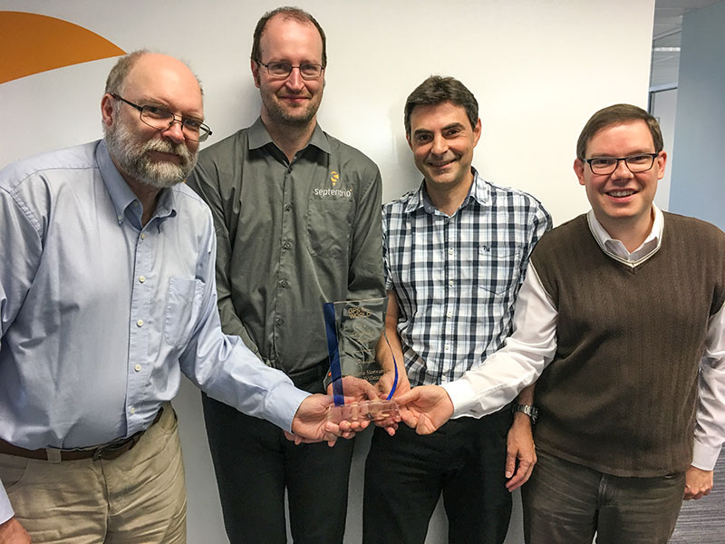
The Septentrio team poses with the Products Leadership Award. (Photo: Septentrio)
The Septentrio team — including Andrew Simsky, navigation algorithms software engineer; Wim De Wilde, system designer; Jean-Marie Sleewaegen, system architect; and Tom Willems, senior researcher — received the 2018 GPS World Products Leadership Award for developing the versatile PolaRx5 receivers, enabling many Earth-observing applications including worldwide ionosphere monitoring. Sleewaegen offers the team’s acceptance speech below.
It is a great honor and privilege to be here and we are very happy to receive this wonderful award. On behalf of my colleagues Tom, Andrew and Wim, and the entire Septentrio team in Belgium, I would like to thank Alan and all sponsors and organizers of this dinner.
From the beginning, Septentrio enjoyed close ties with the scientific community, and we continue to cherish this connection. Our PolaRx receivers, and especially our ionosphere monitoring receiver, is the result of a close collaboration with scientists at universities and research institutes around the world, some of them present here. While the GNSS industry was and is still largely relying on legacy L1 signals, they have been early adopters of all new signals and constellations. For us, this has been a great motivation to implement support for all signals and frequencies at the earliest stage of availability.
Ionosphere scientists are special folks. While most of us dream of getting rid of error sources, they just focus on them, and more specifically on small delays and variations caused by the atmosphere. They don’t want us to filter out these perturbations. On the contrary, they want to see them in their full glory. But the problem is, there are plenty of other error sources. Multipath, clock jitter, vibrations, hardware biases, interference are all out there and are hard to distinguish from what the ionosphere is doing. Our challenge was to minimize those noises and biases to extract the underlying physical signals. This exercise was really instructive, and this technology which we developed for the scientific community is now in the heart of all our receivers.
Looking ahead, while the avalanche of new signals and satellites is an opportunity, it is also a huge challenge. In some regions, we can already track more than 60 GNSS satellites, all transmitting multiple signals, and this number will only keep growing.
How to use all this information? What is the optimal set of signals for a certain application? Are these signals all useful? With the many tracking options, how to guarantee compatibility between vendors? Many open questions still remain to be answered and will keep us busy for the years to come.
We really appreciate the opportunity to be here, thank you for listening!
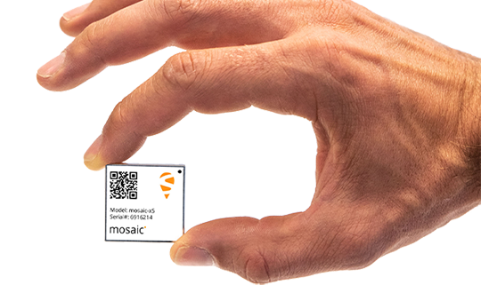
Septentrio has launched the Mosaic high-precision GNSS receiver module.
Despite its compact size (31 x 31 x 4 millimeters, 1.29 x 1.29 x 0.15 inches), the Mosaic module supports more than 30 signals from all six GNSS constellations, L-band and various satellite-based augmentation systems, the company said.
As a multi-band module tracking all GNSS satellites in view, it is also designed to support future GNSS signals.
It also supports correction services, and uses real-time kinematic (RTK) technology, together with Septentrio’s algorithms, to guarantee maximum accuracy and availability. The surface-mount design of Mosaic is optimized for automated assembly and ease of integration, with a full library of well-documented and flexible interfaces.
“Our new Mosaic module represents the best-in-class option for reliable and scalable position accuracy, with integrity,” said Chris Lowet, product manager at Septentrio. According to Lowet, it provides RTK positioning with a power consumption of 0.6-1 W, and requires no or minimal additional components for the design-in. “These characteristics make it an ideal positioning cornerstone for a variety of mass market UAV, autonomous and robotics applications,” Lowet said.
Photo: Septentrio
Robustness to interference. Due to the natural weaknesses of distant GNSS signals and a crowded radio-frequency spectrum, GNSS-based services are vulnerable to unintentional radio-frequency interference (RFI). They are also vulnerable to intentional RFI, attacks intended to disrupt receivers by means of counterfeit GNSS-like signals (known as spoofing), and to intentional transmission of RF energy to mask GNSS signals with noise (known as jamming).
To defend against these threats, Mosaic features Septentrio’s AIM+ technology. AIM+ can suppress the widest variety of interferers, from simple continuous narrowband signals to complex wideband and pulsed jammers, the company added. In addition, the integrated spectrum analyzer allows the RF environment around any Mosaic module to be viewed in real time in both time and frequency domains.
Effective interference countermeasures against threats to GNSS signals also require constant knowledge of the changing RF environment. The Mosaic module helps analyze these threats by continuously and automatically monitoring the GNSS frequency spectrum to detect, characterize, log and mitigate interference events when needed.
Septentrio, Kespry share UAV advances; Game of Thrones, Mission Impossible also highlighted in GPS World webinar.
The UAV inspection industry continues to grow, as evidenced by these case studies of end-user application, presented in a free webinar available to readers of GPS World. As unmanned systems follow precise flight paths to gather data needed for missions in — to cite just a few examples — insurance, mining, construction and the pulp paper industry, they drastically reduce project time, workload and costs.
Narratives of how these tasks and other inspections are performed, and the requirements and challenges for positioning technology they pose, made up the October webinar, “Development Trends and Challenges for UAV Inspection Applications.”
Four expert speakers covered commercial applications in urban and remote areas, including issues generated by obstruction, interference and spoofing. The full webinar audio and slides are available for download.
Septentrio. Gustavo Lopez, product manager for Septentrio, introduced the webinar and covered the main technical challenges and requirements for UAS inspection applications: reliable and accurate relative positioning and orientation; power efficient, vibration-robust technology; fail-safe systems; all-weather flying capability; long-duration precision flying; small data compression; sense and avoid mechanisms; and network centric infrastructure.
Lopez specified the capabilities an onboard GNSS receiver must have: interference monitoring and mitigation, and anti-spoofing — and briefly displayed the company’s products tailored for UAS inspection.
These include: AsteRx-m2, a single-antenna RTK/PPK base and rover; AsteRx-m2a, a dual-antenna RTK chip with 2D orientation; AsteRx-m2(a) UAS, an auto-pilot ready device for easy UAS integration; and AsteRx-i, a GNSS/inertial solution with RTK and 3D orientation.
Multi-Drone Mapping. Todd Humphreys from the University of Texas presented recent research developing the concept of collaborative mapping with multiple drones, creating a 3D display with decimeter accuracy. Ultimately the products from this prototype will serve in autonomous driving applications.
Humphreys displayed the Sensorium, an automobile equipped with stereo cameras, dual-antenna triple-frequency software-defined GNSS, an industrial-grade IMU, automotive radar, LTE connectivity — and a companion deployable UAV for reconnaissance.
Representing “eyes in the sky” for difficult or dangerous intersections. This little fellow carries a dual-antenna GNSS-IMU system developed in-house based on a software receiver delivering centimeter-accurate 2-degree UAV pose estimates.
The webinar then progressed to several Septentrio clients who are out on the leading edge of UAS inspections.
Kespry provides a complete solution for construction and engineering companies to better manage proposed and active earthwork operations. Without using multiple, cumbersome ground control points, survey-grade field data can be collected for an entire site in as little as 30 minutes. (Photo: Nathan Stump/Kespry)
Kespry. UAV manufacturer Kespry provides a complete solution for construction and engineering companies to manage proposed and active earthwork operations. Without using multiple, cumbersome ground-control points, survey-grade field data can be collected for an entire site in as little as 30 minutes.
Attendees learned how drone technology is being used to:
Validate proposed earthwork – reduce rework and extra earthmoving costs before the job begins
Safely measure earthwork activity – ensure subcontractor work and delivered material are constantly measured
Applied to insurance claims for inspections of roof damage, Kespry’s autonomous system improves safety, reduces loss adjustment expenses, and delivers more accurate assessments, while reducing overall costs.
For commercial property, the UAV solution helps prevent losses and informs underwriting decisions with high-resolution aerial and thermal imagery to identify exposures. Mobile tools are provided to review inspection imagery within minutes of flight; artificial intelligence technology generates fully dimensioned wireframes and 3D roof models.
Flying Cam. The webinar links to a YouTube video presentation by Flying-Cam CEO Emanuel Previnaire, showing exciting film footage from popular entertainment. Flying-Cam was closely involved in Game of Thrones, season 7, filming in Los Barruecos Natural Park in Spain; and Mission Impossible 6, filming in the heart of Paris.
The footage, delivered by the company’s UAVs flying very exact, high-speed pre-programmed flightpaths, was used to cinematically recreate flying dragons and exciting helicopter stunt work has been recognized over the years with two Oscars and one Emmy.
The Flying-Cam SARAH E unmanned helicopter, with a payload capability of 10 kg, is open to many sensor integrations. Recent projects have included several high-end sensors: magnetometer, hyperspectral camera system, lidar and more.
Flying-Cam introduced the specific use case of their customer Altametris, in a solution for rail inspection applications. Flying-Cam’s SARAH E successfully performed a lidar aerial survey in a populated area, the train station of Marseille Saint-Charles.
Altametris. A subsidiary of the French National Railway (SNCF), one of the densest and most complex networks in Europe, Altametris participates in monitoring and inspecting a system encompassing 58,000 kilometers of track, 1,700 tunnels, 27,000 bridges and 3,000 stations by using non-intrusive measurement methods (UAVs, robots and more).
Challenges for beyond-visual-line-of-sight (BVLOS) inspections of this vast network include countless obstructions, safety and regulations governing flights over populated areas, and the need to avoid interference with railway operations.
A typical rural scenario of long-range inspection involves a fixed-wing UAV with camera, lidar, multispectral camera and other sensors, flying at 150-meter altitude over a 50- to 100-kilometer stretch. Urban inspection uses rotary-wing UAVs with camera and lidar at even lower altitude (50 meters), along a 5-kilometer corridor.
Employing GNSS/INS solution for positioning and georeferencing combined with lidar leads to precise and valuable data (high-density point cloud, up to 1000 points/square meter). A highly accurate and robust GNSS system is also mandatory for safety and security as it could help to monitor and avoid drone fly-away.
Robust GNSS systems are therefore a key technology for the UAV industry and could open new business opportunities, through safe deployment in inhabited areas, high quality data for metrology,and more.
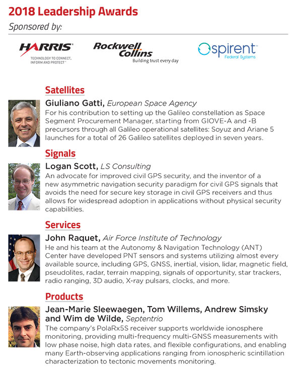
At the GPS World Leadership Dinner and Awards Ceremony in Miami on Sept. 27, 120 VIPs from the international GNSS/PNT community gathered to honor recent significant achievements in four fields: Satellites, Signals, Services and Products.
The honorees, so voted by a panel of their peers, appear below. Also, see our article here.
Their remarks upon receiving the awards will appear in the December issue, along with Future Visions for 2019 by the executive officers of GPS, GLONASS, Galileo and BeiDou.
Rounding out the evening after speeches, dinner and good conversation among good friends, old and new, was the Smart City Jam! We attempted to replicate, on the carpet of the 14th-floor banquet room, an obstructed urban environment, replete with malicious jammers. And we challenged all comers to “autonomously” navigate to a goal in this hostile environment with remote-controlled rock-crawlers. Details on this as well coming up in December.
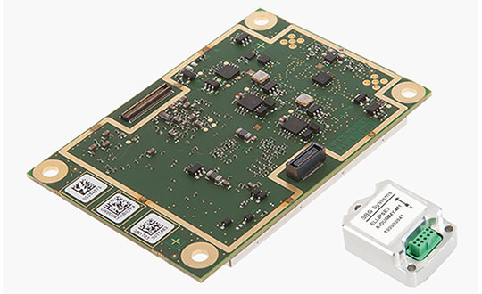
GNSS receiver manufacturer Septentrio has added the AsteRx-i S to its GNSS/INS product portfolio.
The AsteRx-i S combines Septentrio’s compact, multi-frequency multi-constellation GNSS engine with an ultralight external industrial-grade MEMS-based inertial measurement unit (IMU).
Designed around demanding requirements for size, weight, power consumption and temperature variation, the AsteRx-i S is designed for various applications such as inspections with UAVs, UAS photogrammetry, automation, robotics and logistics.
Calibrated for wide temperature ranges, the AsteRx-i S delivers accurate and reliable GNSS/IMU integrated positioning to the centimeter-level, as well as full attitude at high update rates and low latency, the company said.
Key benefits for users include:
GNSS/INS positioning with 3D attitude: heading pitch and roll
AIM+ interference monitoring and mitigation system
High-update rate, low-latency positioning and attitude
Small and ultralight IMU (10 grams)
Robust calibration for wide temperature ranges
“We are delighted to broaden our AsteRx-i GNSS/INS solutions range, bringing maximum flexibility and choice to our customers,” said Francesca Clemente, product manager at Septentrio. “Whether for direct georeferencing in mapping applications with UAVs, for managing containers in a port or for innovative small robots in agriculture, the compactness, affordability and robustness of the AsteRx-i range allows our customers to focus on their success.”
An upcoming episode of “Advancements” with Ted Danson will explore recent developments in autonomous vehicles such as drones, cars, trucks, excavators and other heavy machinery.
The episode is scheduled to broadcast in the fourth quarter of this year.
Image: Advancements
The segment will focus on Septentrio’s secure GNSS technology for unmanned systems. Septentrio is a designer and manufacturer of GNSS receivers and surveying equipment, delivering accurate and precise GNSS positioning scalable to centimeter-level even in challenging environments.
Advancements will educate viewers about Septentrio’s GNSS technology, which provides both the accuracy and robustness required, while integrating and synchronizing seamlessly with navigation systems and payloads.
“In a few years, autonomous cars will be driving us around, with greater safety, efficiency and comfort than ever before,” said Jan Van Hees, director of marketing and business development, Septentrio. “All of these vehicles depend critically on a multitude of sensors to determine where they are, with robust GNSS sensors at the heart of the system. It is critically important that the GNSS technology used supplies not just highly accurate data, but also a high level of reliability. That’s where the technology from Septentrio comes in.”
Autonomous trucks and agricultural machines are already being used to make worker activities safer and more efficient. Drones can go to places that would otherwise be too expensive or dangerous for human workers to reach.
Farmers use unmanned systems to survey and even spray crops; NGOs employ them to launch search and rescue operations in disaster zones; event coordinators monitor crowds with them at major musical festivals, and conservationists can track and protect endangered species better in risky areas with them.
“For many years now, driven by our customers, we have been developing GNSS technology for industrial applications that is not only very accurate, but also reliable in the harshest of environments,” Van Hees said. “With the advent of drones and the interest in developing autonomous cars and trucks, this focus on secure GNSS is becoming ever more important. It’s exciting to see this technology affecting our daily lives more and more.”
“UAVs and other autonomous systems have an enormous potential in aerial surveying, inspection, and a host of other industries,” said Rochelle Hyman, senior producer for the Advancements series. “The autonomous industry is important to Septentrio, and we look forward to sharing the innovative technologies that have been designed and developed by the company.”
The Advancements series is an information-based educational show, targeting recent advances across a number of industries and economies. Featuring state-of-the-art solutions and important issues facing today’s consumers and business professionals, Advancements focuses on cutting-edge developments, and brings this information to the public with the vision to enlighten about how technology and innovation continue to transform our world.
As the dust from this year’s AUVSI Xponential show, which took place May 1-4 in Denver, begins to settle, we complete the overview we began last month and wrap up our coverage of the show.
Septentrio
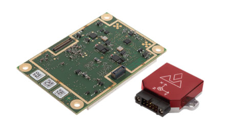
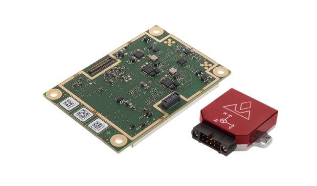
Septentrio introduced its AsteRx-i V product series of integrated GNSS/inertial receivers, based on the Septentrio m2 GPS/GLONASS/Galileo/BeiDou/QZSS/SBAS receiver and a high-end VectorNav MEMS IMU. Providing:
AsteRx-i V receiver & IMU. (Photo: Septentrio)
Reliable, accurate IMU-enhanced GNSS positioning down to the cm level
Full attitude — heading pitch and roll
Lightweight, low power <50 grams, typically 1.5 W — suitable for UAV applications
AIM+ interference monitoring and mitigation system
High update rate, low-latency positioning and attitude
Also introduced at the show was the AsteRx SB, a packaged version of the m2 receiver with multiple interfaces and Bluetooth wireless, targeted at machine control and other sensor fusion applications.
GSS9000 Simulator. (Image: Spirent)
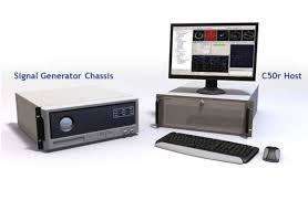
Spirent Federal
Spirent offered a demo of its “flagship” GSS9000 simulator at the show — with capability to generate all constellations, all frequencies, plus L-band signals. Kalani Needham (director of sales) also mentioned the company’s sim-MNSA program with Rockwell Collins, aimed at providing support for M-code for the GNSS simulation market.
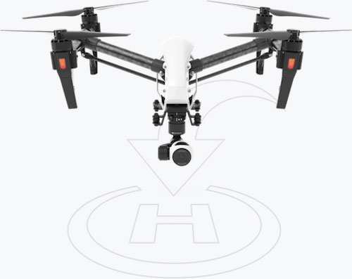
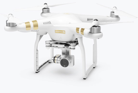
DJI
Inspire drone. (Image: DJI)
As usual, the DJI booth was extremely busy — with a demo area almost continuously flying each of the most popular DJI drones. What I learnt from my visit was that 70 percent of sales are recreational, and the balance is commercial. With quadcopters for hobbyists, using replaceable parts, auto-flight systems and data links, DJI was virtually the first drone manufacturer to market, and still one of the most successful. The Phantom now carries gimbal-mounted cameras and is finding lots of applications with business, academics and government agencies, including first adopters like the film and TV industry.
Phantom 3 drone. (Image: DJI)
DJI drones have weather resistant bodies, strong blades, swap-out easy-charge batteries, and ADS-B, RTK and heading capabilities. Set-up in the field is simple, with an SDK for lab developers, multi-spectral cameras for applications such as crop growth monitoring, real-time data available through the control uplink and infrared/visible slant-range outputs.
DJI’s approach is to keep ahead of the competition by adding more and more technology over time, and the company clearly has the sales volume to support this strategy.
CyPhy Works
PARC tethered drone system. (Photo: Tony Murfin)
CyPhy Works makes and promotes tethered drones — enabling very long endurance reconnaissance/forward observation/inspection/communications. The company got into this specific drone niche because it found customers who couldn’t live with short duration battery-restricted drone operations.
For ground forces, having a real-time video overview from higher altitude is of great benefit; similarly, they’re of great use for disaster recovery efforts, such as in the aftermath of hurricane Harvey in Texas. And if you add a Wi-Fi transducer working through one of two payload ports on its PARC (persistent aerial reconnaissance and communications) platform, you can also reconnect survivors and provide a comms network for first responders.
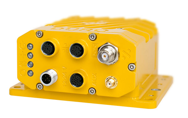
Ruggedized Duro receiver. (Image: Swift Navigation)
Swift Navigation
Swift is a relatively new GNSS receiver manufacturer, and its Piksi Multi receiver has a lot to do to catch up technically with the products offered by the predominant players in the market. So its approach is to use rock-bottom pricing for almost all of their offerings. Currently, the Piksi has only GPS L1/L2 and GLONASS L1/L2 plus SBAS, but Galileo and BeiDou are promised for later this year.
The new Swift capability launched at the show is Skylark, a cloud-based, hybrid PPP/RTK network currently testing in around six U.S. areas and planned for national and even worldwide coverage sometime in the future. Skylark is apparently cellular, with a large number of base sites, each equipped with a Swift Duro receiver. With a target subscription price of only $495 per year, this could be a popular GNSS assistance service, provided you use compatible Swift receivers in your application.
Swift is targeting automotive applications, and has a San Jose trial underway with Voyage at a retirement community — residents call for a self-driving taxi using a cell-phone app, and get transport anywhere in the 4,000-strong community. A similar trial at the Villages in Florida (125,000 residents and 750 miles of roads) is also apparently getting underway.
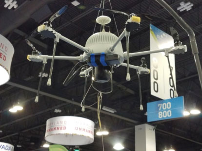
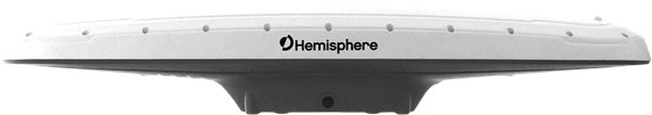
Hemisphere GNSS was also at the show with its line of GNSS receiver solutions for UAVs, Atlas Correction Service and a new V500 Heading/Smart Antenna.
The Vector V500 is an all-in-one multi- frequency, multi-GNSS smart antenna that provides RTK-level position and precise heading. The latest generation of Hemisphere’s heading antennas now appears with an integrated GNSS receiver and a rugged design sealed for the harshest environments — a design that has evolved over many years. It takes a great deal of sweat and tears to get to a reliable weather-hardened product, and Hemisphere has no doubt incorporated a lot of experience into this latest product.
Atlas corrections are derived from public JPL data and are supplied worldwide over Inmarsat L-band satellite transmissions.
Harxon Corporation
D-Helix antenna. (Photo: Harxon)
Harxon’s D-Helix antenna got lots of attention at its booth, as did the OEM frequency-hopping transceiver. The D-Helix antenna supports GPS, Galileo, BeiDou and GLONASS, as well as L-band signal reception. With low wind resistance and ruggedized IP67 protection, this antenna appeared to be very popular at the show for UAV applications.
The frequency-hopping OEM transceiver works over 840-900 MHz and weighs in at only 5 grams. With anti-jamming and wide signal capability, this miniature device is designed for complex data-intensive applications. In full duplex mode, secure data transmissions are possible over long distances with low latency. The popularity for this transceiver at the show might be connected with a recent FAA proposed rule that would require transmission of a drone’s registration ID for remote identification.
More
Other neat products and applications the GPS World team came across at the show included:
Topcon’s B111 multi-constellation GNSS receiver and the Topcon-distributed Sirius Pro fixed-wing UAV and Intel Falcon 8+ quadcopter;
the Rockwell Collins aviation Flight Management System, which is apparently being incorporated into the General Atomics commercial Flight Guardian system;
the senseFly eBee series of drones with automated mapping capability and a BVLOS (beyond visual line of sight) trial in Canada with in-flight data — more on this later.
GPS World will bring you a special UAV supplement later in the year, and we will carry more news and details on selected manufacturers and applications within this exciting and ever-expanding drone industry.
Septentrio’s Jan Van Hees discusses the company’s AsteRx-i V IMU-enhanced GNSS receiver at Xponential 2018. According to the company, AsteRx-i V features its AIM+ interference mitigation and monitoring system, which can suppress a wide variety of interferers.
A roundup of recent products in the GNSS and inertial positioning industry from the May 2018 issue of GPS World magazine.
SURVEY & MAPPING
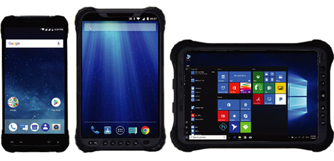
Rugged handhelds
Operate in harsh environments
The UT series of GNSS-capable rugged handheld devices support industries such as construction, survey, GIS, mapping, asset/logistics management, public safety, utilities and military. The UT10 6-inch rugged phone and UT30 8-inch rugged tablet both feature Android 8.0 operating systems with Qualcomm octa-core 2.2 GHz processors, 4 GB of RAM and 32GB onboard storage.The UT50 10.1-inch full-rugged tablet features the Windows 10 operating system with an Intel Core Skylake i5 processor up to 2.8 GHz, 8 GB RAM and 128 GB of onboard storage. All three new UT models provide the latest high-resolution, capacitive touchscreen and direct sunlight-readable display technology for ease of visibility in all situations. The UT50 also has a 10-finger multi-touchscreen and supports wet hands and gloves operation. The devices have dual built-in cameras. They are designed to be drop-resistant from heights of 1.2 meters (1.5 meters for the UT10), are rated at IP67 (IP68 for UT50), and are certified to both MIL-STD-810G and MIL-STD-461F military standards to ensure durability in most outdoor or challenging environments.
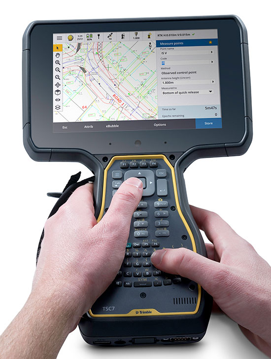
The Trimble TSC7 controller is a new field solution for land and civil construction surveyors. Equipped with GPS, it provides a tablet experience with a physical keyboard and a sunlight-readable 7-inch touchscreen that supports pinch, tap and slide gestures. Front- and rear-facing cameras allow users to video conference their office from the field for on-the-job support, and capture high-definition videos and images that provide valuable context to their data and clients. The TSC7 uses Windows 10 Professional with an Intel Pentium 64-bit quad-core processor. The processor and operating system make it easy to process data in spreadsheets and run office software programs. An ergonomic form factor, IP68-certified rugged design and optional, user-interchangeable modules make the TSC7 a flexible solution for all surveying applications.
The AsteRx-i combines a multi-frequency multi-constellation GNSS engine with an external industrial-grade MEMS-based inertial measurement unit (IMU) to deliver positioning to the centimeter level as well as full 3D attitude at high update rates and low latency. The AsteRx-i is suitable for optical inspection and photogrammetry. Accompanied by a UAS-tailored carrier board, it integrates seamlessly into light UAVs. It also features Septentrio’s AIM+ interference monitoring and mitigation system.
UAS startup DropCopter has initiated a drone pollination service that uses multi-rotor drones to dust almonds, pistachios and cherries, boosting crops by up to 15 percent. Dropcopter’s patent-pending Worker-Bee pollinator helps growers overcome environmental factors like bee shortages, as well as wind, cold, and night time that would prevent honeybee activity. The company is partnered with GENIUS NY and The NUAIR Alliance.
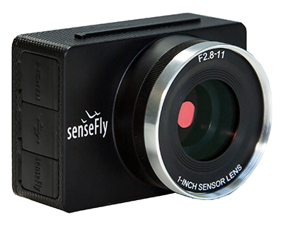
Sensor Optimized for Drone Applications (S.O.D.A.)
Photo: senseFly
The senseFly S.O.D.A. camera is built for professional drone photogrammetry work. It captures sharp aerial images across a range of light conditions, allowing users to produce detailed, vivid orthomosaics and ultra-accurate 3D digital surface models. It has a 1-inch 20 megapixel RGB sensor that provides ground resolution of 2.9 centimeters per pixel flying at 400 feet (122 meters) above ground level. It has built-in dust and shock protection, enabling mapping across challenging terrain.
Septentrio’s Gustavo Lopez offers a rundown on the company’s AsteRx SB ruggedized multi-frequency GNSS receiver at Xponential 2018 in Denver. According to the company, the AsteRx SB can operate in RTK rover or base station mode and, with an on-board 16GB memory, it can log data for offline post-processed PPK.
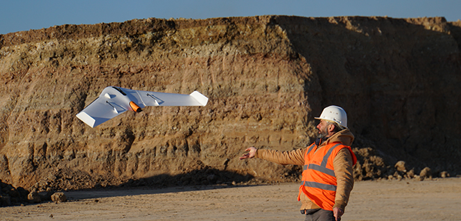
The UX11 is a lightweight, beyond-visual-line-of-sight (BVLOS)-ready fixed-wing mapping drone.
The combination of on-board processing capabilities, real-time control and centimeter-level precision make it a cost-effective solution for large area surveying and mapping, Delair said.
The Delair Septentrio UX11 mapping UAV. (Image: Septentrio)
By employing the latest high-specification photographic, sensor and communications elements, Delair has kept the weight of the UX11 — including payload — down to 1.4 kilograms (3.1 pounds). Among other design innovations, this allows the UX11 to cover 200 hectares (500 acres) in a single one-hour flight, delivering mapping with ground sample distances below 1 centimeter per pixel (0.4 in/px) with accuracy down to 1.27 cm (0.5 in).
A 3G/4G network link to the UX11 allows the operator to assess in real time the quality and overlap of images during flight and make any necessary adjustments to the settings of the integrated camera. This enables operators to collect as much aerial intelligence as possible in a minimum number of flights.
The UAV also features BTOL (bird-like take-off and landing) for steep-climb take offs and descents in confined areas.
The AsteRx-m2 delivers high-precision multi-frequency quad-constellation GNSS measurements for PPK (post-processed kinematic) for only 28 grams, and consumes very little power.
The combination of high-quality camera images and GNSS measurements from the AsteRx-m2 allows Delair to offer its users PPK survey-grade ground precision down to 1 centimeter. With Delair’s PPK software, powered by Septentrio’s GeoTagZ PPK library, users only pay for the precision they need and on a flexible pay-as-you-go basis.
“With the AsteRx-m2, we can offer wide-area coverage at ultra-high precision,” said Chase Fly, geospatial product manager at Delair. “The Delair UX11 sets a new standard of efficiency, cost and quality in a long-range UAV platform. The drone itself is truly state-of-the-art in its design and construction, and it enables industry-leading performance and flight range, as well as streamlined maintenance, advantages that all reduce costs.
“The integrated processing capabilities are able to ensure image quality in real time and provide users with accurate results that shape critical operational decisions and strategies,” Fly said. “And it’s designed for flexible use in a variety of conditions and use models, further lowering TCO.”
The AsteRx-m2 features Septentrio’s proprietary GNSS+ suite of positioning algorithms to convert difficult environments into good positioning:
LOCK+ technology to maintain tracking during the heavy dynamic vibration typical of UAV flights
APME+ to combat multipath
IONO+ technology to ensure position accuracy during periods of elevated ionospheric activity.
The AsteRx-m2 also features AIM+ interference mitigation and monitoring system that can suppress the widest variety of interferers, from simple continuous narrowband signals to the most complex wideband and pulsed jammers.
AIM+ can diagnose self-interference from other electrical or electronic devices onboard the UAV as well as mitigating external interference during operational flights.
“Driven by the explosion in the number and variety of drone applications, drone technology has advanced leaps and bounds in recent years and Delair have been right at the heart of the action. With their focus on innovation and a commitment to providing the very highest quality products, Delair and Septentrio are true kindred spirits and we’re proud to be part of the UX11 project,” said Gustavo Lopez, product manager at Septentrio.
The AsteRx-i combines Septentrio’s latest compact, multi-frequency multi-constellation GNSS engine with an external industrial-grade MEMS-based inertial measurement unit (IMU). It can deliver accurate and reliable GNSS/IMU integrated positioning to the centimeter level as well as full 3D attitude at high update rates and low latency.
Key benefits for users:
IMU-enhanced GNSS positioning with full attitude: heading pitch and roll
AIM+ interference monitoring and mitigation system
High-update rate, low-latency positioning and attitude
Designed around demanding requirements for size, weight and power consumption, the AsteRx-i is suitable for optical inspection and photogrammetry.
Accompanied by a UAS-tailored carrier board, the AsteRx-i integrates seamlessly into light UAVs. The versatility of design and range of connection interfaces extend the AsteRx-i applicability to automation and robotics and as well as logistics.
The AsteRx-i includes Septentrio’s GNSS+ suite of positioning algorithms to convert difficult environments into good positioning: LOCK+ technology to maintain tracking during heavy vibration, APME+ to combat multipath and IONO+ technology to ensure continued position accuracy during periods of elevated ionospheric activity.
It also features AIM+ interference mitigation and monitoring system which can suppress the widest variety of interferers, from simple continuous narrowband signals to the most complex wideband and pulsed jammers.
“Complementing our GNSS portfolio with an INS offering is a natural evolution of our product range. At Septentrio, we design our GNSS solutions with a focus on reliability and availability. Smart integration of inertial sensors builds on these strengths to make affordable high-precision positioning and orientation solutions possible for ever more demanding applications,” said Francesca Clemente, product manager at Septentrio.