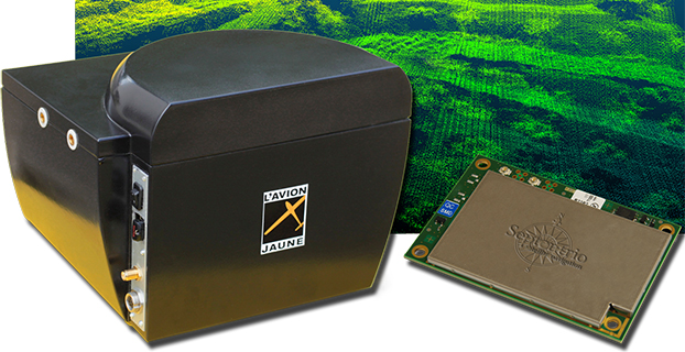
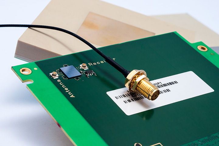
L’Avion Jaune, a service provider and airborne sensors integrator in the field of aerial surveys, has selected the Septentrio AsteRx-m to equip its YellowScan unmanned aerial system. L’Avion Jaune chose the AsteRx-m for its robustness and low-power consumption, Septentrio said.
YellowScan is the a lightweight all-in-one solution designed to deliver quality aerial surveys carried out using a LiDAR sensor aboard UAVs. The self-contained system integrates into a small package all the necessary equipment for conducting airborne surveys: a 3D laser scanner, an AHRS, a controller, an autonomous power supply module and the AsteRx-m, a high-performance precision GNSS receiver.
The AsteRx-m provides a compact and low-power solution for precise positioning in difficult environments where the tracking of both GLONASS and GPS satellites allows the receiver to improve the availability and robustness of a positioning solution. Septentrio’s newest RTK models optimally adapt to situations where GNSS signals can be distorted by reflective surfaces and feature unique countermeasures to disturbances, maintaining accurate and stable measurements wherever and whenever centimeter-level accuracy is needed, the company said.
“The easy-to-integrate AsteRx-m has proven to deliver the most reliable and stable RTK performance of all, in a compact and exceptionally low-power consumption module,” said Michel Assenbaum, CEO of L’Avion Jaune. “The AsteRx-m allows us to extend the operational range and capabilities of the YellowScan, a fully autonomous surveying solution dedicated to UAVs. We have tested the solution in various environments across the world and have never seen it falter.”
“We are delighted that L’Avion Jaune, a respected expert in designing unmanned-aerial remote sensing solutions, has validated the excellent performance of our ultra-compact GNSS receiver,” said Jan Van Hees, head of business development at Septentrio. “We are impressed to see how much interest YellowScan has drawn since its introduction and we are very proud to be contributing to the success of a best of breed solution in this highly competitive market.”
Altus Positioning Systems, a Septentrio company, has integrated its APS-GeoPod product with Entegra Technologies’ Crossfire Pro Tablet. This collaboration, targeting the oil and gas, survey, GIS and transportation industries, provides a high-performance tablet-based solution for enabling ultra-precision RTK of sub-meter or centimeter accuracy.
Altus is showcasing the APS-GeoPod and Crossfire Pro tablet, along with the full range of Altus products, at booth A1.060 and outside Booth FG.006 at InterGeo 2014 being held this week in Berlin, Germany.
According to Altus CEO Neil Vancans, the Altus APS-GeoPod and the Entegra Crossfire Pro Tablet provide a combination of precision, performance and features that make it ideal for energy services, land surveys and other GIS-related applications.
APS-GeoPod is a compact GPS/GLONASS RTK and DGNSS receiver that adds high-precision RTK positioning to USB-compatible tablet PCs. “This unique product gives users the convenience of adding RTK precision to any on-board application on mobile devices geared to the field service professional,” Vancans said.
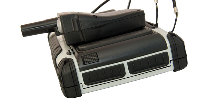
The Entegra Crossfire Pro tablet. Photo: Altus Positioning Systems
APS-GeoPod features include:
Compact dual-frequency GNSS module
Low power consumption (<1 Watt)
USB 2.0 interface
Internal L1 GPS/GLONASS antenna
NMEA integration with GIS software
The Crossfire Pro tablet features the multi-touch interface and communication capabilities of smartphones, the large display and ergonomics of consumer tablets, and the daylight-readable screen and durability of rugged tablets. Safety features include UL 1604 Class I/Division II certification for operation in hazardous locations. To users, Crossfire Prodelivers a customizable tablet for exacting daily activities, resulting in greater efficiencies, response times, productivity and customer service levels, the companies said.
The announcement is notable in that it expands the relationship formed in June 2011 between Septentrio and Altus, with Septentrio more closely integrating the Altus subsidiary. Additionally, Septentrio is now manufacturing Altus GNSS RTK receivers at its factory in Belgium while Septentrio is closing its separate sales office in the U.S., merging that functionality into Altus, according a spokesman.
The Torrance, California-based Altus, started by Vancans in 2007, has long focused on the surveying sector. Vancans himself is a Fellow of the Royal Institution of Chartered Surveyors in the U.K.
“Ten years ago 90% of the high-precision GPS market was survey or survey-related. But survey is not a high-growth market. Today survey is probably 20% of the market and that’s doing things like putting a $10,000 receiver on a $4,000 lawn mower,” Vancans explains. “The growth market outside that (in consumer wireless) is huge, and it offers many new opportunities and will continue to grow.”
The survey market will continue to be in the Altus and Septentrio strategy, particularly leveraging Altus products with Septentrio’s advanced receiver technology experience in the OEM market.
Vancans has watched for two decades as use in emerging Asian economies has increased demand for surveying equipment and speculates what’s happening in the U.S. and other Western markets with OEM growth will eventually be mirrored there. He estimates the Chinese receiver market alone has grown ten-fold since he worked as president of Leica GPS nearly 20 years ago.
“What’s interesting and exciting is that it will be a big growth market for OEM or non-survey applications based on domestic Asian manufacturers using Western and increasingly Asian OEM,” Vancans says.
“If you can master the distribution capabilities in the OEM market in North America in the next couple of years, that will form the foundation of what happens in Asia in the future.”
Altus’ announcement also came with news the company hired Mo Kapila as OEM sales manager for Septentrio products. Kapila’s background is in embedded wireless, according to Vancans.
Vancans, who spent two days on the CTIA show floor, says the consumer wireless industry is on Altus’ radar, although he is still “very wary” of that side of the business. As general manager of Thales Navigation (which later re-merged as Magellan) in the early-2000s the company worked on a GPS attachment for Palm and integration into other consumer devices.
“The professional high-precision market is stable and products have a long shelf life,” he says. “On the other hand, the good thing with the consumer market is the constant changes in devices, the churning. As consumer markets take up high-precision GNSS products , they will be embedded in products which are rapidly outdated.”
Altus is taking a wait-and-see approach when it comes to professional-grade receivers for the consumer market.
“If the price lowers, the longevity will too,” he says. “The high end will likely go down to meet the low end – the cheap and easy, changeable model.”
Vancans says Septentrio will continue to differentiate itself from competitors based on its low power consumption relative to the functionality and size of the device, and robust positioning, whether it’s for professionals or consumers.
“If you look to the future and think of how much satellites will proliferate and signal availability will open,” he says, “it’s a good position for us to be in with the continuous consumerization of high-precision GPS and GNSS.”
Septentrio — a manufacturer of high-end GNSS receivers for demanding professional navigation, positioning and timing applications — is consolidating its sales, service and customer support functions for the Americas in Altus’ facility located in Torrance, California.
“This decision to base Septentrio’s sales and support functions for the Americas with Altus marks the next logical step in our evolving business relationship and professional collaboration with our parent company Septentrio,” said Neil Vancans, president of Altus. “We look forward to leveraging the strengths of both our organizations to grow the market for Altus and Septentrio products across a wide range of market sectors.”
Altus has added industry veteran Mo Kapila as OEM sales manager for Septentrio products. Kapila is based in Altus’ office in Torrance, California. Before joining Altus, he was vice president of sales for Qualinetics, a pioneer in vehicle telematics.
Kapila previously held senior sales management and business development roles at B&B Electronics and Quatech, as well as OEM product management positions at DENSO and Clarion Corporation. He is a graduate from the University of Michigan with a B.S. degree in mechanical engineering.
From a weather perspective, Aberdeen, Scotland, may not be the most inviting location in the world in which to live. Nevertheless, Aberdeen is the leading European oil & gas business hub and is one of eight “super cities” spearheading the UK’s economy. But it’s waaaaay up north of the border with England on the east coast of Scotland — winter conditions can be difficult, even inhospitable at times. But if you want to transmit differential corrections out to shipping and oil rigs in the North Sea, it’s an ideal location.
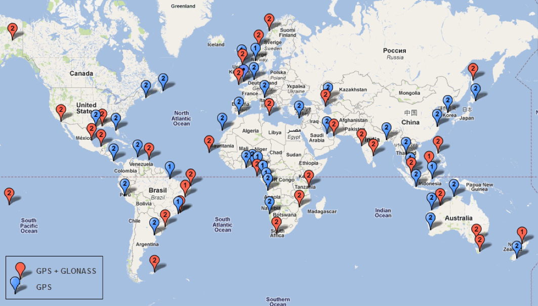
Since its first beginnings in Aberdeen, Veripos has evolved to become a major worldwide business for marine, and now also for “precise land navigation, positioning and guidance solutions.” Veripos is now delivering augmentation services on a global basis, employs more than 130 specialist personnel based in 11 sites around the world, and in 2013 had revenues of more than $45 million. With a global ground network of more than 80 dual-redundant receiver base stations, Veripos now provides not only traditional differential GNSS transmissions, but also precise GPS and GLONASS orbit and clock corrections over seven Inmarsat GEOs and also via the Internet — we now call Precise Point Positioning (PPP).
Veripos ground receiver station network.
Veripos began in March 1989 as a joint venture between Brown & Root Survey and Ormston Technology, a specialist marine electronics company based in Hull, England. Initially, Veripos provided a conventional Differential Global Positioning Service (DGPS) for users in the North Sea based on HF radio transmitters.
Introducing a much broader satellite-based DGPS service in 1994, coverage was extended to cover the Gulf of Mexico followed by further expansion of the network/coverage into Brazil, West Africa, Mediterranean and Caspian Sea. Veripos became a wholly-owned subsidiary of Subsea 7 in the same period. Following a major expansion in late 2004, full global service coverage was achieved in 2005, and ultimately Veripos became the second largest precise satellite positioning services supplier in the world to the marine industry, with leading clients in exploration, seismic, construction, survey, offshore supply vessels (OSV) and offshore drilling. In late October 2012, Veripos diversified further, launching its TerraStar business to address the land and near-shore sector.
Achieving global accuracies of 5-10 centimeters using relatively small amounts of data, users worldwide are mostly able to accommodate the initial convergence time needed to achieve these higher accuracies. Veripos claims that using multiple constellations, convergence time can be down to less than 10 minutes — even lower for hot starts.
The “free” IGS data that competes with Veripos and other subscription correction providers is also pretty good, but it’s not generally used by commercial operations.
IGS Multi-GNSS Experiment Tracking Network.
IGS data is provided by academic and government sources around the world, and the advantage is not only free access, but also open data and multiple open-source software tools and data, all built to published open standards. But the IGS system is not a 24/7 reliable data source, and support can be a problem. It’s not designed for companies who must have service guarantees in order for them to consistently operate profitably in difficult conditions — it’s more experimental, for research and testing for the academic and government outfits that produce the data, along with a whole bunch of engineering teams who take advantage of free data and can cope with system hiccups for their R&D and for comparison purposes.
So Veripos and other commercial providers overcome the weaknesses of IGS by providing a worldwide network that is well maintained — an infrastructure designed for high reliability and availability. Each base station has dual-redundant receiver and communications links. There are three processing centers, two active and one on warm standby, that can each operate the whole system, and each of the processing centers has dual-redundant equipment. There are seven geostationary satellites with a large degree of coverage overlap, and Internet data feeds also provide a backup. More than these system design features, Veripos works directly with its customers to ensure successful integration of their corrections with customer operations and, above all, supports the customer directly during these operations. If the customer is not operational, Veripos recognizes that down time means lost profits for its customers, so its staff work hard to avoid any service interruptions.
It’s not clear what would happen to this currently stable marketplace if and when Galileo begins selling a commercial service on E6, but the existing commercial service providers are pretty sure that competition in their segment from a government provider that is publicly funded is not in their best interests. At the recent Munich Satellite Navigation Summit, Gian-Gherardo Calini from the European GNSS Agency certainly received a clear message from Trimble, NovAtel, Veripos and Fugro (to a lesser extent) that these companies do not believe that Galileo should be entering their market. However, Calini did state several times that the GNSS agency did not want to disrupt this market. How to do that when the Galileo infrastructure, control systems and satellites are wholly government funded remains unclear. Even if the service were wholesaled to a commercial provider, it’s unlikely that the retailer would have to bear the full cost of maintenance and support of the entire Galileo ground and space infrastructure, so their service would in effect be hugely subsidized.
Veripos recognized that focusing on its marine service alone is ignoring the land segment. So the company established a new business called TerraStar to address the land segment, just as Fugro had spun off OminSTAR for the land segment many years ago. TerraStar is still a division of Veripos, and the PPP infrastructure and distribution system it uses is the same. TerraStar is focused entirely on land and close-to-shore operations, so its business development and marketing is aimed at wholesaling its services through OEMs for these segments, while Veripos continues in parallel solely with marine and offshore.
Initial OEMs to sign up were Septentrio and Altus, which is a subsidiary of Septentrio that focuses on survey products and applications. Septentrio had a number of successes with DEME dredging and land reclamation in Belgium and terrascan airborne geophysical survey in South Africa and Germany.
Terrascan airborne geophysical survey.DEME land reclamation.
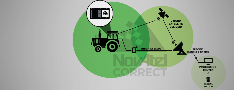
And here we arrive at the place where these companies all start to come together. In mid-March this year, Hexagon acquired Veripos, along with TerraStar. Hexagon is, of course, the parent that has NovAtel and Leica in its thoroughbred stable of GNSS industry leaders. Could this acquisition have something to do with John Deere/NavCom operating its own StarFire PPP system, or Trimble acquiring OmniSTAR from Fugro and now providing its own range of PPP correction services?
Well, NovAtel rolled out NovAtel Correct and new software at the end of March for its OEM6 high-precision receivers, which includes TerraStar’s precise point positioning (PPP) corrections. And NovAtel now has a closely associated company within the Hexagon stable, so a long-term association between NovAtel and Veripos/TerraStar is just about assured. And, with a big company group like Hexagon and many potential connections between group members with common interests, the prospect for continued investment as revenues increase means Veripos should be even better positioned going forward.
And, of course, adding NovAtel customers, including other potential OEM third parties, to the Veripos/TerraStar user base all helps both companies’ revenue and keeps their parent Hexagon happy too. So actually, it’s all about increasing the bottom line!
The PolaRxS by Septentrio is a multi-frequency, multi-constellation receiver dedicated to ionospheric monitoring and space weather applications. It features simultaneous high-quality tracking of all visible signals (L1, L2, L5, E5ab/AltBOC GPS/GLONASS/Galileo/Beidou/SBAS) at low noise levels. The receiver outputs an extensive set of GNSS measurements, including signal phase and intensity at up to 100 Hz, with a phase noise standard deviation (phi60) as low as 0.03 rad.
The A Posteriori Multipath Estimator (APME+) tackles short-delay multipath to enhance the measurement quality, while LOCK+ tracking guarantees robust tracking of rapid signal dynamics during scintillation events. Included tools provide continuous total electron content (TEC) and scintillation indices logging for space weather and ionosphere monitoring.
Learn about more Galileo-ready products in our Galileo Product Showcase from the April 2014 issue.
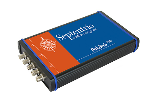
Veripos, a global provider of precise satellite positioning solutions to the international offshore and marine industries, is concluding the upgrade of its global network of GNSS reference stations with high-performance multi‑frequency GPS/GLONASS/Galileo/BeiDou receivers from Septentrio.
Veripos owns and operates a network of more than 80 reference stations worldwide that is used to determine estimates of the orbit and clock errors of multiple GNSS satellite constellations. Veripos uses these estimates to calculate corrections which are then broadcast to end users to significantly improve the accuracy of positioning. At the heart of the network is Septentrio PolaRx4, a full-featured reference receiver that provides high-quality tracking and measurement of all available and upcoming GNSS signals.
The upgrade of the Veripos global network of reference stations with the latest Septentrio reference receiver technology is an outcome of the multi-year collaboration between the two companies. Septentrio also supplies Veripos with multi-frequency GNSS and heading receivers for its marine business, including the LD series of integrated mobile units that deliver the complete range of Veripos augmentation services to its customers worldwide.
“Septentrio reference stations are renowned for their excellent data-quality and robustness,” commented Bobby Johnson, Chief Technical Officer of Veripos. “Septentrio technology enables us to provide a full range of services and to remotely manage and upgrade the hardware to enhanced features, which is crucial for managing a worldwide reference network, where the equipment is often not easily accessible.”
“We are delighted to see continued positive outcome from the technical and commercial relationship we have established with Veripos over the years and that has developed into Septentrio enabling Veripos to deliver a variety of solutions with high-quality and robust industrial performance everywhere on the globe to the benefit of a multitude of users in one of the most demanding industries,” said Jan Van Hees, head of sales and business development at Septentrio.
Imec and Septentrio have collaborated to design multi-frequency GNSS antenna that simultaneously receives all GPS, GLONASS, BeiDou, and Galileo bands. Developed under the European Community’s Seventh Framework Programme project Handheld, the compact antenna can be integrated in multi-frequency handheld GNSS devices for high-precision location applications up to 1 centimeter.
The announcement came at the Mobile World Congress being held this week in Barcelona, Spain.
The compact antenna integrates Imec’s GNSS antenna and Septentrio’s GNSS RF front-end. Imec’s antenna design satisfies the requirements for the high-accuracy GNSS market while remaining small enough to fit in a handheld surveyor device, the companies said. The antenna has desired uniform gain and phase coverage over the complete upper hemisphere, with strong suppression of unwanted reflected signals below or in the vicinity of the GNSS receiver.
The GNSS RF front-end, based on established front-end technology developed by Septentrio, is characterized by a superb out-of-band interference rejection to avoid notably device self-interference with other radiation sources such as Bluetooth and WLAN radios, as well as other ambient intentional and non-intentional interference. The compact multi-frequency antenna is a perfect companion of Septentrio’s compact and low-power AsteRx-m receiver, a credit card-sized dual frequency GNSS receiver that provides centimeter accuracy at less than 500-mW power consumption, by far the lowest power consumption in the professional GNSS market.
The research leading to these results has received funding from the European Union Framework Programme (FP7/2007-2013) under grant agreement n°287183.
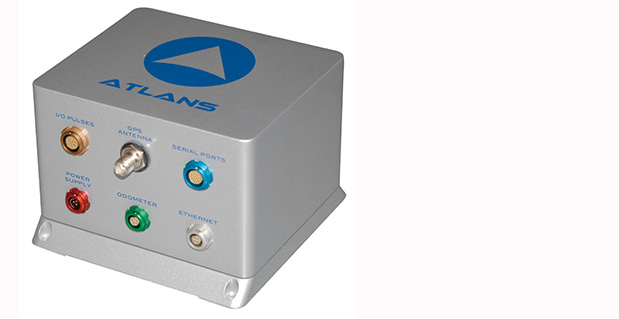
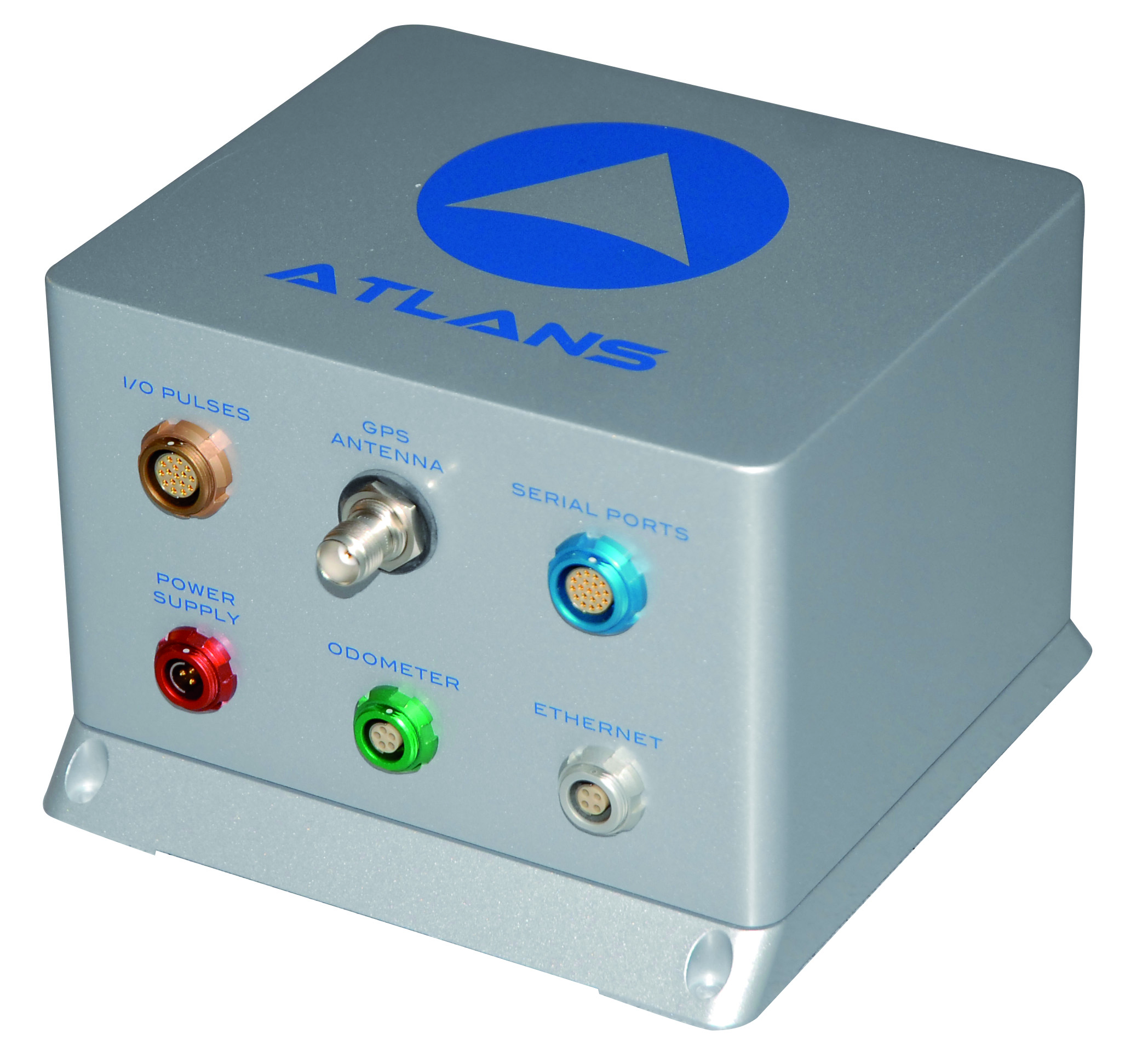
iXBlue, a provider of navigation, positioning, and mapping solutions, has launched its new ATLANS-C position and orientation system, developed in close cooperation with Septentrio Satellite Navigation. The system is designed to provide continuous and accurate positioning in urban environments, where GNSS signals are obscured, intermittent, or possibly distorted by reflective surfaces.
ATLANS-C benefits from the optimized integration of iXBlue’s fiber-optic gyroscope (FOG) based inertial navigation system (INS) and Septentrio’s multi-constellation GNSS receiver technologies. Experts from iXBlue and Septentrio worked closely to develop a “smart” coupling method that combines the advantages of the two companies’ technologies. The result is an easy-to-use, easy-to-integrate, and highly reliable INS-GNSS mobile mapping solution, the companies said.
“The ATLANS-C development was a real team effort,” said Jan Van Hees, head of sales and business development at Septentrio. “Technical trials with leading customers have already demonstrated superior accuracy, continuity, and reliability of positioning and attitude data, even in the most challenging urban environment.”
“The new system’s robustness, compact size, and improved urban-area performance uniquely address more complex mobile mapping market requirements. The ease of use, quick integration, and zero maintenance features are excellent values recognized by original equipment manufacturers (OEM) or mobile mapping system integrators,” explained Xavier Montazel, head of iXBlue inertial products division. “One of ATLANS-C’s many other advantages is its versatility, allowing the same equipment to be used for land and air applications. Configuration of the system is achieved through the use of iXBlue’s innovative web interface, utilized across the complete range of products.”
ATLANS-C has no ITAR components inside, allowing fast and easy global export. Customers will benefit from the industry exclusive five-year warranty and a 24/7 support line. ATLANS-C is available today with a six-week lead time.
The TET-1 satellite has Septentrio on board. (Image: DLR)
Septentrio announced today that a PolaRx2 receiver has reached more than 330 hours of successful operation on board “Technologie-Erprobungs-Träger 1” (TET-1), the first satellite of the German On-Orbit-Verification program. The Septentrio receiver is the backbone of the Navigation and Occultation Experiment (NOX) developed by German Aerospace Center (DLR). The purpose of the experiment is to prove the suitability of commercial-off-the-shelf (COTS) technology for use in space missions.
The receiver provides GPS observations on the L1 and L2 frequencies, which are used for precise orbit determination and atmospheric sounding. The dual-frequency observations allow reconstructing the orbit of TET-1 with decimeter or better 3D accuracy. A dedicated antenna pointed into the anti-flight direction of the satellite is used to collect measurements during GPS radio occultations, where the signals are tracked through the Earth’s atmosphere.
After the first activation on July 26, 2012, the receiver has operated flawlessly in the harsh environment 500 km above the Earth’s surface and has been unaffected so far by space radiation. The receiver demonstrates quick acquisition of GPS signals and tracks a sufficient number of satellites even under challenging visibility conditions. The short time-to-first-fix together with the high availability of position and timing information from the navigation solution make the PolaRx2 a very suitable receiver for space-borne applications.
“We are proud to see a new illustration that our standard commercial receivers perform flawlessly even in the harshest circumstances,” said Peter Grognard, Septentrio’s founder and CEO. “Our customers benefit every day from the same high quality and robustness for their demanding industrial applications on earth ”
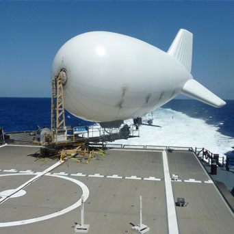
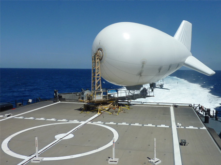
Raven Aerostar has integrated Septentrio’s AsteRX2eH into its tethered aerostat system.
Septentrio announced today that Raven Aerostar, a manufacturer of Lighter-Than-Air (LTA) platforms, has successfully integrated Septentrio’s AsteRx2eH, a single-board dual-antenna GPS/GLONASS heading receiver, into its tethered aerostat systems.
Raven Aerostar recently completed a maritime persistent surveillance solution demonstration, deploying a TIF-25K aerostat system aboard the High-Speed Vessel — SWIFT (HSV-2), during which the AsteRx2eH performed remarkably, according to the companies. Integrating the single-board AsteRx2eH dual-antenna receiver to replace a solution based on two separate GNSS receivers allowed Raven Aerostar to achieve a reliable and accurate heading solution while also decreasing deployment time and total cost of GNSS sensors.
The AsteRx2eH provides a compact and low-power solution for precise positioning combined with accurate heading information, produced at a high output rate. The tracking of both GLONASS and GPS satellites allows the receiver to improve the availability and robustness of a solution in challenging environments.
The AsteRx2eH is a globally acclaimed OEM solution with field proven performance for land, marine and aerial applications, Septentrio said. It is used onboard helicopters and aerostats during stabilized flights hovering at low dynamics, where inertial sensors cannot easily provide a drift free solution. Another application is delivering reliable heading information for driverless ground vehicles, even at very low speeds.
“From its user interface to its accuracy and durability, Septentrio’s AsteRx2eH receiver has proven to be an exceptionally stable system,” commented Patrick Lokken, Engineering Technician at Raven Aerostar. “We have integrated the AsteRx2eH into our lighter-than-air applications in multiple environments including desert and maritime, and have yet to see it falter.”
QinetiQ and Septentrio jointly announced today that a milestone in the Galileo European Navigation Satellite System’s development and deployment program has been achieved. On March 12, staff at the European Space Agency at ESTEC, Noordwijk, The Netherlands, achieved the first navigation solution using only the encrypted Galileo Public Regulated Service (PRS) signals broadcast by the four Galileo In-Orbit Validation (IOV) satellites launched in 2011 and 2012. Septentrio and QinetiQ, working in close partnership, developed one of the two PRS test user receivers used in this historic first test.
PRS positioning was achieved using the Galileo PRS Test User Receiver (TUR-P) jointly developed by Septentrio and QinetiQ under an ESA contract. For the reception test, the receiver was installed in the PRS test facility in ESTEC and operated by technical experts from ESA. Positioning accuracy of ~10 meters was achieved, excellent for a first test so early in the system’s deployment. The TUR-P now continues to be used as part of the campaigns running during the Galileo In Orbit Validation Phase.
This milestone builds on a number of previous major Septentrio/QinetiQ achievements including:
First laboratory demonstration of the PRS signal acquisition and tracking in QinetiQ (Malvern, UK, 2006).
Successful RF compatibility test between a Galileo payload and the TUR-P (Portsmouth, UK, 2010).
Successful Galileo end-to-end system test including the Galileo Ground Mission Segment (GMS) and its key management facilities, satellite and TUR- P (Rome, Italy, 2011).
First successful reception and processing of the PRS signal from space (Fucino, Italy, 2012).
As key, long-term contributors to the Galileo program, Septentrio and QinetiQ have worked closely with ESA, the European GNSS Agency (GSA) and European industrial partners since 2003.
“Following last year’s first successful reception and processing of PRS signals from Galileo satellites, I am very pleased to see the program moving forward successfully,” said Leo Quinn, CEO of QinetiQ. “Achieving a first PRS-only Galileo navigation solution is a major achievement. With positioning, navigation and timing services increasingly critical to the safety, security and economic activity of UK and our European neighbours QinetiQ are very proud to be contributing to the development of Europe’s first secured satellite navigation services.
“This milestone is another important step towards the launch of operational Galileo services and will continue to build confidence in both prospective users and the industrial supply base. It showcases QinetiQ’s capabilities in this field and signals the way towards the production of exciting new solutions for critical navigation and timing applications.”
“Today, together with our partners, we take another decisive step in the early availability of commercial PRS receivers and Septentrio is extremely proud of this historic milestone for the Galileo program,” commented Peter Grognard, Septentrio’s founder and CEO. “This builds on a list of major achievements for Septentrio since the reception of the first Galileo signal from space in 2006. We are delighted to continue the excellent collaboration with ESA and to contribute to this ambitious European project.”


 QinetiQ