Septentrio this week is launching two successors to its APS-U: The AsteRx-U and the AsteRx-U Marine multi-constellation dual-antenna receivers. The AsteRx-U will be presented to the public for the first time at two trade shows this week. ION GNSS+ takes place Sept.14-18 in Tampa, Fla., and INTERGEO 2015 will be held in Stuttgart, Germany, Sept. 14-18.
The AsteRx-U and the AsteRx-U Marine incorporate the latest GNSS tracking and positioning algorithms and interference mitigation. Machine-control users in the agricultural and construction industries, as well as users in marine and mining industries, benefit from a complete system with integrated UHF radio, Wi-Fi, USB, Bluetooth and cellular connectivity and a spectrum analyzer, Septentrio said. All configurations can be done via the on-board web interface.
The AsteRx-U and AsteRx-U Marine feature a full range of positioning techniques and algorithms to ensure that users have the highest accuracy and reliability. The spectrum analyzer enables users to visualize the RF spectrum. Based on its extensive experience with real-life interference sources and their mitigation, Septentrio has developed interference mitigation technology that automatically counteracts various kinds of ambient intentional and unintentional RF interference.
The AsteRx-U family of receivers is built around Septentrio’s latest ASIC, GReCo4, which was introduced in 2014. It incorporates built-in jamming detection and countermeasures, multi-path rejection, fast acquisition and other advanced features. Both receivers have more than 500 hardware channels to track all available constellations (GPS, GLONASS, Galileo, Beidou, IRNSS and QZSS) and feature many algorithms: LOCK+ technology to maintain tracking during heavy vibration machine use and IONO+ technology to assure the accuracy of the position even in regions of elevated ionospheric activity.
The AsteRx-U has decimeter- and centimeter-level RTK positioning including TerraStar. The AsteRx-U Marine also supports Veripos PPP augmentation services. It includes extra anti-jamming technology to counter Iridium and INMARSAT-uplink interference, as well as an extra antenna connector for a dedicated L-band antenna to optimize L-band reception at high latitudes.
Straightforward to set up and integrate with existing systems, the AsteRx-U and AsteRx-U Marine use any device with a web browser to facilitate usability and configuration for the user.
“We want to make it easy for our customers to use high-accuracy positioning in their work,” said Jan Leyssens, Septentrio product manager. “Using the integrated communication functionality in the compact and portable AsteRx-U, users won’t have to worry about adding their own modems or UHF radios to get access to corrections.”
Leyssens continued, “The receiver web interface is available wirelessly on any mobile device. It was designed together with several of our key customers, resulting in an interface that is not only easy to use by field operators, but also provides many useful troubleshooting tools, such as the spectrum analyzer, to solve problems in the field and minimize downtime.”
Septentrio will be at Booth 318 at ION GNSS+, and at Hall: 4, Booth: D4.014, at INTERGEO.
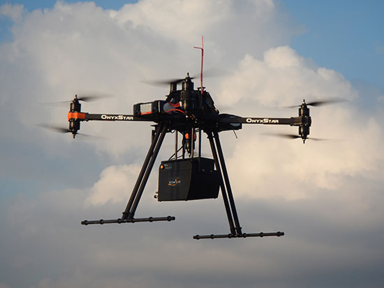
SBG Systems joins YellowScan to present a lightweight lidar with inertial and GPS for UAVs. The new product will be presented at the INTERGEO trade show in Stuttgart, held Sept. 15-17.
The YellowScan lidar is designed for fixed or rotary-wing UAVs, with an embedded Ellipse-E, a miniature inertial navigation system from SBG Systems, which helps obtaining a clear and accurate point cloud.
The UAV market is continuously growing, especially for professional applications like 3D surveying. Developed for such applications, YellowScan’s R&D team has worked closely with researchers and professionals in industries such as construction, surveying, mining and natural resources to create a comprehensive, high-performance and easy-to-use LiDAR.
Ellipse-E. The ready-to-use YellowScan is operational at up to 75 meters and delivers a highly dense point cloud accurate to 10/15 centimeter. The solution includes a lidar with a ±50 degree angle that measures 40,000 points per second, an Ellipse-E inertial navigation system coupled with a centimeter-level RTK GPS, an on-board computer, and an integrated battery.
The Ellipse-E miniature inertial navigation system by SBG Systems.
Once mounted on the drone, the user pushes the yellow button and YellowScan is ready to survey. LED lights give useful information on YellowScan state, for instance if the GPS is receiving RTK corrections or not. The user can launch the UAV and begin the survey. Once the task accomplished, a USB stick is used for downloading the data. An office software visualizes the point cloud in a few clicks, before opening it in an industry specific software like Terrasolid, AutoCAD or ESRI.
The YellowScan research and development team was searching for a high-performance, light and ITAR-free inertial navigation system for motion compensation and data georeferencing. They tested the Ellipse-E, the new miniature inertial navigation systems from SBG. Weighting 12 grams as an OEM version, it provides roll-and-pitch data accurate to 0.2 degree. The heading is accurate to 0.5° with only one antenna. Indeed, the heading computation relies on GPS and accelerometers data. This method is used when GPS positioning is widely available and punctuated by frequent accelerations, such as turns. The R&D team found the test results satisfying, and a point cloud highly clean. “We are very satisfied with this little Ellipse-E. It perfectly matches our technical needs, and we even gained 5 percent on the total weight of the YellowScan,” said Tristan Allouis, CTO at YellowScan.
Ellipse-E Coupled with External GPS Receiver. The Ellipse-E inertial navigation system is able to connect to any survey-grade GPS receiver and to fuse in real-time GPS position with inertial information. Ellipse-E maintains a reliable position even if GPS masks occur. In this application, the Ellipse-E is coupled with the AsterX-m OEM card from Septentrio, a receiver that uses GPS and GLONASS constellations and works with all types of RTK reference stations.
At INTERGEO, YellowScan will be in booth # F8.014, and SBG Systems will present the Ellipse-E at booth # G4.079.
Septentrio, a designer and manufacturer of GNSS receivers, has launched a new software suite called PinPoint-GIS, which is designed to make GIS data collection and visualization straightforward. Septentrio’s PinPoint-GIS provides several methods of data collection, based on a standard web browser hosted on the Altus APS-NR2 and a mobile app integrated with Esri’s ArcGIS or other GIS mapping systems.
Users of PinPoint-GIS benefit from bringing the data-collection process into their familiar GIS environment, Septentrio said. Data collected with Altus and Septentrio receivers is directly available in the user’s GIS application. This data is processed into the database without any intermediary steps, greatly reducing the time and complexity of the collection process for the user. This allows the user to focus on the project objectives by easily customizing and updating maps instead of losing time on the mechanics of data collection and transmission.
Altus APS-NR2 and GeoPod are well known for providing consistent and accurate data. Thanks to PinPoint-GIS, this data becomes seamlessly integrated with the GIS database. The data becomes easily accessible to the field worker though existing hardware such as commercial and ruggedized mobile devices, regardless of their operating system.
“By introducing PinPoint-GIS, Septentrio is committed to making accurate and reliable GIS collection as simple and cost effective as possible. Once installed Pinpoint GIS works without user involvement to place high quality positions into the users existing GIS data collection tools by using the three components of the software,” said Gustavo Lopez, PinPoint-GIS product manager. “Thanks to PinPoint-GIS, Septentrio provides a seamless interface for capturing data in the field, customizing maps, access to data and user functionality. More field workers can get greater productivity from their existing GIS tools.”
Septentrio will be presenting PinPoint-GIS at Esri AEC Summit, held at the Manchester Grand Hyatt July 18-21, and at the Esri User Conference, held July 20-24. Both events take place in San Diego, Calif.
Septentrio Satellite Navigation has completed the acquisition and integration of Altus Positioning Systems. Septentrio said the acquisition strengthens the company’s focus on highly accurate and reliable GPS/GNSS positioning equipment, and the integrated company will continue to focus on developing emerging markets across the globe and increase advancements in the field of GIS.
“At the heart of this fusion are our customers,” said Antoon de Proft, CEO and president of Septentrio, “They will benefit from this unique opportunity, which combines the knowledge and experience of Septentrio in GNSS positioning with experience of Altus-PS in survey, mapping and GIS; and from an expanded offering of products and services under one group.”
Septentrio Satellite Navigation and Altus-PS started working together in 2007. The collaboration between the two companies resulted in a series of successful products such as the APS-NR2, APS-3, APS-U and APS-GeoPod, surveying and GIS products that provide essential accurate and reliable results and ease of operation, Septentrio said in a statement. The smart antenna products will form a product line in the Septentrio product portfolio.
The acquisition brings key capabilities and synergies in other areas such as testing, manufacturing and delivery, which will now be based from Septentrio’s corporate headquarters outside the Belgian city of Leuven.
Neil Vancans
Neil Vancans, formerly president of Altus-PS, now becomes vice president of Septentrio Americas. “The fusion of our two companies is a logical step in our evolving business relationship and professional collaboration,” Vancans said. “We look forward to leveraging the strengths of both our organizations to grow the market for Septentrio products across a wide range of market sectors and build the same level of success for Septentrio products in the American market that we have enjoyed elsewhere in the world.”
Septentrio designs, manufactures and sells high-precision multi-frequency, multi-constellation GPS/GNSS equipment used in demanding applications in a variety of industries such as marine, construction, agriculture, survey and mapping, GIS and UAVs. Septentrio receivers are available as OEM boards, housed receivers and smart antennas.
In this special section, GPS World focuses on automous positioning and navigation technology, including unmanned aerial vehicles (UAVs), unmanned aircraft systems (UAS) and unmanned ground vehicles (UGVs).
SenseFly Launches Intelligent Mapping and Inspection Drone
SenseFly launched the eXom, a quadcopter for mapping and inspection, at the AUVSI Unmanned Systems show, held May 4–7 in Atlanta.
The 3.7-pound quadcopter offers professionals such as civil engineers and land surveyors the situational awareness, imaging flexibility and durability they need for challenging tasks, senseFly said. The sensors — GPS, inertial measurement units, barometers, magnetometers and magnetic encoders — maximize stability and safety.
Septentrio Launches UAS Receiver, Software for Drones
The AsteRx-m UAS by Septentrio.
Septentrio has launched the AsteRx-m UAS, an RTK-accurate GNSS receiver solution specially designed for the drone market. The AsteRx-m UAS provides high-accuracy GNSS positioning with low power consumption, according to Septentrio.
The launch of the AsteRx-m UAS board is complemented by the release of GeoTagZ software suite. The GeoTagZ suite works with the UAS camera and image-processing solution to provide centimeter-accurate position tagging of images without the need for a real-time data link.
Despite being Septentrio’s smallest receiver, the AsteRx-m UAS provides consistent, robust and accurate positioning from Septentrio’s in-house GNSS+ algorithm technology. The receiver delivers cm-level accuracy at less than 600 mW with GPS and less than 700 mW with GLONASS.
Kairos Kit Makes Vehicles Unmanned
Kairos Autonomi’s Pronto4 robotic applique kit is an add-on vehicle autonomy system that provides unmanned capabilities to current manned vehicles, rendering them optionally unmanned. Pronto4 delivers the torque needed to control traction, braking, throttle and implements in heavy vehicles and equipment, as well as smarter robotic functions such as GPS path following and supervised autonomous behaviors. The kit can be installed in any heavy vehicle or machine, rendering that vehicle optionally unmanned, and the equipment can still operate manually.
Applications include government and academic research and development; military training and testing; range clearance; mining; and tactical military uses.
Kairos displayed its Pronto4 unmanned kits at May’s AUVSI show.
Exelis, FAA Test Sites to Research Safety
Exelis has signed agreements with four FAA-designated UAS test sites for airspace situational awareness and research. The research will use the Exelis Symphony RangeVue sense-and-avoid tool to aid in safe integration of unmanned aircraft into the national airspace. The test sites will gain situational awareness of the range airspace via Symphony RangeVue, while Exelis gains product feedback. Symphony RangeVue enables UAS operators to access real-time and historical surveillance information via a web-hosted platform, helping to manage mission operations across multiple locations.
FAA Names MSU as Its Center of Excellence
The FAA has selected a Mississippi State University team as its Center of Excellence for Unmanned Aircraft Systems (COE UAS). The COE will focus on research, education and training in areas critical to safe and successful integration of UAS into the nation’s airspace.
Bipartisan Bill Would Expedite Exemptions
Sen. Cory Booker (D-N.J.) and Sen. John Hoeven (R-N.D.) have introduced the Commercial UAS Modernization Act, which would set temporary rules for those who want to fly commercial unmanned aircraft systems before the FAA establishes permanent laws regarding drone use. The senators believe the U.S. is falling behind other countries when it comes to creating rules for commercial drones.
Septentrio’s Jan Van Hees talks about the AsteRx-m UAS, an RTK-accurate GNSS receiver solution specially designed for the drone market launched at Unmanned Systems 2015, held May 4-7 in Atlanta. The AsteRx-m UAS provides high-accuracy GNSS positioning with low power consumption, according to Septentrio.
Septentrio has launched the AsteRx-m UAS, an RTK-accurate GNSS receiver solution specially designed for the drone market. The AsteRx-m UAS provides high-accuracy GNSS positioning with low power consumption, according to Septentrio.
The launch of the AsteRx-m UAS board is complemented by the release of GeoTagZ software suite. The GeoTagZ suite works with the UAS camera and image-processing solution to provide centimeter-accurate position tagging of images without the need for a real-time data link.
The AsteRx-m UAS will be on display at booth #635 during AUVSI’s Unmanned Systems 2015, held May 4-7 at the Georgia World Congress Center in Atlanta.
Despite being Septentrio’s smallest receiver, the AsteRx-m UAS provides consistent, robust and accurate positioning from to Septentrio’s in house GNSS+ algorithm technology. The receiver delivers cm-level accuracy at less than 600 mW with GPS and less than 700 mW with GLONASS. LOCK+ technology guarantees tracking under heavy usage and IONO+ guarantees no interference in challenging ionospheric conditions, Septentrio said.
Integration into Any UAS. One of the key characteristics of AsteRx-m UAS and GeoTagZ is the seamless integration into any UAS. AsteRx-m UAS features standard connection functionality that directly connects to a UAS autopilot, such as Pixhawk and Ardupilot. The power comes directly from a number of power sources, including micro USB, a 9-30V external power supply or the vehicle power bus. GeoTagZ is available as a library of software to integrate into an UAS image-processing tool chain.
“We want to make UAS-based data collection and processing extremely simple. AsteRx-m UAS and GeoTagZ do just that,” said Jan Leyssens, commercial product manager at Septentrio. “The GNSS board connects seamlessly to standard hardware and cameras used on a drone. Together with our software, we provide a data collection solution that provides cm-level accuracy without the need for ground control points or real-time data links, and that integrates effortlessly with an existing UAS image processing software solutions.”
The monitoring station in Brazil uses a Septentrio PolaRxS receiver to monitor the ionosphere, a Septentrio AsteRx3 to perform tests static and kinematic tests, and three RTK Altus APS3 receivers (one as a base station and two as rovers.)
After 27 months of intensive research, a project team funded under the European Union’s 7th Framework Programme has come up with a solution to counter the problem of ionospheric disturbance affecting GNSS signals.
The CALIBRA project recently showcased a commercially applicable approach to mitigate the phenomenon’s impact on high-accuracy GNSS positioning techniques. In two demonstrations, the project’s newly developed algorithm was successfully tested in actual precision agriculture and offshore operations.
Solar flares can cause ionospheric disturbance, a sudden increase in radio-wave absorption that often delays the propagation of signals and ultimately affects positioning. The problem has kept researchers busy for years.
The CALIBRA project team has been participating in this global research effort by focusing on Brazil, which is one of the most exposed regions due to its proximity to the magnetic equator. Add to this that the sun is at its peak of activity since it entered its new 11-year cycle in 2010.
The project achieved three main milestones. First, the team confirmed that ionospheric scintillation and variations in total electron content (TEC) had a direct impact on the functioning of high accuracy GNSS techniques, such as Precise Point positioning (PPP) and real-time kinematic (RTK) positioning. Then a suitable metric was established to characterize these ionospheric disturbances. Finally, the project produced a short-term empirical model for forecasting TEC and scintillation. A regional TEC map was developed which proved advantageous for use in Brazil and, to counter scintillation, a number of approaches for the mitigation of this phenomenon were proposed and their benefit demonstrated.
The project exploited the CIGALA-CALIBRA network and database — a network of ionospheric scintillation monitor receivers with a web interface (the ISMR Query tool), which collects more than 10 million observations on GPS, GLONASS, Galileo, BeiDou and other global navigation systems every day. Since it was launched in December 2014, this data has helped assist users from more than 20 countries because of the software’s visualization and mining techniques.
In light of this success, CALIBRA partners INGV (Istitute Nazionale di Geofisica e Vulcanologia) filed a patent for their forecasting model, and a new spin-off company — SpacEarth Technology — was set up. SpacEarth’s main purpose is to secure the software’s commercialization in relevant applications and services, while also improving and adapting it to evolving market needs.
The project’s results promise to considerably reduce downtime and financial losses caused by ionospheric disturbance in Brazil and other regions of the world. Learn more about the project here.
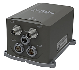
SBG Systems, a manufacturer of inertial navigation systems (INS), has selected the Septentrio AsteRx4 OEM GNSS receiver to equip its Apogee product line. The announcement was made during Ocean Business 2015, held April 14-16 in Southampton, England.
SBG Systems’ Apogee-D
“We are delighted that SBG Systems — a respected specialist in designing INS/GNSS — endorses our newly released GNSS receiver for its performance,” said, Laurent Le Thuaut, business development manager at Septentrio. “The SBG products are recognized amongst the preferred choice for accurate MEMS-based INS and we are extremely proud that our technology is included in their top of the line.”
Apogee is a new product line of high-accuracy inertial navigation systems based on robust and cost-effective MEMS technology. The INS/GNSS solution combines the latest generation of MEMS sensors and the OEM version of the AsteRx4, a newly introduced high-precision GNSS receiver from Septentrio. The Apogee series is especially suited for applications such as hydrography, mobile mapping and aerial survey where survey-grade positioning measurements are required.
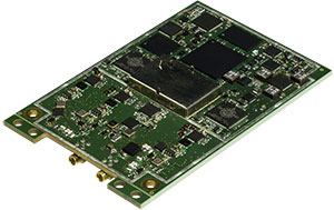
AsteRx4 OEM
The AsteRx4 OEM is a multi-frequency and multi-constellation dual antenna receiver that incorporates the latest innovative GNSS tracking and positioning algorithms from Septentrio. The AsteRx4 is scalable to one centimeter and integrates the entire suite of GNSS+ algorithms proposed by Septentrio to maintain tracking during heavy vibration of machines. This assures position accuracy under difficult ionosphere conditions and mitigates or rejects intentional or unintentional interference with GNSS signals.
“The compact design and the practical and well-designed interface of the AsteRx4 allowed a seamless and an easy integration into our solutions” said Raphaël Siryani, chief marketing & sales officer of SBG Systems. “The AsteRx4 largely contributes to the robust and accurate heading as well as the reduced power consumption of the INS/GNSS Apogee products.”
Both the AsteRx4 OEM receiver and the Apogee INS/GNSS are on display at booth No. W40 (Septentrio) and booth E5c (SBG Systems) at Ocean Business.
Septentrio has launched its next-generation dual-antenna GNSS receiver, the AsteRx 4 OEM. The AsteRx 4 OEM is a multi-frequency, dual antenna receiver that incorporates the latest innovative GNSS tracking and positioning algorithms from Septentrio. It offers users in the marine, machine control and agricultural industries precision, accuracy, reliability and ease of use, the company said.
Thanks to Septentrio’s positioning engine, which uses advanced multipath and ionosphere modeling algorithms, the AsteRx4 offers robust positioning scalable from meter to centimeter accuracy. Together with precise heading and reliable error estimates, the AsteRx 4 OEM functions in tough conditions on land, at sea or in the air.
Use of all available constellations (GPS, GLONASS, BeiDou, Galileo) provide the operator with a reliable solution even in obstructed areas such as in narrow city streets or at the corners of large structures, Septentrio said. The AsteRx4 OEM features the full range of positioning techniques from stand-alone to real-time kinematic (RTK).
For users who operate in more remote regions of the globe, the AsteRx4 OEM supports Veripos and Terrastar correction PPP services. Furthermore, the receiver features special interference mitigation technology which filters out ambient intentional and unintentional RF interference.
The AsteRx4 OEM is straightforward to set up and integrate with existing systems, Septentrio said. It has the similar hardware interface as earlier AsteRx receivers, and supports the same open and well documented command and binary output format. Users will be able to operate their receiver without special configuration software by using the very accessible web interface, which is available via network and USB connections.
“AsteRx4 incorporates many powerful improvements based on practical difficulties our customers face in the field every day,” said Jan Van Hees, vice president of Business Development, Septentrio. “We are particularly proud of the solutions for interference robustness that we have incorporated into our new ASIC, the GReCo4; the solid and reliable positioning algorithms that result from taking the receivers into the most extreme environments and from focusing not only on accuracy, but on reliability of the position solution.”
The AsteRx4, along with all the AsteRx family of receivers, will be on display at booth W40 for the duration of Ocean Business 2015 starting April 14 at the National Oceanography Centre, Southampton, UK.
The GPS World Galileo Product Showcase, from the April 2015 issue, features the latest products from seven top companies.
GPS/GLONASS/Galileo Receiver
Septentrio AsteRx3 Photo: Septentrio
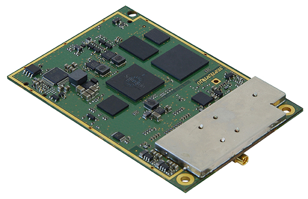
The AsteRx3 is a multi-frequency GPS/GLONASS/Galileo receiver is designed for demanding industrial applications. AsteRx3 features simultaneous high-quality GPS, GLONASS and Galileo tracking and a range of innovative features, such as the patented Galileo AltBOC tracking, the advanced multipath mitigation algorithm APME, LOCK+ tracking for exceptional tracking stability under high vibration conditions, RTK+ for extended RTK baselines and faster initialization, and AIM+, Septentrio’s Advanced Interference Mitigation technology, offering centimeter-level measurement quality for high-precision positioning, even in challenging environments.
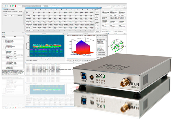
The IFEN SX3 multi-GNSS software receiver Photo: IFEN
IFEN’s SX3 multi-GNSS software receiver tracks all known GNSS signals in view, including Galileo signals, in real time on a standard laptop now and in the foreseeable future (up to 1,000 channels in parallel on a core i7). The included RF front end offers four RF frequency paths with 50-MHz bandwidth each, covering the entire GNSS L-band spectrum. The USB 3.0 interface enables high-speed data transfer with up to 8-bit quantization. An optional dual RF input front end can be used for attitude determination, reflectometry and other applications requiring the synchronized input from two antennas. An optional built-in shock and vibration robust OCXO reference oscillator (MIL-STD 202G) is available, which replaces the standard high-quality TCXO normally used.
The SX3 software lets users configure the data processing, including changing loop bandwidths, integration times and the main processing rate, and choosing between different correlation types. The software includes a multi-correlator providing a two-dimensional (code and Doppler) correlation function visualization in real-time. The receiver comes with several powerful processing algorithms like vector tracking, to improve the tracking of weak signals in degraded environments.
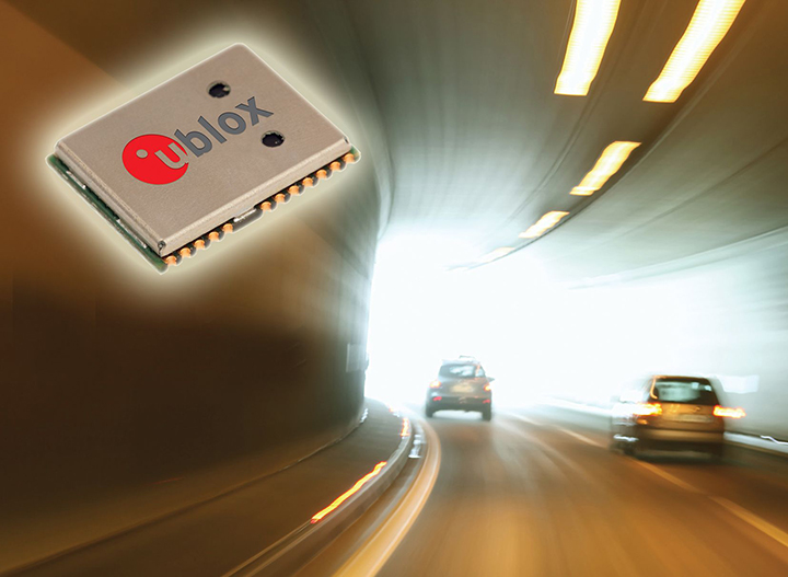
The NEO-M8L Automotive Dead Reckoning (ADR) module by u-blox has integrated motion, direction and elevation sensors. The module integrates gyro and accelerometer with u blox’ GNSS platform M8 to achieve high indoor/outdoor positioning performance for road vehicle and high-accuracy navigation applications.
The module is able to track all visible GNSS satellites including GPS, GLONASS, BeiDou, QZSS and all SBAS, with Galileo to be supported in a future firmware version. Concurrent reception of two GNSS systems is supported. The NEO-M8L module can output a position up to 20 times per second.
In addition to accessing the integrated module’s gyro and accelerometer data, accident reconstruction systems can provide the location of an accident to facilitate insurance claims even if a collision occurs in a tunnel or park house. High-end navigation devices are able to guide drivers through tunnels of several kilometers because of the accuracy of u-blox’ ADR system. Stolen vehicles can be located instantly due to continuous monitoring of sensor data and storage of location in non-volatile memory.
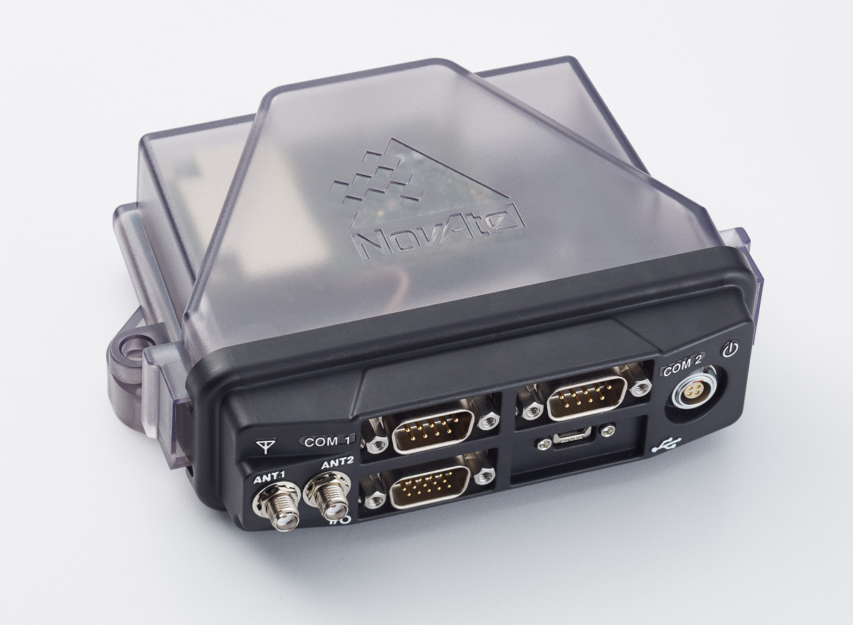
The NovAtel FlexPak6D enclosed GNSS receiver is a flexible dual-antenna solution for application developers seeking a high-precision heading-capable positioning engine for space-constrained applications.
Designed for efficient and rapid integration, the compact receiver tracks Galileo as well as GPS, GLONASS and BeiDou. Antenna placement is flexible: the antenna baseline can be set according to space available on a vehicle and heading accuracy required. The modular OEM6 firmware enables users to configure the receiver for unique application needs. Scalable for sub-meter to centimeter-level positioning, the FlexPak6D delivers NovAtel’s ALIGN precision heading and relative heading firmware, as well as its GLIDE firmware for smooth decimeter-level pass-to-pass accuracy and RAIM for increased GNSS pseudorange integrity.
The GNSS simulator in the vector signal generator R&S SMBV100A Photo: R&S
The GNSS simulator in the vector signal generator R&S SMBV100A is designed for development, verification and production of GNSS chipsets, modules and receivers. The simulator supports all possible scenarios, from simple setups with individual, static satellites up to flexible scenarios generated in real time with up to 24 dynamic Galileo, GPS, GLONASS, BeiDou and QZSS satellites. The simulator also supports Assisted GNSS (A-GNSS) test scenarios, including generation of assistance data for Galileo.
The simulator offers real-time simulation of realistic constellations with up to 24 satellites and unlimited simulation time. Flexible scenario generation includes moving scenarios, dynamic power control and atmospheric modeling. Users can configure realistic user environments, including obscuration and multipath, antenna characteristics and vehicle attitude.
The all-in-one TRIUMPH-LS by JAVAD GNSS combines a high-performance 864-channel GNSS receiver, all-frequency GNSS antenna, and a modern featured handheld. The 864 all-in-view channels include Galileo E1/E5A/E5B, GPS L1/L2/L5, GLONASS L1/L2/L3, QZSS L1/L2/L5, BeiDou B1/B2 and SBAS L1/L5.
The TRIUMPH-LS offers GUIDE data collection, Visual Stake-out (VSO), navigation, six parallel RTK engines, more than 3,000 coordinate conversions, advanced CoGo features, and rich attribute tagging on a high-resolution, bright, 800 x 460 bright display. Two 3-megapixel cameras enable recording of images along with GNSS data.
With VSO, the virtual location of a point to be staked can be seen by a “flag” shown on the Triumph-VS camera image. This visual aid helps users navigate quickly to a point and makes stakeout jobs fast and easy. VSO can be used as a convenient way to get close to a target point before switching to the regular stakeout mode to perform precise measurements.
More than 100 channels are dedicated to continuous interference monitoring. The Triumph-LS monitors and reports interference graphically and numerically with patent-pending interference protection. Interference awareness allows safe GNSS operation in a city, airport and military environment.
The unit can serve as base or rover. It has a GSM modem, UHF transmit and receive, and an internal high-performance geodetic antenna.
The TRIUMPH-LS automatically updates all firmware when connected to a Wi-Fi Internet connection.
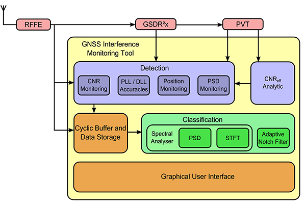
TeleOrbit’s software-defined radio receiver and GNSS interference monitoring tool receives and processes all available Galileo signals. Signals that are not yet transmitted and interference sources can be simulated and processed within the software tool.
Within a software-defined radio framework, the analog-to-digital converter is moved as close as possible to the antenna to perform most of the signal processing in software. This leads to adaptable solutions with lower hardware costs that can be easily extended to new signals and systems with only a software update.
The GNSS Software Defined Radio Receiver (GSDR2X) developed by TeleOrbit’s sister company TeleConsult Austria can track most readily available signals from Galileo, GPS and SBAS. By utilizing input from TeleOrbit’s GNSS multi-system performance simulation environment (GIPSIE), even signals not yet transmitted by satellites can be tracked and processed by the GSDR2X. Furthermore, input data can be read from various radio frequency front-ends, either directly or from file.
The modular GSDR2X framework enables new capabilities, such as the GNSS Interference Monitoring Tool (GIMT), which enables the GSDR2X to detect and classify interfering and jamming signals (see figure).
DigPilot, a Norwegian supplier of surveying equipment and instruments for building and construction, has developed a flexible 3D machine guidance system based on Septentrio’sAsteRx2eH OEM GNSS receivers.
AsteRx2eH is a single-board dual-frequency dual-antenna 272-channel GPS/GLONASS OEM heading receiver, which provides 20-Hz data output of position, heading and pitch/roll data to the machine guidance system. As a member of Septentrio’s AsteRx family of compact OEM boards, the AsteRx2eH receiver is built around the same advanced GNSS chipset and shares the family’s all-in-view GPS and GLONASS tracking and advanced signal processing algorithms for robust tracking and high-precision positioning, even in challenging environments.
The DigPilot machine guidance system uses wireless technology for all of the installed sensors, instead of being hard-wired into the machine. All the components come packed in a hardened plastic case for transportation from one machine to another. The sensors can be clipped into brackets on the excavator arm and cab and calibrated to the machine and bucket in a matter of minutes, Septentrio said. The operator uses an intuitive graphics display on a rugged touchscreen console to control the arm and shovel following a preloaded grade plan.
The DigPilot machine guidance systems have been documented to improve on-the-job safety, productivity and quality of work while reducing costs dramatically. With the DigPilot system, companies can move the 3D guidance system around the fleet of construction equipment as needed, at a fraction of the cost of installing hard-wired systems on multiple machines, Septentrio said.
DigPilot customers are also using APS-3 GNSS RTK receivers from Altus Positioning Systems, a Septentrio company, in conjunction with the on-board machine guidance system for high-precision site surveys and as-builts.
“With the Septentrio OEM receivers we know we can count on the highest levels of accuracy, reliability, ruggedness and performance,” said Jan Floberg, CEO and founder of DigPilot. “We tested all other available GNSS products on the market before deciding on Septentrio. The AsteRx2eH outperforms the other brands in its ability to obtain and hold fix and heading in the rugged terrain of western Norway. We have deployed over 1,000 systems to date.”
Altus and Septentrio products will be on display at World of Concrete in Outdoor Booth 032025 at the Las Vegas Convention Center, Feb. 3-6.