HawkEye 360 has made powerful enhancements to its GNSS Interference (GNSS-I) Detection product suite. The upgrades — designed with defense, intelligence and national security operations in mind — offer unprecedented accuracy, coverage and insight into global GPS jamming and spoofing threats.
The update includes a new wider frequency algorithm that better distinguishes individual emitters, incorporates GPS spoofing detection, and is terrain adjusted for better geolocation accuracy, delivering greater situational awareness and more precise geolocation of interference sources worldwide.
HawkEye 360’s enhanced GNSS Interference Detection product suite supports strategic decision-making by providing timely, precise insight into potential signal disruptions, enabling stakeholders to better assess risk, respond confidently, and maintain operational continuity in dynamic environments.
With this release, HawkEye 360’s GNSS-I Detection product suite now provides:
15 times increase in geolocation density
Spoofing detection and differentiation
Terrain adjusted for increased accuracy
Consistent monitoring across wide areas of interest
HawkEye 360’s new spoofing detection capability identifies potentially malicious transmitters that imitate legitimate GPS course/acquisition (PRN) codes — a tactic increasingly used to deceive aircraft and mislead navigation systems. The capability supports threat mitigation and trend analysis by detecting and geolocating these spoofers down to a kilometer-level precision.
“In contested environments, timely RF intelligence is the key to mission success,” said Alex Fox, president, International Business Unit. “Traditional land, sea, and air systems struggle in Anti-Access/Area Denial environments, while our satellites provide global GNSS-I detection and geolocation coverage. These enhanced capabilities give defense and intelligence teams the ability to identify and neutralize threats before they disrupt operations, enabling faster decisions and sharper visibility into adversary behavior.”
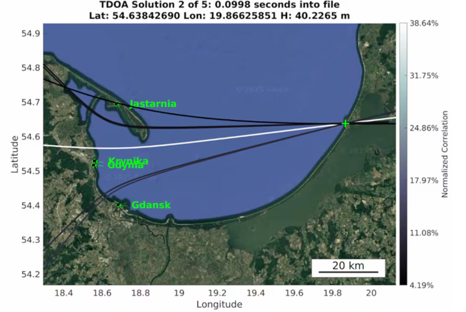
Radio waves emanating from secretive facilities run by Russia’s military are the culprit behind GNSS jamming in the Baltic Sea, according to Defense News.
The news outlet reports that Polish researchers collected jamming and spoofing information on incidents covering the Gdansk airport, shipping lanes, and the airspaces of Estonia and Finland. The interference has been recorded almost daily since Russia’s full-scale invasion of Ukraine in February 2022, resulting in flight cancellations, airport closures and commercial ships steering off track.
In March, eight European countries, including the Baltic states, Finland, Poland, France, the Netherlands and Ukraine, lodged a complaint with the UN about the practice. Several UN agencies have also taken up the issue, including the International Maritime Organization, the civil aviation authority ICAO and the International Telecommunications Union.
Russia, itself a Baltic Sea country, has not responded to the charges of interference. Likely origin spots include Kaliningrad, which is between Poland and Lithuania, and the St. Petersburg area. Both regions are known to have a heavy Russian military presence, including divisions specialized in electronic warfare.
News outlet MSN has published a slideshow detailing seven take-aways from recent GNSS spoofing defense moves against Iranian missiles headed toward Israel. The missiles instead ended up in the Mediterranean Sea, apparently because of successful electronic hacking.
“The incident has caused tremors within the defense and cyber-defense communities, pointing to the mounting sophistication of electronic warfare and the weakness inherent in contemporary navigation systems,” the report states.
The event is being studied as a sophisticated method that “deceived” the missile’s guidance, making it continue on a reasonable course while deviating it from its targeted direction, an advance in electronic warfare that requires knowledge of the missile’s flight algorithms.
“Spoofing detection is much more difficult than jamming, since spoofed signals are made to mimic legitimate signals. Sophisticated detection techniques, like those employing pseudorange difference and sum sequence linearity, are being researched to separate genuine from spoofed GNSS signals. These detection techniques examine the consistency and conduct of signal measures, searching for minute discrepancies that indicate spoofing efforts.”
Spoofing is also affecting civilian sectors, such as when cargo ships collided in the Strait of Hormuz. The International Air Transport Association and the European Union Aviation Safety Agency have published a comprehensive plan to mitigate risks stemming from GNSS interference. The plan was part of the conclusions from a jointly hosted workshop on the topic of GNSS interference.
Agencies also are seeking reliable countermeasures as well as complementary PNT such as magnetic navigation.
13 member states of the European Union have called on the European Commission to respond to interference with GNSS in EU countries.
The interference originates in Russia and Belarus, as a result of the ongoing war with Ukraine.
The ministers for transport from 13 countries urged immediate and coordinated action in response, reports the Baltic Times. The joint letter was signed by the ministers of Lithuania, Latvia, Estonia, Germany, Slovakia, Finland, Slovenia, the Czech Republic, Italy, the Netherlands, Spain, Denmark and Romania.
In the joint letter, the ministers emphasize that since 2022, two types of interference to GNSS — jamming and spoofing — have been observed in the airspace of the Baltic Sea Region, posing a threat to various modes of transport, particularly civil aviation and maritime navigation.
The General Secretariat of the Council of the EU responded to the joint letter with an outline of potential actions.
Evaluate and coordinate the possibility to suspend the right to Russia and Belarus in the ITU to register the use of radio resources while GNSS interference is in progress. The lack of procedural legislation cannot be an excuse for deliberately contravening the spirit of the ITU Constitution and its general principles, endangering public health and life, without suffering any consequences.
Based on good practice of EU and NATO cooperation on critical undersea infrastructure, enhance civil-military coordination mechanisms among Member States for shared monitoring, data exchange, and possible response to GNSS interference. Explore the benefits of dual use of various equipment and measures to combat the risks caused by GNSS interference.
Intensify RFI monitoring by eligible national organizations and bodies, e. g. national regulator, police and military, and aggregate non-classified information on observed RFI to a publicly available near real-time monitoring and alert service on European level.
Accelerate the deployment of interference resistant GNSS services, especially the antispoofing features that are part of the Galileo program, e. g. authentication and/or encryption of signals exchanged between stations and user equipment.
Reassess the current reliance on GNSS-based navigation and develop resilient Positioning, Navigation and Timing (PST) services by deploying alternative or complementary systems, including ground-based legacy solutions. Simultaneously, upgrade and modernize conventional navigation infrastructures to serve as robust backups.
Promote industry-manufacturer collaboration for mitigation tools and updates. Support operator-level reviews of backup system readiness, ensuring non-GNSS alternatives are usable and practiced. 2 TREE2B 9198/25 EN
Draw the attention of critical infrastructure operators and unmanned system manufacturers to the risks that may arise from interference with GNSS.
Develop action plans for different domains (space, aviation, maritime, telecommunications) to avoid potential duplication of efforts and coordinate short-term and long-term measures at EU and national level.
Continue cooperation with all relevant stakeholders (ITU, ICAO, IMO, EASA, EMSA, IATA, EUROCONTROL). These actions, among others, could contribute to building the overall resilience of the critical infrastructure and strengthening safety and security in Europe.
The letter highlights the urgent need to accelerate the deployment of interference-resistant GNSS services, enhance the overall resilience of critical infrastructure, and strengthen safety and security across Europe.
“The current security environment demands a unified response to hybrid threats posed by hostile regimes, as well as close cooperation to strengthen Europe’s preparedness and resilience,” said Lithuanian Transport and Communications Minister Eugenijus Sabutis.
“Disruptions to GNSS signals have a direct impact on strategic sectors such as transport, energy, and telecommunications. To prevent potential incidents, we must act swiftly and decisively at the European Union level — not individually, but in a coordinated manner,” Sabutis said.
The interference is not random incidents but a systematic, deliberate action by Russia and Belarus, which can be used as a hybrid attack on strategic radio spectrum, essential for modern technology, regional safety and security, particularly in transportation.
Furthermore, the ministers call on the EU to increase diplomatic efforts to address the interference and apply pressure on the responsible parties, including legal action against responsible individuals and entities involved in the deliberate interference with GNSS signals, to enhance European safety and security.
“So far, the attempts by several Member States to address the problem have not brought any more tangible results,” the EU General Secretariats said. “Therefore, it is necessary to increase diplomatic efforts to address the interference and put the pressure on the responsible parties.”
The ministers propose intensifying radio frequency monitoring and enhance civil-military coordination mechanisms among Member States for shared monitoring, data exchange and possible response to GNSS interference. They also advocate for accelerating the deployment of interference-resistant GNSS services, particularly the anti-spoofing features of the Galileo program, and for upgrading and modernizing conventional navigation infrastructure.
Reports of increased interference include:
Lithuania: starting from 556 cases in March 2024 to 890 in October 2024 and 1185 in January 2025
Latvia: 790 cases in October 2024 to 1288 cases in January 2025
Estonia: 1150 cases in October 2024 and 1085 cases in January 2025
Poland: 1908 cases in October 2024 to 2732 cases in January 2025.
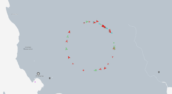
Russian jamming of GPS signals is suspected to be the cause behind a new “Bermuda Triangle” of navigation confusion in the eastern Baltic Sea.
In the Gulf of Finland, ships are disappearing from radar and Russian fighter jets are traveling through NATO airspace, according to Danwatch, a Danish news outlet.
Ship monitoring service MarineTraffic shows the position of ships in completely different places than their actual positions, currently on land east of coastal city Primorsk, Russia.
Experts say that not only is GPS being disrupted, but hackers are also manipulating navigation data. They blame Russia for its hybrid activities and attacks, which it carries out both from its mainland territory and from the Kaliningrad enclave, located between Poland and Lithuania.
Screenshot of MarineTraffic taken June 4, 2025, shows ships traveling in a circle on land, well east of the Baltic Sea.
Romania also has issues with Russian jamming and spoofing activities. The website Defense Romania quotes Gen. Gheorghiță Vlad, chief of the Romanian Defense Staff, who said jamming and spoofing has occurred on the Black Sea weekly since the start of Russia’s war with Ukraine. Also, Romanian defense forces have discovered 122 floating mines in the sea.
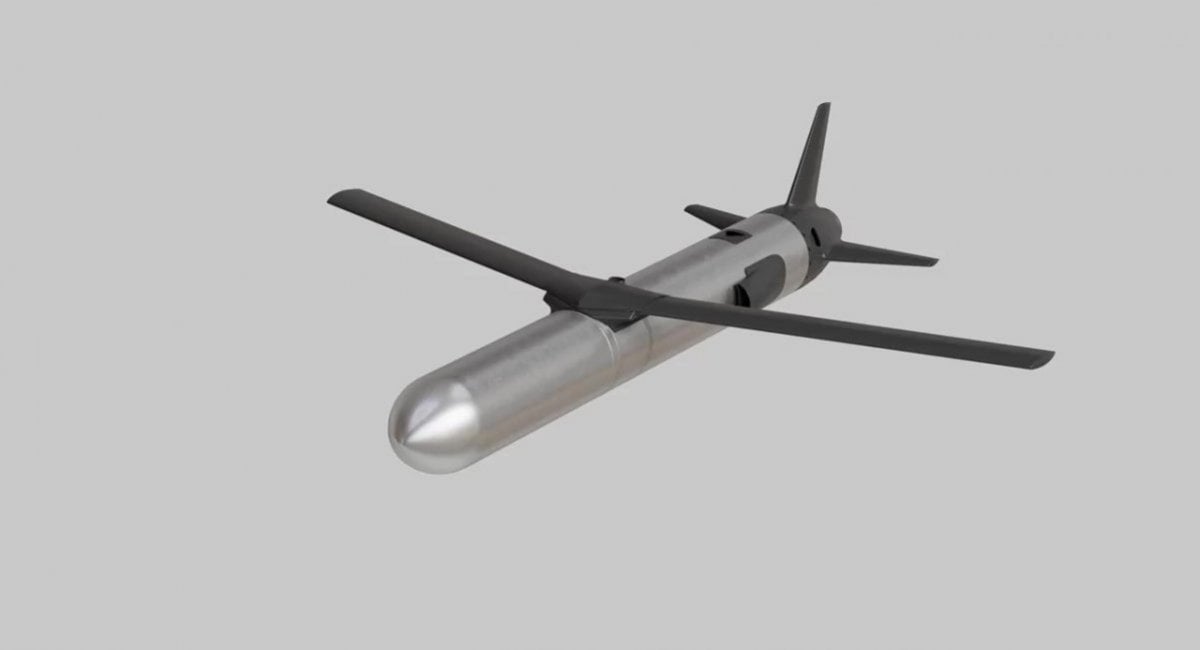
The Ruta OWA drone — actively used by Ukrainian forces for strikes at ranges up to 300 km — is being improved with a new visual navigation system, tested in combat conditions.
The Ruta, manufactured by Destinus, is essentially a miniature cruise missile. It is often referred to as a “missile drone.” It will receive a new navigation system enabling high-precision strikes in GPS-denied contested environments, especially those from enemy electronic warfare (EW) countermeasures.
The new navigation and guidance system will be provided by Spanish company UAV Navigation, part of Grupo Oesía, which entered an agreement with the Ukrainian Destinus on May 13.
The agreement will focus on Ruta in its first phase. Ruta is the first low-cost missile (LCM) drone developed by Destinus designed to operate in highly contested scenarios. The system incorporates an advanced guidance, navigation and control system, developed by UAV Navigation-Grupo Oesía, which has been validated in real-world combat conditions, including GNSS-denied environments or under jamming and spoofing attacks.
Ruta offers autonomous flight capabilities, target-referenced navigation, terminal optical guidance, and coordinated swarm operations, enabling the execution of complex synchronized attack maneuvers to saturate or deceive defense systems. The platform flies at a cruising speed of Mach 0.8, has a range of up to 500 km, and a terminal impact accuracy of 15 square meters.
On Sept. 1, 1983, Korean Air Lines flight KAL007, with 269 people on board, went 360 miles off course and strayed into prohibited airspace over one of the Soviet Union’s most sensitive military installations. The pilots, who had missed some radio calls and warning shots, were unaware. Then an air-to-air missile hit the plane.
This tragic Cold War episode helped GPS technology spread from military to civilian use because President Ronald Reagan’s deputy press secretary, Larry Speakes, said that to help prevent a repeat of the tragedy, “the President has determined that the United States is prepared to make available to civilian aircraft the facilities of its Global Positioning System when it becomes operational in 1988.” Civilian use of GPS had been envisioned from the program’s beginning, but Reagan’s announcement now guaranteed the future availability of GPS to civilians. That, and later smartphones, spawned the development of the commercial and consumer GPS industry.
More than 40 years later, however, civilian airliners are increasingly at risk of being shot down, as well as many other equally disastrous outcomes, due to spoofing and its percolating effects on many aircraft systems. GPS Spoofing: Final Report of the GPS Spoofing Workgroup, released on Sept. 6, reports a 500% increase in spoofing this year compared to last year, with an average now of 1,500 flights spoofed per day. Among the many dangers this poses, the report states that it has led to “aircraft entering other Flight Information Regions without clearance or authorization, which creates risk of misidentification and, in the extreme case, interception or shootdown.”
The report, based in part on a questionnaire returned by nearly 2,000 pilots — 56% of them working for airlines and 72% captains — found that more than 90% of all crew members rated their concern as moderate or higher. The three most insidious aspects of spoofing for aircraft are that pilots may not be aware of it; that GNSS receivers may continue to yield incorrect positions long after the aircraft leaves the spoofing area; and that bad data from the GNSS receiver has “severe and cascading effects” on many other systems, including the flight management system, the Ground Proximity Warning System, Hybrid IRS, the aircraft clock, weather radar, CPDLC, ADS-B and ADS-C. Spoofing also affects air traffic control, which is inundated with requests for radar vectoring during and after spoofing.
The report finds “an overall sense of complacency and muted interest across a broad section of the aviation industry.” Two of its many recommendations to mitigate the problem jumped out at me: synching a mechanical watch to a known source at dispatch “in preparation for aircraft clock failure” and positioning a handheld GPS receiver “low down in the cockpit such that it only has a direct line of sight to the highest elevation satellites,” which makes it possible “that it may not get jammed and spoofed as easily as the externally mounted antennas.”
Why has it come to this? What will we do about it? You can read the report here.
The civil infrastructures behind safety-critical applications in aviation, maritime and terrestrial navigation rely heavily on global navigation satellite system (GNSS) signals. The civil GNSS signal structures are vulnerable to spoofing attacks, which can endanger public safety.
In this work, the authors introduced an optimal cumulative position-domain innovation (CPI) monitor to detect spoofing by accumulating tracking errors embedded in the spoofer’s signal. The authors also derived relationships between missed detection probability, tracking error magnitude and monitor run time to show that even with decimeter-level tracking error, the monitor can detect spoofing with a low probability of missed detection in less than 1 minute.
The team of researchers evaluated the performance of the CPI monitor for both white and time-correlated (colored) tracking errors. To compute protection levels and detect short-duration spoofing, researchers proposed a complementary solution separation (SS) monitor to implement in sequential, overlapping windows to compare the integrated INS/GNSS position solution against an inertial navigation system (INS) coasting solution. The INS-only coasting element allows the system to maintain positioning continuity after detection, albeit at lower accuracy, as the INS drifts.
The experimental results indicate that implementing a CPI monitor can dismiss the conjecture that INS-based spoofing detection is susceptible to slowly deviating counterfeit signals. It was found that if the duration of the spoofing event exceeds a minimum time defined by the variance and time constant of the tracking error, the spoofer’s target tracking error can be detected.
Birendra Kujur, Samer Khanafseh and Boris Pervan; “Optimal INS Monitor for GNSS Spoofer Tracking Error Detection.”
Space-Time Adaptive Processing
Antenna arrays and spatial processing techniques are among the most effective countermeasures against GNSS signal interference. In this paper, the authors propose a new array concept, space-time adaptive processing (STAP), that consists of spatially distributed subarrays small enough to fit inside the non-metallic parts of an automobile. The device is designed to be installed in bumpers or side mirrors.
During the experimental testing, the authors used beamforming algorithms for the array to perform against jammers in the GPS L5 and Galileo E5a bands. The authors composed a GNSS jamming scenario to compare conventional space adaptive processing (SAP) methods and the new STAP method using real-life measurements in a dynamic scenario. In this simulation, the car was rotated 360° throughout the complete measurement. The comparison between the received signal quality demonstrated an improvement for wideband signals.
The results demonstrate that the performance of the STAP was dependent on the number of taps analyzed in the testing simulation that included different fractional delays. Overall, the research showed STAP could outperform SAP implementation in applications requiring robust tracking, as it was able to process all satellites for an additional 12 seconds.
Marius Brachvogel, Michael Niestroj, Michael Meurer, Syed N. Hasnain, Ralf Stephan and Matthias A. Hein; “Space-Time Adaptive Processing as a Solution for Mitigating Interference Using Spatially-Distributed Antenna Arrays.”
Enabling RTK Positioning Under Jamming
New GNSS applications demand high position accuracy and resilience against radio frequency interference. Separately, these demands can be fulfilled by multi-antenna systems using spatial filtering and carrier-phase positioning algorithms, such as real-time kinematics (RTK), respectively. However, combining these approaches creates a severe issue: the spatial filtering induces a phase offset into the measured carrier phase leading to a loss of position accuracy.
This paper presents a new approach to compensate for the phase offset without knowing the antenna array radiation pattern or the direction of arrival of the signals. The proposed algorithm was tested in two different scenarios using an in-house software receiver in combination with the RTKlib — an open-source program package for GNSS positioning — that was used to estimate an RTK solution. In the first scenario, the signal power of a jammer from a constant direction of arrival (DoA) was raised stepwise. In the second scenario, a jammer with constant signal power was moved around the receiver antenna array. For both scenarios, the proposed algorithm was compared with a multi-antenna system not compensating for the phase bias and with a single antenna processing.
It is most suitable in situations where a medium-to-high precision (dm to cm) solution must be resilient to interference. A very high precision solution (cm to mm), comparable with a geodetic receiver accounting for antenna phase center variations, cannot be achieved with this algorithm.
In this paper, the signal recording and processing time was limited to less than half an hour. The carrier-phase offset produced by the proposed algorithm may become larger over longer observation times. Evaluating this is part of future work.
Tobias Bamberg, Andriy Konovaltsev and Michael Meurer; “Enabling RTK Positioning Under Jamming: Mitigation of Carrier-Phase Distortions Induced by Blind Spatial Filtering.”
Several layers of defense can be implemented in a GNSS receiver to improve its performance in the presence of interference. These layers include the use of pre-correlation mitigation techniques, post-correlation quality indicators to screen measurements and fault detection and exclusion (FDE) at the position solution level.
This paper provides a characterization of the interactions between these layers of interference mitigation and a measurement quality check. Data collected in the presence of increasing levels of jamming were processed using different interference mitigation techniques, including robust interference mitigation (RIM) and the adaptive notch filter (ANF). A software-defined radio (SDR) approach was used, and measurements were generated by considering five interference-mitigation techniques. Position solutions were then computed using a forward-backward approach for receiver autonomous integrity monitoring (RAIM). Signals from GPS, Galileo and BeiDou were processed and both single and dual-constellation solutions were analyzed.
The results demonstrated that interference mitigation allowed the receiver to track a larger number of signals even in the presence of high levels of jamming power. This increased measurement availability was then effectively exploited by RAIM techniques to provide more reliable solutions. Measurements from several constellations further improved the reliable availability of the position solutions.
Ciro Gioia and Daniele Borio; “Multi-layered Multi-Constellation Global Navigation Satellite System Interference Mitigation.”
The high-accuracy service (HAS) offered by Galileo is now available and provides sub-meter accuracy over most of the globe. It will help enable emerging technologies such as UAVs and autonomous vehicles, which require stringent levels of accuracy for better navigation, safety and efficient traffic management.
Other industries expected to benefit include transportation, agriculture, geodesy and entertainment.
Thierry Breton, European commissioner for Internal Market, announced that the service was now live during the annual European Space Conference in Brussels, Belgium, on Jan. 24.
The European Union Agency for the Space Programme (EUSPA) developed Galileo HAS along with the European Commission and the European Space Agency (ESA). The new service will become a pillar of government programs such as EU sectorial policies and national policies by EU Member States.
“This new service has been made possible thanks to the outstanding cooperation and team commitment of all involved partners,” said Rodrigo da Costa, EUSPA executive director.
“Galileo is not standing still,” said Javier Benedicto, ESA director of navigation. “This new High Accuracy Service offers a new dimension of precision to everyone who needs it, while the Open Service Navigation Message Authentication — already available — allows users to authenticate Galileo signals as they make use of it, to minimize any risk of spoofing. An upgraded integrity message of the signal rolled out last year reduces the time to first fix while enhancing the overall robustness of Galileo.”
Galileo HAS delivers horizontal accuracy down to 20 cm and vertical accuracy of 40 cm in nominal use conditions, according to ESA. The service is transmitted directly via the Galileo signal in space (E6-B) and through the internet.
With HAS, Galileo becomes the first constellation worldwide able to provide a high-accuracy service globally and directly through the signal in space.
The service is freely accessible to all users with a receiver capable of processing the HAS corrections broadcast in the E6-B signal and via the internet. The precise corrections provided by Galileo HAS will allow users to reduce the error associated with the orbit and clocks provided through the Galileo Open Service broadcast navigation messages and the GPS Standard Positioning Service navigation data.
“With the Galileo HAS we are ready to unleash the full potential of new technologies such as drones and bring autonomous driving closer to reality,’’ da Costa said. “At EUSPA, our role is to link space to user needs. With the launch of this new service, we met a clear market demand for accurate, robust, and reliable navigation.”
Project GENIE (GNSS Excluded Navigation Intelligent Enhancement) will mature and advance non-GNSS solutions as part of a long-term objective to enable assured location and navigation in commercial aerospace, helping to unlock the benefits and value of autonomy in civil aviation. The support from NATEP will enable the consortium to take a significant step toward navigation in GNSS-spoofed or -denied environments, the companies said.
“Tomorrow, as we look towards single-pilot operation and future autonomous aircraft, there will not be a pilot or air traffic controller available to mitigate these risks,” stated the companies in a press release. “GENIE has been developed to step into this role. It will be able to identify when a GPS signal has been compromised and, using a combination of techniques, provide a location position as accurate as GPS.”
“The need to provide assured, resilient navigation is a critical enabler for autonomy in the aerospace environment,” said Charles Smith, CCO at Archangel Imaging. “GENIE is a core element of this, and we are very excited to be working with NATEP to help push this technology forward. We see significant commercial exploitation opportunities as a result of this project in the UAV and broader aviation markets and are thrilled to be a part of this round of NATEP funding and support.”
The launch of Xona’s test satellite begins a new era of innovation in assured PNT, with NovAtel receivers demonstrating early support of Xona’s signals
Hexagon | NovAtel has signed a memorandum of understanding with Xona Space Systems to collaborate in the positioning, navigation and timing (PNT) development of Xona’s new low-Earth orbit (LEO) constellation.
LEO constellations offer a new avenue of assuring PNT by providing stronger signals with satellites closer to Earth and improved positioning accuracy with rapidly changing geometry, NovAtel explained. Additional constellations and a larger number of available satellites improve visibility in cases where parts of the sky are obstructed by buildings and other obstacles.
Also, as the threat of unintentional or malicious jamming and spoofing increases, it becomes important to consider alternative sources of PNT and resiliency methods, the companies said.
“Precise and robust PNT forms the foundation for safe operation of modern applications such as automotive and autonomy,” said Brian Manning, CEO of Xona. “We are thrilled to be collaborating with NovAtel to demonstrate the benefits that our combined technologies can bring to these markets and many more.”
Xona’s new constellation will transmit encrypted signals on two frequencies, both offering authentication, further building new levels of resilience against malicious interference. NovAtel is an early adopter of Xona’s signals and an industry leader in resilient assured PNT.
“This agreement accelerates the future of alternative PNT,” said Sandy Kennedy, vice president of innovation at Hexagon’s Autonomy & Positioning division. “Our collaboration will demonstrate the complete assured PNT ecosystem that Xona has envisioned, and of which NovAtel is very excited to be part.”
Xona and NovAtel will be presenting innovations in assured PNT and the future of GNSS at the Autonomy & Positioning Reality Summit during HxGN LIVE Global in Las Vegas, June 20-23.
As PNT becomes critical to more economic activities, any disruption in availability, reliability, resilience and integrity would weaken the critical infrastructure that sustains national security, business operations and public safety, according to experts speaking at the Geospatial World Forum.
This growing dependency on PNT services — and the potentially high economic cost of vulnerabilities — underscores how vital GPS and GNSS systems are to the global economy and national security of countries worldwide, the experts said. Resilient PNT systems are necessary to combat GPS/GNSS outages.
Robert Cardillo (Photo: GWF)
Building resilience into these systems will require multiple technologies ranging from network time-transfer services to terrestrial wireless infrastructure and low-Earth-orbit (LEO) satellites.
The Geospatial World Forum opened in Amsterdam on May 10. The second plenary of the day focused on the value of PNT in the global economy. Geospatial World is a global think tank working towards raising awareness around the use of geospatial data and technologies among governments and policymakers, businesses, and the public at large.
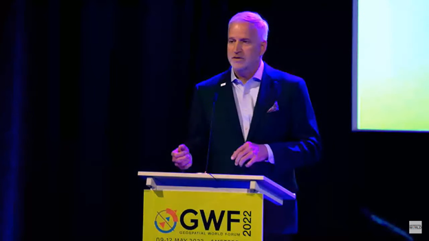
Robert Cardillo, president of The Cardillo Group and former director of the U.S. National Geospatial Intelligence Agency (NGA), headed the panel of experts.
“Our existence on this planet has been shaped by our individual and collective awareness of place and our confidence to be able to move securely and efficiently from one place to another, all within that common framework of position, navigation and timing, or PNT,” he said.
“The smartphone is a wonderful example of how far PNT has been integrated into our lives,” said Trimble founder Charlie Trimble. He laid down three basic phases involved in leading PNT to its place in the world economy.
“The path from the dawn of space age to the smartphone was anything but obvious or straightforward,” Trimble said. “First, Sputnik led to the global navigation systems. Second, the Shuttle disaster led us to the realization that the satellite system was an information utility. And now, the integration of PNT into the mobile and immobile internet is changing our world.”
From left: Charlie Trimble, Martin Sweeting, Rodrigo da Costa and Gillian Smith. (Photo: GWF)
“Our first contract was with ESA (European Space Agency) to look at the feasibility of using a navigation and timing satellite using small-satellite techniques, which in 1985 was considered a wacky idea,” recounted Martin Sweeting, executive chairman of Surrey Satellite Technology Ltd. “At ESA, we have embarked on a project called Hydro GNSS, which uses Surrey’s GNSS reflectometry to address several climate related issues, be it water detection or biomass, etc. This doesn’t stop here; we are looking at the lunar economy. PNT has indeed a very bright future, not just on Earth but also looking through this decade into the use of PNT on the lunar surface.”
Rodrigo da Costa
“New things are happening, particularly in the area of governmental satellite communications, space situational awareness and others, which are benefitting citizens every day,” said Rodrigo da Costa, executive director, EU Agency for the Space Programme (EUSPA). “Galileo, EGNOS (European Geostationary Navigation Overlay Service), Copernicus and GOVSATCOM programs are key areas of EU space activities. All these programs are massive investments and in the end, the result comes from their utilization in the different areas of our economy and daily life.”
“Just in the United States alone, GPS is approaching USD 1 trillion in terms of economic impact and is doubling every 2-3 years. But it is a single point of failure. This highlights the need for resilient PNT,” said Gillian Smith, vice president of marketing, NextNav. “We believe that our needs have evolved beyond technology that was really created in the ’60s. We need increased accuracy and availability in the urban environments in particular.
“I think many of you have experienced it if you’ve tried to use it in any major city,” Smith said. “That blue dot is going to bounce off of buildings and not be very accurate. We need indoor tracking and mapping. We need altitude data so that you know what floor you’re on when you’re thinking about accurate location. We also need to increase resilience and redundancy. That’s going to give us all increased security as well.”
The Value of GPS
GPS jamming and interference is a grave issue that has come under the spotlight particularly since the Russian invasion of Ukraine, according to Geospatial World.
In 2019, a Washington, D.C., think tank documented more than 10,000 cases of GPS interference (jamming and spoofing) in the previous five years from Russia. By 2021, these had become increasingly sophisticated. In a peculiar case, the crew onboard NATO ships in Odessa saw their position being given as Crimea.
In the past six months, even before the war on Ukraine began, there were reports of GPS jamming in and around that region. In March, the EU Aviation Safety Agency had issued warnings of GNSS spoofing and jamming for flights over Europe, in particular around countries neighboring Ukraine and Russia.
Globally, the economic impact of GPS/GNSS disruption is difficult to state. The potential economic consequences of failing to sufficiently protect sources of PNT are enormous, with estimates ranging from millions to billions of dollars depending on the type, length, severity and geographic scope of the disruption.
Furthermore, the impact of a GPS/GNSS outage extends beyond basic economics and could result in risk to life. Emergency services, distress beacons and telecommunications networks all rely on PNT services — any disruption could cause serious consequences.
A 2019 report sponsored by the National Institute of Standards and Technology estimated that the loss of GPS would cost the U.S. economy USD 1 billion a day.
A 2017 study in the United Kingdom estimated a five-day GNSS disruption would lead to an economic impact of GBP 5.2 billion (USD 7.2 billion), with road, maritime and emergency service impacts accounting for 88 percent of the cost.