Tag: surveying

  • Leica Announces Nova Measurement System at HXGN Live

    Leica Announces Nova Measurement System at HXGN Live

    Leica-Nova-MS50-plant
    Photo : Leica Nova
    The Leica media event at HXGN Live Conference in Las Vegas. Photo : Leica Nova
    The Leica media event at HXGN Live Conference in Las Vegas. Photo : Leica Nova

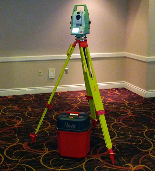
    At a media event held during the HXGN Live Conference in Las Vegas today, Leica Geosystems introduced several new products. The highlight of the event was presentation of Leica Nova and the Leica Nova MS50 MultiStation.

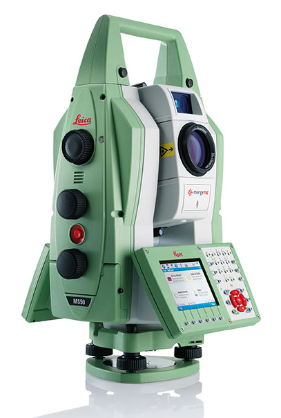
    The Leica Nova measurement solution is designed to provide users with a complete and seamless workflow, Leica Geosystems said. It integrates advanced measurement technology, modern and intuitive field software, intelligent office software, and Leica’s services to give users the ability to make faster, smarter decisions, across a range of applications. The flagship of the new solution is the Leica Nova MS50 MultiStation, which combines scanning, total station, imaging and GNSS positioning in one instrument to deliver fast and reliable results.

    Leica Nova uses advanced measuring technology that provides accuracy and quality, yet is easy to use for an unprecedented range of applications, Leica said. The Leica Nova solution covers the complete process from capturing and visualizing data, to creating intelligent deliverables that shape the world. Whether users measure objects on a construction site, quickly calculate volumes, monitor a dam or a bridge, capture an accident scene with digital imaging or scan a façade, Leica Nova integrates all these capabilities in one compact, flexible solution.

    The Leica Nova MS50 MultiStation. Photo : Leica Nova
    The Leica Nova MS50 MultiStation. Photo : Leica Nova

    The Leica Nova MS50 MultiStation combines every significant measuring technology in one device for the first time, Leica said. Precision 3D scanning, extensive and precise total station capabilities, digital imagery and GNSS connectivity are brought together in the multistation. The new mergeTEC technology fuses hardware capabilities with comprehensive data-management solutions. Images are synchronized with scans, and scans are tied into total station measurements, making it easy to manage complex 3D data, Leica said.

    The Leica Nova MS50 integrates 3D point cloud measurements into regular survey workflows. Users can collect and visualize their topographic survey data with detailed high-precision scans. They save time by computing results and verifying the integrity and completeness of data immediately in the field, avoiding costly reworking or returns. Ultimately, users benefit from better decisions with richer and more detailed data.

    Also part of the innovative new Leica Nova solution are the Leica Nova TS50 high-precision total station and Nova TM50 monitoring station.

    The Leica Nova TS50 high-precision total station has 0.5-inch angular accuracy and an optimum combination of angle and distance measuring. Integrated overview and telescope cameras with fatigue-reducing autofocus document the scene with high-quality photogrammetric images using the latest SmartWorx on-board software.

    The Leica Nova MS50. Photo : Leica Nova
    The Leica Nova MS50. Photo : Leica Nova

    The user sees on the remote control display exactly what the Leica Nova TS50 sees, allowing for easy one-person data capture. The Leica Nova TS50 allows full control through “tap and turn” without the need to go to the instrument and back again. The 20-Hz live video stream can be combined with a graphical overlay for cost-effective recording with immediate clarification of ambiguous situations. Together with the benefits of GNSS connectivity, the Leica Nova TS50 offers complete versatility by delivering reliable results, Leica said.

    For critical monitoring tasks, the new Leica Nova TM50 monitoring station provides the highest angle accuracy and offers short measurement cycles through high speed Piezo drives and a fast, highly accurate EDM. The Leica Nova TM50 includes 0.5″ angular accuracy and can measure up to 3’000 meters, which makes it the ideal sensor for monitoring tasks in mines, landslides, etc. For additional documentation, the monitoring sensor includes an overview camera and a telescope camera with 30x magnification and autofocus. The Leica Nova TM50 meets the challenge of 24-hour-a-day, 7-days-a-week monitoring applications. The Leica Nova TS50/TM50 instruments are IP65 rated and designed to withstand the roughest use in the most severe environments.

    Leica GeoMoS 6.0 enhances conventional monitoring methods with automatic scanning of surfaces with the Leica Nova MS50 MultiStation. Photo : Leica Nova
    Leica GeoMoS 6.0 enhances conventional monitoring methods with automatic scanning of surfaces with the Leica Nova MS50 MultiStation. Photo : Leica Nova

    The Leica software portfolio includes the following:

    • With the new Leica Infinity software, users can seamlessly manage, visualize, process and georeference combined total station, imaging and scanning data from the Leica Nova MS50 MultiStation and other Leica Geosystems sensors.
    • For AutoCAD users who have never before worked with rich point clouds or 3D datasets, the new Leica MultiWorx for AutoCAD plug-in software offers a simple way to integrate point cloud processing into existing workflows.
    • Leica Cyclone and Leica GeoMoS as well as numerous other software packages from partners such as MicroSurvey and Listech can also be integrated into the workflow to meet specific needs.

    Here is a video of the Leica Nova MS50.

  • C-Nav Solutions Offers C-Tides GNSS Tide Measurement Package

    C-Nav, supplier of international GNSS Precise Point Positioning services, has launched its latest GNSS real-time tide measurement package, C-Tides.

    The C-Tides suite combines the vertical accuracy of C-Nav’s GNSS Precise Point Positioning service with the latest advanced ocean and coastal tides models, the company said.

    C-Tides Online features real-time filters and vessel dynamics, a choice of worldwide Mean Sea Surface or regional reference frame models, and tidal prediction for mission planning.

    C-Tides Offline utilities include data smoothing and outlier rejection, harmonic analysis, Doodson X0 filter, and a LAT option.

    “It’s been a privilege working with our academic partners to develop what is probably the worlds’ most advanced real-time GNSS tide solution,” said Russell Morton, C-Nav head of development.

    C-Tides is a fully supported C-Nav utility. The results are suitable for combining with other suitably calibrated vertical components to achieve IHO SP44 Order 1 or better.

  • Hemisphere GNSS Announces High-Precision R330 Universal GNSS Receiver

    R330
    Photo: Hemisphere GNSS

    Hemisphere GNSS has rolled out the R330 GNSS receiver, a versatile, fully featured positioning system. R330 delivers accurate and robust positioning through a variety of differential correction methods including SBAS, L-Band, Beacon and RTK, the company said. With its wide range of functionality and ease of use, the R330 is suitable for a variety of land and marine applications.

    The R330 GNSS receiver combines the functionality and front panel display of all previous R-series products. Customers can start with sub-meter positioning accuracy and upgrade the receiver with subscriptions that add functionality and improves performance capability to centimeter-level accuracy. To provide the most reliable solutions, R330 is capable of tracking multiple frequencies and multiple constellations including GPS and GLONASS. Users can easily switch between the various DGPS correction options without any downtime. The R330 GNSS receiver is compatible with many of the Hemisphere GNSS’ multi-frequency antennas.

    The small, rugged receiver includes a display and status indicators for a user-friendly experience, Hemisphere GNSS said. A standard USB flash drive can be used for data logging.

    “The functionality and performance of the R330 receiver can be custom-fit to positioning applications such as pipeline, marine, and volumetric surveys, GIS mapping, vehicle tracking, machine control, meter monitoring and many others,” said Ron Ramsaran, senior product marketing manager at Hemisphere GNSS. “R330 customers will benefit from the reliability, value, and upgrade options that can be added to meet changing needs.”

    R330 features Hemisphere GNSS’ exclusive Eclipse SureTrack technology, enabling a more robust RTK solution with fewer dropouts in congested environments and a fast reacquisition when dropouts do occur. Long-range RTK baselines of up to 50 km are achievable with R330.

    The R330 GNSS receiver will be available in June through the Hemisphere GNSS Precision Products global dealer network.

  • Surveyors Invited to ‘Survey Earth in a Day’

    sealOn the day of the solstice, June 21, geospatial professionals around the world and members of Land Surveyors United (a global support network for land surveyors) will be simultaneously recording survey grade GPS data from thousands of points around the globe, in order to gain a more accurate understanding of the earth’s surface.

    This will be the second Survey Earth in a Day event; in 2012 the first Survey Earth event was held, establishing many new understandings between geospatial and geomatics professionals and the general public on geospatial issues, organizers said. “With a mission not only to learn more about the Earth’s surface but also monitor its changes over time, and the changes in public perspective, as a global community, we may be more capable of assessing our future,” organizers said.

    “Our results will change the knowledge we currently have of the shape of the earth and thus provide new information about our planet’s surface for the benefit of all man-kind. Help the surveying industry and the surveyors in your region of the world by representing your area as we re-measure the entire globe in one single day,” organizers said.

    “If you are a geospatial professional with access to survey grade GPS equipment, you should consider helping us set a world’s record, right from where you live and work. Only a surveyor can provide the kind of precision that will be needed to truly understand the shape of planet earth. Just imagine how much this can help our industry,” organizers said.

  • NVS Technologies Releases Firmware Update for NV08C Receivers

    NVS Technologies has released updated firmware for its NV08C receiver series. Firmware v0206 is compatible with current and preceding hardware revisions of the NV08C receiver series. Firmware v0206 can be downloaded free of charge.

    Firmware v0206 offers:

    • Stabilized raw data output for output rates up to 10 Hz
    • Extended $POUTC NMEA message, including current LEAP SECONDS value, flags for expected UTC correction, and PPS edge shift relative to UTC (sawtooth correction SW).
    • Stabilized sleep mode operation ($POPWR,1111*66) for all NV08C series HW versions
    • Increased position accuracy and stability in urban canyon conditions with poor SV visibility
    • Cold start initialized to LEAP SECOND 16 (LEAP SECOND 16 came into effect July 1, 2012)

    Benefits include:

    • Obtain initial receiver coordinates more quickly, in cold starts, low satellite signal (foliage/canopy) and loss of satellite signal conditions (indoor, garages, tunnels…).
    • Greater satellite tracking reliability in poor visibility conditions (urban canyon/tall buildings, bridges/underpasses…).
    • Stable raw data output up to 10Hz rate.
    • Full sleep mode support for effective power savings.
    • Complies with ERA-GLONASS requirements.
  • GeoGathering 2013: Have You Developed Your Geospatial Data Strategy?

    GeoGathering logo NO_YEARThe conference GeoGathering: GIS for Gathering and Production Lines will be held Colorado Springs at the Cheyenne Mountain Resort on August 21-22, 2013. With the theme of “Developing a Data Strategy: Data Collection and Sharing,” the conference focuses on how operators collect and share information about their assets to increase operational safety and improve pipeline decision-making.

    “Today, acquisitions and fast growth in the gathering industry are forcing operators to develop a data strategy and look deeper at all aspects of their pipeline asset data – from how it is collected, to making it available to decision makers,” said Victoria Skogman, is the conference manager. “Currently, gathering systems are unregulated, but trends in the industry show this is likely to change in the future. Preparing for this impending change is crucial, hence the theme of the conference.”

    The goal of the GeoGathering Conference is to provide valuable information to gathering system and upstream operators who want to create efficient, accurate, and collaborative data strategies that work for their organizations. Presenters will demonstrate how GIS technology allows attendees to collect and share data between the field and the office, enabling their organization to make well-informed decisions. The versatile agenda focuses on real-world experiences — everything from integrity management and data requirements to data security and making GIS technology more accessible to stakeholders, Skogman said.

    The GeoGathering Conference committee estimates that close to 150 GIS professionals and top-level management from leading oil and gas companies will attend this year. Attendees will be able to attend sessions that include:

    • Developing a Data Strategy
    • Data Collection Methods to Meet Requirements
    • Data Security and the Cloud
    • Data Sharing: GIS as an Enterprise
    • Organizing Data for Decision-Makers
    • PHMSA MAOP Strategies
    • Web-enabled Data Sharing Technologies & Portals
    • Collecting & Sharing Data to Enhance Safety

    This year, attendees will experience the new, audience-focused format that offers two simultaneous tracks giving attendees the chance to tailor their own conference schedule. Plus, two of the biggest improvements are the addition of “structured networking” sessions and a “GIS Think Tank.”

    Structured Networking facilitates a small group setting, in which attendees have the opportunity to meet people with common interests, share practical ideas, and network with individuals who might possibly help your organization. When attendees leave the networking session, they will have a solid list of new business contacts, Skogman said. The networking sessions are strategically placed at the beginning of the conference to help you build new relationships over the duration of the conference.

    The GIS Think Tank session is also a unique addition to the agenda. It will feature five to seven GIS managers from a variety of gathering operators around the country. This is not a typical Q&A panel session; instead, it will allow the participating GIS managers to converse among themselves as the audience listens in. This will be mostly an unstructured session so that managers can spend more or less time on topics as they choose, Skogman said. It will be facilitated with questions from the audience. The purpose is to lead an informal discussion on some of the successes that each manager has had along with their opinions on pressing issues that gathering operators are facing.

    This year’s conference has a seven-person steering committee with pipeline gathering background. Members include Trisha Menasco of DCP Midstream, Tom Coolidge of Esri, Ellen Nodwell of Hess, Cameron Collins of Williams, Rob McElroy of McElroy Consulting, Ron Brush of New Century Software and Victoria Skogman of New Century Software.

    “The conference topics are very timely,” said Menasco. “Just when I thought I had all the data requirements figured out, it feels like we are starting over. I look forward to helping build an agenda that will be useful to the gathering community.”

    Early bird registration is open. The conference committee welcomes senior management, project managers, integrity management specialists, GIS professionals, field operations managers, regulatory compliance personnel, and engineers.

  • Applanix Introduces POSPac MMS v6.2 Software for Mobile Mapping

    Applanix has introduced POSPac MMS v6.2, its latest generation of software for directly georeferencing mobile mapping sensors using GNSS and inertial technology. Featuring new Applanix IN-Fusion Multi-Single-Base Processing, POSPac MMS V6.2 is designed to improve the productivity and accuracy of mapping from mobile platforms in the air, on land or at sea, the company said.

    IN-Fusion Multi-Single-Base Processing is designed for customers who need the highest level of differential GNSS position accuracy and perform long, linear projects such as power-line corridors, long highways or stretches of coastline. During these projects, a GNSS base station network may not be available, or the geometry of the network so weak that an Applanix SmartBase solution — which uses existing reference stations to achieve high accuracy over longer distances — is not viable. In these cases, IN-Fusion Multi-Single-Base Processing allows base stations to be established along the full length of the travel path and makes optimal use of the nearest base station at all times.

    Customers can now take advantage of robust tightly coupled in-fusion processing without the need to break the project up into multiple segments for each base station to attain the highest accuracy, Applanix said.

    “In addition to IN-Fusion Multi-Single-Base Processing, POSPac MMS V6.2 includes new features designed to increase productivity, efficiency and ease-of-use.  The Coordinate Conversion tool included allows users to choose from a number of local reference frames for inputting base station coordinates,” said Edith Roy, Development Manager of POSPac MMS at Applanix.  “POSPac MMS Version 6.2 demonstrates our commitment to providing customers with not only the most advanced software solutions for mobile mapping applications, but also the easiest to use.”

    POSPac MMS V6.2 can be purchased through Applanix’ global sales network. The software is available as an upgrade to all POSPac users currently under a maintenance contract.

  • Riegl and Applanix Take Flight on UAV


    Riegl Laser Measurement Systems and Applanix Corporation announced today that the Applanix AP50 GNSS-inertial sensor system was successfully integrated with Riegl’s VQ-820-GU topo-bathymetric airborne laser scanner on board the Schiebel Camcopter S-100 UAV. The Riegl VQ-820-GU is specifically designed to survey sea beds and the grounds of rivers or lakes, and is well suited for combined land and hydrographic airborne survey.

    ap50
    Applanix AP50 GNSS-inertial system.

    The Applanix AP50 GNSS-inertial system is a GNSS-inertial sensor plus inertial measurement unit (IMU) in a compact form factor. It features a high-performance precision GNSS receiver and the Applanix IN-Fusion GNSS-inertial integration technology running on a powerful, dedicated inertial engine (IE) board.

    On board an unmanned aerial vehicle (UAV), the system is capable of penetrating areas that may be too dangerous for piloted aircraft or ground patrols. This can provide additional safety and security for its users.

    VQ-820-G_206x200px
    Riegl’s VQ-820-G airborne laser scanner.

    “We really appreciate the professional and amicable cooperation with Applanix, which allows us to offer user-friendly and powerful, fully integrated solutions for dynamic data acquisition to the marketplace,” said Jürgen Nussbaum, Riegl director of international sales.

    In addition, Applanix will be a Gold sponsor at Riegl LIDAR 2013, Riegl’s international user conference taking place in Vienna, Austria, June 25-27.

  • Trimble Offers Improved Version of RealWorks Software

    Trimble RealWorks version 8.0 software will include a new 3D database engine, automated targetless registration and Web viewing capability incorporating RealWorks’ Scan Explorer interface. The new version is due to be released in June.

    The new enhancements will allow surveyors, contractors, engineers and geospatial professionals to rapidly process 3D laser scanning data and expedite the creation of deliverables for their clients, increasing productivity and reducing costs, Trimble said.

    The new 3D database engine in Trimble RealWorks version 8.0 will allow up to five times more data to be visualized and managed, compared to Trimble RealWorks version 7.2. The ability to handle larger data sets greatly increases usability and productivity for customers capturing data with 3D laser scanners such as the Trimble TX5 and Trimble FX.

    The automated targetless registration function, together with additional workflow enhancements, will provide further productivity gains for customers. The automated targetless registration function automatically identifies planar objects in each scan and matches the planes from multiple stations, creating a combined data set. The function enhances productivity in the field by eliminating target placement prior to data capture in applicable environments. Office processing time is also reduced by the fully automated function.

    Sharing of data with clients has been enhanced by the addition of a Publisher function within the Trimble RealWorks software that allows projects to be custom packaged for viewing via Microsoft Internet Explorer. The Scan Explorer interface, embedded inside a HTML web page, allows clients to navigate and explore the scan data as well as take measurements and add notes.

    “Software is an integral part of Trimble’s 3D laser scanning solutions and is essential to extract information from 3D data captured in the field,” said Tim Lemmon, marketing director of Trimble. “The new version of Trimble RealWorks software significantly improves our customers’ productivity in processing field data, extracting information and preparing deliverables for their clients.”

    The announcement was made today at SPAR International 2013, the leading conference for 3D data capture, processing and delivery technologies.

  • Comments Sought on Future User Needs for Nationwide DGPS

    The U.S. Department of Transportation’s Research and Innovative Technology Administration (RITA), in partnership with the U.S. Coast Guard, is seeking public comments on  current and future user needs for the Nationwide Differential Global Positioning System (NDGPS).

    The agencies want to know how users use NDGPS, and are seeking ideas for future uses or alternative uses.

    According to the notice in the Federal Register,”The NDGPS was designed to broadcast signals to improve the accuracy and integrity of the Global Positioning System (GPS) derived positions for surface transportation, as well as other civil, commercial, scientific, and homeland security applications. This analysis will be used to support future NDGPS investment decisions by the Department of Homeland Security and the Department of Transportation beyond fiscal year 2016. This notice seeks comments from federal, state, and local agencies, as well as other interested members of the public regarding current and future usage of the NDGPS, the need to retain the NDGPS, the impact if NDGPS signals were not available, alternatives to the NDGPS, and alternative uses for the existing NDGPS infrastructure.”

    NDGPS is a ground-based augmentation system that provides increased accuracy and integrity of GPS information to users on U.S. land and waterways. The system consists of the Maritime Differential GPS System operated by the U.S. Coast Guard and an inland component funded by the Department of Transportation. NDGPS is built to international standards, and similar systems have been implemented by 50 countries around the world. Modernization efforts include the High Accuracy NDGPS (HA-NDGPS) system, currently under development, to enhance the performance and provide 10-15 centimeter accuracy with integrity throughout the coverage area. For more information about NDGPS, visit the following webpages:

    Comments and related material must reach the Docket Management Facility on or before July 15, 2013.

    Comments can be submitted identified by docket number USCG-2013-0054 or RITA-2013-0001 using any one of the following methods:

    1. Federal eRulemaking Portal: http://www.regulations.gov.
    2. Fax: 202-493-2251.
    3. Mail: Docket Management Facility (M-30), U.S. Department of Transportation, West Building Ground Floor, Room W12-140, 1200 New Jersey Avenue SE., Washington, D.C.   20590-0001
    4. Hand delivery: Same as mail address above, between 9 a.m. and 5 p.m., Monday through Friday, except Federal holidays. The telephone number is 202-366-9329.

    All comments received will be posted, without change, to http://www.regulations.gov and will include any personal information provided.

    For more details on submitting comments, see the Federal Register notice.

    More information on the status of the NDGPS can be found on the RITA site and the U.S. Coast Guard site. More information on the HA-NDGPS is at the U.S. Department of Transportation site.

  • Topcon Web Portal Provides Real-Time Job Site Management Tool

    Topcon Positioning Group has launched a new web portal—Sitelink3D.net—designed specifically for general construction and engineering companies.

    In its announcement at the Munich construction trade show Bauma 2013, Topcon focused on the website’s features, which include giving end-users an intuitive way to manage and control every aspect of Topcon 3D machine control systems anywhere in the world.

    The subscription web-based service—accessed via computer, tablet or smartphone—is a user-friendly, real-time visualization and communications tool that allows users to access job site status and create new or update job site parameters, and view movement of machines on the job, Topcon said.

    Features of Sitelink3D include file transfers, messaging, machine tracking, remote support and training, real-time cut/fill mapping, and acquiring and storing real-time survey data.

    “While Sitelink3D is a complete site communications systems providing data control, machine tracking and a reporting system in one solution, Sitelink3D.net gives complete site management power in real time and provides remote information access to and from any piece of enabled equipment regardless of location,” said Richard Jackson, vice president of machine control applications.

    “The web portal provides simple, effective tools for monitoring machine efficiencies and site progress,” Jackson said. Through Sitelink3D.net, “companies can now better manage onsite progress, maintain data integrity, optimize production and minimize downtime. The ability to be able to send and receive job data and make instantaneous decisions or corrections saves time, fuel and money.”

    Most machines currently equipped with a Topcon 3D-MC system can be included in the Sitelink3D network by adding the SL-100 radio modem. New Topcon 3D-MC systems can be ordered with the modem pre-installed. Users of Topcon Pocket3D and 3D Office software can also be included in the Sitelink3D network.

  • Topcon Announces MR-1 Precise Heading Solution

    Topcon Positioning Systems has released the MR-1 Heading System, an OEM GNSS solution for high-performance positioning and heading.

    Using the MR-1 receiver and Topcon’s MG-A8 antenna, the system provides “centimeter-accurate RTK positioning and better than 1/10 of a degree heading accuracy in challenging environments,” said Doug Langen, TPS GNSS product manager. “The rugged MR-1 receiver is water and dustproof and operates at a robust operational temperature range of -40°C to 75°C.”

    When combined with Topcon’s Quartz Lock Loop technology, the MR-1 offers continuous operation during “extreme vibration and shock, typical of intense dynamic environments,” he said.

    The MG-A8 antenna of the MR-1 Heading System is designed for moving platforms and provides multipath rejection. It also offers increased resistance to near-band interference from satellite communications systems commonly found in marine applications.

    Additional information is available at www.topconoemsolutions.com.