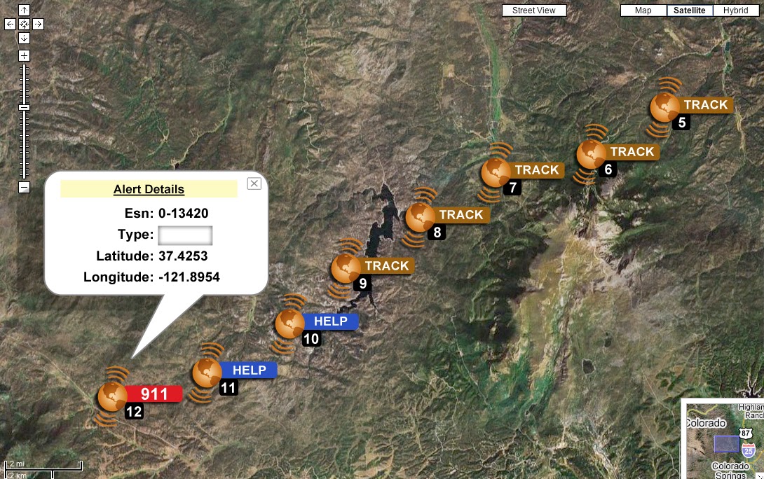
HX Global’s new Travel Oracle mobile app provides an instant lifeline for business travelers and expatriate employees as well as access to critical information and support, before and during their travels, the company said. Key features include an instantly accessible Mayday call, automated personal tracking, online storage of all travel documents, instant news reports of unrest pushed to impacted travelers, e-learning travel security certification and destination profiles.
“Duty of Care requires that measures be taken to protect employees and Travel Oracle accomplishes that,” said Gregory Cain, president of HX Global. “Emergencies can strike at any time. On average, we airlift six medical emergency cases every day and respond to more than 450,000 assistance calls every year. The Travel Oracle app provides a safety net for employees and employers to provide protection for security issues and medical emergencies.”
“Traveler tracking systems have provided travelers and corporations with peace of mind over the years, but they have significant limitations,” said Dave Sarafinas, managing director and senior vice president of HX Global. “Travel Oracle overcomes those limitations by making traveler tracking personal and proactive. This new tool helps corporations provide end-to-end travel security.”
Travel Oracle leverages eLearning, live personal tracking and situational awareness to drive traveler empowerment. Combined with HX Global’s global capabilities and resources in the event of an emergency, a Travel Oracle traveler will be safer, and employers have the confidence that they have exceeded duty of care responsibilities. Key features include:
Emergency Call Function – calls are instantly sent to a 24/7 Command Center
Mayday Alert-Personal Tracking – alerts nominated contacts of traveler whereabouts via email, takes situational photographs, sends an audio recording and current GPS location, if pre-authorized
Online Personal Profile & Documents – online storage of travel documents and photographs
News Alerts and Live Support – global incident monitoring service with real-time country alerts sent directly to employee mobile devices. Access to 24/7 Emergency Assistance Helpdesk
e-Learning – travel safety courses, including certification upon successful completion
Country Profiles – comprehensive country briefings on over 200 countries including country risks and cultural differences
Many of the nation’s leading public safety and public health organizations submitted comments this week in support of a proposed Federal Communications Commission (FCC) rule to help emergency responders more quickly and accurately find 911 callers using wireless phones from indoor locations. More than 300 individuals and organizations filed during the initial comment period with the overwhelming majority supporting the FCC proposal.
Among those supporting the rule were many of the largest and most respected organizations representing 911 professionals, police officers, fire fighters, EMS workers, public safety professionals, older Americans, heart attack and Alzheimer’s patients, and the deaf and hard of hearing. They were joined by hundreds of individual 911 dispatchers and first responders who submitted personal comments through the FCC’s web site or in survey responses that were filed with the FCC.
“The support for this rule across the public safety and public communities is truly breathtaking,” said Jamie Barnett, director of the Find Me 911 Coalition and former chief of the FCC’s Public Safety and Homeland Security Bureau. “These organizations are on the front lines of emergency response, and they know that lives are being lost every day because 911 professionals cannot quickly find indoor callers using wireless phones. The urgency of this rulemaking is unquestionable, and we commend Chairman Wheeler and the other commissioners for their leadership by taking fast action on it.”
According to the FCC’s estimates, at least 10,000 lives a year could be saved by improvements in response time through the FCC’s proposed rule. All of the comments submitted are online.
Find Me 911 is an effort supported by more than 200,000 individuals, as well as national and local organizations. The individuals and organizations represent a broad range of 911 operators and first responders — emergency medical services personnel, fire fighters and police. Find Me 911 seeks to ensure that the FCC moves forward quickly to establish a reasonable, measurable level of location accuracy for emergency calls made indoors, enabling first responders to locate emergency calls from wireless phones from all locations rapidly and efficiently.
Among the organizations filing joint or individual comments in support of the FCC’s proposed rule were:
Law Enforcement
International Association of Chiefs of Police
National Sheriffs’ Association
Fire Fighters
International Association of Fire Fighters
International Association of Fire Chiefs
Emergency Medical Professionals
National Association of State Emergency Medical Services (EMS) Officials
National Association of EMS Physicians
National Association of EMTs
National EMS Management Association
American College of Emergency Physicians
9-1-1 Professionals
National Association of State 911 Administrators
National Emergency Number Association
Association of Public Safety Communications Officials
CALNENA
Texas 9-1-1 Alliance
Texas Commission on State Emergency Communications
[Texas] Municipal Emergency Communication Districts Association
San Francisco Department of Emergency Management
Nebraska Public Safety Commission
Older Americans
AARP
Alliance for Retired Americans
Public Health
Alzheimer’s Association
American Heart Association
Public Safety
National Association of Regulatory Utility Commissioners
National Public Safety Telecommunications Council
Deaf and Hard of Hearing
Telecommunications for the Deaf and Hard of Hearing
National Association of the Deaf
Association of Late-Deafened Adults
Cerebral Palsy and Deaf Organization
California Coalition of Agencies Serving the Deaf and Hard of Hearing
Deaf and Hard of Hearing Consumer Advocacy Network
SPOT LLC, a wholly owned subsidiary of Globalstar, Inc., says its SPOT products have been used to initiate 3,000 rescues around the world since the technology’s launch in 2007. With more than 200,000 SPOT units in service, that averages to one rescue a day. SPOT delivers affordable and reliable satellite-based connectivity and real-time GPS tracking, completely independent of cellular coverage.
“Lifesaving rescues around the globe are now a daily occurrence for our SPOT products. SPOT is an absolute must for the outdoor recreation market and aviation, as well as an essential government and enterprise solution,” said Jay Monroe, CEO and Chairman of Globalstar. “With 3,000 confirmed rescues, saving lives continuously drives us to innovate, creating affordable satellite communications solutions that reach a market well beyond traditional mobile satellite users, including millions of people globally.”
SPOT products allow users to track their assets, use location-based messaging and emergency notification services, and make calls beyond the boundaries of cellular. SPOT products work around the world, including virtually all of the continental United States, Canada, Mexico, Europe and Australia, portions of South America, Northern Africa, North-Eastern Asia and thousands of miles offshore of these areas. Over the past seven years, boaters, hunters, recreational pilots, hikers, off-road travelers and outdoor enthusiasts have come to depend on the lifesaving capabilities of SPOT.
The 3,000th rescue occurred in the Hayman Fire area of Central Colorado. Two dirt bikers were outside of cell range when an accident occurred. One of the riders, Kevin, activated the SOS button on his SPOT Satellite GPS Messenger. The GEOS International Emergency Response Coordination Center was alerted and coordinated the rescue with local law enforcement. “SPOT worked really well. Without it, getting out would have been more difficult and time consuming and who knows what could have happened in that time. There were a lot of different variables involved,” Kevin said.
SPOT products and services include:
SPOT Gen3, a device that provides off-the-grid messaging, emergency alerts, extended battery life, and extreme GPS tracking at 2½-minute intervals.
SPOT Trace, a GPS tracking device that uses satellite technology to track anything, anytime, anywhere.
SPOT Global Phone, a satellite phone that allows users to make calls virtually anywhere beyond the boundaries of cellular.
The SPOT App, a web-based interface allowing users to view their SPOT messages, show their track points, and monitor their assets via smartphone or tablet.
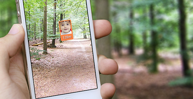
The Trax personal tracker for children and pets uses a u-blox receiver.
Swedish WTS (Wonder Technology Solutions) has launched Trax, a personal tracking device for children and pets. Based on a u-blox GNSS receiver module with integrated antenna and cellular module, the tiny tracker can be located anywhere, anytime via a free Android or iPhone mobile phone app.
In addition to real time tracking, Trax provides flexible geofence alerts, and can monitor how fast your teenager is driving. It also works indoors, thanks to a proprietary dead-reckoning algorithm that delivers a position even when satellites are out of sight. Accurate down to 1.5 meters, the robust, water resistant device also provides an “augmented reality” mode that helps users locate their trackers using a smartphone’s built-in camera view.
To achieve the smallest possible size, Trax uses a u-blox’ CAM-M8Q GNSS receiver module with a built-in antenna. CAM-M8Q (chip antenna module) provides both small size (9.6 x 14.0 x 1.95 mm) and multi-GNSS capability. It is based on a u-blox M8 chip and includes an integrated chip antenna plus SAW filter, LNA, TCXO, RTC crystal and passives. The surface-mount module is also extremely low in height making very thin customer designs possible.
“Trax is the world’s smallest and most versatile personal tracking device available, packed with features designed to provide peace of mind to parents and pet owners almost anywhere in the world,” said Fredrik Danelius, Managing Director at WTS, “By combining the leading GNSS and cellular technologies from u blox, we have designed a tiny, reliable, low-cost device that protects our most valuable family members: children and pets.”
Trax comes with an integrated SIM-card and two years of free data and roaming in 33 countries. It is charged via USB and typically lasts between two and four days on a full battery. For wireless connectivity, device integrates a u blox SARA-G3 GSM/GPRS module which is footprint compatible with the SARA-U2 UMTS/HSPA module for easy 2G to 3G upgrade.
“Trax is an elegant and sophisticated example of our embedded GNSS and cellular modules combined to protect people’s loved ones,” said Pasi Alajoki, Area Sales Manager at u-blox, “It is an extremely important application of our mobile communications and global positioning technology where performance, size and power consumption play a critical role. We are proud WTS chose u-blox for Trax.”
CSR plc and OriginGPS have announced a series of high- performance GNSS modules using CSR’s SiRFstarIV and SiRFstarV product lines.
The new modules are 70% smaller than current solutions and deliver a 30% reduction in Time To First Fix (TTFF), making them ideal for health and fitness trackers, sports watches, medical devices, wearable action cameras, and digital still cameras. All modules, including the newly released 7 x 7 millimeter Multi Spider (ORG4572) solution, integrate the LNA, SAW filter, TCXO, RTC crystal and RF shield.
“To accelerate market adoption of location technologies in wearable devices and cameras, manufacturers must minimize the embedded GNSS module size without compromising on performance, sensitivity, or power consumption,” said Anthony Murray, senior VP, Business Group at CSR. “By leveraging CSR’s industry-leading GNSS solutions and collaborating with OriginGPS on module development, we have achieved this objective.”
The OriginGPS modules offer high sensitivity resulting in shorter autonomous and aided TTFF, better navigation stability, and higher accuracy in harsh environmental conditions. In real-life testing of the module in camera applications, TTFF performance improves by over 30 percent compared to other solutions. The module also delivers TTFF results in less than one minute over 90% of the time (cold starts).
In addition to its small footprint, the GNSS module’s ultra-fast geotagging capability dramatically improves the consumer experience. The GNSS antenna module’s outstanding sensitivity and OriginGPS’ proprietary Noise Free Zone (NFZ) technology for faster position fix and navigation stability provides geo-tagging availability even under challenging satellite signal conditions such as low signal areas, under dense foliage, in urban canyons, and during motion-based activities. Battery life is considerably extended as a result of CSR’s breakthrough low power Push-to-Fix (PtF) technology, which rapidly establishes a valid position fix enabling the module to hibernate for longer periods of time. Push-to-Fix is an intelligent periodic low power mode that adaptively changes power depending on the operating environment and motion conditions. Advanced algorithms and a powerful on-chip DSP processor maintain high accuracy (QoS) while achieving the lowest power level possible for the given environmental and motion conditions.
“As the wearable technology and action camera markets continue to grow, we must ensure that our solution meets the market’s need for high performance and small form factor GNSS modules,” says Gal Jacobi, CEO of OriginGPS. “It is our privilege to partner with CSR and its excellent engineering team to meet the market’s need. CSR’s leading multifunction semiconductor platforms and OriginGPS’ miniaturized high performance modules create a unique value proposition for customers in these markets.”
OriginGPS modules are currently in mass production, and additional information can be found at www.origingps.com.
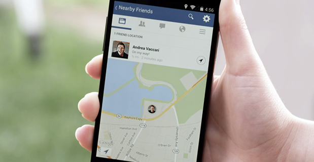
Facebook Nearby Friends feature helps people get together.
Facebook has started rolling out a feature called Nearby Friends. Users can turn on the feature to help them discover which friends are nearby or on the go. When notified that a friend is nearby, the user can then get in touch or meet up.
“For example, when you’re headed to the movies, Nearby Friends will let you know if friends are nearby so you can see the movie together or meet up afterward,” wrote Andrea Vaccari, Facebook Product Manager, in an article on the website.
Nearby Friends is an optional feature. Users can choose who can see whether they are nearby (such as friends, close friends, or a specific friends list) and it can turned on and off at any time. Both the user and the friend needs to have the feature turned on and choose to share that information before notifications are sent.
Users can also choose to share a precise location with particular friends for a set period of time, such as the next hour. The friend will see exactly the user’s location on a map, to help them meet up.
Nearby Friends will be available on Android and iPhone in the U.S. over the coming weeks.
SkyTraq‘s new family of high-performance system-in-package (SiP) GNSS receiver modules supports GPS, GLONASS, Beidou, QZSS and SBAS.The modules integrate SkyTraq Venus8 positioning engine, 1MByte Flash memory, LNA, SAW filter, high precision 0.5ppm TCXO, RTC crystal, and other passive components within tiny 10mm x 10mm x 1.3mm package. The smallest configuration requires only antenna and power to have position fix and generate NMEA output.
This new 10mm x 10m sized GNSS module family consists of Venus858F-GL GPS/GLONASS receiver module, Venus858F-BD GPS/Beidou receiver module, and Venus838F GPS receiver module. All three modules support additional QZSS and SBAS signal. The three modules are pin compatible; one application design works for all three models.
Within the consumer and industrial GNSS segment, these modules feature industry’s fastest 50Hz GPS, 20Hz GPS/Beidou, and 20Hz GPS/GLONASS update rate, 29sec cold start TTFF, and better than -160dBm tracking sensitivity.
Module interface includes two UART, four SPI, one 2-wire interface (I2C compliant), and two PWM among the 28 function-multiplexed digital I/O. A customized Arduino IDE can be used to program the modules, making use of the on-chip peripherals and sharing the internal 32bit RISC, IEEE-754 compliant FPU, and memory resources. Venus838F GPS module has roughly 50MIPS + 490KByte Flash + 45KByte RAM available for user programming.
Optimized for lowest bill of material cost, the dime-sized modules are designed for high-volume cost-sensitive GNSS applications. Combined with properly tuned antenna fitted to customer’s application design, it provides optimal performance at lowest system cost.
To lower barrier of adopting latest satellite navigation technology, the traditionally higher-priced GPS/GLONASS and GPS/Beidou receiver modules are offered at same price as the GPS receiver module.
Volume delivery of all three modules to customers begins in May 2014; engineering sample, datasheet, reference design, and evaluation kits are available now.
Swedish WTS (Wonder Technology Solutions) and u-blox have announced that WTS has launched Trax, a personal tracking device for children and pets. Based on u-blox’ GNSS smart antenna and cellular module, the tiny tracker can be located anywhere, anytime via a free Android or iPhone mobile phone app.
In addition to real time tracking, Trax provides flexible geofence alerts, and can even monitor how fast your teenager is driving. It also works indoors thanks to a proprietary dead reckoning algorithm that delivers a position even when satellites are out of sight. Accurate down to 1.5 meters, the robust, water-resistant device also provides an “augmented reality” mode that helps users locate their trackers using a Smartphone’s built-in camera view.
To achieve the smallest possible size, Trax takes advantage of u-blox’ CAM-M8Q GNSS receiver module, which has a built-in antenna. CAM-M8Q (chip antenna module) provides both small size (9.6 x 14.0 x 1.95 mm) and multi-GNSS capability. It is based on a u-blox M8 chip and incorporates a chip antenna, SAW filter, LNA, TCXO and RTC crystal. The surface-mount module is also extremely low in height, making thin customer designs possible.
“Trax is the world’s smallest and most versatile personal tracking device available, packed with features designed to provide peace of mind to parents and pet owners almost anywhere in the world,” said Fredrik Danelius, managing director at WTS. “By combining the leading GNSS and cellular technologies from u‑blox, we have designed a tiny, reliable, low-cost device that protects our most valuable family members: children and pets.”
Trax comes with an integrated SIM-card and two years of free data and roaming in 33 countries. It is charged via USB and typically lasts between two and four days on a full battery. For wireless connectivity, the device contains u‑blox’ SARA-G3 GSM/GPRS module which is footprint compatible with u-blox’ 3G SARA-U2 module for easy 2G to 3G upgrade.
“Trax is an elegant and sophisticated example of our embedded GNSS and cellular modules combined to protect people’s loved ones”, said Pasi Alajoki, area sales manager at u-blox. “It is an important application of our mobile communications and global positioning technology where performance, size and power consumption play a critical role. We are proud WTS chose u-blox for Trax.”
When one talks about the worldwide location industry, mobile resource management — fleets and trucks, for instance — aren’t sexy at all, but they make money. What is supposed to be sexy is location-based advertising. According to many analysts, location-based advertising has been hampered by a few things: education for both consumers and mobile advertisers, privacy issues, and relevant proximity information so folks can use it to make purchases. Another concern could be the expense of rolling out indoor beacons.
BARCELONA—Major consumer privacy concerns aside, companies are starting to see growth in location-based advertising, with new markets emerging in Europe. While the numbers of mobile advertising companies has decreased at the Mobile World Congress, held here in February, from just two years ago, the remaining players are seeing a more mature market.
Mobile advertisers are beginning to realize that location is the Holy Grail for growth, said Cameron Peeples, Airpush vice president of marketing. “People going into New York from Newark during rush hour can receive a different call to action because of a created geo-fence. Advertisers can determine whether the traveler is there on business or looking for a hotel and other travel deals,” he said.
Before Mobile World Congress, Los Angeles-based Airpush partnered with AirX, a large mobile ad exchange company. The majority of the AirX inventory, about 120,000 Android applications, includes highly-sought-after GPS location data, the company said.
There are large differences between the North American and European markets for mobile advertising, Peeples said. “The mobile advertising market [in Europe] is definitely evolving. The European market is key for us, dramatically higher than other markets,” he said. “[The European] market seems to have people connected to a lot of things — they are more mobile, use public transportation more, and always have a phone that is more centric to who they are.”
Making location-based advertising relevant to the consumer is still a major challenge. “Our focus next year is on native advertising. Native advertising combines not only the right message, but the right delivery vehicle,” Peeples said. “No one bicycling enthusiast wants ads tailored for someone who wants flowers.”
Peeples said the privacy issues are a big deal, but his company’s services are opt-in. “A lot of it is loyalty advertising. It’s all opt-in,” he said.
xAd Partners with Waze, Sees UK Growth
Another mobile advertising company, New York-based xAd, is also making inroads in Europe. “We are in the UK right now, which is really WiFi-focused. A lot of our early [location-based] advertising efforts are in education — to educate consumers and the advertising agencies about the power of location and mobile,” said Monica Ho, xAd vice president of marketing. “Not all location is created equal. The real value of [location-based advertising] is the proximity target to market to.”
Right before Mobile World Congress, Waze selected xAd as its third-party provider of search and display mobile ads in the United States. Waze, which was bought by Google in a deal worth more than $1 billion, is a top three map and navigation app in the iTunes store — a ranking that was probably helped by the Apple Maps debacle in 2012.
The companies say the deal will place xAd’s mobile ad targeting technologies into Waze’s location-based advertising platform.
Ho said there are still two areas of concern for location-based advertising: relevancy to the consumer and privacy issues. “There was privacy backlash from Nordstrom collecting consumer information from their Wi-Fi system,” she said, referring to the controversy last year when the retailer was accused of capturing consumer information during an indoor positioning test.
Apple to Roll out Upgraded Maps on iPhone 6
Speaking about Apple Maps, many industry analysts says the company has come a long way since the very public embarrassment nearly two years ago over map inaccuracies and flaws. The company recently released iOS 7.1, but is expected to rollout iOS 8 when the iPhone 6 debuts later this year.
With the debut of the iPhone 6, an updated version of Apple Maps will also be released, according to published reports.
Last year, Apple bought two companies, HopStop and Locationary, to allow the company to entrench itself once more in the location business. How firmly those roots prove to be, and how well they serve the company against archrival Google, remain to be seen.
Apple has been stockpiling companies and mapping software since its introduction of Apple Maps on iOS devices, which had a rough start. GPS World’s LBS Insiderreported extensively on the problems Apple encountered with its mapping software. Some of these problems included sending drivers to a wrong location and direction.
After the mapping software problems were made public, Apple CEO Tim Cook apologized for the mapping software’s problems and even suggested that users go to such competitors as Waze, MapQuest, and Microsoft’s Bing.
In other location news:
A Wall Street Journal reporter basically said there was nothing much new at Mobile World Congress — and that the excitement and action was at the outlying conferences at Fira Montjuic. One of these more interesting conferences, Four Years From Now, or 4YFN, featured start-up companies making pitches and displaying their new products, some of which included location capability.
The Mobile World Congress final stats. Organizers said MWC had more than 85,000 attendees from 200 countries — an increase of 13,000 from the previous year. It’s now being touted as the biggest and best wireless show.
In February, GPS World reported that TruePosition had purchased Skyhook for an undisclosed price. Skyhook provided location services to a number of companies including Apple and Samsung. The interesting issue is Skyhook’s lawsuit with Google, which alleged that the Internet giant influenced smartphone manufacturers to abandon the Boston-based company. According to published reports, the legal action still is going forward.
AT&T Mobility is shuttering its location-based Alerts marketing program. The company said it would release an updated version later this year. AT&T Mobility launched Alerts in late 2012. It featured free opt-in, location-based text message alert service. Participating retailers included Stapes, Gap, Zales, Neiman Marcus, and others.
I didn’t go to South by Southwest. Is my cool-guy card revoked? One of the reasons I didn’t is because, outside of meetings that were not part of the conference, there was not one location industry announcement made there. Maybe something will change my mind next year, but call me an old fogey — I just didn’t see the need to go to Austin this year.
Harris Corporation has achieved a key milestone under a five-year contract with Aireon LLC that will create the first global satellite-based aircraft tracking system. The announcement was made during the SATELLITE 2014 Conference and Exhibition, held March 10-13 at the Washington Convention Center in Washington, D.C.
The company’s Automatic Dependent Surveillance-Broadcast (ADS-B) 1090 Extended Squitter receiver payload has been successfully tested and qualified for simulated operation in the harsh environment of space for more than 12 years. Simulated performance testing also validated the agility of the payload to adapt to evolving aircraft traffic patterns over the same span of time.
Harris is providing Aireon with 81 of the ADS-B receiver payloads. They will be hosted on board the Iridium NEXT satellite constellation to enable precise aircraft tracking that will optimize air traffic management around the world. Ground-based ADS-B networks, which process GPS signals and other data from aircraft, are limited by an infrastructure that cannot monitor flights over oceans or remote regions, a limitation now highlighted by the disappearance of a Malaysia Airlines jetliner on March 8.
The Harris payloads are based on the company’s AppStar reconfigurable payload platform. They will be mounted on 66 low Earth-orbiting satellites, six on-orbit spares and nine ground spares that comprise the Iridium NEXT constellation. The air traffic surveillance function will be performed separately from the main mission of the spacecraft. The constellation’s main mission is providing voice and data coverage to satellite phones, pagers and integrated transceivers over Earth’s entire surface. The launch of the first Iridium NEXT satellite is planned for 2015.
“Completion of this testing verifies that our payload design works for its intended environment and moves us into the production phase,” said Bill Gattle, vice president and general manager, National Programs, Harris Government Communications Systems. “This program exemplifies the benefits of a public-private partnership model, using commercially hosted payloads to get both government and commercial mission capabilities into space without the time and cost required to build and launch separate satellites.”
“Harris has met or exceeded all of the major milestones in the development and test of the receiver payload for this groundbreaking program,” said Don Thoma, president and CEO, Aireon. “The combined, powerful offering our collective organizations will provide to the global air traffic community will transform air travel.”
Three additional companies — Qualcomm, Red Bend and QuickPlay — have signed on to work with the connected car industry at the AT&T Drive Studio, a connected car center for innovation and research in Atlanta, Georgia.
“This is an exciting ecosystem and we are committed to leading the way to take the connected car to the next level for auto manufacturers and their drivers,” said Glenn Lurie, president, AT&T Emerging Enterprises and Partnerships, AT&T Mobility. “That’s the essence of the AT&T Drive Studio, to bring together the best players in the auto industry ecosystem to collaborate and create the future faster.”
The AT&T Drive Studio will now include support from the following companies:
Qualcomm Technologies, Inc., intends to showcase its newly announced Qualcomm Snapdragon Automotive Solutions for infotainment and telematics at the AT&T Drive Studio. Qualcomm Technologies plans to integrate these solutions with AT&T’s Drive portfolio, including AT&T’s global SIM, bifurcated billing, voice recognition, and the nation’s most reliable 4G LTE network.
AT&T has selected Red Bend Software to be a solution provider to remotely manage automotive software in the new AT&T Drive Studio. Hosted in the AT&T cloud, the Red Bend Software Management Center is an OMA-DM standard-based platform designed for car manufacturers to manage in-vehicle software and applications over the air with reliability and efficiency. Red Bend’s comprehensive software management platform significantly reduces the time and cost for automotive OEMs to manage the lifecycle of all in-vehicle software, from head units to map content and ECUs.
AT&T has selected QuickPlay Media to develop an in-vehicle video service. The offering will be powered by QuickPlay’s OpenVideo platform and will deliver Live Linear TV and streaming video on demand services to automotive manufacturers collaborating in the AT&T Drive Studio. QuickPlay’s solution will enable AT&T to provide in-car “infotainment” by delivering secure streaming of hundreds of live linear TV channels and hours of premium VoD content. The solution includes a configurable, customizable client application, support for adaptive streaming, complete content protection with DRM solutions like Microsoft PlayReady, user entitlements, dynamic advertising, banner ad support, multi-language support and featured content.
Opened in January 2014, the AT&T Drive Studio is a dedicated facility for connected car innovation and research. Located in Atlanta, the more than 5,000-square foot AT&T Drive Studio features working garage bays, a speech lab, and a full showroom to exhibit the latest innovations. The AT&T Drive Studio integrates AT&T solutions across multiple companies and serves as a hub where AT&T can respond to needs of automotive manufacturers and the auto ecosystem at large.
SGP Technologies, a joint venture of Silent Circle and Geeksphone, has unveiled the Blackphone, a smartphone that places privacy and control directly in the hands of its users. The smartphone was launched at Mobile World Congress being held this week in Barcelona.
Blackphone includes a unique combination of operating system and application tools that offer unparalleled security and privacy to information workers, executives, public figures, and anyone else seeking privacy, the company said. Blackphone’s PrivatOS, built on Android and combined with a full suite of privacy-enabled applications, “allows users to regain control over their communications activities. No longer will the use of a smartphone demand acceptance of unauthorized surveillance, commercial exploitation of activity data, and the loss of privacy, security and fundamental human rights,” the company said in a press release.
Blackphone is powered by a >2 GHz quad-core SoC and features a full set of premium features, including GPS, a 4.7-inch HD IPS screen, LTE, HSPA+, 2GB DDR3 RAM, 16GB of storage, >8MP primary camera with flash and 1.3MP front camera, Bluetooth 4.0, and 802.11n WiFi.
Blackphone comes unlocked and features several pre-installed privacy tools, including the Silent Circle suite of apps (Silent Phone, Silent Text, and Silent Contacts); anonymous search, private browsing, and VPN from Disconnect; and secure cloud file storage from SpiderOak. In addition, Blackphone ships with the Smart WiFi Manager from Mike Kershaw, Chief Architect for SGP Technologies, and a powerful remote-wipe and device recovery tool.
Blackphone is available for pre-order to individuals and enterprises as an unlocked device with a starting price of US$629, and will also be available through selected partner carriers from launch, including KPN Mobile, the inaugural launch carrier for Blackphone serving European regions including Belgium, the Netherlands, and Germany. Customers will always have the option of buying direct rather than through a carrier if that is their preference.
Blackphone is scheduled to ship to the first end users in June 2014, and testing units will be provided to partner carriers in the April timeframe.