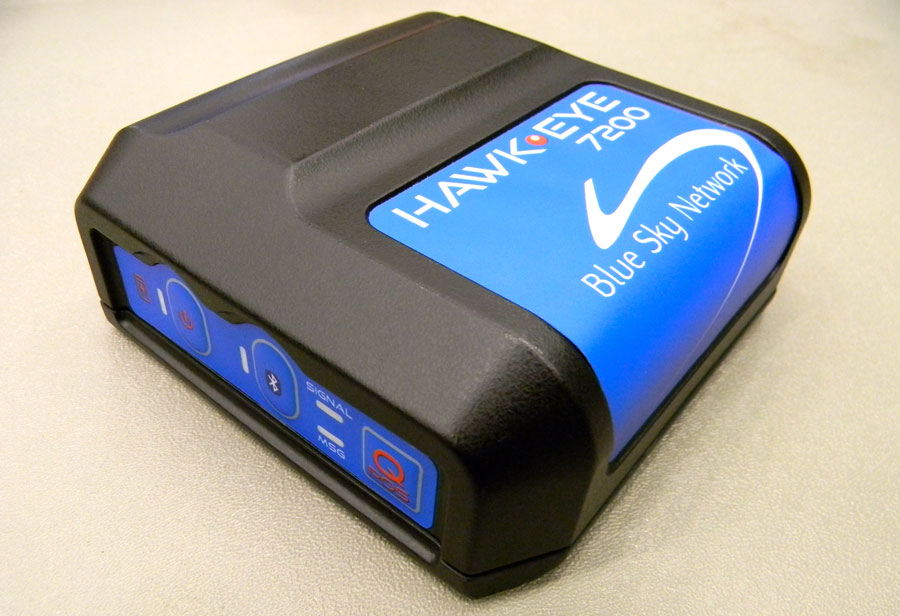
Blue Sky Network’s HawkEye 7200 Portable Tracking Solution.
Blue Sky Network has released the portable HawkEye 7200 with geofencing. The Hawkeye 7200, released in September 2013, is a small mobile device designed specifically for Iridium and GNSS satellite tracking of aviation, land/mobile or marine assets. The company will demonstrate its new AVR (advanced variable response) geofencing capabilities at the upcoming HAI Heli-Expo tradeshow in Anaheim, California, February 25-26.
“Advanced variable response or AVR delivers functionality and utility one level beyond traditional geofencing alarms or alerts. It allows the asset manager or geofence designer to set a conditional response for what happens or does not happen when an aircraft, vehicle, or vessel is in, or out of a geofenced area,” explains John Peterson, Blue Sky Network’s vice president of Business Development. “For example, position reporting frequencies could be turned off when an asset is at its home base, resume normal reporting after leaving the base, and increase reporting frequency when entering regions considered more dangerous. AVR gives asset managers more control, ultimately making fleet management easier, safer, and less expensive.”
In addition to AVR, the HawkEye 7200 offers three significant advantages over traditional satcom asset tracking devices
An all-in-one design including internal long-lasting lithium ion battery and dual Iridium and GNSS antenna;
true concurrent multi-national GNSS for faster, more accurate positioning; and
Bluetooth connectivity using Blue Sky Network’s custom APP for iPhone and iPad, facilitating easy messaging and custom form transmission from Apple devices.
The HawkEye 7200 portable satcom solution works directly with Blue Sky Network’s cloud-based web portal SkyRouter. Skyrouter is a secure online website that provides tracking and management of globally dispersed assets.
Broadcom Corporation today introduced a GNSS system-on-chip (SoC) that will enable wearable location devices to operate with less power and more accuracy, Broadcom said. The Broadcom BCM4771 GNSS SoC is designed for low-power, mass-market wearable devices such as fitness trackers and smart watches. Broadcom will showcase its mobile innovations at Mobile World Congress in Barcelona, February 24-27.
The Broadcom BCM4771 GNSS SoC with on-chip sensor hub enables consumers to more accurately track and manage their health and well-being by delivering precision activity tracking and location data while consuming less power than traditional architectures. This enables location intelligence and the extended battery life needed by the growing wearable market.
Wearable wireless device revenues are projected to exceed $6 billion in 2018 with sports, fitness and wellness as the largest segment with 50 percent share of all device shipments1.
“Today’s wearables like fitness trackers have surged in popularity, but often miscalculate speed and distance,” said Mohamed Awad, Broadcom director of the Marketing, Mobile and Wireless Group. “As the largest supplier of discrete GNSS solutions, Broadcom brings its location expertise to deliver more precise fitness and health measurements to the accelerating wearable market.”
Broadcom’s new chip constantly monitors user activity levels and location history to improve accuracy while adding advanced features such as location batching. In addition, Broadcom’s BCM4771 significantly reduces power consumption and board area by combining its location capabilities with an integrated sensor hub, contextual awareness, and GNSS. The SoC is complimented by Broadcom’s Wireless Internet Connectivity for Embedded Devices (WICED) Smart and WICED Direct software development kits (SDKs) to provide additional wireless connectivity to the platform.
Key Features. Designed in 40 nanometer (nm) process technology, the BCM4771 GNSS SoC includes a sensor hub that integrates sensor inputs for its on-chip algorithms to detect the user’s context, accurately compute speed and distance traveled, and provide fitness applications with the GNSS track. Power savings and advanced accuracy are achieved by intelligently leveraging context detection through the tight coupling of sensor inputs and GNSS on a single SoC. Broadcom’s BCM4771 also realizes a lower overall bill of materials (BOM) cost through the integration of a multipurpose sensor hub, the company said.
The BCM4771 will be sampling by the end of Q1 2014.
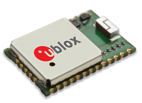
u‑blox has introduced the CAM-M8Q GPS/GLONASS/BeiDou/QZSS antenna module. The module integrates a u-blox M8 satellite receiver IC plus SAW filter, LNA, TCXO, RTC, passives and a pre-tuned GNSS chip antenna in an ultra-small 9.6 x 14.0 x 1.95 mm package. The new module requires only a power source for reliable and accurate satellite positioning anywhere in the world.
Combining low power consumption with high-sensitivity, high jamming immunity and concurrent GNSS operation (GPS/GLONASS, GPS/BeiDou, or GLONASS/BeiDou) the surface-mount CAM-M8Q provides a drop-in solution for satellite positioning in an ultra-small form factor, u-blox said.
“Our u-blox CAM-M8Q is perfect for customers designing highly compact products who want to speed up product development while freeing resources for core activities,” explains Thomas Nigg, vice president of product marketing at u-blox. “The CAM-M8Q is a pre-tuned, performance and cost optimized module providing satellite positioning on an extremely small footprint. It is literally an ‘instant’ positioning solution.”
The u-blox CAM-M8Q module is designed for a wide range of applications such as personal locators, handheld navigators, and wearable electronics as well as vehicle telematics systems used for emergency call, anti-theft, insurance and road pricing. Consistent omni-directional antenna performance helps ensure excellent performance regardless of module orientation.
In addition, the CAM-M8Q allows the internal chip antenna to be used as a backup antenna if the design incorporates an external antenna. This benefits companies where there is a risk that the primary external antenna may malfunction or suffer damage, for example in vehicle tracking systems where damage is possible to the external antenna.
The CAM-M8Q module uses the latest u-blox M8 GNSS receiver chip qualified according to AEC-Q100 and is manufactured in ISO/TS 16949 certified sites. Qualification tests are performed as stipulated in the ISO16750 standard: “Road vehicles – Environmental conditions and testing for electrical and electronic equipment.”
The CAM‑M8Q is form-factor compatible to predecessor modules UC530 and UC530M, allowing the upgrade of existing designs with minimal effort.
Boatracs, Kannad, McMurdo and TSi have combined to form McMurdo Group, a single-vendor provider of end-to-end search and rescue, maritime domain awareness solutions.
McMurdo Group has announced a suite of Automatic Identification System (AIS) survival solutions for enhanced collision avoidance and man overboard (MOB) response in the U.S. recreational boating market. The offerings include AIS beacons, transponders, receivers and software.
AIS is an automatic tracking system used on boats and ships that identifies and tracks nearby AIS-equipped vessels and devices to help avoid collisions. AIS transponders send and receive critical navigation information – such as vessel identification numbers, vessel type, position, course and speed – and graphically display a map of the surrounding vessels and area. AIS receivers are often used in conjunction with AIS-capable computer software for similar tracking and monitoring purposes.
In the event a person with an AIS MOB beacon falls overboard, an AIS signal from the beacon is activated. This signal is then sent to AIS receiving devices where the location of the individual in the water can be pinpointed using GPS positioning and presented on graphical chart maps.
The Smartfind M5 has an on-screen beacon location indicator and audible alarm that is triggered to accelerate rescue efforts. It also has a “buddy list” feature that can identify the specific individual needing MOB assistance. For larger fleets, the McMurdo Group AIS Alarm Notification System extends graphical mapping, alarm notification and messaging capabilities to shoreside fleet management operators.
The McMurdo Group AIS product suite includes the following:
AIS Search and Rescue Transponders (SART) or Beacons
Smartfind S5 – a compact, lightweight, waterproof (to 10 meters) AIS SART with high-visibility buoyant carry-off bag ideal for use on life rafts or survival crafts.
Smartfind S10 – a personal, waterproof (to 60 meters) AIS Man Overboard (MOB) device with built-in flashing light and used by individuals or as an additional device to complement a yacht’s on-board flare pack.
Smartfind S20 – a compact AIS MOB device with integrated light for use in a lifejacket.
AIS Transponders and Receivers
Smartfind M5 AIS Class A Transponder – the industry’s first AIS Class A transponder with color display and AIS MOB and AIS SART alarm with crew list functionality to aid in MOB recovery.
Smartfind M10 AIS Class B Transponder – typically used for smaller vessels, charter boat operators or where the additional features of an AIS Class A transponder are not required (includes an a 30 day data logger).
Smartfind M15 AIS Receiver – economical AIS receiver for all recreational vessels.
AIS Software
PC Viewer – Graphical software package ideal for individual vessel operators (included with the Smartfind M5, M10 and Smartfind M15 products).
AIS Alarm Notification System – Vessel Monitoring System with integrated AIS MOB Alerts and Messaging typically used for ship-to-shore communications.
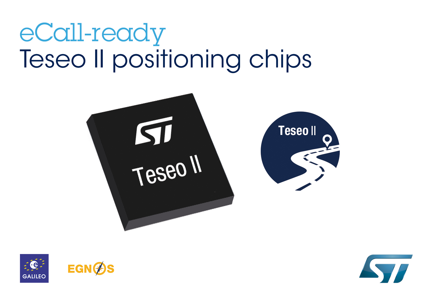
The Teseo II chip is ready for eCall, a European initiative intended to bring rapid assistance to motorists involved in a collision anywhere in the European Union.
STMicroelectronics, a global semiconductor company, has released its Teseo II single-chip satellite-tracking integrated circuit to the European Space Agency (ESA) and the European Commission Joint Research Center (JRC) for testing for eCall approval. The testing campaign is coordinated by the European GNSS Agency as part of its effort to accelerate Galileo adoption.
The Galileo tests will be conducted by the ESA and JRC over the next months to validate ST’s latest firmware release, according to the European GNSS Agency (GSA) test plan. The testing campaign supports the upcoming Galileo early operational services that are expected to go live at the end of 2014. In addition, the tests will evaluate Teseo II compatibility with the European Geostationary Navigation Overlay Service (EGNOS) and with Galileo for the eCall in-vehicle system that automatically sends notification messages from vehicles involved in an accident. Beside static and dynamic test conditions, the testing plan foresees three different use cases, in systems for single-, dual-, and up to triple-constellation (GPS/Galileo/GLONASS) systems.
Following the first position fix using Galileo in-orbit validation satellites conducted by ST and ESA in March 2013, STMicroelectronics has implemented the Galileo Golden-candidate production firmware as an additional constellation in its Teseo II chips. While the Teseo II ICs have always had the capability to be Galileo-ready, ST is enabling a firmware update from the Galileo navigation system. This update benefits consumers and doesn’t require any hardware modification.
The Teseo II chips can simultaneously use signals from multiple satellite navigation systems, including the currently available Galileo satellites, and progressively, as future satellites are launched, the full satellite constellation.
ST’s leadership in the multi-constellation reception delivers immediate use of the Galileo satellites already in orbit, and provides consumers with shorter time-to-first-fix, continuous tracking with enhanced accuracy, and effective operation under challenging circumstances, such as driving through urban canyons.
In January, GPS Worldpublished a cover story on the next-generation Teseo-3 chip, which also provides background on the development of the Teseo II.
Introduced in January 2011, ST’s Teseo II is a standalone satellite receiver able to use signals from multiple satellite navigation systems, including GPS, the European Galileo system, Russian GLONASS, and Japanese QZSS. This multi-constellation approach keeps many satellites in sight, delivering advantages such as shorter time-to-first-fix and continuous tracking with enhanced accuracy, even under challenging circumstances such as driving through urban canyons.
The Sochi 2014 Olympic Winter Games mobile app, Wireless Olympic Works (WOW), turns the world’s Android devices into mobile sports stations that fans can use to personalize their own Olympic Winter Games experience, according to maker Samsung Electronics.
The XXII Olympic Winter Games, held in Sochi, Russia, run February 7-21.
Fans attending the Olympic Winter Games in Sochi will have access to a location-based Olympic Winter Games venue guide through the Samsung WOW technology. The guide offers Olympic venue information and navigation services so visitors can feel truly integrated into the Olympic Winter Games experience on the ground, Samsung said.
Samsung’s Public WOW app also provides sports fans with real-time access to event schedules, latest reports on results, medal standings and Olympic records. Public WOW is an extension of Samsung’s custom WOW for the Olympic Family, which is a wireless communications platform developed to ensure smarter communications and smoother, wireless operations of the Olympic Winter Games by offering news and information about the games to officials and staffs.
“Samsung is offering fans around the world the most direct access to Sochi 2014 Olympic Winter Games and allowing them to design and personalize their experience in ways that are most relevant to their interests and passions,” said WS Lee, senior vice president of New Business Development, Mobile Communications Division at Samsung Electronics. “Our dedicated teams are hard at work year-round to ensure that the WOW technology is ready for use throughout the Games, both for consumers looking for the ultimate Olympic Winter Games experience, and for the Olympic Family utilizing our technology to support Games-time operations.”
All Android users worldwide can download Samsung’s Public WOW app via the Samsung App store and Google Play.
Components of the Samsung WOW app allow fans to design their own Olympic Winter Games experience in the following ways:
Personalize an Olympic Winter Games updates plan. highly personalized, live Games-time updates ranging from medal counts to big moments that can be pushed to users’ phones in real time. A new cheering service will allow fans to send cheers to support their favorite athletes and countries.
Share celebrations with social network features. Users can upload text and images instantly to share with other WOW app users and with their social networks, creating a global community around shared interests in the Olympic Winter Games and winter sports. Languages supported for the Public WOW app include Chinese, English, French, German, Korean, Russian and Spanish.
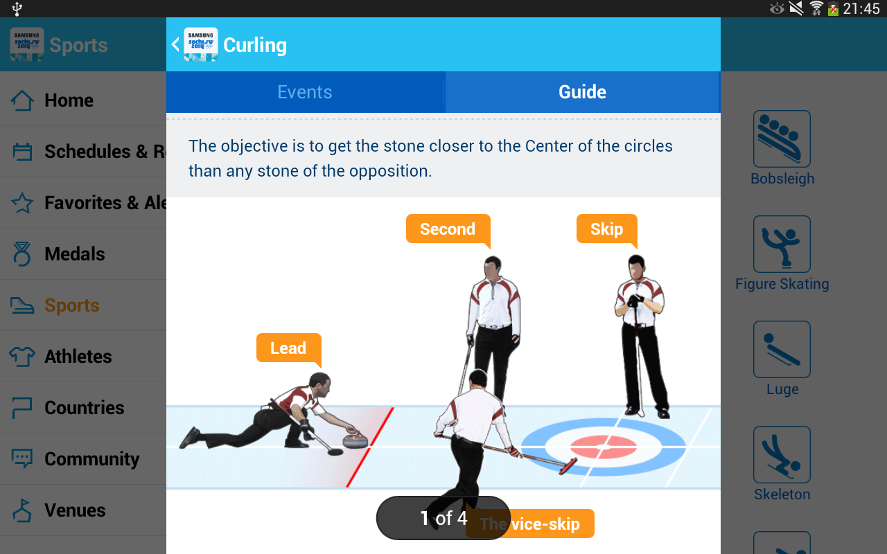
Learn about Olympic sports with an interactive, visual guide. The app offers information on all 15 winter sports at Sochi 2014 through a highly visual and engaging graphic user interface. A Visual Sports Guide will provide tutorials on each sport, including rules, equipment details and many other points of interest bring people closer to the excitement of the Olympic Winter Games.
“With its advanced technology in wireless communications, Samsung has played an essential role in the successful operation of the Olympic Winter Games. We believe the WOW app for Sochi 2014 will once again benefit the Games with more efficient and faster communications for the Olympic Family as well as fans around the world” said Timo Lumme, managing director, IOC TMS.
As part of the “Samsung Smart Olympic Games Initiative,” Samsung will provide around 18,000 mobile devices to the Olympic Family, including executives, staff, and officials from the IOC, National Olympic Committees and organizing committees in Sochi. They will be connected to Samsung’s WOW service which will provide essential, up-to-date Games Time data and connectivity that is crucial to the Olympic Winter Games operation.
The Samsung WOW service was first launched during the Athens 2004 Olympic Games for the Olympic Family and has since evolved into a must-have resource for officials, attendees and fans worldwide.
Samsung began its Olympic Games involvement as a local sponsor of the Seoul 1988 Olympic Games. Beginning with the Nagano 1998 Olympic Winter Games, the company extended its commitment to the Olympic Movement as the Worldwide Olympic Partner in the Wireless Communications Equipment category, providing its proprietary wireless communications platform, called Wireless Olympic Works (WOW), and mobile phones. These mobile phone technologies provide the Olympic Family with real-time, user location-based information service and interactive communications. Samsung’s commitment as a Worldwide Olympic Partner continues through to Rio 2016.
Despite major GPS fitness device OEMs announcing new fitness products at January’s International Consumer Electronics Show in Las Vegas, it looks like an increasingly difficult battle between smart devices and wearables, according to analysts at ABI Research.
Garmin launched its Vivofit fitness band and Vivoki/Vivahub corporate wellness solution. Magallen is one of the few companies in the GPS device OEM space that continues to show flashes of innovation, opening up its Echo watch platform to a range of third-party smartphone application developers.
At the high-end of the GPS fitness watch market, Polar has launched a new multi-sport watch, which features a barometric pressure sensor, support for new features such as a cycling power pedal. TomTom has launched an iOS application that links its current GPS watch range to an iPhone via Bluetooth.
In ABI Research’s quarterly GPS/GNSS Device tracker, the impact of these new device categories on dedicated GPS fitness device growth can be fully seen. Senior analyst Patrick Connolly comments, “Our forecasts for the overall GPS-enabled fitness area remain strong, hitting $2.6 Billion in 2018, but as was the case with turn-by-turn navigation, converged devices and wearables will take an increasing part of the available market. The adage of keeping what we have is important here, retaining a firm eye on growth in professional users, with hardware and in particular eyewear, a major distinguisher.”
Practice director Dominique Bonte adds, “Of the announcements, Garmin’s move into corporate wellness was the most striking. We are about to see a huge technological shift in the corporate/business sector, around BYOD, BYOW, wellness, security, and efficiency. What is interesting is that Garmin does not include a location element, which will be a core enabler in this sea change.”
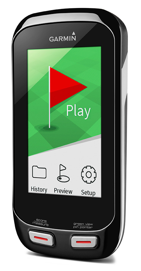
Garmin International has introduced two new handhelds geared for the golf aficionado, including a new top-of-the-line model, the Approach G8.
The Approach G7 and G8 golf handhelds have color touchscreens, more than 30,000 preloaded international courses, a rechargeable battery capable of multiple rounds, and new measurement features such as PlaysLike Distance, which shows adjusted range for uphill and downhill shots.
For golfers who prefer to leave their smartphones in their bags, the new Approach handhelds offer Smart Notification technology, which lets the user pair a compatible iPhone 4S or later to receive emails, texts, and call alerts on the device (Android compatibility is expected in the second quarter of this year). The devices are also compatible with Garmin Connect, so users can upload their scores and track their progress over time.
Both the Approach G7 and G8 incorporate the new measurement feature PlaysLike Distance, which adjusts distances for uphill and downhill shots, so players get the most accurate yardage measurements. Both devices also offer Club Advice, which remembers how far users hit each club and makes recommendations based on shot distances.
Another new feature in the G7 and G8 golf handhelds is the Big Numbers mode, so users can easily see the vital information they need without squinting or reading glasses.
The Approach G7 and G8 handhelds come preloaded with more than 30,000 international courses, with no extra subscriptions or fees. Both devices give precise distance to the front, back and center of the green, as well as layup and dogleg distances. Both devices have a rechargeable battery that plays an entire weekend of golf (15 hours) on a single charge.
The Approach G7 and G8 double as digital scorecards with scoring options for Stroke Play, Stableford, Skins and Match Play with adjustable handicaps. Users can save, review, share and print scores for up to four players. With the vibrant screen, the G7 and G8 offer colorful layup arcs at 100, 150, 200 and even 250 yards, so users know exactly how far to hit when laying up.
The Touch Targeting feature lets users touch any point on the display, and will give the precise distance to that exact spot, no matter if it is on the fairway, a hazard, a landing area, or even the front, middle or back of the green.
Like other Approach devices, the G7 and G8 have Green View, which allows users to zero in on a map of the green and manually position the pin in order to get the most accurate yardages. There is also an advanced Stat Tracking feature in the G7 and G8, which keeps track of fairways hit, greens in regulation and putts per round. These stats can be viewed during the round, or can be downloaded afterwards.
The premium Approach G8 also provides blind shot assistance with the new PinPointer feature, which shows the user the exact center of the green even if it’s not visible, and points them in the right direction for more accurate blind shots. Additionally, it adds Wi-Fi, so the G8 will automatically update courses when connected to Wi-Fi at no additional cost. The G8 rounds out the Approach family as the top-of-the-line golf handheld from Garmin.
New to the Garmin golf lineup, the Approach G7 and G8 will now be compatible with Garmin Connect. With the recent revamp of the online community, owners with Approach G7 and G8 will be able to upload, analyze and share their scorecards, as well as other data like fairways hit, greens in regulation, shot distance and number of putts. Users can keep track of whom they’ve played against, and who won each round. They can analyze course data, and see hole-by-hole details to understand their own trends and tendencies to improve their game. This is great to track users’ progress and improvements over time for every course they play.
Rugged, and with a water rating of IPX7, the Approach G7 and G8 are durable enough to withstand a rainstorm, or users’ golf bags without fear of damage. The Approach G7 and G8 will be available in Q1 2014. The Approach G7 will retail for $299.99 and the Approach G8 will retail for $399.99, and will be available at specialty golf retailers, golf course pro-shops and on garmin.com.
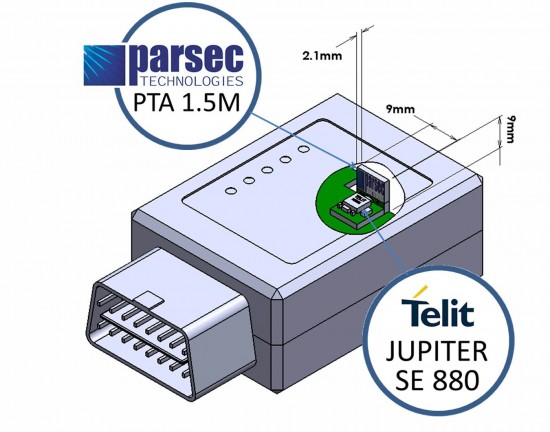
Telit Wireless Solutions and Parsec Technologies today announced that a combination of the companies’ technologies results in a low profile companion solution for GPS receiver and antenna. For host devices able to accommodate higher volumetric symmetry, assembly of the components can be made to fit a 6 x 16 x 8 millimeter volume. A flat component arrangement can yield an ultra-low-profile volume of 6 x 16 x 2.4 millimeters.
“Receivers combining the Parsec PTA/PT Family and Telit’s Jupiter SE880 modules deliver good user experience in finished LBS (location-based services) critical products without sacrificing design flexibility, ease of implementation or cost,” said Michael A. Neenan, CEO and founder of Parsec Technologies, Inc. “The combination is ‘bullet-proof’ in providing a rewarding design experience making RF work reliably, passing end-product regulatory compliance testing without re-test.”
“Miniaturization is a major enabler of new application areas for positioning and M2M,” said Taneli Tuurnala, Vice President and Head of GNSS Division of Telit Wireless Solutions. “With the Parsec antennas, the complete receiver features the industry’s ‘smallest landed footprint,’ making it suitable for use in wearable electronics, UBI devices or adapters for the mobile computing industry.”
Along with miniaturization, the receiver outperforms top traditional designs, handling a loss of 10 dB or greater in GPS signal reaching, for example, the typical OBD port under a vehicle’s dashboard where many usage-based insurance (UBI) dataloggers are installed. The PTA1.5M active antenna delivers the ultra-sensitive Jupiter SE880 micro receiver over 15 dB of additional gain in the operating frequency range. Both companies are making available complete application notes to simplify the engineering effort for system integrators.
The miniature 4.7 x 4.7 millimeter LGA (Land Grid Array), SiRFstarIV-based Jupiter SE880 receiver module employs heterogeneous 3D integrated technology to achieve best-in-class performance in all dimensions critical for regular or size-constrained GPS applications. Its RF front-end employs spatially calibrated waveguide-quality radio paths inside the three-dimensional space of its architecture, reducing parasitic impedances characteristic of traditional 2-D RF designs. Inside, a multi-filter system includes not only the traditional SAW filters typical in GPS receiver designs but also a 2.4-GHz notch-filter capable of nullifying the jamming effects of high-energy radio devices such as Wi-Fi hot-spots, Bluetooth systems, cordless phones, and others, which greatly affect a GPS receiver’s ability to resolve timid satellite signals in the hostile radio environment where they need to operate.
The PTA1.5M, with a gain of 15dB, and PTA1.5x2M, with a gain of 30dB, are tiny GNSS active antenna modules capable of receiving signals down to -192 dBm with frequency centered at 1575.42 (±1.023) MHz. Either model delivers a radiated efficiency greater than 60% when mated to the Jupiter SE880 receiver. Parsec’s PT1233D LNA also has the highest available IP3 at low voltage, helping eliminate interference. Both PTA1.5M and PTA1.5x2M can incorporate the antenna element, an optional SAW filter, the cascadable PT1233D LNA, matching and passives components, on a low cost, easy to integrate 10×16 mm single sided PCBA with “back side” copper clad ground plane. The height of the PTA1.5M and PTA1.5x2M modules vary according to application, allowing their use in even the smallest form factors including Intel’s M.2 Next Generation Form Factor (NGFF) module (23x30x2.4 mm, LxWxH).
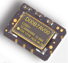
COSPAS-SARSAT beacons are battery operated emergency distress transmitters for locating ships or persons when time is critical for survival. The new Connor-Winfield series CSBxx Series are Surface Mount, 5x7mm, 3.3V, LVCMOS or Clipped Sinewave Temperature Compensated Crystal Oscillators (TCXO) designed to be emergency beacon frequency references requiring tight ± 0.2 ppm frequency stability and frequency slope control of only ±0.7 ppb/min.
The low power dissipation of 6mW allows it to power-up immediately with an accurate frequency. Class 1 devices operate over –40°C to 55°C and Class 2 devices operate–20°C to 55°C. Standard frequencies are 10.0, 12.688375, 12.688575, 12.688656, 12.68875, 16.367, and 20.0 MHz. To save time during the beacon certification process, temperature test data is available from a special on-line URL for each serialized TCXO.
Features:
3.3 Vdc Operation
Frequency Stability: ± 0.20 ppm
Mean Slope = ±0.7 ppb/min
Temperature Ranges Available:
Class I -40 to 55°C , Class II -20 to 55°C
LVCMOS or Clipped Sinewave Output
Ceramic Surface Mount Package
Tape and Reel Packaging
RoHS Compliant / Pb Free
Each unit is serialized and data is available on-line
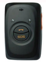
GPS tracking company Meitrack is offering the MT90, a GPS personal tracker for elderly, children, patients and lone workers. It can be hung around the neck or carried in a pocket or bag. The MT90 weights 65 grams and is 77 x 47 x 20 millimeters in size.
The MT90 can last 16 hours in normal mode and up to 60 hours in power-saving mode. It is waterproof to IP66 standards, and can handle 5% to 95% air humidity, which ensures it is reliable in the case of unexpected rain or accidents with small children.
MT90 is Meitrack’s first GPS tracker that works with SiRFStar IV GPS and quad band GSM 850/900/1800/1900 Mhz base station, facilitating bi-module positioning technology. Using this advanced technology, the MT90 can more accurately and precisely track its location.
Equipped with an SOS button, people using the MT90 tracking device are only one click away from calling the Rescue Service Center for help. In addition, the SOS button can be programmed to call multiple emergency numbers until one picks up. This device can facilitate two-way communication along with the option to listen-in, which can be helpful when discretely trying to locate a missing person.
The MT90 GPS tracker uses Meitrack’s protocol to track by SMS and GPRS. The MT90 has an built-in motion sensor, built-in battery, GPS blind area alarm, low-battery alarm and speeding alarm.
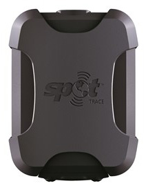
SPOT LLC, a wholly owned subsidiary of Globalstar, Inc., has launched its SPOT Trace anti-theft asset tracking device. SPOT Trace ensures cars, motorcycles, boats, ATVs, snowmobiles and other valuable assets are where they need to be, notifying owners via email or text when movement is detected anytime, anywhere. SPOT’s growing family of products uses 100% satellite technology to provide location-based messaging and emergency notification for on or off the grid communications.
SPOT Trace users can view their boat, ATV, motorcycle or other asset’s GPS coordinates online 24 hours a day in near real-time through Google Maps. With multiple mounting options, SPOT Trace is small and durable enough to be placed practically anywhere. With up to 18 months of battery life, affordable rate plans and satellite coverage that goes beyond the reach of cellular coverage, there is no comparable product on the market to track anything, anytime, anywhere. Other SPOT Trace features include:
Tracking. View your asset’s GPS coordinates from your smartphone or online
Movement Alerts. Receive texts/emails when SPOT’s vibration sensor detects your asset has new movement
Dock Mode. Configure your device to track an asset that is primarily stored on the water
Power Off Message. Receive a notification if your device is powered off
Low Battery Message. Receive a notification when the device’s batteries are low
Status Message. Receive a once per day alert to let you know your asset is secure
SPOT Trace also features customizable tracking, which allows users to track an asset’s GPS coordinates at 2 1/2, 5, 10, 30 or 60 minute
intervals. The units will sell starting at $99.95, with service plans from $99.99/year.